
NPS photo/Neal Herbert
This region is one of the world's premier natural showcases for Earth history. Encompassing 130,000 square miles, the Colorado Plateau straddles the region known as The Four Corners, where the states of Arizona, Utah, Colorado, and New Mexico meet. Ancient volcanic mountains, plateaus and buttes, deeply carved canyons, and amazing ranges in color are the region's defining characteristics. Elevation for the Colorado Plateaus starts at about 610 m (2,000 ft) above sea level, with plateau tops ranging from 1,534 to 2,134 m (5,000 to 7,000 ft) and mountaintops reaching nearly 3,960 m (13,000 ft).
Ancient Precambrian rocks, exposed only in the deepest canyons, make up the basement of the Colorado Plateau. Igneous rocks injected millions of years later form a marbled network through parts of the Colorado Plateaus' darker metamorphic basement. These rocks formed deep beneath the surface of the earth and were uplifted, eroded, and exposed for eons. By 600 million years ago North America had been eroded to a remarkably smooth surface. It is on this crystalline rock surface that the younger, more familiar layered rocks of the Colorado Plateaus were deposited.
Educational Resources
Interpretive Training Manual: Grand Canyon National Park
- The Grand Canyon Geology Training Manual overviews the park's geology, including information that ranges from the introductory level to more advanced concepts. It was written to help interpreters, tour guides, and teachers learn more about the canyon's geology & physiographic provinces, and to help them share the park's geology with others.
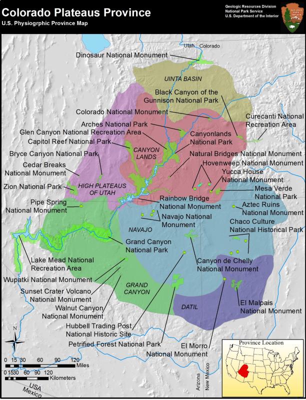
Colorado Plateaus Parks
")
NPS photo/Debra Miller
- Arches National Park, Utah—[Geodiversity Atlas] [Park Home]
- Aztec Ruins National Monument, New Mexico—[Geodiversity Atlas] [Park Home]
- Black Canyon of the Gunnison National Park, Colorado—[Geodiversity Atlas] [Park Home]
- Bryce Canyon National Park, Utah—[Geodiversity Atlas] [Park Home]
- Canyon de Chelly National Monument, Arizona—[Geodiversity Atlas] [Park Home]
- Canyonlands National Park, Utah—[Geodiversity Atlas] [Park Home]
- Capitol Reef National Park, Utah—[Geodiversity Atlas] [Park Home]
- Cedar Breaks National Monument, Utah—[Geodiversity Atlas] [Park Home]
- Chaco Culture National Historical Park, New Mexico—[Geodiversity Atlas] [Park Home]
- Colorado National Monument, Colorado—[Geodiversity Atlas] [Park Home]
- Curecanti National Recreation Area, Colorado—[Geodiversity Atlas] [Park Home]
- Dinosaur National Monument, Colorado & Utah—[Geodiversity Atlas] [Park Home]
- El Malpais National Monument, New Mexico—[Geodiversity Atlas] [Park Home]
- El Morro National Monument, New Mexico—[Geodiversity Atlas] [Park Home]
- Glen Canyon National Recreation Area, Arizona & Utah—[Geodiversity Atlas] [Park Home]
- Grand Canyon National Park, Arizona—[Geodiversity Atlas] [Park Home]
- Hovenweep National Monument, Colorado & Utah—[Geodiversity Atlas] [Park Home]
- Hubbell Trading Post National Historic Site, Arizona—[Geodiversity Atlas] [Park Home]
- Lake Mead National Recreation Area, Arizona & Neveda—[Geodiversity Atlas] [Park Home]
- Mesa Verde National Park, Colorado—[Geodiversity Atlas] [Park Home]
- Natural Bridges National Monument, Utah—[Geodiversity Atlas] [Park Home]
- Navajo National Monument, Arizona—[Geodiversity Atlas] [Park Home]
- Petrified Forest National Park, Arizona—[Geodiversity Atlas] [Park Home]
- Pipe Springs National Monument, Arizona—[Geodiversity Atlas] [Park Home]
- Rainbow Bridge National Monument, Utah—[Geodiversity Atlas] [Park Home]
- Sunset Crater National Monument, Arizona—[Geodiversity Atlas] [Park Home]
- Walnut Canyon National Monument, Arizona—[Geodiversity Atlas] [Park Home]
- Wupatki National Monument, Arizona—[Geodiversity Atlas] [Park Home]
- Yucca House National Monument, Colorado—[Geodiversity Atlas] [Park Home]
- Zion National Park, Utah—[Geodiversity Atlas] [Park Home]
Related Links
Moab Happenings
- Geology Happenings—The Geologist’s Life List, Moab Edition
- Geology Happenings—Standing Tall: Mesas, Buttes and Spires
- Geology Happenings—The Geology of the Uranium Capital of the World
- Geology Happenings—The Geology of Hanging Gardens
- Geology Happenings—Moab and the Colorado Plateau
Part of a series of articles titled Physiographic Provinces.
Previous: Coastal Plain Province
Last updated: January 20, 2026