Last updated: December 13, 2024
Article
NPS Geodiversity Atlas—Canyonlands National Park, Utah
Geodiversity refers to the full variety of natural geologic (rocks, minerals, sediments, fossils, landforms, and physical processes) and soil resources and processes that occur in the park. A product of the Geologic Resources Inventory, the NPS Geodiversity Atlas delivers information in support of education, Geoconservation, and integrated management of living (biotic) and non-living (abiotic) components of the ecosystem.
Introduction
Canyonlands National Park was established to preserve the striking geologic landscapes and associated ecosystems and the magnificent scenic, scientific, and cultural features of the area around the confluence of the Green and Colorado Rivers in southeastern Utah.
The rivers divide the park into three districts. The Needles District is located east of the Colorado River, the Maze District is west of the rivers, and the Island in the Sky District is between the two rivers, with its mesa top standing high above the canyons below it.
Canyonlands National Park’s superlative geologic resources include its well-exposed section of late Paleozoic and Mesozoic sedimentary rocks and its classic landforms formed by arid-land erosion.
Geologic Significance & Geodiversity Highlights
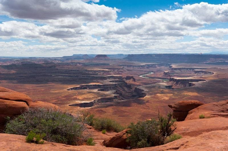
NPS photo.
Canyonlands National Park’s 527 square miles (1,365 km2) contain some of the most scenic lands in the American southwest and encompass a wide array of erosional landforms including canyons, natural arches, rock alcoves, mesas, buttes, and spires. The park is known for its miles of red rock cliffs, soaring rock alcoves and domes, rounded rock spires in the Needles District and the Maze District’s Doll House, and enigmatic features such as Upheaval Dome. It is not nearly as deep as Grand Canyon, but its quintessential canyon landscapes rival those of the better-known park.
Canyonlands National Park offers scenic vistas, hiking, backpacking, mountain biking, and rough four-wheel drive roads as well as outstanding opportunities for solitude, natural quiet, and contemplation of the geologic events that have shaped the planet.
Sandstonelands
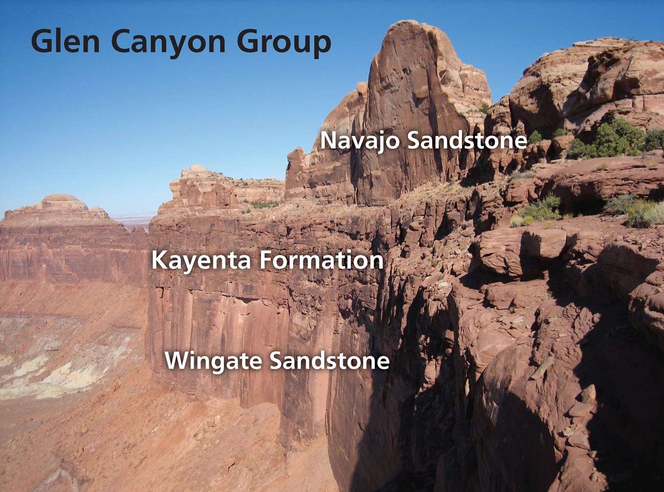
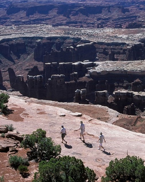
Photo by Allyson Mathis. Originally published in Moab Happenings.
Canyonlands National Park contains a wide variety of sedimentary rock types including sandstone, siltstone, mudstone, limestone, and bedded gypsum. But sandstone is the most prevalent rock type in the park. Most of the park’s prominent landscape features are made of sandstone. Specifically, eolian sandstones (e.g., those made of grains transported and deposited by the wind) dominate the park. Important eolian units exposed in Canyonlands include Cedar Mesa, White Rim, Wingate, and Navajo sandstones.
Young Erosional Landscape
The cliffs, canyons, natural arches, alcoves, mesas, buttes, and rock spires that make up the landscape of Canyonlands National Park are all extremely young erosional features.
The park is located within the part of the Colorado Plateau that is undergoing very rapid erosion, with the current landscape most likely being carved during the last few million years.
Paleontological Resources
With its rock record spanning from the late Paleozoic to the Mesozoic and with diverse depositional environments, Canyonlands National Park has a rich fossil record.
Most of the rock units exposed in the park contain fossils. Marine invertebrate fossils including brachiopods, crinoids, bryozoans, corals, and rare vertebrate fossils have been found in the Paleozoic units, especially the Honaker Trail Formation and lower Cutler beds, as well as some Mesozoic rocks.
The Chinle Formation is the most fossiliferous of Canyonlands’ Mesozoic units. Petrified wood is common in the Chinle, and the unit also contains other plant fossils, as well as invertebrate and vertebrate fossils.
Pleistocene packrat middens in alcoves and overhangs are present in the park and may contain pollen, invertebrate, and other fossils.
Other fossils found in Canyonlands National Park include:
-
Cedar Mesa Sandstone: Root traces and burrows
-
Moenkopi Formation: Marine invertebrate fossils and swimming trackways
-
Kayenta Formation: Dinosaur tracks
All NPS fossil resources are protected under the Paleontological Resources Preservation Act of 2009 (Public Law 111-11, Title VI, Subtitle D; 16 U.S.C. §§ 470aaa - 470aaa-11).
Related Links
Geologic Setting
Canyonlands National Park is located in the heart of the Colorado Plateau, one of 25 physiographic provinces in the contiguous United States. The Colorado Plateau has an overall high elevation, thick continental crust, and has experienced relatively little structural deformation. The arid to semiarid environment as well as the immense erosional power of the Colorado and Green rivers and their tributaries has led to excellent exposures of sedimentary rock units in the park.
Colorado Plateau
The Colorado Plateau covers approximately 130,000 square miles (337,000 km2) across the Four Corner states of Utah, Colorado, New Mexico, and Arizona. The greatest concentration of national park sites in the country, including 30 units of the National Park System, is found on the Colorado Plateau.
The Colorado Plateau is divided into six sections, each with a distinctive character. Canyonlands is within the Canyon Lands section of the Colorado Plateau, which is dominated by gently tilted sedimentary rock layers that have been intricately carved into canyons.
The Colorado Plateau has a complex geologic history and experienced multiple periods of uplift. Much of the uplift of the Canyonlands region occurred during the Laramide orogeny, a mountain-building event that impacted most of the interior west, between 70 and 40 million years ago. Unlike the neighboring Rocky Mountains, the Colorado Plateau was relatively undeformed, experiencing general uplift and the formation of broad upwarps throughout the region. One of these folds, the Monument uplift, extends into the park from the south and tapers out a bit north of the confluence of the Green and Colorado Rivers.
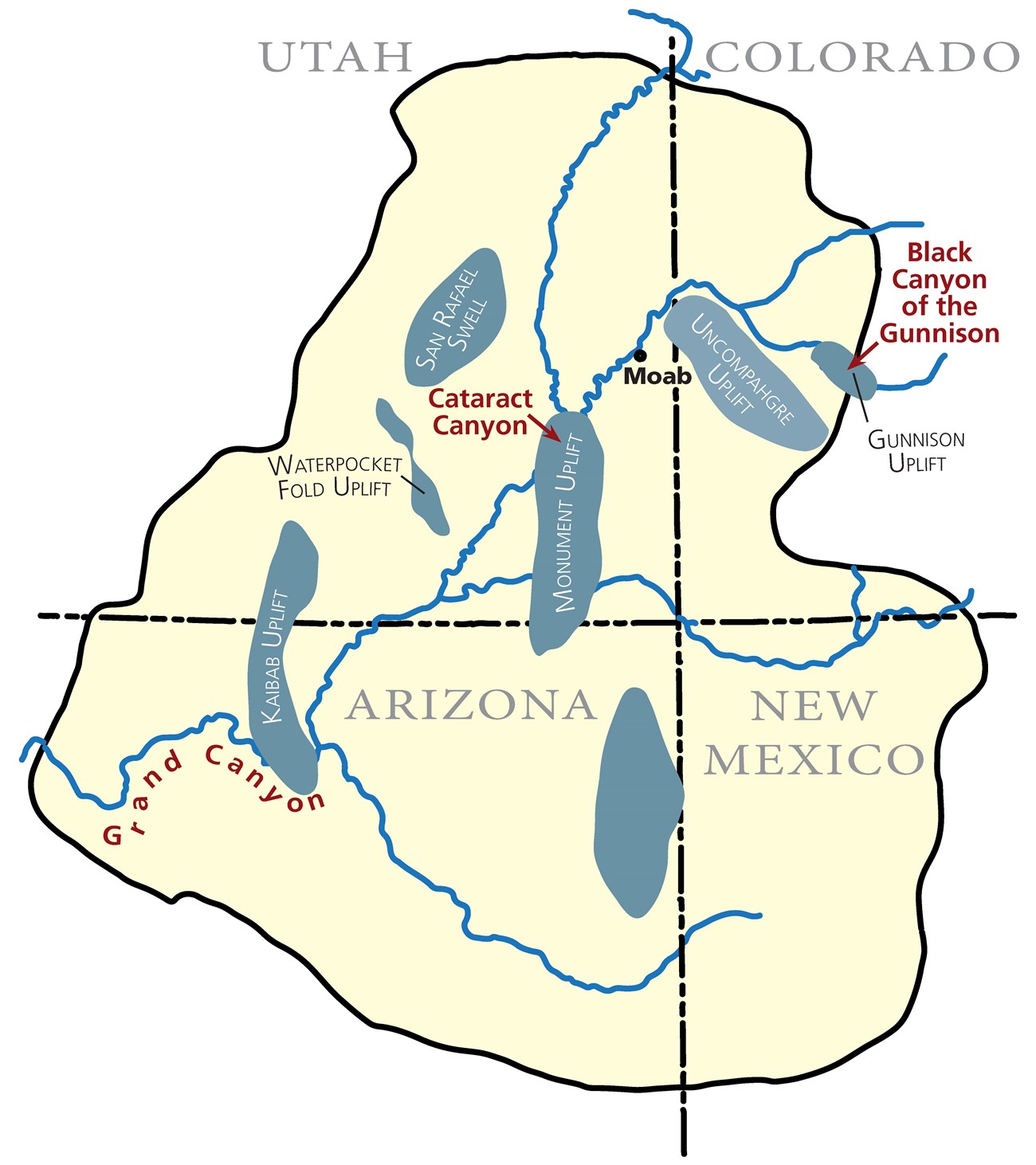
Diagram by Allyson Mathis. Originally published in Moab Happenings.
Related Links
Geologic History and Stratigraphy
Rocks exposed in Canyonlands National Park were deposited between about 310 and 160 million years ago (late Paleozoic through the Mesozoic eras) in both marine and continental environments spanning the time period when the Ancestral Rocky Mountains (to the northeast of the park) that were formed during the Pennsylvanian and Permian were eroding away during subsequent time periods.
The geologic history of the greater Canyonlands region changed dramatically with the onset of the Laramide Orogeny, the mountain building event that formed the Rocky Mountains and uplifted the Colorado Plateau. The erosional events that formed the park’s landforms are very recent, occurring within the last few million years. Incision by the Green and Colorado rivers and evolution of the Canyonlands landscape occurred after the river system established its course to the Gulf of California.
Paleozoic Era
Paleozoic rock units exposed in Canyonlands National Park include (from oldest to youngest):
The Pennsylvanian Paradox Formation is the oldest rock exposed in Canyonlands National Park, and was deposited approximately 310 million years ago. Although surface exposures are limited to a few small areas in Cataract Canyon, the Paradox Formation is important to the overall geology of the park.
The Paradox Formation contains thick sequences of salt and other evaporite minerals. It was deposited in a restricted basin that was periodically cut off from normal marine conditions so evaporation caused gypsum, halite, and potash to precipitate.
Salt has two unique properties as a rock type. It can flow plastically when under the pressure caused by burial by overlying sediments. It is also less dense than other types of rock so it flows upwardly, doming the layers above it.
Several salt anticlines, where upwardly flowing salt domed the rocks above it, are present in the park along the Colorado River. The Grabens in the Needles District also formed as a result of salt movement.
The total thickness of the Paradox Formation in the subsurface of Canyonlands is up to approximately 6,000 feet (1,800 m) thick, but may be locally thicker due to salt flowage.
The Pennsylvanian Honaker Trail Formation in Canyonlands National Park consists mostly of sandstone, fossiliferous limestone, and shale, with some evaporite deposits and is exposed in the walls of Cataract Canyon. It was deposited about 305 million years ago and is approximately 3,000 feet (900 m) thick in the park. The Honaker Trail was deposited mostly under normal marine conditions.
The stratigraphy of the Cutler Group in Canyonlands National Park is complex. Regionally, the Cutler Group is the package of Permian sediments that were eroded off the Uncompahgre highlights of the Ancestral Rockies Mountains in western Colorado (northeast of Canyonlands). The Cutler consists of thick sequences of arkosic sandstone conglomerate closer to the source, but in the Canyonlands region, geographic variations in depositional environments allow differentiation of different formations within the Cutler Group.
In Canyonlands National Park, the Cutler Group is divided (from oldest to youngest) into the lower Cutler beds (Halgaito and Elephant Canyon formations), Cedar Mesa Sandstone, Organ Rock Formation, and White Rim Sandstone. These units were deposited between 290 and 275 million years ago and have a total thickness of up to 2,500 feet (760 m) in the park.
Lower Cutler Beds/Elephant Canyon Formation/Halgaito Formation
The lowest Cutler beds have also been mapped as the Halgaito and Elephant Canyon formations, but these stratigraphic designations have not been universally accepted by geologists. Some find that the contact between the Elephant Canyon Formation and overlying Cedar Mesa Sandstone is hard to identify, and therefore, think that this unit does not strictly adhere to stratigraphic codes. The informal term lower Cutler beds is sometimes used for these rocks. Some geologic maps of the park also show the Halgaito Shale.
Variations in paleogeography and depositional environments led to the deposition of two distinct eolian units, the Cedar Mesa and White Rim sandstones. The Cedar Mesa Sandstone is slightly older than the White Rim Sandstone and was formed in a large sand dune field where the northeastern boundary was near the boundary of the Needles District of Canyonlands. The White Rim erg was located slightly to the north of the Cedar Mesa erg with its eastern boundary being close to the current location of the Colorado River.
Cedar Mesa Sandstone
The eolian Cedar Mesa Sandstone was deposited in a large erg with its northeastern boundary near the Needles District of Canyonlands. It thickens to the west in the Maze District as well as to the south where it is also exposed in Navajo Bridges National Monument, but pinches out to the east and north of the confluence of the Green and Colorado Rivers. The Cedar Mesa’s cross stratification indicates that the wind direction was from the northwest.
In the Needles District, the Cedar Mesa sandstone includes evidence of different dune types (sand sheets, and barchan and tranverse dunes), as well as interdunal ponds and root casts.
In addition to angled crossbedding, the Cedar Mesa contains distinct horizontal layers. These flood surfaces formed during fluvial flooding of the erg, leaving thin dark red layers that are softer and less resistant to erosion that the eolian strata. The alternative red-orange to tan banding of the eolian strata results from differential bleaching by fluids by diagenesis.
Organ Rock Formation
The Organ Rock Formation is found in the Island in the Sky and Maze Districts. It consists mostly of thinly bedded sandstone, siltstone, and pebbly conglomerate that are dark-red in color. It was deposited in braided river channels, floodplains, and localized ergs. The Organ Rock Formation can form vertical cliffs especially where protected by the overlying White Rim Sandstone.
White Rim Sandstone
The eolian White Rim Sandstone was deposited in an erg whose eastern margin was close to the current location of the Colorado River. As a result, it pinches out to the east and is not present in the Needles District. It thickens to the west and is much thicker on the Green River side of the White Rim bench and in the Maze District relative to eastern exposures. The White Rim Sandstone’s white color is a result of bleaching by hydrocarbon-rich fluids during diagenesis between about 35 and 40 million years ago. The White Rim Sandstone is much more resistant to erosion than the units above and below it (Moenkopi and Organ Rock formations respectively).
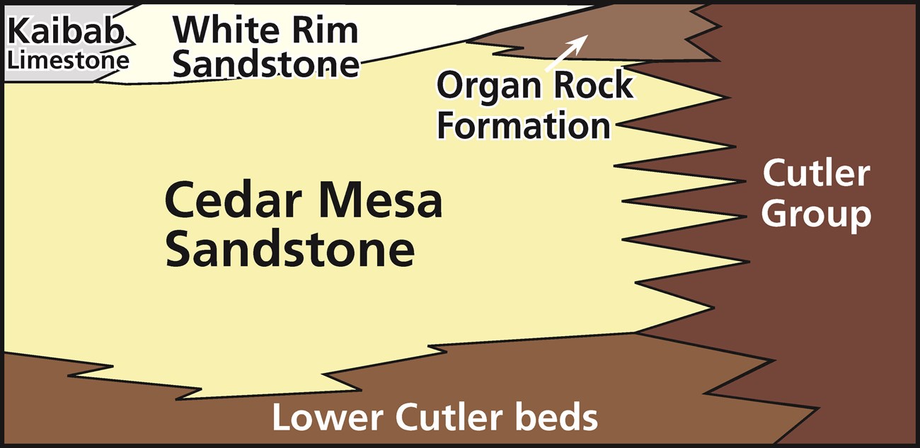
The intertonguing relationships and stratigraphy of the Cutler Group in Canyonlands National Park.
Diagram by Allyson Mathis After Chan, M.E. (1989). Erg margin of the Permian White Rim Sandstone, SE Utah. Sedimentology.
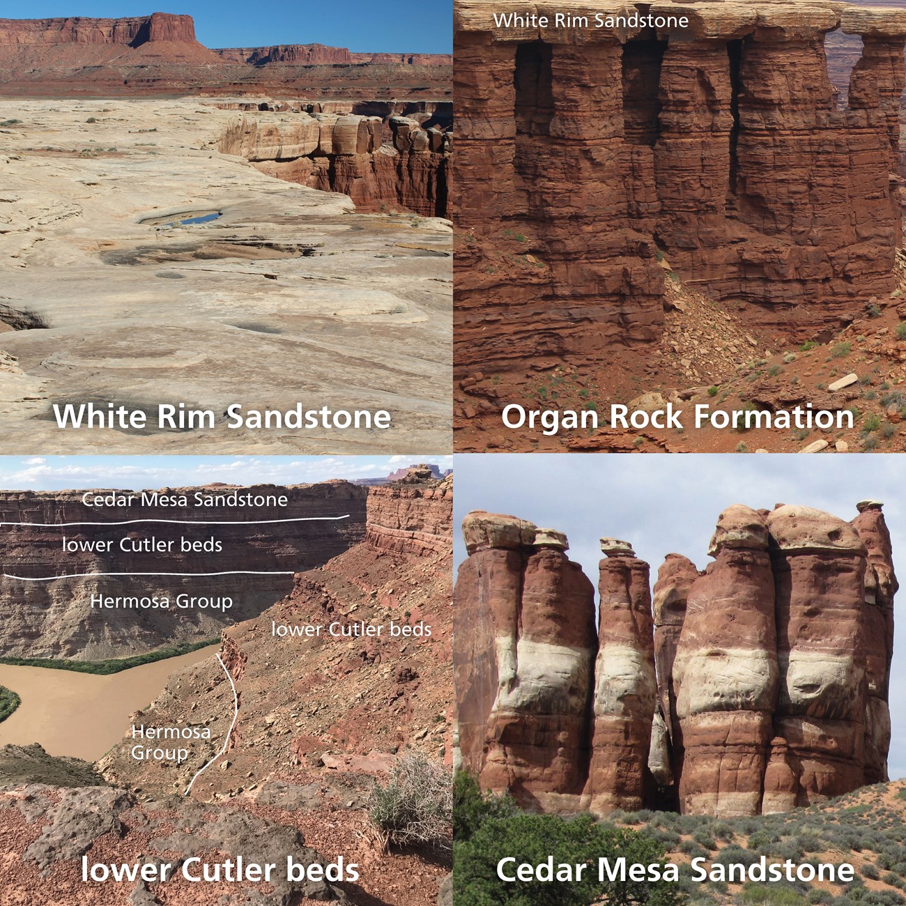
The units of the Cutler Group in Canyonlands National Park.
Photos by Allyson Mathis. Originally published in Moab Happenings.
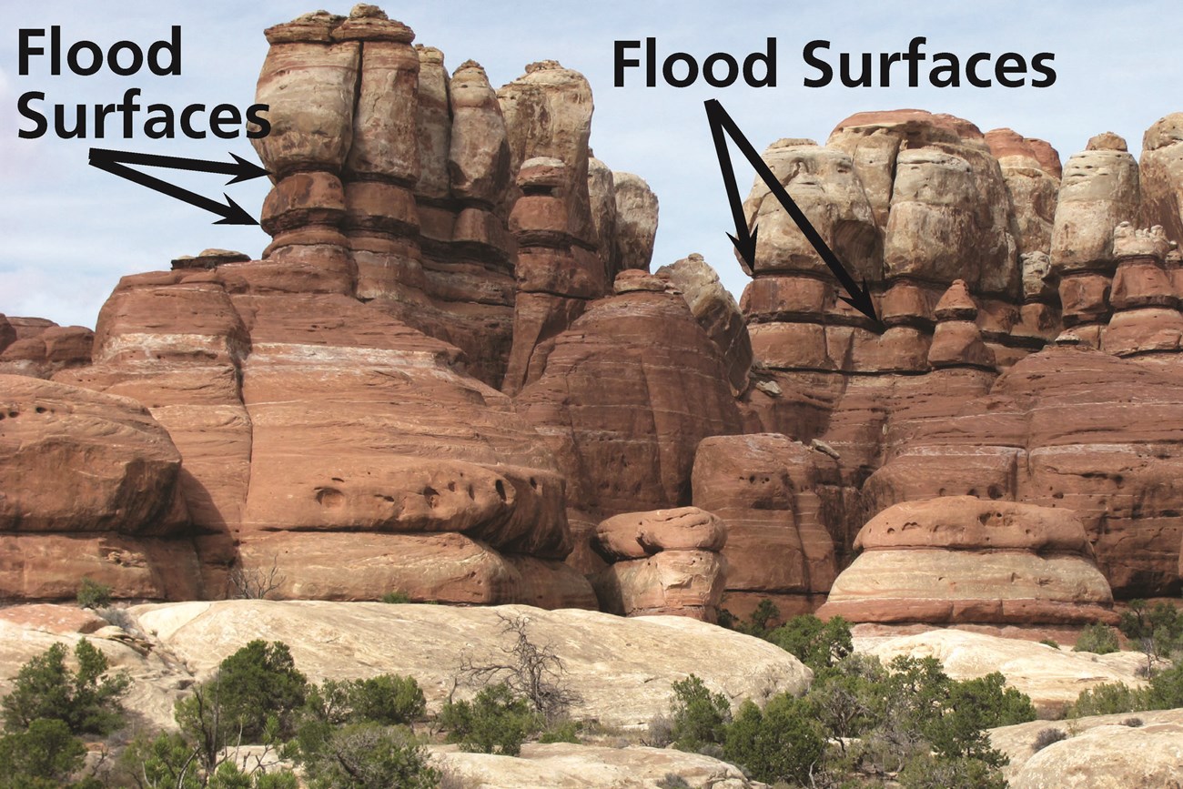
Eolian Cedar Mesa Sandstone with thin flood surfaces in the Needles District.
Photo by Allyson Mathis. Originally published in Moab Happenings.
Mesozoic Era
Mesozoic rock units exposed in Canyonlands National Park include (from oldest to youngest):
The Triassic Moenkopi Formation consists of a series of mostly brick red thinly bedded sandstones and siltstones with abundant ripple marks that were deposited in shallow marine, tidal flat, and river floodplain environments about 240 million years ago. The climate was hot and arid at the time. The Moenkopi is between 400 and 700 feet (120 to 210 m) thick in the park and is exposed in the Island in the Sky District as well as the Orange Cliffs unit of Glen Canyon National Recreation Area with some exposures in the Maze District.
The Chinle Formation was deposited in the Late Triassic, between about 230 and 205 million years ago. The unit consists of colorful mudstones and ledgey sandstones that were deposited in a monsoonal climate in the channels and floodplains of river systems. Fossils in the Chinle Formation include vertebrates and abundant petrified wood. Uranium ore bodies in the Chinle Formation were mined for uranium prior to park establishment.
The Chinle Formation is between 350 and 650 feet (100 to 200 m) thick in the park, and like the underlying Moenkopi Formation, it is exposed in the Island in the Sky District as well as in the Maze and Orange Cliffs.
The Glen Canyon Group consists of three sandstone units in Canyonlands National Park. The Wingate Sandstone and Kayenta Formation together form the vertical cliffs of the Island in the Sky as well as the Orange Cliffs west of the Maze District in Glen Canyon National Recreation Area.
Wingate Sandstone
The Triassic-Jurassic Wingate Sandstone was deposited between 202 and 195 million years ago in an eolian environment. The Wingate erg (sand sea) covered much of southeastern Utah and extends to the southeast past the Four Corners. The Wingate Sandstone is about 350 feet (100 m) thick in the park.
Kayenta Formation
The Kayenta Formation was deposited in a fluvial environment where large sandy braided river systems flowed to the west out of the Ancestral Rocky Mountains in western Colorado. The Kayenta has low-angle cross-bedding typical of fluvial deposition. The unit is very resistant to erosion and it caps the Island in the Sky mesa. The Kayenta Formation is about 350 feet (100 m) thick in Canyonlands National Park.
Navajo Sandstone
With the exception of a few occurrences of the Carmel Formation in the Horseshoe Canyon Unit, the Navajo Sandstone is the youngest rock in Canyonlands. It was deposited during the Jurassic at about 185 million years ago. The Navajo is less than 500 feet (150 m) thick in Canyonlands, which is only a fraction of the 2,000 feet (600 m) thickness in Zion National Park. The Navajo Sandstone was deposited in the largest sand dune system in North America’s geology history, covering approximately 230,000 square miles (600,00 km2).
The walls of Horseshoe Canyon are mostly of the Navajo Sandstone and it is exposed on the Island in the Sky mesa top where it forms white sandstone domes. Mesa Arch and Aztec Butte are both in the Navajo Sandstone.
The Jurassic Carmel Formation is only exposed within Canyonlands National Park in the Horseshoe Canyon Unit where it is exposed on benches above the canyon. It consists of sediments deposited in tidal flat and mud flat (sabkha) environments in the Jurassic Period about 170 million years ago.
Cenozoic Era
The Cenozoic geologic history of the Canyonlands region is strikingly different than its previous geologic history. Instead of being part of depositional basins, as it was throughout much of the Late Paleozoic and Mesozoic, southeastern Utah was impacted by the tectonic and erosional events that have shaped the entire Intermountain West, and ultimately led to the formation of the dramatic canyon scenery that the park was established to protect.
Rocks exposed in Canyonlands National Park were deposited at or near sea level, but now stand as high as 7,000 feet (2,100 m) in elevation. Further, it is estimated that the park’s youngest rock layers were once buried by an additional 4,000 to 6,000 feet (1,200 to 1,800 m) of sedimentary rocks above them and that have been removed by erosion.
The Colorado Plateau has a complex geologic history and experienced multiple periods of uplift.
Laramide Orogeny
Most of the uplift of the Canyonlands region and the surrounding Colorado Plateau occurred during the Laramide Orogeny between 70 and 40 million years ago.
The Laramide Orogeny impacted a wide area much broader than what occurs above a typical subduction zone. The unusual tectonics of the Laramide Orogeny was caused by the subduction of a large oceanic plateau within the Farallon plate, where unusually thick oceanic crust caused the subduction angle to shallow so that orogenic forces extended far from the tectonic boundary.
In addition to regional uplift, the Laramide Orogeny formed several major uplifts including the Monument Uplift and other major monoclines including the Waterpocket Fold in Capitol Reef National Park.
Mid-Cenozoic Uplift
The Mid-Cenozoic Uplift was the first of two additional periods of uplift consequent to the tectonics of the Laramide Orogeny. It occurred between 35 and 25 million years ago, an interval during which shallow igneous intrusions formed the three laccolithic mountain ranges (La Sal, Abajo, and Henry) that surround the park.
Hot asthenosphere inflowing above the sinking Farallon slab underneath the Colorado Plateau caused the surface uplift.
Post-10-Million-Year Uplift
The most recent period of tectonic uplift took place within the last 10 million years due to complex mantle processes following the subduction of the Farallon plate.
Isostatic Rebound
Some of the uplift of the Canyonlands region is the result of isostatic response following erosion of thousands of feet of overlying sedimentary rocks and the incision by the Colorado and Green rivers. Erosional isostatic rebound occurs when Earth’s crust deforms and uplifts after removal of great thicknesses of surficial rock or sediments decreases the pressure on the asthenosphere allowing it to rise.
The landscape of Canyonlands National Park is geologically very young and has undergone very rapid erosion.
In the big picture, canyon incision on the Colorado Plateau was initiated after the integration of the upper Colorado River to the Gulf of California which occurred within the last 5 to 6 million years. Important evidence that constrains the age of the modern Colorado River is present near Grand Junction, Colorado and below Grand Canyon National Park in Arizona.
Landscape evolution in the central Colorado Plateau where Canyonlands is located appears to have occurred even more recently, with much of the erosion most likely occurring during rapid exhumation during the last two to three million years or so.
The entire Colorado Plateau has undergone extensive erosional stripping with up to 5,000 to 13,000 feet (1,500 to 4,000 m) of erosion centered over the central Canyonlands region, with lesser amounts of erosion progressively towards the edges of the plateau.
Incision by the Colorado River has initiated and driven erosion throughout Canyonlands. Erosion moves up tributaries and cliffs retreat through mass wasting, rock fall, and sapping processes.
Erosion rates have been unsteady through time, with pulses of especially rapid erosion and periods of relative stability. Erosion rates in the Canyonlands region over the last several hundred thousand years have averaged 1,300 feet (400 m) per million years or more, which is among the highest rates of erosion on the Colorado Plateau.
Differential Erosion
Differential erosional is an important component of landscape evolution in the Canyonlands region. Differential erosion is that which occurs at different rates in rocks of varying resistance to erosion. Harder rocks like the White Rim Sandstone and Kayenta Formation erode at slower rates relative to softer units like the Moenkopi and Chinle Formations. Resistant layers can form hard cap rocks that hold up mesas, buttes, and spires and protect softer units below them from erosion.
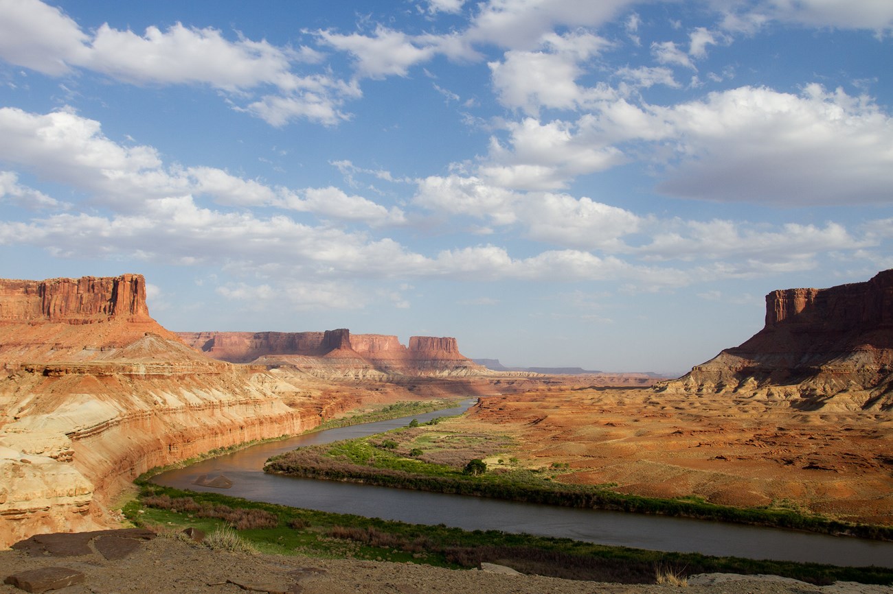
The Green River and the young Canyonlands landscape.
NPS photo by Andrew Kuhn.
Geologic Features and Processes
Needles District
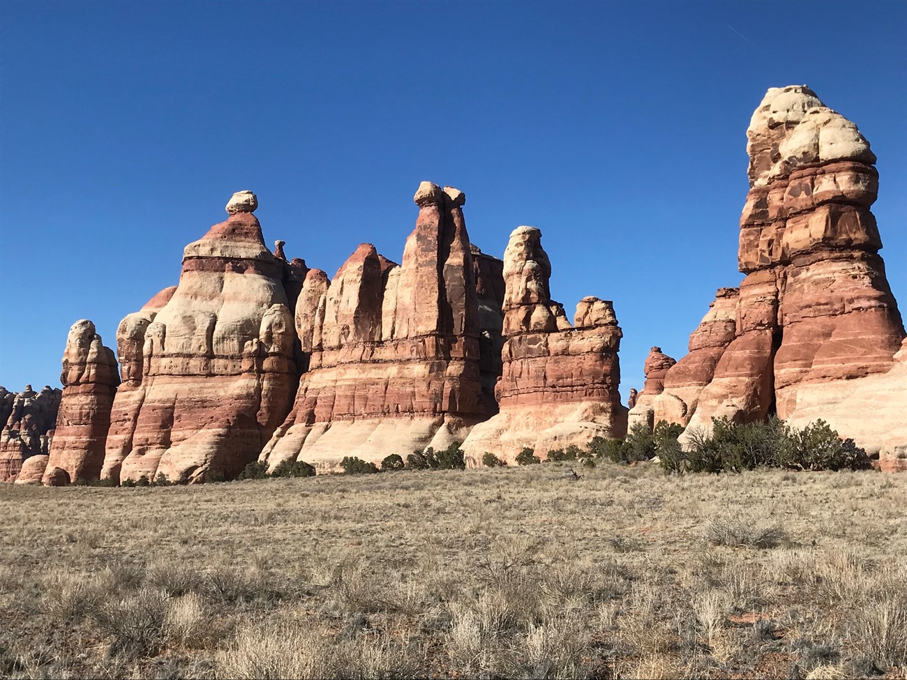
Photo by Allyson Mathis. Originally published in Moab Happenings.
The Needles District is named for the rock spires made of the Cedar Mesa Sandstone that are the dominant feature of the park east of the Colorado River. There, two sets of rock fractures (joints) intersect at roughly right angles. Erosion and widening of these joint sets have left free-standing rock spires and toadstool-shaped rocks. Rock spires form in areas where the Cedar Mesa Sandstone has a more uniform resistance to erosion, and toadstools form where a more resistant layer is undercut by more erosive strata underneath it.
Rock Layers/Stratigraphy
(Oldest to youngest)
-
Honaker Trail Formation: Limestone, sandstone, and shale beds exposed in Cataract Canyon.
-
Lower Cutler beds: Limestone and sandstone layers exposed in some of the district’s deeper canyons and in upper part of the walls of Cataract Canyon.
-
Cedar Mesa Sandstone: The predominant rock unit of the Needles District where it has been eroded into canyons with slickrock divides and the district’s eponymous rock spires.
Places and Geomorphology

The Grabens formed by salt flowage towards Cataract Canyon.
Diagram by Allyson Mathis. Originally published in Moab Happenings.
NPS photo by Neal Herbert.
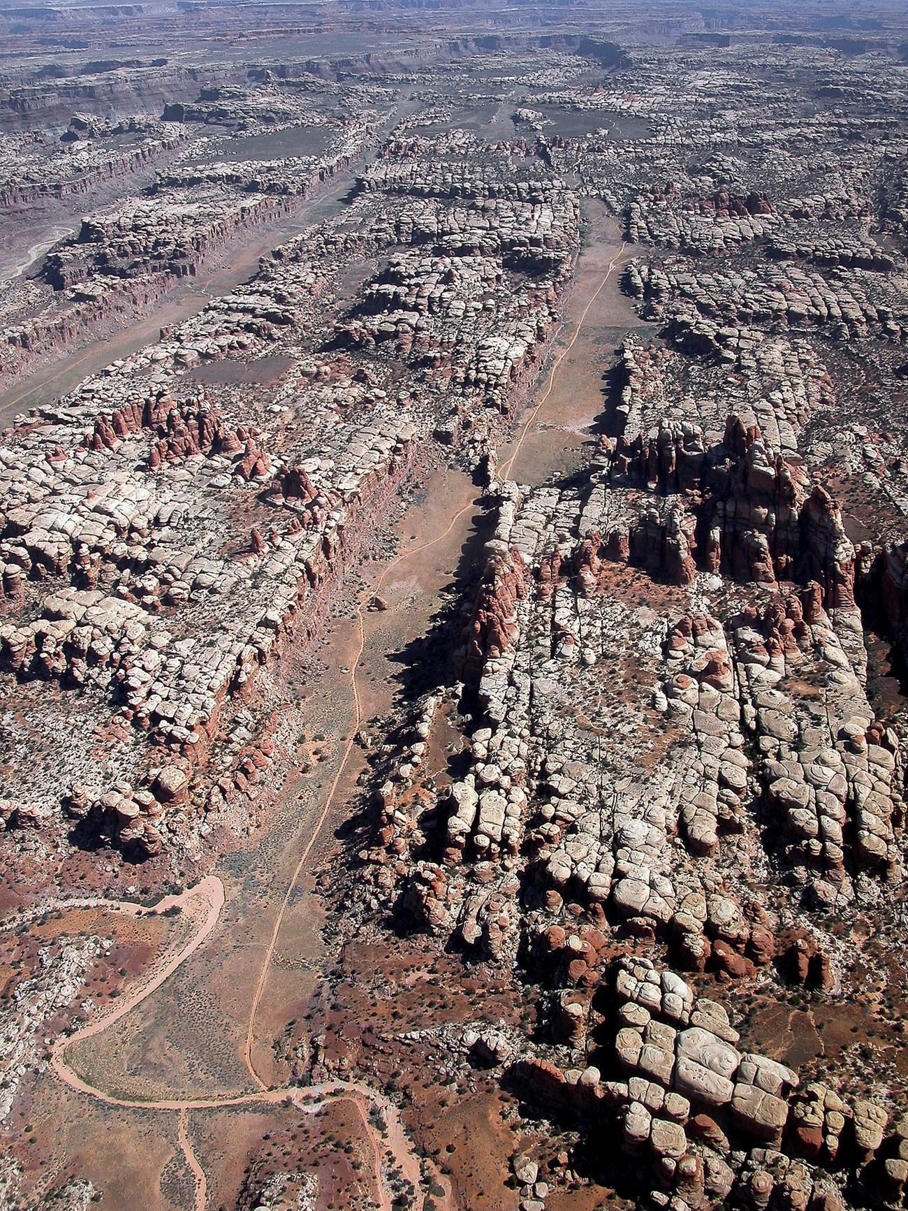
The Needles’ rock spires are best developed in and around Chesler Park, an area of open grassland on top of alluvium and colluvium surrounded by rock spires. The rock spires formed through erosion along two intersecting systems of vertical joints that intersect at nearly right angles.
The Joint Trail is a segment of the Chesler Park loop trail that travels through joints (rock fractures) that have been sufficiently widened through erosion and weathering to form a narrow path that people can travel. The joints are up to 40 to 50 feet (12 to 15 m) deep along the Joint Trail.
The Grabens are young topographical features caused by normal faulting related to salt tectonism. The incision of Cataract Canyon caused salt flowage to the west, causing extension in western part of the Needles District. The area accommodated this stretching by some blocks moving along parallel sets of faults downdropping relative to others to form grabens. Although they look like a series of parallel canyon with straight vertical walls, they were not formed by stream erosion.
Island in the Sky District
The Island in the Sky District contains nearly the complete stratigraphic section found in Canyonlands National Park. It has outcrops of the Honaker Trail Formation in the deepest parts of the canyons just above the rivers to the Navajo Sandstone on the mesa top. It has the most stereotypical canyon country landforms of cliffs and slopes leading from the canyon rim of the Island in Sky mesa top to the Colorado River below of any of the three Canyonlands districts.
Although it looks like a mesa when viewed from the Needles District, the Island in the Sky is not a true mesa as it is connected by a narrow spit of land (the Neck) to the rest of the high plateau to the north.
Rock Layers/Stratigraphy
-
Organ Rock Formation: Dark red thinly bedded sandstones and conglomerates exposed underneath the White Rim Sandstone.
-
White Rim Sandstone: Resistant white eolian sandstone that forms a broad bench approximately halfway between the Island in the Sky mesa and the rivers below.
-
Moenkopi Formation: The lower portion of the slopes above the White Rim leading up to the Island in the Sky mesa. Except where it has been bleached by hydrocarbons during diagenesis, the Moenkopi is deep red in color. Nearly ubiquitous ripple marks are the unit’s signature feature.
-
Chinle Formation: Colorful siltstones and ledgey sandstones make up the upper section of the slopes beneath the Island in the Sky cliffs.
-
Wingate Sandstone: Cliff-forming eolian sandstone usually cut by prominent vertical jointing that together with the Kayenta Formation form the Island in the Sky.
-
Kayenta Formation: Fluvial sandstones that make up the ledgey upper part of the Island in the Sky cliffs.
-
Navajo Sandstones: Forms white sandstone domes on the Island in the Sky mesa top.
Places and Geomorphology
Grand View Point is located at the southern terminus of the Island in the Sky where it provides panoramic views of the White Rim bench below and the Needles District in the distance to the southeast. Monument Basin below Grand View Point formed from tributaries incising through the White Rim Sandstone leaving spires of the Organ Rock Formation.
The White Rim is a broad topographic bench formed by the resistant White Rim Sandstone. A 99-mile (160-km) four-wheel drive road follows the edge of the White Rim providing a multiday adventure by jeep or mountain bike.
Mesa Arch is one of the best-known natural arches in Canyonlands National Park where it has formed in the Navajo Sandstone on the edge of the Island in the Sky.
Upheaval Dome is a unique feature in the Island in the Sky District that looks like a target when viewed from satellite imagery. The center of the feature is an erosional basin that looks like a crater. The origin of Upheaval Dome is unclear, and because of its deep erosion, may never be fully understood. Its rock layers have been upwarped into a dome (a circular anticline), but whether the structure is due solely due to salt flowage in the underlying Paradox Formation or if it formed consequent to a meteorite impact is inconclusive based on the available geologic evidence.
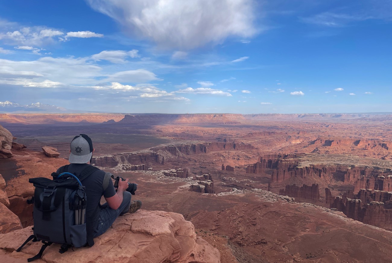
Grand View Point.
NPS photo by Nicole Segnini.
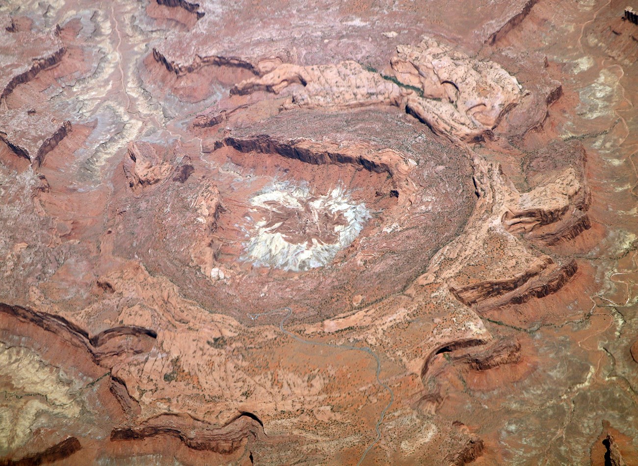
Upheaval Dome.
Doc Searls. Creative Commons Attribution 2.0 Generic.
Maze District
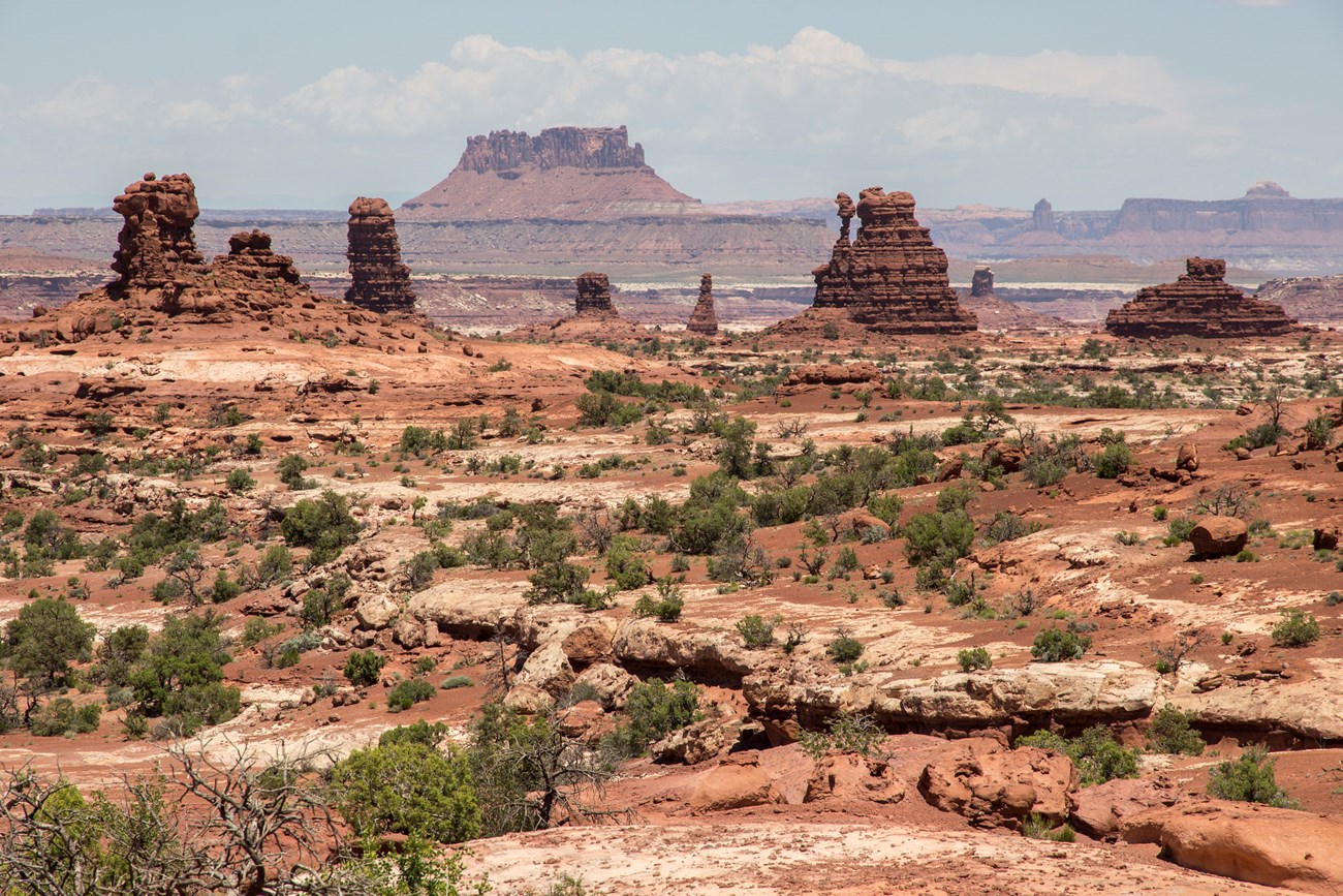
NPS photo by Kait Thomas.
The Maze District is the most rugged and remote section of Canyonlands National Park. Accessible only via difficult four-wheel drive roads or on foot, the Maze District is mostly made of a series of intricate side canyons with steep slickrock walls made of the Cedar Mesa Sandstone. Rock spires of the Organ Rock Formation sit below the Maze Overlook which is on a broad bench held up by the White Rim Sandstone.
Rock Layers/Stratigraphy
(Oldest to youngest)
-
Cedar Mesa Sandstone: Much of the Maze proper and the adjacent Doll House is made of the eolian Cedar Mesa Sandstone.
-
Organ Rock Formation: The Land of Standing Rocks, and the Chocolate Drops are characterized by vertical exposures of the Organ Rock Formation, sometimes with caps of the White Rim Sandstone.
-
White Rim Sandstone: Resistant eolian sandstone containing elaterite (tar) seeps.
-
Moenkopi Formation, Chinle Formation, Wingate Sandstone, and Kayenta Formation: Together these Mesozoic units form a set of slopes capped by vertical cliffs such as at Ekker and Elaterite Buttes and in the Orange Cliffs of Glen Canyon National Recreation Area.
Places and Geomorphology
The Maze gets its name from the labyrinth-like series of intricate canyons carved into the Cedar Mesa Sandstone. With slickrock canyon walls and vegetated canyon bottoms, the region truly looks like a maze when viewed from the Maze Overlook or on satellite imagery.
Like the needles in Chesler Park, the Doll House consists of spires of Cedar Mesa Sandstone formed by two sets of intersecting vertical joints.
Elaterite is a thick tar-like substance that is seeps out of the White Rim Sandstone in the western part of the Maze District, giving Elaterite Basin its name.
Horseshoe Canyon is an isolated unit of the Maze District that preserves important Barrier Canyon pictographs as well as petroglyphs. The walls of Horseshoe Canyon are made of the Navajo Sandstone.
Green and Colorado Rivers
The Green and Colorado rivers join in Canyonlands National Park. Upstream of the Confluence, both rivers are calm flatwater. But Cataract Canyon below the Confluence contains some of the most challenging whitewater in the United States.
Caves and Karst
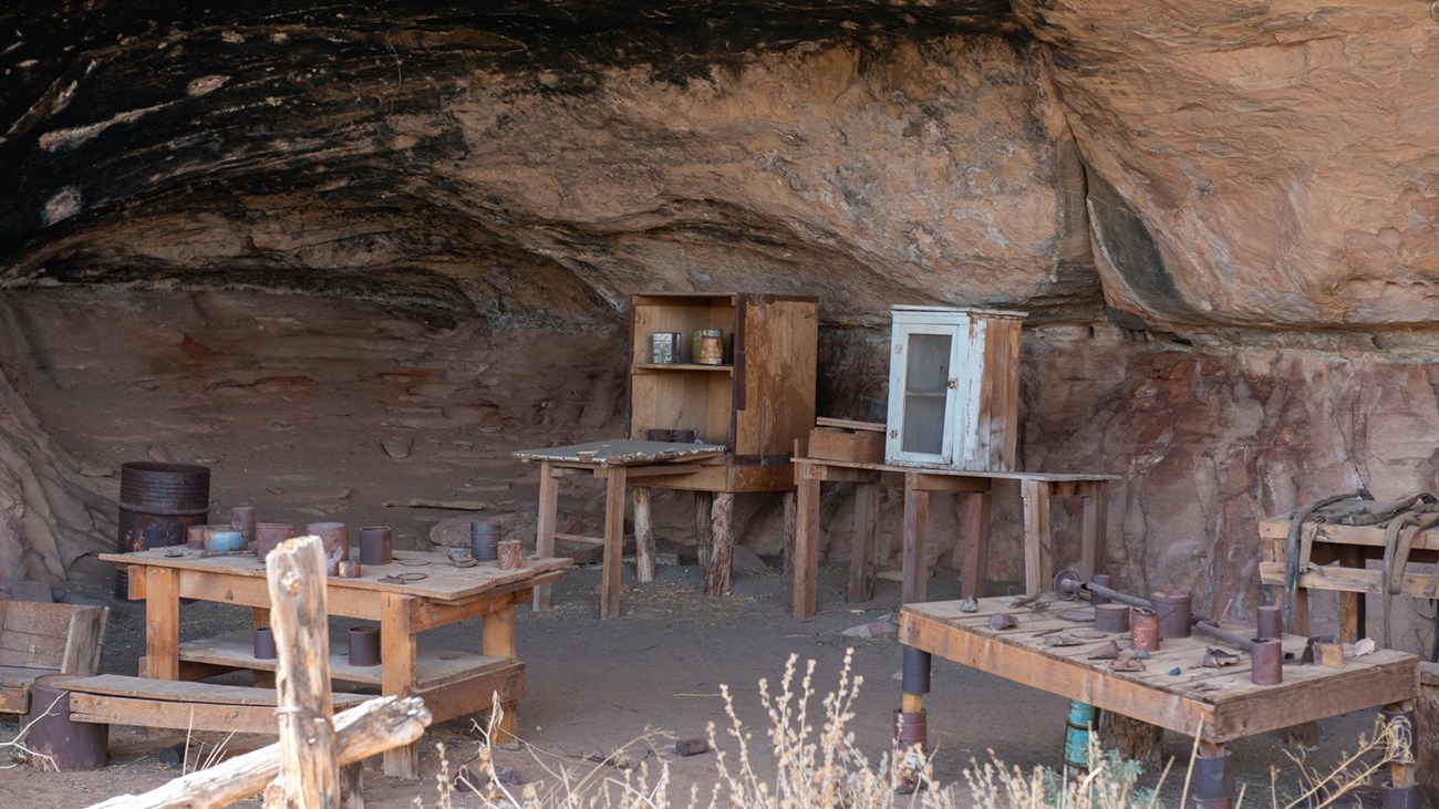
NPS photo by Neal Herbert.
Deep alcoves are common in Canyonlands National Park, particularly where more resistant rock units overlie softer rock units that erode more rapidly, creating deep overhangs. The Cave Springs alcove in the Needles District is a good example in the park of a deep overhang formed by sapping. Sapping are the processes that create alcoves by undercutting cap rocks, including those that occur at the location of springs or seeps. These alcoves and overhangs are not solution caverns, and would be considered pseudokarst.
Alcoves and overhangs are most common in the massive sandstone units in Canyonlands National Park, including the Cedar Mesa, White Rim, Wingate, and Navajo sandstones, or at their contacts with other layers.
Paleontological and archeological resources may be present in alcoves and overhangs in the park. Alcoves were used by prehistoric peoples and by cowboys prior to park establishment. Packrat middens are also common in alcoves and overhangs.
An evaluation of caves and karst programs and issues in national park sites identified 27.1% of Canyonlands National Park as potentially being karst based on the presence of limestone bedrock at the surface.
All NPS cave resources are protected under the Federal Cave Resources Protection Act of 1988 (FCRPA)(16 U.S.C. § 4301 et seq.).
Related Links
Other Geodiversity Values
The geologic significance of Canyonlands National Park is clearly identified by its park name. In addition to the park’s geomorphology, its geologic history and exceptionally well exposed rock record is of equal significance. Other geodiversity values of the park include its salt tectonic features, well-developed biological soil crusts, seeps and springs, and desert varnish and other rock surface coatings.
The salt tectonic features, particularly the Grabens in the Needles District, in the park have great scientific significance, and are the subject of ongoing research as well as providing educational opportunities for professional geologists and students.
Canyonlands National Park contains some of the best-developed biological soil crusts in the world. Biological soil crusts consist of communities of microorganisms including cyanobacteria, mosses, lichen, green algae, and microfungi, and bacteria and form in arid and semi-arid areas. They are integral to Canyonlands’ ecosystems because they fix nitrogen and provide other nutrients as well as inhibiting soil erosion. They develop well on the sandy soils found in the park.
Biological soil crust are very susceptible to crushing from human activities. Footprints, tire tracks from bicycles and vehicles can destroy crusts. The damage may take decades to repair and damaged crusts may never fully recover.
Protect soil crusts by staying on established roads and trails and protecting trailside vegetation and soils. When hiking off-trail, stay on bare slickrock or walk in dry washes where crusts do not form.
Springs and seeps along with the hanging gardens that they support are very important to the ecosystems of Canyonlands National Park because they are reliable water sources in a place where they are rare. The eolian sandstones of Canyonlands have high porosity and permeability. Springs may form where a less permeable layer causes water to flow laterally where it may emerge at the surface as a spring.
Like the nearby Arches National Park, Canyonlands contains an abundance of natural arches. They form on cliff edges and in narrow ridges (fins) where weathering and erosion forms an opening within the rock.Prominent natural arches in Canyonlands National Park include Mesa Arch and Musselman Arch in the Island in Sky District, and Druid Arch and Wooden Shoe Arch in the Needles District.
Stable sandstone surfaces in Canyonlands National Park are usually coated with a variety of thin rock coatings collectively known as desert varnish. Desert varnish consists clay minerals, heavy metal (iron and manganese) skins, silica glaze and other components. It may preferentially form where water streaks down cliff faces. In Canyonlands National Park, desert varnish is most noticeable on the White Rim and Navajo Sandstone where brown to black streaks make a stark visual contrast to the light-colored bedrock.
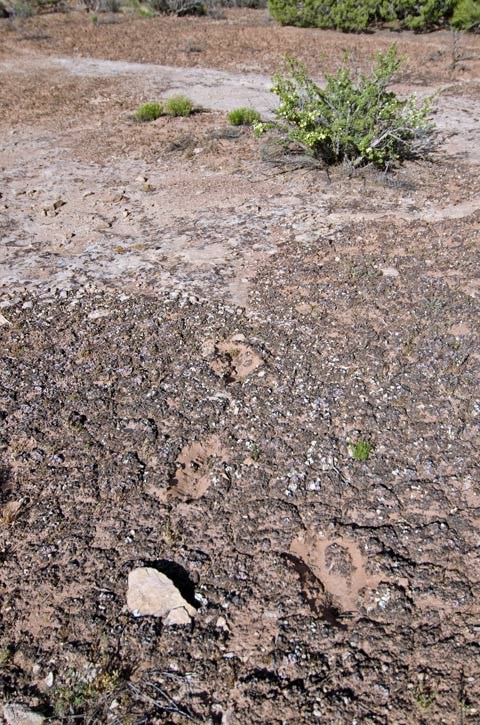
Damage to biological soil crust caused by foot prints.
NPS photo.

NPS photo by Neal Herbert.
Geohazards
Geohazards present in Canyonlands National Park include those associated with slope stability, rock fall and other mass wasting events, as well as flash flooding during intense rainfall events. Geohazards are also present at abandoned mineral lands, including radioactivity (including radon), unsafe structures, cave-ins, deadly gases and oxygen deficiency, and potentially unstable explosives.
Seismic Hazards
Overall, Canyonlands National Park has a moderate seismic hazard. The USGS 2014 Seismic Hazard Map indicates that the Canyonlands area has a 2% chance that earthquake peak ground acceleration of between 10 and 12 %g (percent of gravity) being exceeded in 50 years. This peak ground acceleration is roughly equivalent to VI on the Modified Mercalli Intensity Scale. The expected number of damaging earthquake shaking in the vicinity of Canyonlands National Park in 10,000 years is between 4 and 10.
Abandoned Mineral Lands
Canyonlands National Park contains extensive evidence of past mineral development, from both uranium mining and prospecting and oil and gas exploration.
Southeastern Utah where Canyonlands National Park is located has a rich history of uranium exploration and mining. The region was the center of the 1950s uranium boom, when US government incentives and rags-to-riches stories in popular media that told of prospectors who became millionaires overnight after discovering rich uranium deposits propelled widespread exploration for uranium deposits. Prospectors built roads, including the Island in the Sky’s Shafer Trail, staked claims, and developed small mines on lands that later became the park. Doghole mines were even worked by some miners after park establishment.
Most of the uranium prospecting that occurred on lands that later became Canyonlands National Park occurred in the Island in the Sky District because of the exposures of Chinle Formation there. The Chinle Formation is one of the two main uranium-bearing units in southeastern Utah, with some of the ore deposits being found in association with petrified wood. The Chinle Formation makes up the upper part of the slopes beneath the Island in the Sky cliffs. Numerous road scars and mining features are found throughout this layer.
Oil and gas development also occurred in Canyonlands National Park lands, again predominantly in the Island in the Sky district and along the river, particularly where anticlines provided likely sites to drill for hydrocarbons.
The National Park Service has inventoried 74 Abandoned Mineral Land (AML) features in Canyonlands National Park, including 24 AML sites, many requiring remediation.
NPS AML sites can be important cultural resources and habitat, but many pose risks to park visitors and wildlife, and degrade water quality, park landscapes, and physical and biological resources. Be safe near AML sites—Stay Out and Stay Alive!
Related Link
Burghardt, J. E., E. S. Norby, and H. S. Pranger, II. 2014. Abandoned mineral lands in the National Park System—comprehensive inventory and assessment. Natural Resource Technical Report NPS/NRSS/GRD/NRTR—2014/906. National Park Service, Fort Collins, Colorado. [PDF]
- Scoping summaries are records of scoping meetings where NPS staff and local geologists determined the park’s geologic mapping plan and what content should be included in the report.
- Digital geologic maps include files for viewing in GIS software, a guide to using the data, and a document with ancillary map information. Newer products also include data viewable in Google Earth and online map services.
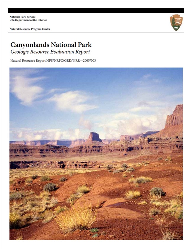
- Reports use the maps to discuss the park’s setting and significance, notable geologic features and processes, geologic resource management issues, and geologic history.
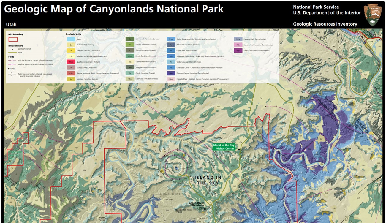
- Posters are a static view of the GIS data in PDF format. Newer posters include aerial imagery or shaded relief and other park information. They are also included with the reports.
- Projects list basic information about the program and all products available for a park.
Source: NPS DataStore Saved Search 2761. To search for additional information, visit the NPS DataStore.
A NPS Soil Resources Inventory project has been completed for Canyonlands National Park and can be found on the NPS Data Store.
Source: NPS DataStore Saved Search 2743. To search for additional information, visit the NPS DataStore.
Related Articles
Canyonlands National Park
National Park Service Geodiversity Atlas
The servicewide Geodiversity Atlas provides information on geoheritage and geodiversity resources and values within the National Park System. This information supports science-based geoconservation and interpretation in the NPS, as well as STEM education in schools, museums, and field camps. The NPS Geologic Resources Division and many parks work with National and International geoconservation communities to ensure that NPS abiotic resources are managed using the highest standards and best practices available.

