The Cascadia Subduction Zone and Southern Alaska are the sites of ongoing subduction as the Pacific and Juan de Fuca plates slide beneath the North American Plate. Some parks in the Sierra Nevada Mountains reveal igneous magma chamber rocks that represent the eroded remnants of an ancient subduction zone, when volcanoes similar to those found in the modern Cascade Mountains extended southward all the way through California.

Modified from “Parks and Plates: The Geology of our National Parks, Monuments and Seashores,” by Robert J. Lillie, New York, W. W. Norton and Company, 298 pp., 2005, www.amazon.com/dp/0134905172.
Subduction Zones—Active
- OLYM—Olympic National Park, Washington [Geodiversity Atlas] [Park Home]
- ORCA—Oregon Caves National Monument, Oregon [Geodiversity Atlas] [Park Home]
- REDW—Redwood National Park, California [Geodiversity Atlas] [Park Home]
-
KEFJ—Kenai Fjords National Park, Alaska—[Geodiversity Atlas] [Park Home]
-
CRLA—Crater Lake National Park, Oregon—[Geodiversity Atlas] [Park Home]
-
LAVO—Lassen Volcanic National Park, California—[Geodiversity Atlas] [Park Home]
-
MORA—Mount Rainier National Park, Washington—[Geodiversity Atlas] [Park Home]
-
ANIA—Aniakchak National Monument and Preserve, Alaska—[Geodiversity Atlas] [Park Home]
-
KATM—Katmai National Park, Alaska—[Geodiversity Atlas] [Park Home]
-
LACL—Lake Clark National Park, Alaska—[Geodiversity Atlas] [Park Home]
Subduction Zones—Ancient
- SEKI—Kings Canyon National Park, California—[Geodiversity Atlas] [Park Home]
- SEKI—Sequoia National Park, California—[Geodiversity Atlas] [Park Home]
- YOSE—Yosemite National Park, California—[Geodiversity Atlas] [Park Home]
Introduction
Subduction zones form where a plate with thinner (less-buoyant) oceanic crust descends beneath a plate with thicker (more-buoyant) continental crust. Two parallel mountain ranges commonly develop above such a subduction zone – a coastal range consisting of sedimentary strata and hard rock lifted out of the sea (accretionary wedge), and a volcanic range farther inland (volcanic arc). Ancient magma chamber rocks can be exposed if subduction stops and the volcanoes erode away.

Buoyancy
Where tectonic plates converge, the one with dense, thin oceanic crust subducts beneath the one with thick, more buoyant continental crust.
Subduction Zone—Two Parallel Mountain Ranges
- An accretionary wedge forms between the converging plates as material is scraped off the subducting plate.
- A forearc basin develops in the low area between the two mountain ranges.
- Farther inland, the subducting plate reaches depths where it “sweats” hot water. The rising water melts rock in its path, forming a volcanic arc on the overrriding plate.
- Near their boundary, the plates can lock together for centuries, then suddenly let go as a giant earthquake. If the seafloor rises or falls, giant sea waves (a tsunami) can form.

Cascadia Subduction Zone
- The Coast Range and Cascades are the two parallel mountain ranges that form the Cascadia Subduction Zone in the Pacific Northwest.
- The forearc basin is the Willamette Valley in Oregon and Puget Sound in Washington.

Images above modified from “Oregon's Island in the Sky: Geology Road Guide to Marys Peak, by Robert J. Lillie, Wells Creek Publishers, 75 pp., 2017, www.amazon.com/dp/1540611965.
Many National Park Service sites are found in active and ancient subduction zones. Visitors can witness mountains as they are forming, and sometimes experience the accompanying earthquake and volcanic activity. Parks in the Cascadia Subduction Zone dramatically display the two distinct mountain ranges – the Coast Range just above where the Juan de Fuca Plate begins to subduct, and the volcanic Cascade Range farther inland, where the top of the plate is deeper. Sites in the Sierra Nevada Mountains reveal the eroded roots of an ancient volcanic range that formed when the subduction zone extended much farther south. And very large parks in the Southern Alaska Subduction Zone display magnificent mountains, rock layers and active volcanoes that tell the story ongoing plate convergence along the North Pacific Coast.
Redwood National and State Parks, California

NPS photo.
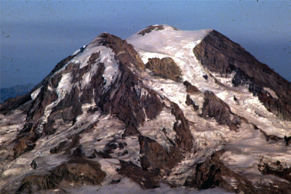
Mount Rainier National Park, Washington

Mount Rainier is a 14,000 foot (4,300 meter) volcano in the Cascade Range developed above the place where the subducting Juan de Fuca Plate reaches sufficient depth to release hot fluids into the overriding North American Plate.
Photo courtesy of Robert J. Lillie.
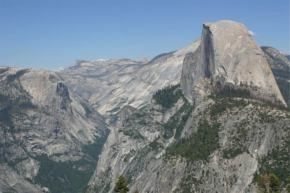
Yosemite National Park, California

Photo courtesy of Robert J. Lillie.
Kenai Fjords National Park, Alaska

Photo courtesy of Robert J. Lillie.
Cascadia Subduction Zone
The Pacific Northwest is an exciting place to observe geologic processes in action. National Park Service sites in the Coastal Ranges of Washington, Oregon and northern California contain rugged mountains of rocks that were manufactured in the ocean, then scraped off the plate and lifted out of the sea. But parks in the Cascade Mountains – within the same subduction zone – are dramatically different. They contain explosive volcanoes formed as fluids rise from the top of the subducting plate and generate magma as they melt their way to the surface. And as time ticks on, the region awaits sudden release of energy locked between the converging plates as a devastating earthquake.
The Cascadia Subduction Zone, extending from northern California through western Oregon and Washington to southern British Columbia, is a type of convergent plate boundary. Two parallel mountain ranges have been forming as a result of the Juan de Fuca Plate subducting beneath the edge of North America. Near the western edge of the continent, the Juan de Fuca Plate plunges downward and some of the layers of hard crust and ocean sediments are scraped off the top and squeezed upward as the Olympic Mountains and other coastal ranges. Farther east the Juan de Fuca Plate descends deeper and deeper. The rocks on top of the plate are metamorphosed due to the great temperatures and pressures at those depths. A by-product of the metamorphism is the release of hot fluids, especially water. The water rises and melts rock in its path. Some of the resulting magma makes it all the way to the surface and forms Mount Rainier, Mount Hood, Mount Shasta and other spectacular volcanoes of the Cascade Range. The low region between the two mountain ranges is the Puget Sound area of Washington and the Willamette Valley in Oregon.
The Cascadia Subduction Zone is the Region where the Juan De Fuca and North American Plates Converge
- The Coast Ranges, including the Olympic Mountains, are made of oceanic sediments and hard rocks that were caught in the vise between the converging plates, uplifted, and added to the edge of the continent.
- Puget Sound and the Willamette Valley are areas near sea level between the coastal and volcanic mountain ranges.
- The Cascades form above the line where the subducting plate extends to depths where it heats up, dehydrates and causes magma to form. The line of active volcanoes, from Mt. Garibaldi to Lassen Peak, coincides with the north-to-south extent of the subducting plate boundary.

Modified from “Beauty from the Beast: Plate Tectonics and the Landscapes of the Pacific Northwest,” by Robert J. Lillie, Wells Creek Publishers, 92 pp., 2015, www.amazon.com/dp/1512211893.
Topography of the Cascadia Subduction Zone

- The Coastal Mountain Ranges, including the Olympic Mountains in northwest Washington and the Coast Range in southwest Washington, western Oregon and northwest California, form as sedimentary and volcanic layers are scraped off the top of the subducting oceanic plate and added to the edge of the continent.
- The low region between the two parallel mountain ranges is the Puget Sound area in Washington, the Willamette Valley in Oregon and the Great Valley in northern California.
- 150 miles inland, the top of the subducting plate reaches depths where it’s hot enough to generate fluids, forming volcanoes in the Cascades.
The Cascadia Subduction Zone has two parallel mountain ranges separated by a low region near sea level.
Modified from “Oregon's Island in the Sky: Geology Road Guide to Marys Peak, by Robert J. Lillie, Wells Creek Publishers, 75 pp., 2017, www.amazon.com/dp/1540611965.
The two parallel mountain ranges influence many of the physical and cultural aspects of the Pacific Northwest. Storms coming in from the Pacific Ocean drop most of their moisture on the Coast Range and Cascades, leaving eastern Oregon and Washington high and dry. This affects not only plant and animal communities, but also human habitation and land use. The physical landscape was an important component of the practical and spiritual aspects of Native Americans’ lives. Later, most of the settlers coming on the Oregon Trail continued past central Oregon and Washington to the lush farmland of the Willamette Valley and Puget Sound, the low-lying region between the two rising mountain ranges.
Cascadia Subduction Zone: Topography, Earthquakes and Volcanic Eruptions

Modified from “Oregon's Island in the Sky: Geology Road Guide to Marys Peak, by Robert J. Lillie, Wells Creek Publishers, 75 pp., 2017, www.amazon.com/dp/1540611965.
Subduction in the Pacific Northwest creates incredible beauty in the form of coastlines, mountains, and valleys—iconic features of the many National Park Service sites in the region. This beauty is part of the reason that residents and visitors have learned to tolerate, and develop ways to mitigate, the effects of earthquakes, tsunamis and volcanic eruptions—beasts that are consequences of the same tectonic forces that create the region’s beauty. Individual earthquakes can offset or lift the land a fraction of an inch or a few inches (centimeters) at a time. That may not seem like much, but when tens of thousands of earthquakes occur over a few million years, coastal ranges form. Likewise, individual volcanic eruptions may add only a thin layer to the surface. But thousands of eruptions over less than a million years have built Mount Rainier and other Cascade peaks to elevations of more than 10,000 feet (3,000 meters)!
A variety of earthquakes shake the Pacific Northwest due to plate-tectonic activity. The largest (locked zone earthquakes) occur where the Juan de Fuca and North American plates are stuck together, as they have been for the past three centuries. When the plates suddenly let go, a massive earthquake will shake the entire Pacific Northwest, a series of tsunami waves will pound the Coast, and landslides will make it difficult to reach some of those in need. These mega-earthquakes occur every 200 to 600 years or so, and the last one was in the year 1700. Visits to coastal NPS sites in the Pacific Northwest can help us appreciate the landscapes that develop over time because of these large quakes, and learn how we are preparing our homes, communities, and infrastructure for the next “Big One.”
Coast Range
The Coast Range (including the Olympic Mountains) consists of sedimentary rock layers and hard crust scraped off the ocean floor where the Juan de Fuca Plate begins to dive downward. The grinding action also produces devastating earthquakes, including some that result in giant tsunami waves.
Forming the Coast Range

Olympic National Park, Washington
Tilted layers of thick sandstone (pink) and thin shale (dark) along the coast at Olympic National Park reveal the enormous forces that lifted and deformed the oceanic layers as the Juan de Fuca and North American plates converged.
Photo courtesy of Robert J. Lillie.

Ranger Jen’s Oreo Demo
Jennifer Natoli was a seasonal ranger at Redwood National and State Parks in California. In her version of the Oreo® cookie demonstration, the creamy filling is the layers of sediment and basalt on the ocean floor. As the Juan de Fuca Plate (lower cookie) subducts beneath the North American Plate (upper cookie), the layers are scraped off the ocean floor and pile up as the Coast Range.
Modified from “Beauty from the Beast: Plate Tectonics and the Landscapes of the Pacific Northwest,” by Robert J. Lillie, Wells Creek Publishers, 92 pp., 2015, www.amazon.com/dp/1512211893.
Earthquakes Build Dramatic Coastal Landscapes
Visitors to Olympic National Park, Oregon Caves National Monument, or Redwood National and State Parks can look down and imagine the top of the Juan de Fuca Plate about 10 miles (16 kilometers) beneath their feet. This is the zone where the two plates have been locked together since the last great earthquake occurred in the year 1700. A sudden unlocking could produce an earthquake every bit as big as the one that occurred in Alaska in 1964, when a similar subduction zone boundary snap occurred.

Copalis River, Washington
Trees along the Washington coast were killed by salt-water invasion when the land suddenly dropped during the last great Cascadia Subduction Zone earthquake in the year 1700.
USGS photo.

Olympic National Park, Washington
The same forces that shift the land so dramatically also gradually build spectacular landscapes like the coastlines of the Pacific Northwest.
Photo courtesy of Robert J. Lillie.

Redwood National and State Parks, California
NPS photo.
Some geological processes act so slowly that we may think of the Earth as rock-solid and unmoving. But given enough time, the Coast Ranges lift up distances we can measure, while at the same time wind, rain, and the pounding of waves wear the landscape back down. Pillow lavas form on the ocean floor where erupting magma encounters cold sea water. When caught between the converging Juan de Fuca and North American plates, the pillows and other ocean layers can be lifted upward to more than a mile above sea level. Layers of sand and mud, deposited on the ocean floor and later turned into the sedimentary rocks sandstone and shale, are seen above the pillows. Dramatic examples of these layers in tilted and contorted forms can be found in Olympic National Park and elsewhere along the coast and in the mountains. This contortion attests to the great forces that squeezed and lifted the layers from the sea.
A visit to Olympic National Park is an opportunity to witness features of an accretionary wedge as they develop. Igneous, sedimentary, and metamorphic rocks are all found in abundance. Most of the igneous rocks were manufactured in the ocean and are basalt. The spectacular pillow lavas seen on the road up Hurricane Ridge indicate that lava formed on the sea floor and was later uplifted. Basalt lava is thin and runny and will flow for miles and miles. But if the lava spills out from beneath the ocean, it encounters cold water and hardens quickly as a pile of pillows. Most of the sedimentary rocks formed from layers of sand and mud deposited in the ocean. As they were caught in the vise between the converging Juan de Fuca and North American plates, some of the layers were so contorted that they are now in vertical orientations along the coast. Other rocks seen in the high mountains at the center of the park were pushed more deeply into the Earth, where increasing temperature and pressure changed them into metamorphic rocks known as quartzite and slate.
Formation of Pillow Basalt
Layers of pillow basalt exposed at NPS sites in the Coastal Ranges are evidence that lava flows that formed in the Pacific Ocean were later scraped off the subducting plate and lifted upward as part of the accretionary wedge.

Pillow basalt layers formed more than a mile (1.6 kilometers) below the surface of the ocean are now almost a mile above sea-level on Hurricane Ridge Road in Olympic National Park, Washington.
Photo courtesy of Robert J. Lillie.

As fluid basalt lava flows into the ocean it forms a pile of globular structures known as pillows.
Modified from “Earth: Portrait of a Planet", by S. Marshak, 2001, W. W. Norton & Comp., New York.
Cascade Volcanoes
The Cascade Volcanoes extend in a north-south line from Mt. Garibaldi in southern British Columbia, through Washington and Oregon, to Lassen Peak in northern California. The volcanoes are forming above the region where the top of the subducting Juan de Fuca Plate reaches about 50 miles (80 kilometers) depth. Increased temperature and pressure at that depth cause the rocks to metamorphose and dehydrate (”sweat”). The rising hot water causes overlying rock to melt, generating magma that at times erupts out on the surface as lava flows and other materials forming Mt. Rainier in Washington, Mt. Hood in Oregon, Mt. Shasta in California, and other Cascade Volcanoes.
The initial magma formed as mantle rock melts beneath a subduction zone has low silica (basalt) composition. As the basalt magma rises up through the thick continental crust of North America, it melts some of that rock, too. In doing so the magma is enriched in silica, because high-silica minerals commonly are the first ones to melt. The resulting magmas can therefore have a variety of compositions, ranging from the original (low-silica) basalt, to (intermediate-silica) andesite, all the way up to (high-silica) rhyolite. Solids and gases are also part of the mix.
Magmas high in silica are thick and pasty. Gases may be trapped in them under high pressure. Thus subduction-zone volcanoes—including those in the Cascades—can be explosive (think of the release of steam in a boiling pot of thick oatmeal). Their high-silica magmas produce not only andesite and rhyolite lava flows, but also lots of other volcanic materials such as ash and pumice. When mixed with water from glaciers, snowmelt, and streams, these materials can make very dense, fast-moving volcanic mudflows (known sometimes by the Indonesian term “lahar”). And at times, lower-silica components of their magma chambers erupt, producing basalt lava flows as well as cinders and volcanic bombs.
NPS Volcanic Sites in the Cascades
National Park Service sites in the Cascades reveal colorful landscapes that result from a varity of volcanic processes.
Mt. Rainier National Park, Washington

Photo courtesy of Robert J. Lillie.
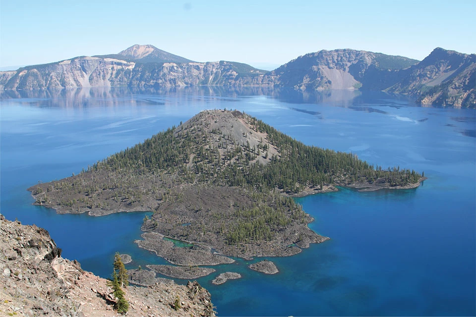
Crater Lake National Park, Oregon

Photo courtesy of Robert J. Lillie.
Lassen Volcanic National Park, California

Photo courtesy of Robert J. Lillie.
Volcanoes in national parks in the Cascades have eruptive “personalities” that reflect the complex magma systems associated with subduction zones. Mount Rainier National Park showcases a 14,411-foot (4,393-meter) composite volcano. The mountain is mainly andesite lava flows and volcanic mudflows covered by numerous glaciers. Crater Lake National Park has the 9th deepest lake in the world. The lake partially fills a collapsed crater (“caldera”) that formed when a 12,000-foot (3,700-meter) composite volcano, Mt. Mazama, violently erupted 7,700 years ago. Lassen Peak in Lassen Volcanic National Park is an amalgamation of rhyolite lava domes. A series of explosions and ash clouds from the peak between 1914 and 1921 represents the last large volcanic eruption within the lower 48 states prior to Washington’s Mt. St. Helens in 1980. Hydrothermal features on the flanks of Lassen Peak include numerous hot springs, mudpots and fumaroles that suggest there is still hot magma beneath the mountain.
Formation of Crater Lake
Crater Lake partially fills the caldera of a volcano that erupted and collapsed in on Itself 7,700 years ago.


Illustrations above modified from “Beauty from the Beast: Plate Tectonics and the Landscapes of the Pacific Northwest,” by Robert J. Lillie, Wells Creek Publishers, 92 pp., 2015, www.amazon.com/dp/1512211893.
Ancient Subduction in the Sierra Nevada
A glance at a map of the western United States might suggest that the Sierra Nevada are a southward continuation of the Cascade Volcanoes. In the past, that was true. About 200 million years ago a large tectonic plate (called the Farallon Plate) started to subduct beneath the western edge of North America. The subduction formed a line of volcanoes stretching all the way from Alaska to Central America. Beginning about 30 million years ago, so much of the Farallon Plate was consumed by subduction that the Pacific and North American plates were in contact, forming the San Andreas transform plate boundary in western California. Over time, the San Andreas boundary has grown longer as the Farallon Plate split into two separate plates—the Juan de Fuca Plate on the north, and the Cocos Plate on the south.
West Coast Tectonic Evolution
Granite rocks found in national parks in the Sierra Nevada are the cooled and eroded remnants of magma chambers that fed ancient subduction zone volcanoes in California.

40 Million Years Ago
Forty million years ago, a large tectonic plate, known as the Farallon Plate, was between the Pacific and North American plates. Subduction of the Farallon Plate beneath the entire West Coast created a line of volcanoes from Alaska to Central America.

20 Million Years Ago
As the mid-ocean ridge separating the Farallon and Pacific Plates entered the subduction zone, the Farallon Plate separated into the Juan de Fuca and Cocos Plates. A transform plate boundary developed where the Pacific Plate was in contact with the North American Plate and the volcanism ceased in central California. Farther east, the continent began to rift apart in the Basin and Range Province.

Today
The Cascades are the modern volcanic arc developing where the Juan de Fuca Plate subducts beneath the North American Plate. The Sierra Nevada are the eroded remnants of the volcanic arc developed when the Farallon Plate subducted beneath the continent. The San Andreas Fault and Queen Charlotte Fault are transform plate boundaries developing where the Pacific Plate moves northward past the North American Plate.
Illustrations above modified from “Earth: Portrait of a Planet", by S. Marshak, 2001, W. W. Norton & Comp., New York.
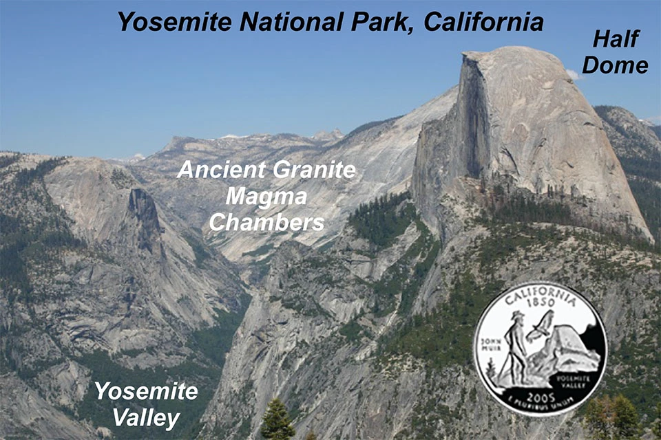
In central and southern California the ancient volcanoes have largely eroded away. Massive areas of granite from the cooled magma chambers that fed the volcanoes form portions of the Sierra Nevada Mountains, including Yosemite National Park.
Cascade - Sierra Volcanic Connection

The Sierra Nevada are a remnant of volcanoes that extended southward when the ancient Farallon Plate dove beneath the edge of North America. The Coast Range (accretionary wedge), Great Valley (forearc basin), and Sierra Nevada (volcanic arc) still reflect the subduction zone topography. Rocks in Yosemite, Kings Canyon, Sequoia, and Joshua Tree national parks contain exumed magma chamber rock that formed beneath the ancient volcanoes. National Park Service sites are shown in red. Four-letter codes indicate the ancient volcanic arc parks listed near the top of this page.
Modified from “The Geology of our National Parks, Monuments and Seashores,” by Robert J. Lillie, New York, W. W. Norton and Company, 298 pp., 2005, www.amazon.com/dp/0134905172.
Ancient Subduction Zone

Modified from “The Geology of our National Parks, Monuments and Seashores,” by Robert J. Lillie, New York, W. W. Norton and Company, 298 pp., 2005, www.amazon.com/dp/0134905172.
State Quarters of West Coast National Parks Represent Modern and Ancient Volcanic Landscapes
State quarters can be used to demonstrate the current and ancient volcanic landscapes of the Pacific Northwest and California. From 1999 to 2008, the United States Mint issued 25-cent coins representing each of the 50 states. These quarters featured iconic images that have special meaning to each state. Not surprisingly, many of the engravings depict landscapes of national parks. The three West Coast states are especially meaningful because they have geologic features that, when the quarters are stacked, represent the surface and subsurface of the chain of volcanoes that has been developing over the past 200 million years. This can be demonstrated by stacking the three quarters with California on the bottom, overlain by Oregon and then Washington.
Washington
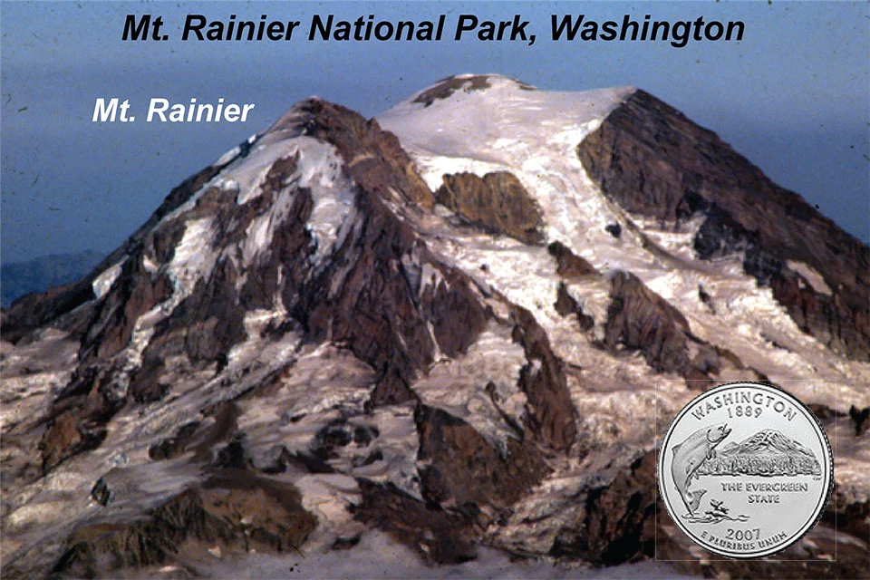
Left image
Mount Rainier.
Credit: Photo Courtesy of Robert J. Lillie.
Right image
Feature labels. (Click on arrows and slide left and right to see labels.)
Oregon
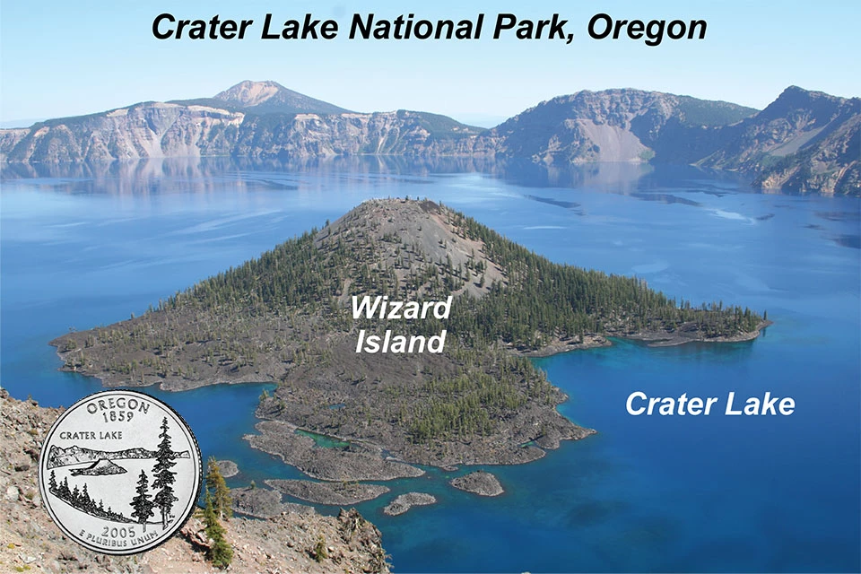
Left image
Feature labels. (Click on arrows and slide left and right to see labels.)
Right image
Crater Lake.
Credit: Photo courtesy of Robert J. Lillie.
California
Left image
Yosemite Valley and Half Dome.
Credit: Photo Courtesy of Robert J. Lillie.
Right image
Feature labels. (Click on arrows and slide left and right to see labels.)
Stack the quarters with Washington on top, Oregon in the middle and California on the bottom. Looking first at Washington, one sees Mt. Rainier, a composite volcano rising to over 14,000 feet above sea level in Mt. Rainier National Park. Imagine if Mt. Rainier were to suddenly and violently erupt—so much that its magma chamber empties and the volcanic peak collapses in on itself. Remove the Washington quarter and you can see what the landscape might look like, in the form of Crater Lake in Crater Lake National Park in Oregon. An ancient volcano, Mt. Mazama, erupted and collapsed 7,700 years ago, forming the large cavity (caldera) that now holds Crater Lake. Now suppose the subduction processes that form the volcanoes were to stop, shutting off the magma supply that feeds the volcanoes. With continued uplift and erosion, most of the volcanic material would erode. Remove the Oregon quarter to reveal cooled magma chamber rocks below. This is what has happened in the Sierra Nevada of central and southern California, as represented by the granite-type rocks of Half Dome within Yosemite National Park shown on the California state quarter.
Southern Alaska Subduction Zone
Five park sites in southern Alaska showcase landscapes formed by the subduction of the northward-moving Pacific Plate beneath North America. One of them, Kenai Fjords National Park, lies within the accretionary wedge of uplifting oceanic sedimentary strata and hard crust. Three others, Aniakchak National Monument, Katmai National Park, and Lake Clark National Park, are farther inland, along the active volcanic arc. Another, Wrangell-St. Elias National Park, is a vast region that extends across the accretionary wedge and volcanic arc, and is built of accreted terranes.
National Park Service Sites in Alaska Subduction Zone

Modified from “Parks and Plates: The Geology of our National Parks, Monuments and Seashores,” by Robert J. Lillie, New York, W. W. Norton and Company, 298 pp., 2005, www.amazon.com/dp/0134905172.
Southern Alaska Subduction Zone

Modified from “Parks and Plates: The Geology of our National Parks, Monuments and Seashores,” by Robert J. Lillie, New York, W. W. Norton and Company, 298 pp., 2005, www.amazon.com/dp/0134905172.
Accretionary Wedge
Kenai Fjords National Park lies within a coastal mountain range (accretionary wedge) formed as the Pacific Plate subducts beneath southern Alaska. Pillow basalts attest to the oceanic origins of the rock layers, as they formed from lava flows that cooled on the ocean floor. Sandstone and shale layers at Kenai Fjords are commonly metamorphosed and were so deformed during subduction and uplift that they are vertical in places. The park is right above the focus of the Great Alaska Earthquake of 1964, one of the two largest ever recorded (the other, in 1961, occurred along the subduction zone off western South America). Effects of the 1964 earthquake are quite spectacular in the park; the coastline dropped so much that in places it lies submerged beneath about 8 feet (2.5 meters) of water.
Accretionary Wedge in Southern Alaska
Volcanic and metamorphic rocks exposed in Kenai Fjords National Park reveal the incredible forces that occur at an ocean/continent subduction zone.

Kenai Fjords National Park
Layers of sandstone and shale deposited on the top of the Pacific Plate were later metamorphosed to quartzite and slate as the plate subducted beneath southern Alaska, and then shoved upward as part of the accretionary wedge.
Photo courtesy of Robert J. Lillie.

Kenai Fjords National Park
Sea lions resting on layers of pillow basalt that formed beneath the ocean and were uplifted as part of the accretionary wedge.
Photo courtesy of Robert J. Lillie.
Volcanic Arc
More than 40 volcanoes have erupted in Alaska since Russians first arrived in the mid 1700s – a great many of the volcanoes are in areas that are now National Park Service sites. They are part of the volcanic arc that extends northeastward from the Aleutian Islands, across the Alaska Peninsula and Aniakchak National Monument, Katmai and Lake Clark national parks, and then bends eastward to Wrangell-St. Elias National Park.
Volcanic Arc Features in Southern Alaska
National Park Service Sites in the Southern Alaska Subduction Zone reveal a variety of active volcanic features above the zone where the top of the Pacific Plate reaches sufficient depth where temperature and pressure are high enough to dehydrate rocks and form magma.
Active Volcanoes

Lake Clark National Park
Redoubt Volcano
USGS photo.

Wrangell–St. Elias National Park
Mt. Wrangell (left) and Mt. Drum (right).
USGS photo.
Collapse Calderas

Aniakchak National Monument
NPS photo.

Katmai National Park
USGS photo.
Lava Domes

Katmai National Park
Novarupta Lava Dome
USGS photo.

Lake Clark National Park
USGS photo.
Aniakchak National Monument and Preserve is on the Alaska Peninsula. The eruption of Aniakchak Volcano about 3,500 years ago rivals the eruption and collapse of Mt. Mazama that formed Crater Lake. The original composite volcano was about 7,000 feet (2,000 meters) high, but lost about 2,500 feet (750 meters) of its height. The 6-mile (10-kilometer) wide caldera is about 2,000 feet (600 meters) deep. Like Mt. Mazama, Aniakchak spewed lava across its caldera floor for centuries after its collapse. The volcano is still active, having erupted in 1931. But unlike Mt. Mazama, Aniakchak no longer holds a large lake because the caldera wall is breached.
Katmai National Park and Preserve lies where the world’s largest volcanic event of the 20th Century occurred. In 1912 the Katmai region erupted an estimated 7 cubic miles (30 cubic kilometers) of ash and pyroclastic material, roughly 50 times the amount that came out of Washington’s Mt. St. Helens in 1980. The collapse caldera from the Katmai eruption is about 3 miles (5 kilometers) across and 2,000 feet (600 meters) deep. The caldera has partially filled with water – an approximately half-scale version of the better-known Crater Lake in Oregon. Katmai volcano did collapse, but unlike Mt. Mazama 7,700 years before, the material expelled from its magma chamber did not spew forth out of the top of the volcano. Rather, it flowed underground to a vent 6 miles (10 kilometers) away! The vent was the source for most of the ash and pyroclastic flows expelled during the 1912 eruptions, and has since filled with a lava dome known as Novarupta.
At 20,625 square miles (53,396 square kilometers), Wrangell – St. Elias National Park and Preserve is the largest U. S. national park – six times the size of Yellowstone. The park is a complex amalgamation of blocks of continental and oceanic crust that have slammed into North America. Poking through the mass of some of the highest mountains in North America are very young volcanoes formed by the ongoing Pacific Plate subduction. Among them are Mt. Wrangell, a 14,163 foot (4,317 meter) volcano that last erupted during the early part of the 20th Century.
Lake Clark National Park and Preserve contains an active composite volcano with a profile and recent history reminiscent of Mt. St. Helens. In 1989 and 1990, Mt. Redoubt, on the eastern side of the park, had four explosive eruptions that resulted in large volumes of ash and mudflows. And, as at Mt. St. Helens, a lava dome later grew within the breached crater near the mountain’s summit.
Volcano Monitoring in National Parks
The eruption of Mt. Redoubt, an active volcano in Lake Clark National Park, illustrates how a volcano can pose an unexpected hazard in our modern age – and why monitoring volcanic activity is so important (see photo below). On Dec. 15, 1989 a jet with 244 passengers and crew was en route from Amsterdam to Anchorage. Without warning the plane flew right through the eruption cloud at 25,000 feet (7,500 meters) altitude. Silica-rich ash melted and coated the hot engine turbines with glass, causing all four of them to shut down. After a terrifying free-fall that lasted 8 minutes, the pilots finally managed to restart the engines at only 6,000 feet (2,000 meters). Fortunately, no one was injured. But the incident highlighted the importance of monitoring volcanic activity and making the information immediately available to the airline industry and other segments of the public.

USGS photo.
Figures Used
Related Links
Site Index & Credits
Plate Tectonics and Our National Parks
- Plate Tectonics—The Unifying Theory of Geology
- Inner Earth Model
- Evidence of Plate Motions
- Types of Plate Boundaries
- Tectonic Settings of NPS Sites—Master List
Teaching Resources—Plate Tectonics
Photos and Multimedia—Plate Tectonics
Geological Monitoring—Plate Tectonics
Plate Tectonics and Our National Parks (2020)
-
Text and Illustrations by Robert J. Lillie, Emeritus Professor of Geosciences, Oregon State University [E-mail]
-
Produced under a Cooperative Agreement for earth science education between the National Park Service's Geologic Resources Division and the American Geosciences Institute.
Last updated: February 11, 2020