Introduction
Plate tectonics has revolutionized the way we view large features on the surface of the Earth. Earth’s internal processes were previously thought to operate in a vertical fashion, with continents, oceans, and mountain ranges bobbing up and down, without much sideways movement. But the acceptance of continental drift and other evidence for large lateral motions changed all that. Now it’s understood that Earth’s internal processes can move large plates of Earth’s outer shell great horizontal distances. Plate tectonics thus provides “the big picture” of geology; it explains how mountain ranges, earthquakes, volcanoes, shorelines, and other features tend to form where the moving plates interact along their boundaries.
Continental Drift and the Development of Plate Tectonic Theory
Ever since the first maps of the Atlantic Ocean were made in the 16th Century people noticed how Africa and South America fit together like pieces of a giant jigsaw puzzle. The fit is even more impressive if the continents are joined together along the edges of their continental shelves. The resulting landmass, called Pangea, represents a glimpse in time, about 250 million years ago, when most of the continental crust happened to be joined together. Prior to that time the continents were apart; since then they have drifted away from one another (imagine bumper cars being stuck together for a while, then flying apart!). This theory, called continental drift, was viewed with skepticism in the early 20th Century. It was thought impossible for blocks of crust to plow their way over Earth’s mantle, which was known to be far more rigid and dense.
The idea of continental drift, inspired by the observation that the continents fit together like picies of a giant jigsaw puzzle, provided strong evidence for the theory that later developed as plate tectonics.

-
Relatively thick crust of the continents includes not only regions above sea level (orange), but also the continental shelves (dark blue) that lie beneath shallow water.

- Blocks of thick continental crust fit together nicely along the edges of their shelves to form the supercontinent called Pangea.
Figures above modified from “Physical Geology,” by B. J. Skinner and S. C. Porter, John Wiley and Sons, Inc., New York, 1987.
Observations that led to the Development of Plate Tectonic Theory
Two scientific advances in the mid-20th Century resulted in information critical to acceptance of continental drift and plate tectonic theory. First, the topography of the ocean floor was mapped in great detail during and after World War II. It was discovered that the floors of the ocean basins are not flat. A continuous mountain chain circumscribes the globe near the centers of oceans and, in places, the ocean floor descends abruptly into deep-sea trenches. Second, a network of seismographs was installed around the world in the early 1960s, to detect nuclear tests during the Cold War. As a result geologists could more precisely locate earthquakes and map the speed of seismic waves passing through various regions of the Earth.

From “World Ocean Floor Map,” by Bruce C. Heezen and Marie Thorpe. 1977
Seafloor Topography
Continents fit together along the edges of their continental shelves. Mid-ocean ridges and deep-sea trenches develop at the boundaries of the moving plates. Volcanic islands and seamounts develop where a plate moves over a stationary hotspot.
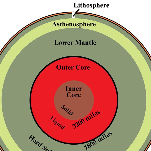
The new earthquake data revealed three startling observations. First, earthquakes are not scattered throughout the oceans, but instead are confined to narrow, rather continuous bands. The narrow zones of earthquakes outline the boundaries of moving plates. Second, only shallow earthquakes (less than 40 miles; 70 kilometers deep) occur where plates diverge along mid-ocean ridges, while earthquakes at deep-sea trenches extend downward to as deep as 400 miles (700 kilometers) where plates converge. Finally, seismic waves slow down as they travel through a zone about 100 to 400 miles (150 to 700 kilometers) deep, a sign that there is a relatively soft layer within Earth’s mantle. This last observation is the “Rosetta Stone” for plate tectonic theory. It provides a means by which continents can drift apart. Instead of plowing directly over mantle, the continents are “passengers” on the tops of much thicker plates. The plates of crust and stiff mantle (lithosphere) move on the softer mantle layer beneath (asthenosphere).

Modified from “Parks and Plates: The Geology of our National Parks, Monuments and Seashores,” by Robert J. Lillie, New York, W. W. Norton and Company, 298 pp., 2005, www.amazon.com/dp/0134905172.
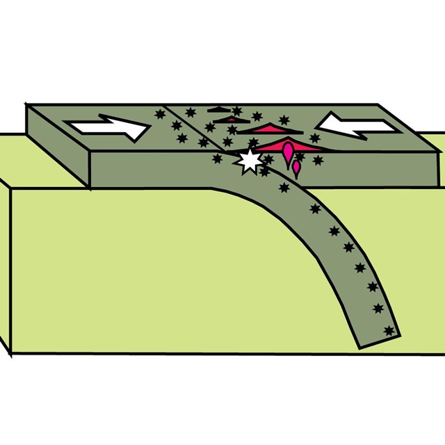
Earthquake and Volcanic Activity
Most earthquakes and volcanoes occur where the moving plates interact along their boundaries, and at hotspots.
Evidence for Tectonic Plates
The continents are blocks of thick crust that are passengers on the tops of large tectonic plates (lithosphere) that move over a softer part of Earth’s mantle (asthenosphere). Earthquakes, mountain building and volcanic activity occur mostly at the boundaries of the moving plates. Only shallow earthquakes occur where plates diverge at mid-ocean ridges, whereas earthquakes extend to great depth where plates converge at subduction zones.

Modified from “Parks and Plates: The Geology of our National Parks, Monuments and Seashores,” by Robert J. Lillie, New York, W. W. Norton and Company, 298 pp., 2005, www.amazon.com/dp/0134905172.
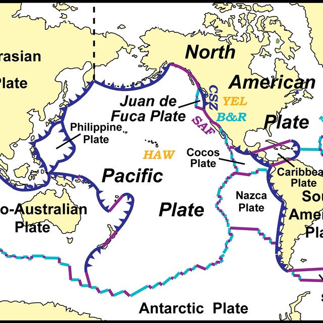
Earth's Tectonic Plates
Below is a map of the tectonic plates of the earth. The Earth has a dozen or so major plates and several minor plates.

Modified from: R.J. Lillie. 2005. Parks and Plates.
Geoscience Concepts—Plate Tectonics
Figures Used
Related Links
Site Index & Credits
Plate Tectonics and Our National Parks
- Plate Tectonics—The Unifying Theory of Geology
- Inner Earth Model
- Evidence of Plate Motions
- Types of Plate Boundaries
- Tectonic Settings of NPS Sites—Master List
Teaching Resources—Plate Tectonics
Photos and Multimedia—Plate Tectonics
Geological Monitoring—Plate Tectonics
Plate Tectonics and Our National Parks (2020)
-
Text and Illustrations by Robert J. Lillie, Emeritus Professor of Geosciences, Oregon State University [E-mail]
-
Produced under a Cooperative Agreement for earth science education between the National Park Service's Geologic Resources Division and the American Geosciences Institute.
Last updated: February 11, 2020