
NPS photo/Ann Wildermuth
The Basin and Range province is familiar to anyone lucky enough to venture across it. Steep climbs up mountain ranges alternated with long treks across flat basins. This pattern extends from eastern California to central Utah and from southern Idaho to the state of Sonora in Mexico.
Within the province, the Earth's crust (and upper mantle) has been stretched up to 100% of its original width. As it expanded, the crust thinned and cracked, creating large faults. Along the trending faults, mountains were pushed up, and valleys carved below creating a distinctive alternating pattern of ranges and valleys.
The topography and the dry climate create a number of impressive features and landscapes. These include pediments, alluvial fans, bajadas, bolsons, Inselbergs, playas, mud flats, salt flats, lakes, sand dunes, canyons and the Rio Grande Rift.
The vast region of the Basin and Range is divided into five distinct sections:
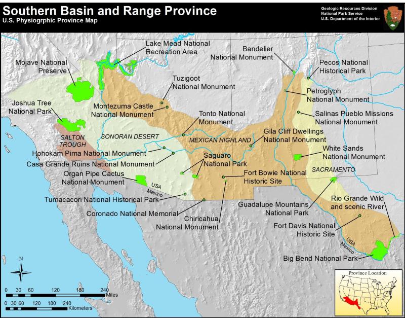
- Great Basin
- Sonoran Desert
- Salton Trough
- Mexican Highland
- Sacramento
Physiographic Province Maps
The Great Basin Section comprises the entire northern portion of the Basin and Range province. This section contains a portion of southwestern Oregon, southeastern Idaho, the western portion of Utah and nearly the entire state of Nevada. This section is notable for its function as a "Great Basin", in that virtually no ground water escapes to the oceans.
The Southern Basin and Range consists of the Sonoran Desert, Salton Trough, Mexican Highland, and the Sacramento sections. This portion of the province mountains have a slightly lower elevation than those found in the northern part of the province.
Return to Physiographic Provinces

NPS Photo / Dale Pate
Educational Resources
- Basin and Range Animations
The Incorporated Research Institutions for Seismology (IRIS) has created an interactive animation and many video animations demonstrating the processes that form the Basin and Range. A worksheet to accompany the animations provides background information and vocabulary for students. Learn more on the IRIS website. - Basin and Range Faulting
In this activity from the Incorporated Research Institutions for Seismology (IRIS), students study geologic cross sections to determine the differences between normal faults and thrust faults and then try to piece together the fault lines. - How to Make a Mountain
Learn how to make fault-block mountains. Students will understand the geologic forces that form and shape mountains, and more. Read the curriculum on the teachingboxes.org website. - Geologic History of Lake Mead Recreational Area
Learn more about the geologic history of Lake Mead on the from USGS.
Basin and Range Parks
- Big Bend National Park, Texas—[Geodiversity Atlas] [Park Home]
- Casa Grande Ruins National Monument, Arizona—[Geodiversity Atlas] [Park Home]
- Chamizal National Memorial, Texas—[Geodiversity Atlas] [Park Home]
- Chiricachua National Monument, Arizona—[Geodiversity Atlas] [Park Home]
- City of Rocks National Reserve, Idaho—[Geodiversity Atlas] [Park Home]
- Coronado National Memorial, Arizona—[Geodiversity Atlas] [Park Home]
- Death Valley National Park, California, Nevada—[Geodiversity Atlas] [Park Home]
- Fort Bowie National Historic Site, Arizona—[Geodiversity Atlas] [Park Home]
- Fort Davis National Historic Site, Texas—[Geodiversity Atlas] [Park Home]
- Gila Cliff Dwellings National Monument, New Mexico—[Geodiversity Atlas] [Park Home]
- Golden Spike National Historic Site, Utah—[Geodiversity Atlas] [Park Home]
- Great Basin National Park, Nevada—[Geodiversity Atlas] [Park Home]
- Grand Canyon National Park, Arizona—[Geodiversity Atlas] [Park Home]
- Guadalupe Mountains National Park, Texas—[Geodiversity Atlas] [Park Home]
- Hohokam Pima National Monument, Arizona—[Geodiversity Atlas] [Park Home]
- Joshua Tree National Park, California—[Geodiversity Atlas] [Park Home]
- Lake Mead National Recreation Area, Arizona & Nevada—[Geodiversity Atlas] [Park Home]
- Manzanar National Historic Site, California—[Geodiversity Atlas] [Park Home]
- Mojave National Preserve, California—[Geodiversity Atlas] [Park Home]
- Montezuma Castle National Monument, Arizona—[Geodiversity Atlas] [Park Home]
- Organ Pipe Cactus National Monument, Arizona—[Geodiversity Atlas] [Park Home]
- Pecos National Historical Park, New Mexico—[Geodiversity Atlas] [Park Home]
- Petroglyph National Monument, New Mexico—[Geodiversity Atlas] [Park Home]
- Saguaro National Park, Arizona—[Geodiversity Atlas] [Park Home]
- Salinas Pueblo Missions National Monument, New Mexico—[Geodiversity Atlas] [Park Home]
- Timpanogos Cave National Monument, Utah—[Geodiversity Atlas] [Park Home]
- Tonto National Monument, Arizona—[Geodiversity Atlas] [Park Home]
- Tumacacori National Historical Park, Arizona—[Geodiversity Atlas] [Park Home]
- World War II Valor in the Pacific, Alaska, California, Hawaii—[Geodiversity Atlas] [Park Home]
- White Sands National Monument, New Mexico—[Geodiversity Atlas] [Park Home]
- Zion National Park, Utah—[Geodiversity Atlas] [Park Home]
Part of a series of articles titled Physiographic Provinces.
Previous: Appalachian Plateaus Province
Next: Blue Ridge Province
Last updated: April 15, 2020