An official website of the United States government
Here's how you know
Official websites use .gov A
.gov website belongs to an official government
organization in the United States.
Secure .gov websites use HTTPS A
lock (
) or https:// means you've safely connected to
the .gov website. Share sensitive information only on official,
secure websites.
Mount Rainier and the snow-covered landscape of Longmire, viewed from the Longmire Community Building viewpoint.
NPS Photo
There are many things to do at Mount Rainier National Park in winter besides visiting Paradise. The park is open all year, although in winter only the Nisqually Entrance, in the southwest corner of the park, is open. The Carbon River Entrance, in the northwest corner of the park, is closed until further notice due to the closure of the Fairfax/SR165 Bridge outside of the park. Though the roads are closed to vehicles, the east side entrances of SR 410 in the northeast and SR 123 in the southeast, are open to recreation such as snowshoeing.
Pets are not permitted on trails or snow. Leashed pets are permitted only in parking lots and along roads open to public vehicles. Walking on roads is not recommended due to hazards from snowplows.
When planning your visit, always check the weather and be prepared for quickly changing conditions. Winter recreation has unique hazards, but by planning ahead and being prepared you can still have a safe and enjoyable visit. Learn more about winter safety.
Mount Rainier from the Longmire Community Building Viewpoint, January 2019.
NPS Photo
Mountain views (weather permitting)
Longmire Meadow along theTrail of the Shadows - Walk out into the Longmire Meadow by taking a short spur trail along the Trail of the Shadows for a view of Mount Rainier and Rampart Ridge. The Trail of the Shadows is located across the road from the National Park Inn.
Porch of the National Park Inn – Not a fan of walking in the snow? Enjoy the view of Mount Rainier from the porch of the National Park Inn while sipping a hot beverage. The National Park Inn is also open for meals or stop by the Longmire General Store for gifts and supplies.
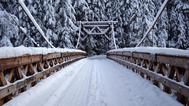
Longmire Community Building Viewpoint – Walk or drive along the road through Longmire, over the Nisqually Suspension Bridge, and to the Longmire Community Building. One of the best views of Mount Rainier from Longmire is from outside this building, which has a small parking lot and some picnic tables. The historic building is closed to visitors, but take a moment to visit the Valor Memorial, located next to the Community Building. NOTE: The Nisqually Suspension Bridge, which must be crossed to reach the community building, has a weight limit of 3 tons (6,000 pounds or 2721 kilograms). Vehicles over this weight limit CANNOT cross the bridge, including recreational vehicles (campers/trailers/motorhomes), maintenance trucks, box trucks, and medium trucks/SUVs pulling campers or trailers. Large trucks/SUVS can exceed the weight limit even without trailers. If your vehicle cannot cross the bridge, park in the main Longmire parking area near the National Park Inn and cross the bridge on foot.
Kautz Creek - Three miles east of the Nisqually Entrance, Kautz Creek offers the first viewpoint of Mount Rainier along the road. Please follow the short interpretive trail to the viewpoint instead of standing on the road. Restrooms and picnic tables are also available.
Family fun along the Trail of the Shadows in Longmire.
NPS Photo
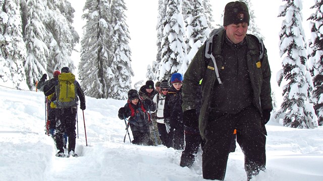
Family-friendly Winter Walks
Trail of the Shadows is an easy 0.7 mile-loop trail located across the road from the National Park Inn in Longmire. Interpretive signs along the trail explore the natural and cultural history of the area. During the winter, this trail often has a firm boot pack suitable for hiking or it can be snowshoed.
The Longmire Historic District Walking Tour explores the rustic architecture of Longmire. While interpretive signs are removed during the winter, you can still pick up a map at the Longmire Museum or follow the 1.25-mile, round-trip, self-guided tour using the NPS App.
Kautz Creek Nature Trail is a short interpretive trail out to a viewpoint that starts from Kautz Creek. The trail explores how debris flows have shaped the landscape of the park.
Snowshoe tracks along Westside Road, January 2013.
NPS/A. Spillane Photo
Moderate Hiking & Snowshoeing Routes
Wonderland Trail from Longmireto Cougar Rock Campground. Starting from Longmire, a section of the Wonderland Trail meanders parallel to the Nisqually River with a gentle incline to reach Cougar Rock Campground after 1.4 miles one-way. The Wonderland Trail continues over the Nisqually River at the Carter Falls crossing near Cougar Rock Campground, but the log footbridge is frequently washed out in winter. Return on the trail to Longmire; do not snowshoe or hike on the Paradise Road when it is closed to vehicles due to hazards from snowplows working on the road. Stop in at the Longmire Museum for maps and current conditions.
Rampart Ridge Trail in Longmire is a 4.6 mile-loop with 1,339 feet of elevation gain. The trail begins at the west end of the Trail of the Shadows, approximately 0.2 miles from the trailhead if heading clockwise. The loop can be hiked in either direction but going clockwise provides better views of Mount Rainier. The other end of the trail connects to the Wonderland Trail to return to Longmire. This trail is popular with snowshoers but is unmarked and requires winter navigation skills. Stop in at the Longmire Museum for maps and current conditions.
Twin Firs Trail is a 0.4 mile-loop trail through old-growth forest located two miles west of Longmire along the road between the Nisqually Entrance and Longmire. While short, a section of the trail is steep and in winter this trail is unmarked and requires winter navigation skills.
Westside Road is one mile from the Nisqually Entrance in the southwest corner of the park. The road closes for the winter at the junction of the Nisqually Road, but is open for hiking, snowshoeing, and cross-country skiing. Pets are not allowed. Park along the sides of Westside Road and do not block the gate. The closest restroom facility is at Kautz Creek. The road climbs approximately 670 feet through the forest over three miles to reach the summer closure gate at Dry Creek. NOTE: Traveling beyond Dry Creek requires experience with avalanche terrain and winter navigation. Just past Dry Creek is an area with a high risk of avalanches and rockfall, then the road continues along Tahoma Creek before climbing to Round Pass (an additional 3.8 miles from Dry Creek). From Dry Creek to Klapatche Pass at the road’s terminus, the road is 9.25 miles long with an elevation change of approximately 2,100 feet.
Experienced Winter Recreation
Eagle Peak Trail in the Longmire Area is 7.2 miles round-trip with 2,955 feet of elevation gain. For the first two miles the trail ascends steeply through dense forest to a small stream, then continues another mile to a meadow. Beyond the meadow the trail is much steeper and rocky as it climbs the final 0.5 mile to the saddle at 5,700 feet where the trail ends. During the winter, the upper, exposed sections of the trail can be hazardous avalanche terrain with snow cornices and steep dropoffs. Experience with avalanche terrain and winter navigation is required. Stop at the Longmire Museum for maps and current conditions. NOTE: The Nisqually Suspension Bridge, which must be crossed to reach the Eagle Peak trailhead, has a weight limit of 3 tons (6,000 pounds or 2721 kilograms). Vehicles over this weight limit CANNOT cross the bridge, including recreational vehicles (campers/trailers/motorhomes), maintenance trucks, box trucks, and medium trucks/SUVs pulling campers or trailers. Large trucks/SUVS can exceed the weight limit even without trailers. If your vehicle cannot cross the bridge, park in the main Longmire parking area near the National Park Inn and cross the bridge on foot.
Wonderland Trail from Longmireto Reflection Lakes is a strenuous 11 miles round-trip hike or snowshoe trip with approximately 2,400 feet of elevation gain. Starting from Longmire, follow the Wonderland Trail to Cougar Rock Campground, where the trail crosses the Nisqually River. The log footbridge is frequently washed out in winter so always check for current conditions before heading out on this hike. If the bridge is in, continue as the trail climbs along the Paradise River past Carter Falls and Narada Falls to Reflection Lakes. Experience with avalanche terrain and winter navigation is required. Return on the trail to Longmire; do not snowshoe or hike on the Paradise Road when it is closed to vehicles due to hazards from snowplows working on the road. Stop at the Longmire Museum for maps and current conditions.
East Side Winter Recreation
The US Forest Service District Office in Enumclaw provides information and maps for White River, Carbon River, and Mowich Lake areas. For more information, call the USFS District Office in Enumclaw at (360) 825-6585.
State Route 410 (SR 410) is closed near its junction with Crystal Mountain Ski Area Road, at the north park boundary near the SR 410 North Entrance Arch. Visitors must park in the Silver Springs Campground Sno-Park located off SR 410 on the road to Crystal Mountain. All vehicles must have the State SNO-park pass or be subject to a fine. No vehicles are allowed to park at the park entrance or block the entrance gate. Self-register for wilderness camping permits at the entrance arch. Hike, snowshoe, ski, or snowmobile on SR 410 to the White River Road and to White River.
State Route 123 (SR 123) in the southeast corner of the park closes for the winter at the SR 123 South Entrance Arch. The road can be hiked or snowshoed to access Ohanapecosh and the Silver Falls Trail. The Grove of the Patriarchs trailhead vault toilet remains open year-round, but the trail to the Grove is closed due the bridge washing out in 2021. Self-register for wilderness camping permits at the entrance arch. Park in roadside pullouts before the gate and do not block the entrance.
Winter Camping
Winter Camping requires a wilderness permit and is allowed once there is at least two feet of snow covering the ground (five feet in the Paradise area) and the winter camping season has started.
When snow cover is adequate, winter camping is permitted along the Nisqually to Paradise road corridor, depending on the Paradise Road schedule. It is allowed nightly throughout the remainder of park when there is sufficient snow cover. Visit the Winter Camping page or contact the Longmire Museum for permits and information.
Winter recreation access on the eastside remains unchanged. SRs 410 and 123 are closed to vehicles at the northeast, east, and southeast park boundaries. The east side of the park is open for visitor use throughout the winter, including overnight winter camping with a valid permit. SR 410 from the north park boundary and White River Road are open to snowmobiles up to the White River Campground.
Mount Rainier and the White River Valley viewed from Crystal Mountain Ski Resort.
K. Snure Photo
Winter Recreation Opportunities Near Mount Rainier National Park
Sledding
The closest alternative sledding and snow play area to Mount Rainier National Park is the tubing hill at White Pass Ski Area on US-12.
92 Road – Operated by Mount Tahoma Trails Association, six miles east of Elbe, near the southwest Nisqually Entrance of Mount Rainier National Park.
1 Road – Operated by Mount Tahoma Trails Association, east of Elbe on SR 706, then on DNR 1 Road in Tahoma State Forest. Near the southwest Nisqually Entrance of Mount Rainier National Park.
Silver Springs Campground - Operated by Snoqualmie Ranger District-Enumclaw, off SR 410 on Crystal Mountain Boulevard, near the northeast entrance to Mount Rainier National Park. Used to access SR 410 within the park for snowshoeing, skiing, and snowmobiling.
Mount Tahoma Trails Association
Based in Ashford just outside the Nisqually Entrance at the southwest corner of the park, Mount Tahoma Trails Association manages a network of trails and backcountry huts. Trails are well-signed logging roads in summer, groomed ski trails in winter, usually mid-November through mid-April depending on snow. Snowshoeing and hiking allowed (stay off groomed snow). See Mount Tahoma Trails Association website for details, including permits and regulations.
Gifford Pinchot National Forest
This large national forest stretches south from Mount Rainier National Park to the Columbia River. The Cowlitz Valley Area, managed by the Cowlitz Valley Ranger Station in Randle, WA, includes several wilderness areas near Mount Rainier. Check wilderness area webpages for information about seasonal trail access:
Tatoosh Wilderness shares the southern boundary of Mount Rainier National Park and is located just north of Packwood and northwest of US-12.
Goat Rocks Wilderness is southeast of Packwood on the crest of the Cascade Range south of US-12.
William O Douglas Wilderness is located in the southern Washington Cascade Mountain crest between White Pass (US-12) and Chinook Pass (SR 410) and east of Mount Rainier National Park.
Mount Baker-Snoqualmie National Forest
This national forest on the western slopes of the Cascade Range spans the distance from Mount Rainier National Park north to Vancouver, British Columbia. A few areas border the north side of the park:
Mather Memorial Parkway (SR 410) travels through the east side of Mount Rainier National Park (closed to vehicles during the winter), but also refers to the national forest area north of the park.
White Pass Ski Resort is east of Mount Rainier National Park at White Pass along US-12.
Gateway Communities
Restaurants, shopping, lodging and other amenities are available in gateway communities around Mount Rainier National Park. Near the southwest Nisqually Entrance: