Activity 2: Geologic Wonders

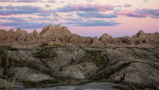
Badlands National Park landscape view.
A landscape view of the Badlands National Park.

NPS Photo / Mackenzie Reed

The National Park Service is home to some of the world's finest examples of geologic wonders and natural phenomena! Whether it's glaciers to barrier islands, from volcanoes, the Parks have it all including arches, canyons, caves, mountains and sand dunes.

Soak in the beauty our National Parks have to offer in the below images, then complete your activity by exploring some of these wonders online. As budding Geoscientists, let this list inspire your next adventure as you explore the great outdoors!
 

Build Your Bucket List Activity

Directions: For this fun activity you will Build Your Bucket List to see geologic wonders in National Parks!
  1. Using the links below, freely explore the various Must See Geologic Wonders sites. Make sure to check out pictures, videos, and locations of each of the Park sites you visit.
  2. As you visit each page ask yourself these questions: Which ones did you find yourself exploring more and more? Which of these geologic wonders would you like to visit one day?
  3. Fill the Geologic Wonders Activity section in your Junior Geoscientist Activity Log and start Building Your Bucket List!
  4. This activity will help you create a running list of National Parks you want to visit, what natural landscapes you want to see, and more!
  5. Don't stop here! Continue to build your bucket list and #FindYourPark across the National Park Service.
 
 
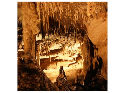
View inside of Mammoth Cave travertine in Kentucky.
Mammoth Cave National Park

NPS Photo

Mammoth Cave National Park

Kentucky

Mammoth is the longest recorded cave system in the world with over 400 mapped miles. Mammoth preserves part of an archetypal karst landscape in South-Central Kentucky with sinkholes, vertical shafts, windows, and springs amongst other features.

Geodiversity Atlas | Park Home
 

Hawai'i Volcanoes National Park

Hawai'i

Hawaii Volcanoes National Park contains the world's most massive mountain, Mauna Loa at 13,677 feet. The park also contains Kilauea, the world's most active volcano and produces enough volcanic material every day to cover a football field to the height of the Washington Monument and has been erupting continuously since 1983!
Geodiversity Atlas | Park Home

 
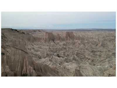
View of Palmer Creek in the Badlands.
Palmer Creek has some of the best preserved paleontological resources in the Park Service.

NPS Photo

Badlands National Park

South Dakota
Badlands contains some of the worlds most bizarre and "alien looking" landscapes; classic examples of badland topography. The poorly consolidated bedrock consisting of loose sediment and volcanic ash is quickly eroded by infrequent rainstorms. Resulting mud mounds, spires, and ridges resemble miniature mountain ranges.
Geodiversity Atlas | Park Home

 
Sandhill cranes fly over Blanca with a moonrise in the background.
Sandhill cranes flying over Blanca Peak near the Great Sand Dunes.

NPS Photo / Patrick Myers

Great Sand Dunes National Park and Preserve

Colorado
View the tallest sand dunes in North America and one of the most fragile and complex dune systems in the world. Sand and sediments deposited in the San Luis Valley were picked up by the fierce winds blowing towards the Northeast, then brought to the base at the Sangre de Cristo Mountains. These mountains stopped sand passage, creating the enormous dunes in the high mountainous setting.
Geodiversity Atlas | Park Home

 
Aerial view of Aniakchak Caldera.

NPS Photo

Aniakchak National Monument

Alaska
Aniakchak is located on the Alaska Peninsula, part of the Aleutian volcanic arc. The Aniakchak caldera is one of the youngest calderas in North America, erupting last in 1931 and is one of the finest examples of a dry caldera in the world. The Aleutian arc itself is one of the simplest and most visible subduction zones on Earth.
Geodiversity Atlas | Park Home

 
A view of the postpile from across the San Joaquin River.

NPS Photo

Devils Postpile National Monument

California

View one of the world's finest examples of columnar basalt with continuous columns over 60 feet high! Lava flows filled the Middle Fork of the San Joaquin River to over 400 feet deep and helped form the almost perfectly hexagonal columns. Around 10,000 years ago, glaciers truncated and carved into the lava flow, exposing the interior. The Devil's Postpile is a breathtaking site to see!

Geodiversity Atlas | Park Home

 
A view of the Phantom Ship, with Mount Scott in the distance. Taken near the summit of Garfield Peak.

NPS Photo

Crater Lake National Park

Oregon

Just under 2,000 feet, Crater Lake is the deepest lake in the United States and the second deepest in the Western Hemisphere! Mount Mazama once rising over 12,000 feet in the Cascade Range, erupted around 8,000 years ago. The cataclysmic emptying of the magma chamber caused the mountain to collapse, forming a deep caldera that has subsequently filled with rain and snow melt creating Crater Lake.
Geodiversity Atlas | Park Home

 
Rainbow Bridge With Navajo Mountain.

NPS Photo

Rainbow Bridge National Monument

Utah

The world's largest natural bridge is over 290 feet tall and 275 feet wide! Water flows through the Bridge Canyon drainage in a tight curve around a thin fin of soft Navajo Sandstone jutting into the canyon. Eventually this fin was breached and Bridge Creek changed course to flow through Rainbow Bridge. When full, Lake Powell obscures some of the height of Rainbow Bridge.
Geodiversity Atlas | Park Home

 
Freeze/thaw action fractures rock revealing the fossils.

NPS Photo

Fossil Butte National Monument

Wyoming

Find some of the most nearly perfectly preserved fossils of ancient plant and animal life in the world! Fossil Butte contains one of the world's best collection of fossilized freshwater fish, hundreds of insect species, uncounted plant species, and various other organisms such as bats, birds, turtles, and crocodiles. Fossil Butte originated as Fossil Lake, where the calcium carbonate helped preserve the organisms which fell to the bottom of the lake.
Geodiversity Atlas | Park Home

 
View at White Sands National Park.
Landscape view at White Sands National Park.

NPS Photo

White Sands National Monument

New Mexico

Contains one of the few examples of yardangs in the United States. Yardangs are streamlined, wind-eroded ridges found in arid regions. The White Sands' yardangs are well developed and impressive in size. The elongate yardangs form in the lightly cemented gypsum sand and are eroded by the prevailing southwest to northeast winds.

Geodiversity Atlas | Park Home


Important Links


Last updated: December 30, 2022

Park footer

Contact Info

Mailing Address:

142 W. Potomac St.
Williamsport, MD 21795

Phone:

301-739-4200

Contact Us