
NPS photo
The Central Lowlands province is the largest of the physiographic provinces in the continuous US, spanning 941,500 square km (585,000 mi). This largely level region rises less than 300 m (1,000 ft) above sea level in the east to less than 610 m (2000 ft) to the west. Many of the features of the Central Lowlands extend into Canada. The Central Lowlands were subject to repeated Pleistocene glaciations and can be divided into regions based on glacial features, including the Great Lakes, Small Lakes, Driftless Area, Till Plains, Dissected Till Plains, and Osage Plains. Underlying glacial deposits are largely horizontal Paleozoic sandstones, shales, limestones, conglomerates, and coals.
The Great Lakes, in the northern Central Lowlands are the result of repeated glacial scouring. The shape and orientation of the lakes is a product of preglacial streams and weak rocks bordering resistant rocks that influenced the path of advancing ice. The Great Lakes reach depths of more than 100 m (330 ft) below sea level. The deepest is Lake Superior at 213 m (700 ft) below sea level. Niagara Falls was formed in the late history of the Great Lakes when Lake Ontario, then at the same elevation as Lake Erie, began to drain through the Mohawk outlet. When the level of Lake Ontario fell below the Niagara escarpment, the falls appeared. The falls are supported by dolomite underlain by sandstone. As this sandstone erodes, large pieces of the dolomite break off leading to an upstream retreat of the falls. At this time, the Canadian Horseshoe Falls are about 53 m (175 ft) high and the American Falls are 56 m (185 ft) high. More water passes over Niagara Falls than any other falls in North America.
Glacial Lake Agassiz once covered more than 160,900 square km (100,000 mi) and has been called the “greatest of all glacial lakes.” It covered eastern North Dakota and northwestern Minnesota, and extended into Canada. When Lake Agassiz existed, Hudson Bay was covered by glacial ice. As the ice retreated, the lake water drained into the bay. The principal remains of Glacial Lake Agassiz are preserved in Canadian Lake Winnipeg.
The Driftless Area is a small region in southwestern Wisconsin that was protected from glaciers by the resistant ridges of the Superior Uplands. The area is unique in that it preserves rock features including arches, natural bridges, and butte-like landforms. The Driftless area is classified as a desiccated plateau, and the Wisconsin Dells, where the Wisconsin River has carved through the rock, is a scenic location.
Many mineral resources are found throughout the Central Lowlands. Petroleum is extracted from oil fields in Texas, Kansas, and Oklahoma; as well as in Indiana, Michigan and Illinois. Salt beds and natural brines in the Michigan basin are a source of salt, and sandstone and limestone are quarried in Ohio and Indiana. The Driftless Area in Wisconsin has a history of lead and zinc production from the minerals galena and sphalerite. The St Peter Sandstone underlies much of the midcontinent and is a source of sand used to make high-grade glass.
Educational Resources
This unit will introduce students to the importance of water ecology. Chickasaw National Recreation Area was originally established for the protection of the mineral and freshwater springs within its boundaries. In this unit, you will explore the many springs throughout the park.
Introduction to Unit
Lesson 1 - The Water Cycle (Grade K-12)
Lesson 2 - Look What's Spring Up (Grade K-12)
Lesson 3 - Mineral Content (Grade 9-12)
Lesson 4 - Water & Springs (Grade 6-8)
Lesson 5 - Water at Chickasaw (Grade 3-5)
Mineral Content of Springs

NPS photo
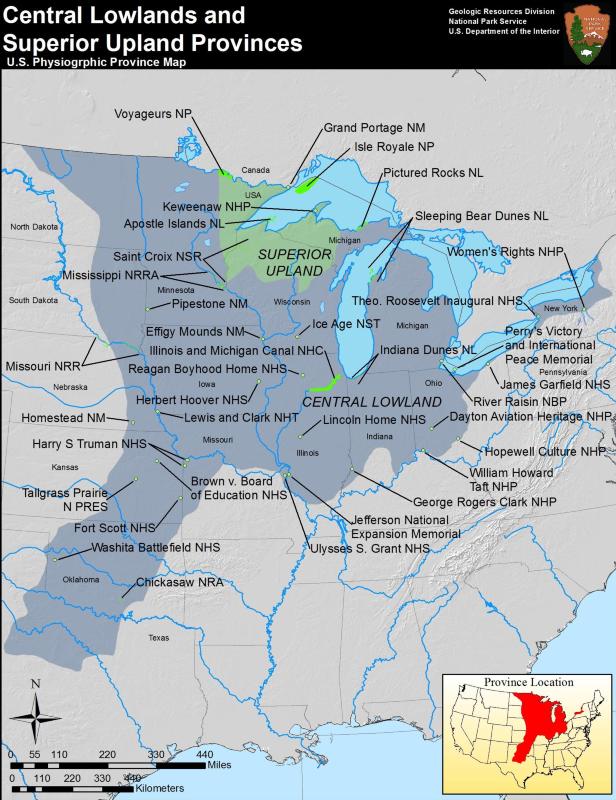
Central Lowland Parks
- Brown vs. Board of Education National Historic Site, Kansas—[Geodiversity Atlas] [Park Home]
- Chickasaw National Recreation Area, Oklahoma—[Geodiversity Atlas] [Park Home]
- Dayton Aviation Heritage National Historical Park, Ohio—[Geodiversity Atlas] [Park Home]
- Effigy Mounds National Monument, Iowa—[Geodiversity Atlas] [Park Home]
- Fort Scott National Historic Site, Kansas—[Geodiversity Atlas] [Park Home]
- George Rogers Clark National Historical Park, Indiana—[Geodiversity Atlas] [Park Home]
- Herbert Hoover National Historic Site, Iowa—[Geodiversity Atlas] [Park Home]
- Hopewell Culture National Historical Park, Ohio—[Geodiversity Atlas] [Park Home]
- Homestead National Monument of America, Nebraska—[Geodiversity Atlas] [Park Home]
- Harry S. Truman National Historic Site, Missouri—[Geodiversity Atlas] [Park Home]
- Indiana Dunes National Lakeshore, Indiana—[Geodiversity Atlas] [Park Home]
- James A. Garfield National Historic Site, Ohio—[Geodiversity Atlas] [Park Home]
- Jefferson National Expansion Memorial, Missouri—[Geodiversity Atlas] [Park Home]
- Lincoln Home National Historic Site, Illinois—[Geodiversity Atlas] [Park Home]
- Mississippi National River & Recreation Area, Minnesota—[Geodiversity Atlas] [Park Home]
- Missouri National Recreational River, South Dakota—[Geodiversity Atlas] [Park Home]
- Pictured Rocks National Lakeshore, Michigan—[Geodiversity Atlas] [Park Home]
- Pipestone National Monument, Minnesota—[Geodiversity Atlas] [Park Home]
- Saint Croix National Scenic River, Wisconsin, Minnesota—[Geodiversity Atlas] [Park Home]
- Sleeping Bear Dunes National Lakeshore, Michigan—[Geodiversity Atlas] [Park Home]
- Tallgrass Prairie National Preserve, Kansas—[Geodiversity Atlas] [Park Home]
- Theodore Roosevelt Inaugural National Historic Site, New York—[Geodiversity Atlas] [Park Home]
- Ulysses S. Grant National Historic Site, Missouri—[Geodiversity Atlas] [Park Home]
- Voyageurs National Park, Minnesota—[Geodiversity Atlas] [Park Home]
- Washita Battlefield National Historic Site, Oklahoma—[Geodiversity Atlas] [Park Home]
- William Howard Taft National Historic Site, Ohio—[Geodiversity Atlas] [Park Home]
- Women's Rights National Historical Park, New York—[Geodiversity Atlas] [Park Home]
Part of a series of articles titled Physiographic Provinces.
Previous: Cascade-Sierra Mountains Province
Next: Coastal Plain Province
Last updated: April 30, 2018