An official website of the United States government
Here's how you know
Official websites use .gov A
.gov website belongs to an official government
organization in the United States.
Secure .gov websites use HTTPS A
lock (
) or https:// means you've safely connected to
the .gov website. Share sensitive information only on official,
secure websites.
This Backcountry Conditions page includes general backcountry information, links to important backcountry-related sites, the Backcountry Conditions Map, and the Area Condition Details section. The map offers a quick snapshot of current trail, trailhead, and campsite status. It includes area closures, restrictions, and known hazards. Below the map is Area Condition Details, which provides detailed information regarding those locations and conditions, as well as more information for stock users. Please make sure to review the BackcountryConditions Map and Area Condition Details before heading into the backcountry.
Backcountry Conditions provides specific details about a given trail on a given date. However, Yellowstone's backcountry is vast and status of a lesser used trail might not be updated for several weeks or even months. For this reason, Backcountry Conditions only offers a snapshot of trail conditions and should be used in conjunction with other tools such as weather reports, prior backpacking experience in Yellowstone, and assessment of your own backpacking skill level.
*This map doesn't reflect current campsite availability. Backcountry permits are required to camp in all backcountry campsites.
Click on segments of trails, colored polygons, or icons for more information.
General Information
Check out the snowpack map to see where and how much snow you could encounter. Reference the map located on the right side of the linked page (this map depicts snow depth).
Most streams are dropping and are starting to become crossable. Streams which are crossable in the morning may rise to unsafe levels by afternoon. Don’t get caught on the wrong side of a stream. If you must cross, scout out the safest location. The best crossing may not be in the exact location where the trail meets the stream. Above all use caution and be safe around all streams.
Yellowstone does not have many bridges, please evaluate planned travel routes for any potentially hazardous stream crossings. River crossing sandals and trekking poles recommended.
Due to the flood in 2022 many of the streams within the Northern section of the park have changed their course. Scout up and down stream for the best place to cross, which is not neccesarily where the trail meets the stream.
Beginning July 29, Yellowstone National Park’s rivers and streams will be closed to fishing daily from 2 p.m. to sunrise due to high water temperatures and low stream flows. These restrictions are in addition to the existing full fishing closures on the Madison, Firehole and Gibbon (downstream of Norris Campground) rivers that have been in effect since July 15.
What will be closed?
Fishing on all park rivers and streams will be prohibited daily from 2 p.m. to sunrise the following day.
Fishing remains temporarily prohibited on the Madison, Firehole and Gibbon (downstream of Norris Campground) rivers.
These closures will remain in effect until conditions improve to protect the park’s native and wild trout fisheries.
What will be open?
Anglers can fish on most park rivers and streams daily from sunrise to 2 p.m.
Yellowstone Lake and other lakes will remain open to fishing from sunrise to sunset as specified in the 2026 Fishing Regulations booklet.
Yellowstone National Park 2026 boating season is open. Make sure to review the Boating page for further information. (5/23/26)
A 30-day dry time is required for all sailboats and certain motorized boats(inboard, inboard/outboard, or inboard jet drives). Boats without a valid AIS inspection receipt and intact seal demonstrating a 30-day day dry time will be denied launch. Make sure to review the Boating page for further information. (5/23/26)
Yellowstone Lake, Shoshone Lake, and Lewis Lake are ice free. (5/23/26)
Docks and buoys are in place. It is the boaters reponsibility to know where the hazards, mileage zones, and non-motorized boat zones are, and to abide by regulations. (6/4/26)
Use caution and be alert for floating debris and unmarked hazards. (5/23/26)
Lake Spawn and Clear Creek Bear Management Area restrictions are in effect along east shore of Yellowstone Lake and adjacent land. (5/23/26)
There are several closures in effect to protect nesting birds. Bird closure areas are in effect near Frank Island, Stevenson Island, Molly Islands, Peale Island, Campsites 7N2/7N4 and 7L7. No travel on or near the closures. See map above for location of closures. (5/23/26)
The following trails are OPEN to stock day use: Blacktail Deer Creek Trail, Yellowstone River Trail, Hellroaring Creek Trail, Slough Creek Trail, Pebble Creek, Glen Creek Trailhead, Fawn Pass,Indian Creek ( up to just below the pass), Mount Holmes Trailhead, and Bacon Rind Trail.(6/24/26)
All other trails are currently CLOSED to stock use. Check back in June for trails that may be open for day use prior to July 1.
Overnight stock use is not permitted until July 1.
All stock use requires a permit. Call the Central Backcountry Office or go online to request a day ride permit. Overnight horseback use is closed for the season.
Trails that are not suitable and closed year round to Stock Use: Osprey Falls, Bunsen Peak, Lava Creek, Wraith Falls, Sheepeater Trail, Tower Falls, Chittenden Road, Lost Lake, Artist Point/Point Sublime, Storm Point, West Thumb Overlook, Monument Geyser Basin, Harlequin Lake, Beaver Ponds, Upper Terraces, Trout Lake, Seven Mile Hole, North/South Rim Canyon, Avalanche Peak, Clear Lake, Elephant Back, Riverside, Shoshone Geyser Basin, Artist Paint Pots, Fairy Falls, and any geyser basin or thermal area.
Yellowstone's current fire danger is : High. There are no current fire restrictions, however please note not all campsites allow for fires. Check your backcountry permit to see if your permited campsite allows for fires, or view our backcountry trails and campsite map. In addition, please note that fires are only allowed in designated firepits. If the firepit is under snow visitors will need to dig out the firepit and downed wood.(4/9/26)
Mammoth Backcountry Office located in Albright Visitor Center
OPEN
Tower Ranger Station
OPEN
West Yellowstone Visitor Information Center
OPEN
Snake River Ranger Station (South Entrance)
OPEN
Grant Backcountry Office
OPEN
Bridge Bay Ranger Station
OPEN
Bechler Ranger Station
Open
*Offices are open 8-5 (backcountry permits will not be issued after 4:30 pm). Offices are closed for lunch.
During non-peak season there are no locations open for in-person permits. Starting in the middle of May, offices will begin to be staffed and permits will no longer be available over the phone. (4/9/26)
If you have a trip reserved during non-peak season please watch the Backcountry Safety Video and then give our office a call at 307-344-2160 within 5 days of your start date. At the time of your call we will go over the permit and issue you your permit to be printed from home or downloaded to your phone. The Central Backcountry Office is staffed M-F, 8:00 to 4:30pm. Please note is not staffed on weekends and holidays. Please plan accordingly.(4/9/26)
For last minute trips (within 3 days of your start trip) contact the Central Backcountry Office at 307-344-2160. The Central Backcountry Office is staffed 7 days/week, 8:00 to 4:30pm. Please note the office IS Not staffed on weekends and holidays. Please plan accordingly. (4/9/26)
Area Condition Details
Trails are listed by region as shown on the map below. Scroll down or select a region name to view backcountry conditions for the area: NorthwestNortheastCentralSouthwestSoutheast
A minimum group size of four people is recommended for hiking and camping withing the Gallatin Bear Management Area.
FISHING: Beginning July 29, Yellowstone National Park’s rivers and streams will be closed to fishing daily from 2 p.m. to sunrise due to high water temperatures and low stream flows. These restrictions are in addition to the existing full fishing closures on the Madison, Firehole and Gibbon (downstream of Norris Campground) rivers that have been in effect since July 15.
What will be closed?
Fishing on all park rivers and streams will be prohibited daily from 2 p.m. to sunrise the following day.
Fishing remains temporarily prohibited on the Madison, Firehole and Gibbon (downstream of Norris Campground) rivers.
These closures will remain in effect until conditions improve to protect the park’s native and wild trout fisheries.
What will be open?
Anglers can fish on most park rivers and streams daily from sunrise to 2 p.m.
Yellowstone Lake and other lakes will remain open to fishing from sunrise to sunset as specified in the 2026 Fishing Regulations booklet.
Trail from Black Butte to Sky Rim is free of snow. (6/8/26)
Sky Rim Trail has some areas that are exposed along a ridge. Use caution when hiking. (7/15/26)
Low water sources at site WF2.
Trail Clearing Status: Cleared Daly-Black Butte Trail. (5/7/26); Daly Creek Trail cleared to the pass. Black Butte cleared to Sky rim. (6/24/26)
Stock Use. Open to stock. (7/1/26)
All creek crossings are passable. (6/25/26)
Trails Clearing Status: Specimen Creek, High Lake, Crescent Lake, Sportsman's trail up to .5 to the end of tree line towards Sportsman's Lake Pass are cleared of downfall. (6/25/26)
Visitor report that Electric Peak is clear of snow. 6/22/26
Trail Clearing Status: Glen Creek side is cleared of downfall. Specimen Creek Trail cleared to about 1.5 miles past the Sportsman's Lake Trail. (7/1/26)
Stock Use: Open to stock. (7/1/26)
Bunsen Peak Trail is clear.(7/16/26)
The Osprey Falls Trail will be temporarily closed for critical trail repair work July 28–Aug. 4.
July 28-29 and Aug. 1-4: Daily closures (8 a.m.–4 p.m.)
July 30-July 31: Full‑day closures.
The Old Bunsen Peak Road will remain open and only the spur trail to Osprey Falls will be temporarily closed.
Osprey Falls Trail dry and in good condition. (5/9/26)
Stock Use: Bunsen Peak and Osprey Falls trails not suitable/CLOSED to stock.
Stock Use: Not suitable/CLOSED for stock.
Bighorn - Fawn Pass loop has some residual boggy spots. (5/26/26)
Bear Frequenting Area warning in effect for eastern section of Fawn Pass Trail. (7/5/26)
Stock Clearing Status: Bighorn - Fawn Pass loop cleared. Fawn Pass Trail from Glenn Creek to the pass is cleared. Fawn Pass Trail to Sportsman's Lake is cleared. Fawn Pass Trail to the Patrol Cabin cleared. (6/23/26)
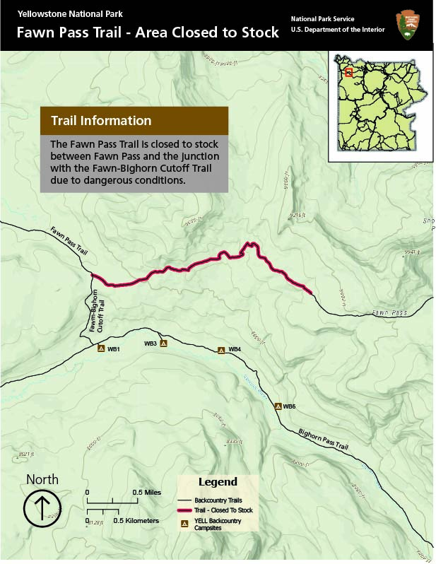
Stock Use: Open to stock. (7/1/26) Fawn Pass Trail is closed to stock from Fawn Pass to the junction with the Fawn Pass Trail-Bighorn Cutoff Trail due to dangerous conditions. See Map. (6/24/26)
Bighorn Pass Trailhead/Indian Creek is now open. (6/25/26)
Trail Clearing Status: Bighorn Pass Trail is cleared from the west to just before the pass. Bighorn Pass Trail is cleared from the east to the pass.
Stock Use: Open to stock. (7/1/26) Indian Creek (East side of Big Horn Pass Trail) is open to stock up till about 1/2 mile from the pass. (6/16/26) Bighorn Pass/Fawn Pass loop is open to stock. Fawn Pass is closed to stock just west of loop because of a hazardous boggy area. (6/16/26)
Trails are open. (7/15/26)
Trail Clearing Status: Cleared of downfall. (7/9/26)
Stock Use: Open to stock. (7/1/26)
Trail open except beaver activity about 7 miles in from the Gneiss Creek Trailhead has resulted in trail flooding and deep mud, making it impassable. (7/1/26)
Stock Use: Open to stock except the beaver-impacted area mentioned above. See map. (7/1/26)
Trail is snow free. (5/20/26)
Trail Clearing status: Not cleared. (4/9/26)
Stock Use: Trail is not suitable/CLOSED for stock.
Trail is open. (7/15/26)
Trail Clearing status: Not cleared. (4/9/26)
Stock Use: Trail is not suitable/CLOSED to stock.
Trail open. (5/20/26)
Trail Clearing Status: Not cleared. (4/14/26)
Stock Use: Trail is not suitable/CLOSED to stock.
Northeast
Due to the 2022 flood event, many of the rivers in the northern section of the park have changed course. As a result, the locations where trails intersect the rivers may not always be the safest places to cross. Take time to scout upstream and downstream to find the best crossing points.
FISHING: Beginning July 29, Yellowstone National Park’s rivers and streams will be closed to fishing daily from 2 p.m. to sunrise due to high water temperatures and low stream flows. These restrictions are in addition to the existing full fishing closures on the Madison, Firehole and Gibbon (downstream of Norris Campground) rivers that have been in effect since July 15.
What will be closed?
Fishing on all park rivers and streams will be prohibited daily from 2 p.m. to sunrise the following day.
Fishing remains temporarily prohibited on the Madison, Firehole and Gibbon (downstream of Norris Campground) rivers.
These closures will remain in effect until conditions improve to protect the park’s native and wild trout fisheries.
What will be open?
Anglers can fish on most park rivers and streams daily from sunrise to 2 p.m.
Yellowstone Lake and other lakes will remain open to fishing from sunrise to sunset as specified in the 2026 Fishing Regulations booklet.
Campsite 1A3 has a bear frequenting the area. (7/27/26)
Rescue Creek Trailhead along the washed out North Entrance Road is inaccessible due to the bridge having washed out in the 2022 floods. See conditions map above.
Rescue Creek Trail accessed from the Blacktail Trailhead is open. (4/9/26)
The Lava Creek Trail accessed from the Blacktail Trailhead is open. The trail can be hiked to the Gardner River, but you will need to return the same way. The bridge over the Gardner River is out. (4/9/26)
Trail Clearing Status: Rescue Creek Trail (from Blacktail Creek Trail) has been cleared. (5/12/26)
Stock Use: Rescue Creek Trail via Blacktail Creek Trail is open to stock. Lava Creek Trail is not suitable/CLOSED to stock. (6/25/26)
Wraith Falls Trail is clear of downfall and in good shape. (5/18/26)
Stock Use: Not suitable/CLOSED to stock. (5/9/26)
Blacktail Creek Trail is dry. (5/4/26)
In 2022 a section of the Yellowstone River trail was washed out 1/2 mile west of campsite 1Y1. Follow the flagged route around the washout. The trail at the washout and the reroute is CLOSED to stock use.
1R3 water sources are dried up, nearest water is at Little Cottonwood Creek 1/2 mile away.
Stock Use: Open to stock, except section described above. (7/1/26)
Hellroaring Creek may be too deep and swift to safely cross on foot or by stock. Visitors can scout for a possible place to cross or use the bridge approximately 1.2 miles north of 2H6 to cross. (7/15/26)
Reports that trail north of the park at Buffalo Plateau (Poacher's Trail Heading towards Bull Mountain), are unmaintained, with lots of trees down.(6/29/26)
Stock Use: Open to stock. See note above regarding Hellroaring Creek and Buffalo Plateau. (7/1/26)
Lost Lake Trail is open. (4/9/26)
Trail to Lost Lake Falls is CLOSED due to wash out.See map above. (4/9/26).
Trail Clearing Status: Cleared of downed trees. (5/7/26)
Stock Use: Not suitable/CLOSED to stock.
The Garnett Hill Trail is open to foot travel. Garnet Hill Trailhead is closed due to road construction. The Garnet Hill Trail is accessible from the Tower Junction parking area. Follow the signs and flagging.
Use caution when crossing the road and stay alert for horses and wagons. Please step off the trail when you see the wagons. (5/20/26)
Trail Clearing Status: Trail has been cleared. (5/11/26)
Stock Use: Not suitable/CLOSED to stock due to washout.
Trail open. (5/9/26)
Trail Clearing Status: Not Cleared. (4/9/26) Stock Use: Not suitable/CLOSED to stock.
Buffalo Fork Trail is now accessible via Slough Creek. Use caution crossing creek. (6/25/26)
Trail Clearing Status: Cleared. (5/7/26)
Stock Use: Open to stock. (6/25/26)
Slough Creek crossing near Elk Tongue Cabin is 2-3 feet deep and slow moving. (6/28/26)
Campsite 2S8 is CLOSED due to bear activity. (7/22/26)
Bear Frequenting Area warning in effect for campsite 2S3. (7/15/26)
Strong Bear Warning in effect at campsite 2S6. (7/22/26)
Pebble Creek is likely crossable. All sites are open in the area. (6/22/2026).
Warm Creek Trailhead will be temporarily closed on August 12 and 13th for helicopter operations. (7/20/26)
Starting May 28 there will be intermittent helicopter operations utilizing the Pebble Creek Stock Trailhead (the larger parking area to the west). During that time visitors should park at the smaller Pebble Creek Trailhead across the bridge to the east. (5/7/26)
Bliss Pass is passable. (6/24/26)
Trail Clearing Status: Pebble Creek and Bliss Pass trails cleared. (6/24/26)
Stock Use: Pebble Creek/Warm Creek open to stock. (6/24/26)
Trail is open. (5/12/26)
Stock Use: Not suitable/CLOSED to stock.
The Lamar River located on the east side of the Specimen River Trail is crossable. Use caution. (6/26/26)
Yellowstone River Picnic Area Trailhead is CLOSED. (7/6/26)
Report that the bridge abutment across Blacktail Creekis failing (bridge leads to campsite 1Y6 and 1Y8) visitors should cross the creek on foot further downstream. (7/31/26)
Food pole at campsite 2Y1 is down. Approved hard-sided bear container required. Contact Central Backcountry Office to reserve. (7/15/26)
Trail Clearing Status: Trail cleared to Amethyst Mountain. (6/25/26)
Stock Use: Open to stock. (6/26/26)
Campsite 3L7 is CLOSED due to a carcass in the area. No fishing within 1/4 mile either direction of campsite 3L7. Strong Bear Warning in effect for campsite 3L6. (7/29/26)
Campsite 3F2 is CLOSED due to bear activity. Strong Bear Warning in effect for campsites 3F1, 3U3, 3U2, 3U1. (7/30/26)
Strong Bear Warning in effect for the Lamar River Trail from junction with Miller Creek Trail to junction with Pelican Valley Trail, and Frost Lake Trail to campsite 3F2. Be bear aware and make sure food is stored properly at all times. (7/30/26)
Fords in Lamar Valley are crossable. Use caution. (6/26/26)
Trail Clearing: Lamar RiverTrail and Miller Creek cleared. (7/15/26)
Stock Use: Open to stock.Soda Butte Creek at Soda Butte Stock Trailhead is crossable for stock (2-3.5 feet moderately swift). Some boggy sections south of the trailhead. (6/26/26)
Trails are open. (7/15/26)
Soda Butte Creek crossing at the Thunderer Trailhead is 2-3 feet. (6/25/26)
Trail clearing status: Thunderer Trail and Cache Creek Trail have been cleared of downfall. (6/25/26)
Stock Use: Thunderer Trail and Cache Creek Trail open to stock. (6/25/26)
FISHING: Beginning July 29, Yellowstone National Park’s rivers and streams will be closed to fishing daily from 2 p.m. to sunrise due to high water temperatures and low stream flows. These restrictions are in addition to the existing full fishing closures on the Madison, Firehole and Gibbon (downstream of Norris Campground) rivers that have been in effect since July 15.
What will be closed?
Fishing on all park rivers and streams will be prohibited daily from 2 p.m. to sunrise the following day.
Fishing remains temporarily prohibited on the Madison, Firehole and Gibbon (downstream of Norris Campground) rivers.
These closures will remain in effect until conditions improve to protect the park’s native and wild trout fisheries.
What will be open?
Anglers can fish on most park rivers and streams daily from sunrise to 2 p.m.
Yellowstone Lake and other lakes will remain open to fishing from sunrise to sunset as specified in the 2026 Fishing Regulations booklet.
Chittenden Road and Dunraven Pass Trailheads are open. (6/8/26)
Stock Use: Open to stock. (7/1/26)
Seven Mile Hole Trail is open. (6/4/26)
Trail Clearing Status: Trail is cleared of downfall. (6/3/26)
Stock Use: Not suitable/CLOSED to stock.
Trail is open. (5/10/26)
Trail clearing status: Not cleared. (4/14/26)
Stock Use:Opento stock. (7/1/26)
Report of Grizzly bear around the Cascade Lake Area. Be Bear Aware and keep all food an scented items properly stored- directly with you, or hung up on a food pole 10 feet up in the air. (7/13/26)
Trail Clearing Status: Ice Lake,Cascade Lake, Observation Peak, and Grebe Lake trailscleared. (6/3/26)
Stock Use: Opento stock (7/16/26)
Open
Stock Use: Not suitable/CLOSED to stock.
Trail Clearing Status: Clear Lake/Point Sublime trails, and Upper Falls to Ribbon Lake cleared. (5/6/26)
Stock Use: Ribbon Lake/Wrangler Lake trails opento stock, with exception of Clear Lake, which is not suitable/CLOSED to stock. (7/1/26)
Wapiti Lake Trail is clear to Wrangler Lake (4W1). Two Small stream crossings (able to jump over). One crossing is 15 " deep. Lots of Mosquitos. (6/22/26)
Wapiti Lake Trail is clear to Moss Creek. (6/16/26)
Trail Clearing Status: Wapiti Lake Trail to Ribbon Lake,Broad Creek, and Pelican Springs has been cleared of downfall. (7/21/26)
Stock Use:Open to stock, with above mentioned considerations. (7/4/26)
Howard Eaton Trail (north end) cleared. (5/13/26)
Howard Eaton Trail (south end) cleared and Fishing Bridge to LeHardy Rapids cleared. (5/14/26)
Sour Creek (along the Sour Creek Trail and Wrangler Lake Trail) is 2-3.5 feet deep. (5/13/26)
Trail Cleared status: Howard Eaton Trail cleared. (5/13/26)
Stock Use:Open to stock. (7/1/26)
Crater Hills in Hayden Valley CLOSED for wildlife protection (see map above). (5/27/26)
FISHING: Beginning July 29, Yellowstone National Park’s rivers and streams will be closed to fishing daily from 2 p.m. to sunrise due to high water temperatures and low stream flows. These restrictions are in addition to the existing full fishing closures on the Madison, Firehole and Gibbon (downstream of Norris Campground) rivers that have been in effect since July 15.
What will be closed?
Fishing on all park rivers and streams will be prohibited daily from 2 p.m. to sunrise the following day.
Fishing remains temporarily prohibited on the Madison, Firehole and Gibbon (downstream of Norris Campground) rivers.
These closures will remain in effect until conditions improve to protect the park’s native and wild trout fisheries.
What will be open?
Anglers can fish on most park rivers and streams daily from sunrise to 2 p.m.
Yellowstone Lake and other lakes will remain open to fishing from sunrise to sunset as specified in the 2026 Fishing Regulations booklet.
Biscuit Basin Trailhead is CLOSEDdue to thermal activity. Can use Daisy Trail. (6/29/2026)
Stock Use: Fairy Falls Trail CLOSED to stock - unsuitable.
Summit Lake Trail is open. (6/29/2026)
Trail in good shape. No water available until Summit Lake. (7/9/26)
Trail Clearing Status: Cleared. (7/9/26)
Stock Use:Open to stock. (7/1/26)
Mallard Lake Trail is open. (7/1/26)
Stock Use: Open to stock. (7/1/26)
Trails are open. (7/15/26)
Section of trail climbing from Shoshone Lake Trail junction to campsite 9D4 is rutted. (7/6/25)
Caution: ground bees have nested between Lone Star Geyser and Howard Eaton Trail intersection when in season. (5/9/26)
Trail Clearing Status: Cleared up to campsite OA3. (5/31/26)
Stock Use: Opento stock. (7/1/26)
On Delacy Creek trail, when you get to the lake there is an outlet that you cross (about a foot and half deep) in order to continue on the North Shoshone Shore trail. Bring river crossing shoes. (6/9/26)
Trails around Shoshone Lake are clear and mostly dry. (6/15/2026)
Section of trail between Shoshone Geyser Basin and campsite 8T1 goes through a very wet marshy area that currently has a mile-long section of trail with 6+ inches of standing water. Several creeks in this area are 3 or more feet deep even if only 5-6' wide. (6/16/26)
Moose Creek and Shoshone Outlet are 1-2' deep and very passable, although always use caution. (6/16/26)
Winds from the southwest often build during the morning and afternoon on Lewis and Shoshone lakes. They can be formidable. Plan ahead (early starts) and use caution on the lakes. (5/23/26)
Please note there is an blue unmanned weather catamaran anchored on Lewis Lake. Visitors have mistaken it as a boater in distress, but it is a floating research station gathering weather and water temps. (5/9/26)
Trail Clearing Status: Trails around lake,Lewis River Trail, Delacy Creek and Dogshead trail are cleared of downfall. (6/16/26)
Stock Use: Opento stock, with exception of the Shoshone Geyser Basin which is not suitable for stock and CLOSED year round.
The Bechler Canyon trail overall is in good condition. (7/28/26)
River crossings are about 24" deep. Mosquitos are bad at night. (7/6/26)
Food pole at 9D2 has been replaced. (7/16/21)
Trail Clearing Status: Cleared from Bechler ranger station to campsite 9D4 (5/26/26) Bechler River Trail cleared. (7/5/26)
Stock Use: Open to stock. 7/28/26
Bechler Meadows area dry except for the perpetually muddy patches. (7/28/2026)
Trail Clearing status: Boundary Creek Trail and Bechler Meadows Cutoff Trail cleared. (7/28/26)
Stock Use: Open to stock. (7/29/26)
Boundary Creek to Dunanda: Trails cleared. Bartlett Slough Bridge is usable. (7/28/26)
Trail to Buffalo Lake from western park boundary in good shape but multiple places where trees with blazes have fallen. Fords are about 12" deep. (7/4/26)
Bartlett Creek Bridge is usable. (7/28/26)
Trail Status: Bechler Creek Trail to Dunanda Falls cleared. (6/19/26)
Stock Use: Open to stock. Section of Boundary Creek Trail between 9A4 and 9A5 is CLOSED to stock due to hazardous conditions. (7/8/26)
Trail is open. (7/15/26)
Trail Clearing Status: Not cleared. (4/16/26)
Stock Use: Bechler area trails are now open to stock except for Bechler Meadows (CLOSED area: Boundary Creek Trail from Bartlett Slough to campsite 9A0, Bechler Meadows Trail from campsites 9B1 to 9B2, and Bechler Meadows Cutoff Trail. (7/8/26)
Grassy Lake Road is open. (6/3/26)
Fish Lake - Mountain Ash Cutoff Trail is CLOSED. (7/10/26)
Trails in the area are in good shape and mostly dry (6/25)
Falls River crossings in area reported to be approximately 20 Inches deep. (6/25/26)
Mosquito's are not bad during the day, but bad and night. (6/25/26)
There is a large beaver dam-impacted area on the Mountain Ash Trail west of campsite 9U1. Use caution when hiking past the area. (6/20/26)
Trail Clearing Status: Union Falls section of the Mountain Ash Creek Trail cleared.Grassy Lake to Union Falls (6/25/26)
Stock Use: Opento stock. (7/1/26)
Pitchstone Plateau trail is in good condition. Buggy (7/6/26)
Trail/campsites have limited water. (7/15/26)
Trail Clearing Status: Cleared. (7/6/26)
Stock Use: Opento stock. (7/1/26)
Grassy Lake Road is open.(6/3/26)
No travel south of 9U1 due to carcass. Fish Lake Trailhead is CLOSED. (7/13/2026)
Trail Clearing Status: Buela Lake Trail cleared. (6/30/26)
Stock Use: Open to stock, except the above mentioned closures. (7/1/26)
Southeast
FISHING: Beginning July 29, Yellowstone National Park’s rivers and streams will be closed to fishing daily from 2 p.m. to sunrise due to high water temperatures and low stream flows. These restrictions are in addition to the existing full fishing closures on the Madison, Firehole and Gibbon (downstream of Norris Campground) rivers that have been in effect since July 15.
What will be closed?
Fishing on all park rivers and streams will be prohibited daily from 2 p.m. to sunrise the following day.
Fishing remains temporarily prohibited on the Madison, Firehole and Gibbon (downstream of Norris Campground) rivers.
These closures will remain in effect until conditions improve to protect the park’s native and wild trout fisheries.
What will be open?
Anglers can fish on most park rivers and streams daily from sunrise to 2 p.m.
Yellowstone Lake and other lakes will remain open to fishing from sunrise to sunset as specified in the 2026 Fishing Regulations booklet.
Trails are open. (7/15/26)
Trail Clearing Status: Natural Bridge,Storm Point, Pelican Nature, Elephant Back Mountain trails cleared. (5/12/26)
Stock Use Status: Trails not suitable/CLOSED to stock. (7/1/26)
Trail is open. (7/15/26)
Trail Clearing Status: Cleared. (4/14/26)
Stock Use: Not suitable/CLOSED to stock.
Yellowstone Lake is now open for boating for the 2026 season. Reference the Boating page for details. (6/3/26)
All watercraft require Yellowstone AIS inspection and registration. Inspection stations are at Bridge Bay, Grant Marina, and Lewis Lake. (6/3/26)
A 30-day dry time is required for all sailboats and certain motorized boats(inboard, inboard/outboard, or inboard jet drives). Boats without a valid AIS inspection receipt and intact seal demonstrating a 30-day day dry time will be denied launch. Make sure to review the Boating page for further information. (5/23/26)
Docks are now in place. (6/29/26)
Vault toilet at Frank Island are out of order. (6/29/26)
Use caution and be alert for floating debris and unmarked hazards. (5/23/26)
West Thumb landing restrictions: It is prohibited to be within 25 feet of any geothermal, as well as landing along the shoreline of Yellowstone Lake between Little Thumb Creek and the south end of West Thumb geothermal area (see map above). (5/23/26)
Clear Creek #1 Bear Management Area restrictions are in effect. (7/15/26)
There are several bird closures in effect to protect nesting birds (see list below). 5/23/26
Areas closed to protect nesting birds:
Frank Island - the entire island, except for the immediate dock area (southestern finger), is closed to public use from May 15 until August 15 to protect nesting birds. (5/1/26)
Stevenson Island- the southern end of the island is closed to use from May 15 until August 15. (5/1/26)
Molly Islands - no travel on Molly Islands, and to minimize disturbance to the resident birds, boaters must travel no closer than 1/2 mile from the islands or no futher than 100 yeards from shore between campsites 6A1 and 6A2. Year round closure. (5/1/26)
Cub Creek, Columbine Creek, Beaverdam Creek, Trappers Creek, and Mountain Creek are running swift and crossable. Use caution. Scout for best place to cross. (6/30/26)
Yellowstone River conditions:
Upper Ford (near 6B2) and Lower Ford (near 6B1) - too high for stock and hiker to cross. Estimated to be crossable late July. (7/15/26)
Confluence Ford (near 6Y4) - 4.5 feet deep, cold but calm. Use Caution. (7/18/26).
South Boundary-Thorofare Creek (near 6T1 and 6T2) - crossable on stock. Foot trafiic use extreme caution and only if experienced, 4-4.5 feet deep and swift. (7/18/2026)
Upper Thorofare ford crossable on foot approx. 3 feet deep. Use caution.(7/21/26)
Lower Thorofare ford not crossable on foot. Recommended only for experienced hikers. Use caution.(7/21/26)
South Boundary-Yellowstone River Ford (near 6Y2) - crossable on stock. Foot traffic use caution, 3-3.5 feet deep and swift. Recommended only for experienced hikers.(7/21/26)
Streams may become uncrossable as daytime temperatures rise. (5/20/26)
The 6Y7 food pole is down (7/7/2026)
Clear Creek #1 Bear Management area is effect. No off trail travel. (7/15/26)
Trail Clearing status: Trail has been cleared from 9-Mile trailhead to the Thorofare and Mountain Creek Trail was cleared to the boundary in Eagle Pass. (7/7/2026)
Stock Use: Opento stock with above mentioned considerations. (7/1/26)
The Snake River is currently 2-3 ft deep and moderately swift. Use caution. The crossing near 8C4 is 3-4 feet and very swift and is not crossable on foot yet. (6/23/2026)
Trail Clearing Status: South Boundary, Harebell Cutoff, Snake River Cutoff, Basin Creek, and Heart Lake trails cleared. (6/22/26) Trail Creek Trail cleared from Yellowstone River to Outlet Lake, campsite 8O2. (7/15/26)
Stock Use: Open for stock. (7/15/26)
Heart Lake Trail and area trails are open. (7/1/26)
Trail Clearing Status: Heart Lake, Trail Creek, Snake River, Mt. Sheridan trails cleared. (7/6/26) Trail Creek Trail cleared from Yellowstone River to Outlet Lake, campsite 8O2. (7/15/26)
Stock Day Use: Open to stock. (7/4/26)
Riddle Lake Trail is open. (7/22/26)
Trail Clearing Status: Not Cleared. (4/14/26)
Stock Use: TrialCLOSED to stock. (7/15/26)
Submit Trail Conditions
Have you hiked the trails lately and want to submit trail conditions? Please email the Central Backcountry Office with the trails and date you hiked the trails and as much details as you can provide.


