
Research Report
Exploring the Contributions of the Buffalo Soldiers Through New Technologies
by Deidre McCarthy
Following the Civil War, the United States Army recognized the contributions of African American soldiers in maintaining the Union by offering placement of black troops as regular soldiers in the peacetime United States military. In 1866, Congress reorganized the military to reflect peacetime needs and to take advantage of the willing and experienced African American troops at their disposal. Creating African American cavalry and infantry units, military leadership sent these troops West to participate in the Indian Wars. According to tradition, it was the American Indians who dubbed the African American troops "Buffalo Soldiers."
The role played by the Buffalo Soldiers in the conquest of the American West is controversial. The American military studied the colonial model used in the deployment of native troops against indigenous populations. The establishment of regular black troops in the American West after the Civil War reflected many of these ideas. Today, aspects of Buffalo Soldier history are idealized or incorporated as a part of an evolving national mythology. Regardless, Buffalo Soldiers played an important role in the 19th-century history of the American West.
In 2002, the National Park Service's Intermountain Regional Office and the Desert Southwest Cooperative Ecosystem Studies Unit (CESU) established a partnership with Howard University in Washington, DC, and Haskell Indian Nations University in Lawrence, Kansas.(1) Designed to give undergraduate history students experience in inventorying significant data and sites associated with the Buffalo Soldiers and to foster cooperation among the African American and American Indian communities, the effort was entitled the Warriors Project. By opening a dialogue between the African American and American Indian communities, the National Park Service hopes to foster interest in a subject of mutual importance to a new generation, in addition to providing greater recognition to these important resources.
Through the National Park Service Director's Challenge Cost Share Initiative, the Desert Southwest CESU provided funding to Haskell Indian Nations University to create a comprehensive bibliography of documentary resources describing engagement between the Buffalo Soldiers and American Indians. Similarly, funding was provided to Howard University for the identification of a wide range of significant sites—from battlefields to campgrounds—associated with Buffalo Soldiers. Students from the universities identified approximately 250 sites in 12 states associated with Buffalo Soldier activity between 1866 and 1891 and compiled a bibliography of primary and secondary source works.
The Role of Geographic Information Systems (GIS) Technology
As part of the project, the National Park Service encouraged the use of technology to improve communication among the students and to increase public access to the data produced. The National Park Service Cultural Resource Geographic Information Systems (CRGIS) Facility offered technical support to help explore the benefits of geographic information systems and help students better visualize resource locations, make initial assessments of potential threats to the resources, and determine the existing level of protection for resources.
More than simply computerized cartography, GIS software displays real world features as individual map layers according to feature type, such as roads, camp sites, battlefields, or park boundaries. By stacking map layers, users view layers in relationship to each other and the Earth. Attribute information in a database describes each map feature, allowing user queries based on text descriptions or geography.
As part of the Historic American Buildings Survey/Historic American Engineering Record/Historic American Landscapes Survey/Cultural Resources Geographic Information Systems (HABS/HAER/HALS/CRGIS) Program, CRGIS works to apply GIS technology to traditional research and documentation projects. Combining GIS technologies with standard historical research methods allows CRGIS to perform better analysis, visualize resources in new ways, and provide new perspectives to historians, planners, resource managers, and the public. Similarly, GIS provides the students involved in the Warriors Project a powerful tool to perform meaningful analysis of their results and communicate their conclusions in a dynamic and visual way.
CRGIS provided the participating students at Howard University a two-day GIS training class on cultural resource applications of the software. CRGIS also worked with Environmental Systems Research Institute, the creator of ArcView GIS software, to donate software licenses to Howard University for the project.
CRGIS created generalized point locations for 215 of the 250 identified sites using existing data sources, such as the National Register of Historic Places, federal land boundaries, national park boundaries, and the Geographic Names Information System created by the U.S. Geological Survey. The attribute table associated with the points identified those sites already listed in the National Register, located on federal property, or protected in some way. Information provided by the Howard University students, such as date ranges, military units, and American Indian opponents, were similarly entered into the attribute table, attaching a wealth of information to each point on the map. Definitive locations for the remaining 35 sites could not be determined from the information provided by the students.(Figure 1)
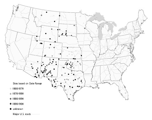 |
Figure 1. Significant Historic Sites Associated With Buffalo Soldier Regiments. Howard University students identified the location of the 215 Buffalo Soldier sites in the United States. The locations are classified by date range corresponding to their period of significance. (Courtesy of CRGIS, National Park Service.) |
Subsequently, CRGIS helped the Howard University students use the geographic data and GIS to make maps showing the distribution of sites in the West associated with the Buffalo Soldiers. Because of the information contained in the attribute tables, students performed some basic analysis, such as color-coding the sites by date range, unit, and opponent. Through GIS, students also explored the level of protection for each resource by overlaying the site locations on national park or federal land boundaries.(Figure 2)
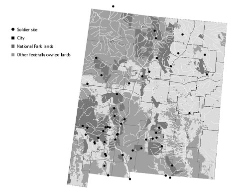 |
Figure 2. Sites Associated With Buffalo Soldiers In New Mexico. This map shows Buffalo Soldier sites in New Mexico overlaid with national park lands and other federally owned lands. (Courtesy of CRGIS, National Park Service.) |
Maps and data produced by the Howard and Haskell students contributed to a report submitted by the universities to the National Park Service in 2004. Both groups of students found the project rewarding and informative, giving them opportunities to explore aspects of each other's cultures that they may never have previously considered.
The Future of the Warriors Project
The success of the Warriors Project may lead to additional work highlighting the lives and contributions of both African Americans and American Indians during the 19th century. Certainly, the information collected during the Warriors Project calls for more research to find the 35 sites for which no location could be determined. Students could look to other technologies such as Global Positioning Systems (GPS) to pinpoint these critical resources with more accuracy. By incorporating other technologies, students could interview tribal elders, collect oral traditions, and associate that information with specific geographic locations. Tied with traditional documentary sources, this information could be linked for the first time through GIS.
Similarly, the Warriors Project calls for a more systematic survey of resources associated with the Buffalo Soldiers, to assess potential threats to these sites and to recognize where they are already protected. The National Park Service's American Battlefield Protection Program conducted comprehensive surveys of this type for the Civil War, the War of 1812, and the Revolutionary War, which could serve as models. Building on the work already completed and taking advantage of the technological tools available, this type of study for Warriors Project sites would significantly contribute to scholarship in this area, as well as the protection of these often overlooked sites. Such a project could increase communication between the American Indian and African American communities as they work to identify more sites and survey known sites.
Finally, the Warriors Project will lead to more professional interest in these resources and raise public awareness of the contributions of these combatants in the history of the American West. Recent archeological investigations, funded by the Desert Southwest CESU through the National Park Service and the Bureau of Land Management, are addressing military sites identified during this project, such as the Guadalupe Mountains base camp in Texas. The Intermountain Region's Colorado Plateau and Rocky Mountain CESUs joined the effort and began to explore possibilities for archeological field schools and theme studies. Studies focusing on the Villista Campaigns on the United States-Mexican border and the conflicts of African American troops with border guerillas during the Mexican Revolution of 1910 are also being explored. Heritage tourism continues to play an important role as state departments of tourism work with tourism organizations to develop and market tours.
Through the application of technologies such as GIS, students can create maps to make powerful statements that can be used in state, local, and federal preservation planning processes and can help to promote the protection of these sites and raise public awareness of local history. These technologies offer additional tools to historians and students, promoting more informed scholarship. The dynamic and flexible nature of GIS will help to tell the important story of diverse peoples and their roles in American history.
About the Author
Deidre McCarthy is a GIS specialist with the Cultural Resource Geographic Information Systems Facility, a component of the National Park Service Historic American Buildings Survey/Historic American Engineering Records/ Historic American Landscapes Survey/Cultural Resources Geographic Information Systems Program. She can be reached at deidre_mccarthy@nps. gov.
Note
1. Cooperative Ecosystem Studies Units (CESUs) are formal partnerships among federal agencies and universities to provide research, technical assistance, and education on the biological, physical, social, and cultural sciences to federal land management, environmental, and research agencies and their potential partners. CESUs address natural and cultural resource issues and interdisciplinary problem solving in an ecosystem context.