
Research Report
Historic American Buildings Survey: North Carolina Audit
by Martin J. Perschler
The National Park Service's Historic American Buildings Survey (HABS) has produced one of the largest architectural archives in the world. Since it was established in 1933, HABS has documented over 25,000 structures and sites in a combination of measured drawings, large-format photographs, and written historical reports, all of which are on permanent deposit at the Library of Congress and are available to the public. As a quantitative measure of its success at upholding the principle of preservation through documentation, the number of documented sites that have entered the HABS collection since the 1930s (more than 300,000 items in all) is also one of HABS's reddest herrings: While a reliable indicator of HABS's activity across the country, the number of recorded sites sheds little light on the quality of the documentation produced by HABS or on HABS's success at meeting one of its chief goals: to serve as a "complete resume of the builders' art."(1)
Recent changes at the HABS/HAER/HALS/CRGIS (Historic American Buildings Survey/Historic American Engineering Record/Historic American Landscapes Survey/Cultural Resources Geographic Information Systems) Program have made it possible to extract new information from the collections. An effort begun in 2001 to catalog all HABS records has already led to a clearer understanding of the range of building types documented by the program since 1933. The introduction of Geographic Information Systems (GIS) as another collections management tool in the spring of 2004 has contributed towards creating a more accurate and meaningful picture of HABS's work. Time and again, cataloging and GIS are proving their mettle as highly effective tools for measuring HABS's progress and charting new courses and documentation priorities.
In the summer of 2004, HABS/HAER/HALS/CRGIS combined cataloging and GIS in a pilot study—an audit—of HABS documentation. Using the HABS records on sites in North Carolina, Romola Ghulamali, a student at the University of Maryland and a participant in the National Park Service's Cultural Resources Diversity Internship Program, and I completed several significant cataloguing tasks. We catalogued close to 400 HABS records; cross-checked them against North Carolina's lists of National Historic Landmarks and state historic sites; consulted architectural guidebooks for information on the architectural character and history of the state's three distinct geographical regions; searched HABS's administrative history files for correspondence, lists, and other records relating to HABS's first efforts in the state; and consulted with the North Carolina State Historic Preservation Office for information on current surveying and other preservation priorities. We used GIS to represent the distribution of recording activities and to locate landmarks, historic sites, and other buildings and building types that might be considered suitable for future surveys.
While some of the North Carolina audit findings are predictable given the way in which HABS has evolved as a program over the years, others are unique to North Carolina. For instance, nearly 30 percent of the HABS records for North Carolina now at the Library of Congress can be attributed to one man. Thomas T. Waterman (1900-1951), an associate architect for HABS and supervisor of recording efforts along the eastern seaboard from 1933 to 1942, photographed and researched over 100 buildings and sites in North Carolina during a three-week trip through the state in July 1940, a remarkable achievement even by today's standards. His keen personal interest in the state's early domestic architecture—an interest he cultivated while working for HABS and the driving force behind his July adventure—resulted in a beautifully illustrated book on the subject in collaboration with photographer Frances Benjamin Johnston, and an abundance of photo documentation of 18th- and early-19th-century houses in the HABS collection.(2) His interests likewise led to the establishment of an architectural canon for North Carolina in which houses occupy center stage.(Figure 1)
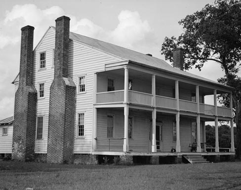 |
Figure 1. Sandy Point Plantation, Chowan County, North Carolina, taken July 1940, is one of many photographs made by Thomas T. Waterman. (Courtesy of the Library of Congress, Prints and Photographs Division.) |
While the HABS collection includes records of buildings from each region of the state, half are (or were) located in eastern North Carolina, where Waterman focused most of his energy. Although the North Carolina records represent a wide variety of building types (114 different types), frame and brick houses predominate, accounting for 61 percent of the North Carolina buildings and sites recorded by HABS. While not surprising considering Waterman's interests and those of HABS, that figure exceeds current estimates of the number of houses in the HABS collection overall (37 percent, based on a sampling of approximately 6,000 records, or 20 percent of the collection). By comparison, only 1 percent of buildings recorded in North Carolina may be classified as barns, whereas collection-wide the figure approaches 8 percent. In a state where agricultural roots run deep, a dearth of recorded barns is as good an indicator as any of the direction HABS might consider the next time it heads to the Tar Heel State.
Approximately 25 percent of the North Carolina records includes a measured drawings component, matching the average for the HABS collection overall. One third of the drawing sets are the work of students in the School of Design at North Carolina State University (previously North Carolina State College), who measured and drew 32 buildings and sites for HABS during the 1960s and 1970s. The number of photographs and historical data per report are below the collection average. Such lower figures are due in large part to the cursory nature of recording activities in the state from 1933 to 1940.
Forsyth County in the North Carolina Piedmont leads other counties in the number of recorded sites, with several of them located in the 18th-century Moravian settlement of Old Salem (part of today's Winston-Salem). Following Forsyth are Craven and Chowan Counties along the Atlantic coast, where the recorded sites—many of them photographed by Waterman—are located either in or around the 18th-century county seats of New Bern, founded in 1710, and Edenton, founded in 1715.(Figure 2)
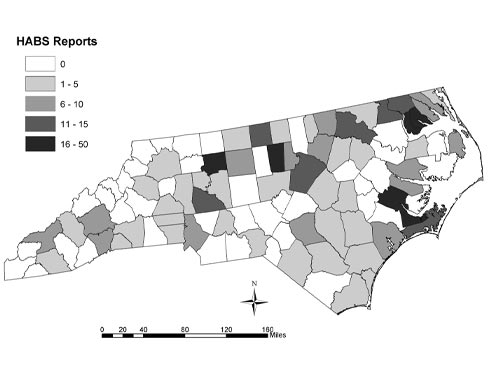 |
Figure 2. North Carolina HABS REPORTS, August 2004. This map of North Carolina illustrates the concentration of properties per county represented in the HABS collection as of August 2004. (Courtesy of the National Park Service.) |
National parks account for approximately 6 percent of the North Carolina records in the HABS collection. More than half (64 percent) of those records are associated with parks in the Blue Ridge Mountains or the Appalachian foothills, where they represent 44 percent of all HABS records for the region. According to current statistics, HABS has recorded 47 percent of North Carolina's 38 National Historic Landmarks, 11 percent of its 27 state historic sites, and at least 1 building or site in 58 of the state's 100 counties.
Possibilities for new recording projects abound in North Carolina, whether the projects take a geographical tack, fall along typological lines (say, a tobacco barn survey), or follow a thematic approach (a National Historic Landmarks recording project, for example). Architectural interests have evolved since the 1930s, the field of eligible survey candidates has drastically expanded, and many buildings and sites once thought to be safe from destruction—or not thought of at all—now face uncertain futures as population shifts, commercial and residential development, natural disasters, and sweeping transformations in agriculture and traditional industries press against North Carolina's historic architectural fabric. The measure of HABS's success in North Carolina and elsewhere over the next 70 years may be the extent to which HABS is able to keep ahead of these changes.
The collections management team at HABS/HAER/HALS/CRGIS is now applying the lessons of the North Carolina audit to other states. A report looking at the track records of both HABS and its sister program, the Historic American Engineering Record (HAER), in Colorado is scheduled for December 2004.(Figure 3) Reports on Arizona, Maine, the Dakotas, and Oklahoma will follow.
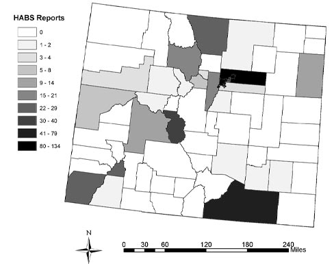 |
Figure 3. Colorado, December 2004. This map of Colorado illustrates the concentration of properties per county represented in the HABS collection as of October 2004. (Courtesy of the National Park Service.) |
About the Author
Martin J. Perschler is collections manager with the HABS/HAER/HALS/ CRGIS Program and the photographic collections editor for the CRM Journal. He can be reached at martin_perschler@nps.gov.
Notes
1. Charles E. Peterson, "Memorandum for the Director, Office of National Parks, Buildings, and Reservations," November 13, 1933, as reprinted in "American Notes," Journal of the Society of Architectural Historians 16, no. 3 (October 1957): 30. See also Lisa Pfueller Davidson and Martin J. Perschler, "The Historic American Buildings Survey During the New Deal Era: Documenting 'a Complete Resume of the Builders' Art'," CRM: The Journal of Heritage Stewardship 1, no. 1 (Fall 2003): 49-73.
2. Frances Benjamin Johnston and Thomas T. Waterman, The Early Architecture of North Carolina (Chapel Hill: University of North Carolina Press, 1947).