")
NPS photo
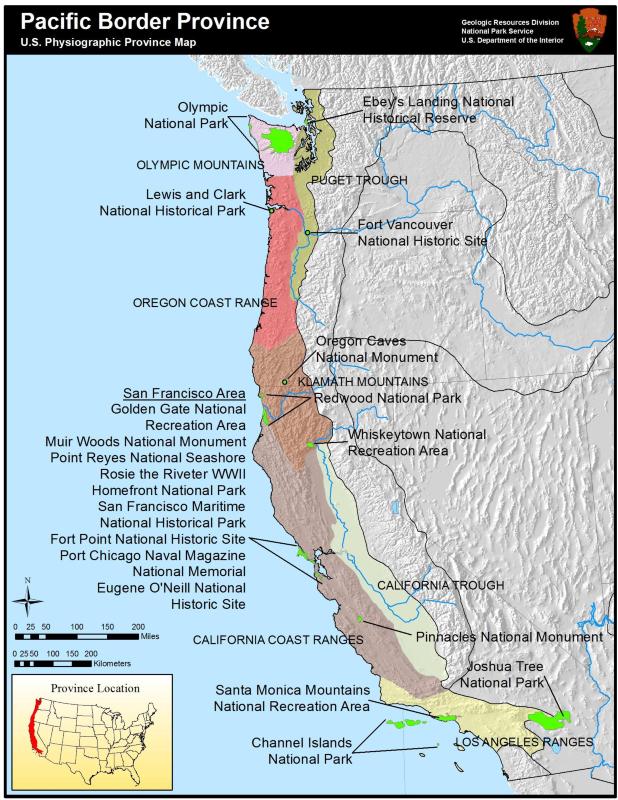
The Pacific Border Province is a long region running along the western margin of the United States, as the name implies. It can be divided into two distinct types of topography: lowlands and mountains. The lowlands are in the form of a trough on the eastern side of the region, separated in the middle by the Klamath Mountains. The Puget trough slopes to the north, eventually plunging into the waters of Puget Sound. It was covered by ice during the Pleistocene and is underlain by glacial deposits. The California trough to the south is underlain by alluvial sediments and is one of the world’s most productive agricultural areas.
The various mountain ranges of the Pacific Border Province trend north-south, except for the aptly-named Transverse Ranges which trend east-west. The Transverse Ranges are also the most variable range in rock type and elevation. In the west, the Transverse Ranges are largely Tertiary sedimentary beds upon Mesozoic and older rocks. Toward the east are older and more complex metamorphic rocks with large granitic intrusions. The elevation ranges from 900 m (3,000 ft) to more than 3,000 m (10,000 ft).
The Olympic Mountains in the northern extent of the province are the most rugged of the coastal ranges, with an average elevation of 1,500 m (5,000 ft), and valleys that have been deepened by glaciers. The tallest peak is Mt Olympus at 2.4 km (7,965 ft). The rocks of the Olympic Mountains are sandstones, shales, conglomerates and basalts of Cenozoic age that have been metamorphosed to slates, phyllites, and greenstone. South of the Olympics are the Oregon Coast Ranges, made of Tertiary sandstones, shales, and limestones intruded by igneous bodies.
The California Coast Ranges are Cretaceous sedimentary and metamorphic rocks with Mesozoic granitic intrusions. These mountains have been deformed by ongoing faulting, including the well-known San Andreas Fault zone.
Higher and more rugged than either of the Coast Ranges above and below, the Klamath Mountains are hard metamorphic Paleozoic rocks with Mesozoic beds of sedimentary rocks and volcanics present. The Klamath Mountains connect the mountains of the Pacific Border Province with the Sierra Nevada Mountains to form a crude letter ‘H.’
The Pacific Border Province includes several National Parks. Olympic National Park covers 900,000 acres of designated wilderness and includes the most rugged portion of the Olympic Mountains, including the peaks of Mt Olympus, Mt Tom, Mt Anderson, Mt Constance and Mt Mystery. Redwood National Park is home to the three tallest trees on the planet; Howard Libbey Tree, Harry W. Cole Tree, and National Geographic Tree all tower over 110 m (360 ft) above the forest floor. Channel Islands National Park is the submerged continuation of the Santa Monica Mountains in the Pacific Ocean. Additionally, Point Reyes north of San Francisco has been designated a National Seashore.
Beyond the scenic value of the Pacific Border Province, which also includes the Rancha La Brea Tar Pits and Santa Catalina Island, the region is home to several mineral resources. Gold has famously been an important part of Californian history and cultural development. On- and offshore drilling make California the second most prolific oil producing state in the lower 48 United States.
")
NPS photo/Dan Wells
Educational Resources
Freeing the Elwha:
As rivers carry sediment to the sea, different sediment structures are formed along shorelines; how is sediment important to both river and the shoreline ecosystems? The focus of this lession is depositional and erosional effects as rivers meet the sea.
The building of the Elwha River Dams has had a huge effect on the natural sediment transport and sediment structures along the Strait of Juan de Fuca. What benefit will the removal of the dams have to natural and human communities along the Strait of Juan de Fuca as natural sediment transport resumes?
Subduction Construction Game
Journey into the Subduction Zone to solve the geologic mystery of how the rocks you see in the cliffs of the Golden Gate formed millions of years ago. In this virtual exploration, students will collect rock samples in the field; examine and identify their samples in the laboratory; and piece together the subduction zone, layer-by-layer in geologic context.
Redwood EdVentures
Redwood EdVentures connects students, parents, and teachers with all things fun and fascinating related to the California Coastal Redwoods.

NPS photo
Pacific Border Parks
- Channel Islands National Park, California [Geodiversity Atlas] [Park Home]
- Ebey's Landing National Historical Reserve, Washington [Geodiversity Atlas] [Park Home]
- Eugene O'Neill National Historic Site, California [Geodiversity Atlas] [Park Home]
- Fort Point National Historic Site, California [Geodiversity Atlas] [Park Home]
- Fort Vancouver National Historic Site, Oregon & Washington [Geodiversity Atlas] [Park Home]
- Golden Gate National Recreation Area, California [Geodiversity Atlas] [Park Home]
- Joshua Tree National Park, California [Geodiversity Atlas] [Park Home]
- Lewis and Clark National Historical Park, Oregon & Washington [Geodiversity Atlas] [Park Home]
- Muir Woods National Monument, California [Geodiversity Atlas] [Park Home]
- Olympic National Park, Washington [Geodiversity Atlas] [Park Home]
- Oregon Caves National Monument, Oregon [Geodiversity Atlas] [Park Home]
- Pinnacles National Monument, California [Geodiversity Atlas] [Park Home]
- Point Reyes National Seashore, California [Geodiversity Atlas] [Park Home]
- Port Chicago Naval Magazine National Memorial, California [Geodiversity Atlas] [Park Home]
- Redwood National Park, California [Geodiversity Atlas] [Park Home]
- Rosie the Riveter WWII Homefront National Park, California [Geodiversity Atlas] [Park Home]
- San Francisco Maritime National Historical Park, California [Geodiversity Atlas] [Park Home]
- Santa Monica Mountains National Recreation Area, California [Geodiversity Atlas] [Park Home]
- Whiskeytown National Recreation Area, California [Geodiversity Atlas] [Park Home]
Part of a series of articles titled Physiographic Provinces.
Previous: Ouachita and Ozark Plateaus Provinces
Next: Piedmont Province
Tags
- channel islands national park
- ebey's landing national historical reserve
- eugene o'neill national historic site
- fort point national historic site
- fort vancouver national historic site
- golden gate national recreation area
- joshua tree national park
- lewis and clark national historical park
- muir woods national monument
- olympic national park
- oregon caves national monument & preserve
- pinnacles national park
- point reyes national seashore
- port chicago naval magazine national memorial
- redwood national and state parks
- rosie the riveter wwii home front national historical park
- san francisco maritime national historical park
- santa monica mountains national recreation area
- whiskeytown national recreation area
- geology
- physiographic province
- coast
- education
- redwood national and state parks
- subduction
- california
- washington state
- oregon
- physiog
- pacific border province
Last updated: May 7, 2020