Last updated: December 29, 2022
Article
Stratotype Inventory—Grand Teton National Park, Wyoming
NPS photo.
Introduction
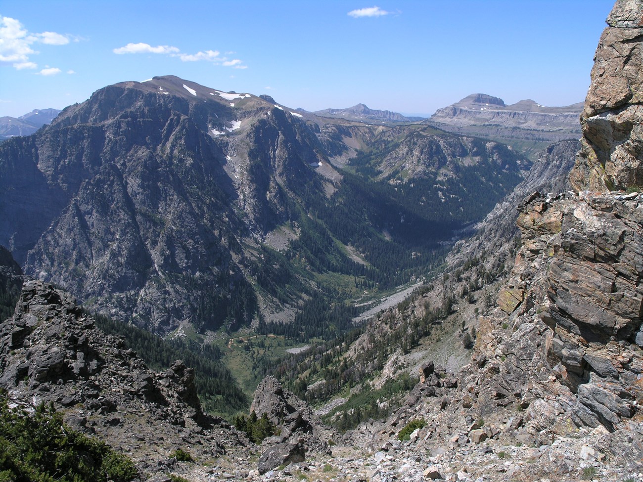
Grand Teton National Park (GRTE), located in Teton County, Wyoming, was established on February 26, 1929 and features the rugged, iconic peaks of the Teton Range, the expansive valley of Jackson Hole, and the scenic Snake River (Figure 9). Congress enlarged the boundaries of GRTE on September 14, 1950 to incorporate much of the Jackson Hole National Monument, increasing the park area to 125,270 hectares (310,044 acres) (Anderson 2017). Located in northwestern Wyoming, the park is situated within one of the world’s largest intact temperate ecosystem that is home to diverse wildlife, including grizzly bears, wolves, bison, moose and elk (Anderson 2017). For centuries the Teton Range has served as an important landmark for Native Americans, trappers, prospectors, explorers, scientists, and tourists. Today, more than 2 million visitors come to the park annually to experience its spectacular landscape.
The dramatic landscape of GRTE has been sculpted by dynamic geologic processes to create a variety of geothermal, glacial, and volcanic features in addition to Snake River terrace deposits. The spectacular topography and scenery of the Teton Range is the result of plate tectonics and the active Teton fault, a normal fault extending more than 70 km (40 mi) from north to south along the eastern base of the range (KellerLynn 2010). Tectonic forces along the Teton fault have raised the Teton Range and dropped Jackson Hole to create more than 2,100 m (6,900 ft) of topographic relief. Exposed rock units in GRTE represent a vast range in age from Archean (4.0–2.5 billion years ago) (see The Precambrian) to Quaternary (2.6 million years ago–Present) (see Cenozoic Era). The Teton Range consists of an uplifted core of igneous and metamorphic Archean and Proterozoic rocks surrounded by Paleozoic and Mesozoic sedimentary rocks. Younger Cenozoic deposits dominate the land surface immediately east of the core in Jackson Hole (Figures 10 and 11).
NPS image.
Significance and Geologic Resource Values
The Grand Teton National Park and John D. Rockefeller, Jr. Memorial Parkway Foundation Document (2017) references the following significance statement: “Grand Teton National Park preserves the landscape of one of the world’s most impressive and highly visible fault block mountain ranges that abruptly rises up to 7,000 feet above the valley floor along an active fault (the Teton Fault) formed from the collision of tectonic plates. The range is juxtaposed with landscapes shaped by glacial processes and braided river geomorphology. The Teton Range is one of the continent’s youngest mountain ranges, yet exposes some of the oldest rocks on earth.”
The following fundamental resources and values have been identified for GRTE and JODR: “Geologic Features and Processes. Powerful ongoing geologic forces shape the park, parkway, and nearby Yellowstone National Park. Regional heat from the earth’s mantle combined with local heat from the plume of magma under Yellowstone have lifted and cracked the earth’s crust. Earthquakes generated along one of these cracks–the Teton fault–tilted the Teton Range skyward while dropping the valley of Jackson Hole. As the mountains were rising, massive glaciers flowed south from Yellowstone and alpine glaciers carved out U-shaped canyons and piedmont lakes ringed by glacial moraines. The glaciers melted, washing soil from the valley floor, and leaving behind an outwash plain covered with cobbles and carving terraces that step down to the modern Snake River. Today, small earthquakes occasionally shake the region, suggesting the power of future mountain-building. Remnant glaciers serve as reminders of the powerful and massive glaciers that shaped the landscape. All the while, rainfall and freeze-thaw cycles cause landslides and rockfalls.”

NPS Geologic Resources Inventory base map.

NPS Geologic Resources Inventory.
Stratotypes in Grand Teton
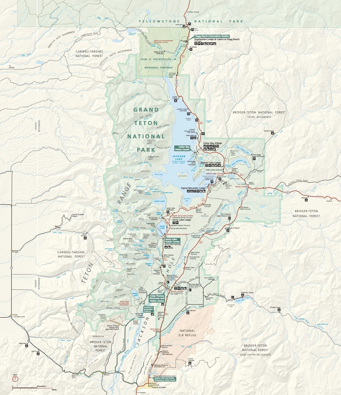
At the time of the writing of this report, Grand Teton is known to contain four stratotypes that include two type localities and two type sections (see Table below; Figure 12).
| Unit Name (map symbol) | Reference | Stratotype Location | Age |
|---|
Geologic Time Scale
Location Map

NPS Geologic Resources Inventory base map.
The two GRTE type localities are the upper Archean Webb Canyon Gneiss and lower Proterozoic Mount Owen Quartz Monzonite, some of the oldest exposed geologic units in the park. Reed and Zartman (1973) characterized the Webb Canyon Gneiss as a medium- to coarse-grained, strongly foliated, non-layered, biotite-and-hornblende-bearing gneiss of quartz monzonitic composition that forms several large concordant bodies in the northern part of the Teton Range. The type locality is designated as the lower parts of the cliffs on the northwest side of Moose Creek in the lower part of Webb Canyon, 3.1 km (1.9 mi) S. 78° E. of Owl Peak in the Ranger Peak 7.5’ quadrangle, Wyoming (Figure 12; Reed and Zartman 1973). The type locality is situated near the northeast end of the largest exposed body of the Webb Canyon Gneiss where is has thick amphibolite layers.
The Mount Owen Quartz Monzonite is named from exposures on the slopes of Mount Owen and is described as an irregular pluton of light-colored quartz monzonite and associated pegmatite that underlies much of the central Teton Range (Reed and Zartman 1973). Typically the Mount Owen Quartz Monzonite is a medium- to fine-grained light-colored rock consisting of 30–40% quartz, 20–30% K (potassium)-feldspar, 25–35% Na (sodium)-plagioclase (oligoclase), 5% or less biotite, and trace amounts of muscovite (Reed and Zartman 1973). Associated pegmatite bodies range in thickness from several cm (a few inches) to several tens of meters or feet throughout the main body of the Mount Owen Quartz Monzonite. The pegmatites contain irregular masses of quartz, oligoclase, microcline, and muscovite; a few pegmatites contain garnet crystals up to 15 cm (6 in) in diameter (Reed and Zartman 1973). Reed and Zartman (1973) designated the type locality as the more easily accessible exposures along the trail in the South Fork of Cascade Canyon at an elevation of 2,700 m (8,880 ft), 3.1 km (1.9 mi) due west of the summit of Mount Owen, Grand Teton 7.5’ quadrangle, Wyoming (Figure 12).
The oldest type section unit of GRTE is the Cambrian Death Canyon Limestone Member of the Gros Ventre Formation. The Death Canyon Limestone Member occurs stratigraphically above the Wolsey Shale and beneath the Park Shale, and consists largely of thin-bedded, fine-grained, dark-gray, brown and black mottled limestone separated by argillaceous seams (Figure 13; Miller 1936; Shaw 1957). Miller (1936) designated the type section location as being along the divide between the South Fork of Teton Canyon and Death Canyon in the Teton Range, about 3 km (2 mi) south of Buck Mountain (Figure 12). At the type occurrence the limestone is approximately 86.9 m (285 ft) thick and forms a prominent, double-rimmed scarp (Figure 14).
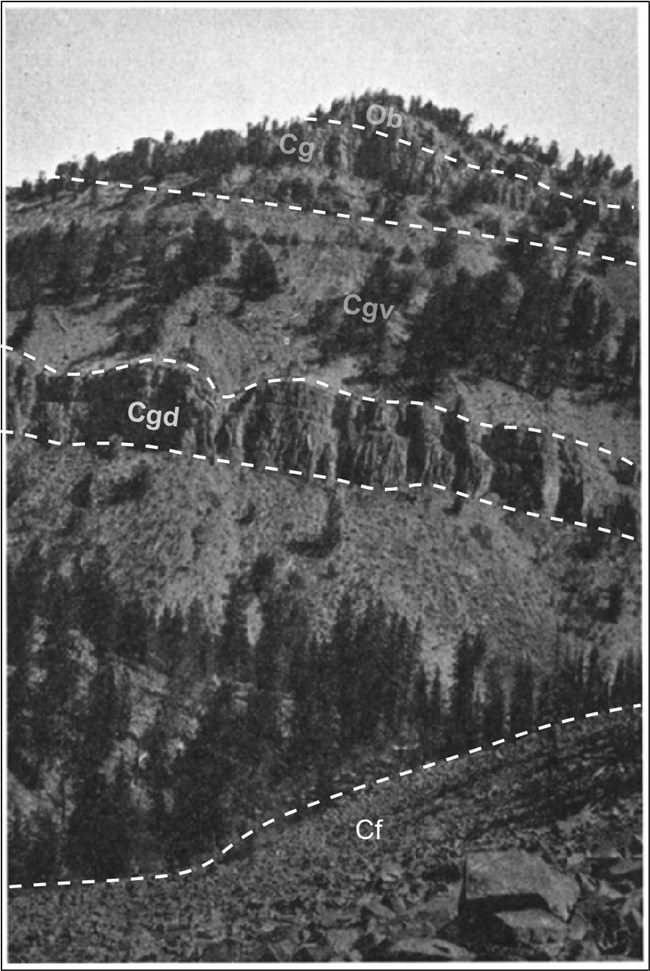
Figure 13. Section along Warm Springs Creek in the Teton Range, Wyoming. The blocks in the foreground are Flathead Sandstone (Cf); the prominent lower cliff is the upper part of the Death Canyon Limestone Member of the Gros Ventre Formation (Cgd). The contact between the Gros Ventre Formation (Cgv) and Gallatin Limestone (Cg) is just above the base of the second cliff above the Death Canyon Limestone; the Gallatin Limestone–Bighorn Dolomite (Ob) contact is in the middle part of the cliff capping the hill. Figure modified from Miller (1936) (figure courtesy David Rowley/Journal of Geology).
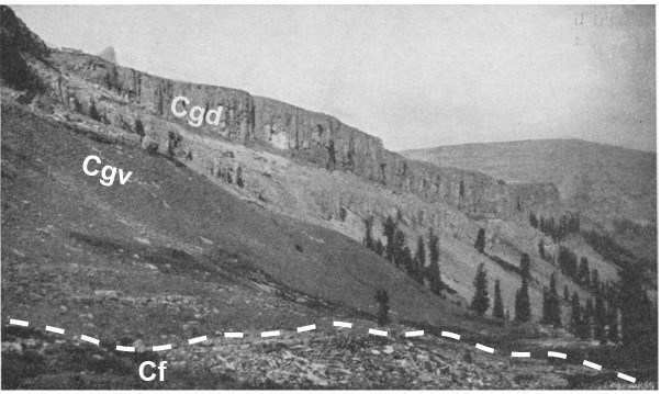
Figure 14. Type section of the Death Canyon Member of the Gros Ventre Formation, 3 km (2 mi) south of Buck Mountain, in the South Fork of Teton Canyon, GRTE. The double-rimmed scarp is the Death Canyon Member (Cgd) atop the shaly slopes of the lower Gros Ventre Formation (Cgv); the blocks in the foreground are at the top of the Flathead Sandstone (Cf). Figure modified from Miller (1936) (figure courtesy David Rowley/Journal of Geology).
The second GRTE type section is the Miocene-age (Neogene Period) Colter Formation, which is based on a 2,100-m (7,000-ft) sequence of gray, green, and brown pyroclastic rock, sandstone, and claystone near Colter Bay, Wyoming (Love 1956). The Colter Formation is characterized by abundant lithic fragments consisting of red, black, and green angular- to sub-rounded basalt found in tuffs and conglomerates (Love 1956). Deposits of the formation were later classified as pyroclastic flow, lahar, surge, and coarse air-fall deposits that were erupted from vents mainly in the northwest part of Jackson Hole (Barnosky 1984; Barnosky and Labar 1989). Love (1956) described the type section location as extending eastward from the east face of Pilgrim Peak across Pilgrim Creek for a distance of about a mile, within Sections 20, 21, and 22, and 27, 28, and 29, Township 46 North, Range 114 West, in Teton County, Wyoming. Exposures in the vicinity of the type section on Pilgrim Creek are the thickest, where 2,100 m (7,000 ft) of strata were measured with the exception of the basal part of the formation, which was distorted by intrusions and landslides (Figure 12; Love 1956). Barnosky (1984) defined type sections of the Crater-Tuff Breccia Member and Pilgrim Conglomerate Member of the Colter Formation, stating that the composite of the two member type sections is the type section reported by Love (1956) for the Colter Formation.
In addition to the designated stratotypes located within GRTE, a list of stratotypes located within 48 km (30 mi) of park boundaries is included here for reference. These nearby stratotypes include the Eocene (Paleogene Period) Hominy Peak Formation (type section) and the Devonian Darby Formation (type section).
Type Section Inventory Report—Greater Yellowstone Inventory & Monitoring Network
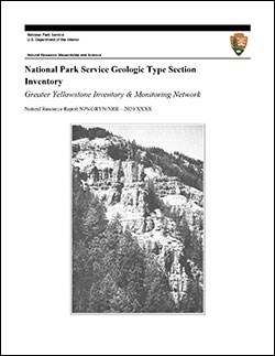
The information on this page is excerpted from a report covering four parks within the Greater Yellowstone Inventory and Monitoring Network (GRYN):
The full Network report is available in digital format from https://irma.nps.gov/DataStore/Reference/Profile/2280034
Please cite this publication as:
Henderson, T., V. L. Santucci, T. Connors, and J. S. Tweet. 2020. National Park Service geologic type section inventory: Greater Yellowstone Inventory & Monitoring Network. Natural Resource Report NPS/GRYN/NRR—2020/2198. National Park Service, Fort Collins, Colorado.
Leave No Trace—Protect Type Sections for Science

Many type sections and paleontological sites are vunerable to damage from careless visitation and over-use. Be sure to practice Leave No Trace princples whenever you are in the outdoors. Of particular importance at geoheritage sites is to:
-
Travel and camp on durable surfaces, and
-
Leave what you find.
If you see signs of vandalism or someone acting inappropriately during your visit to a park site, please contact a ranger at the park or make a report through NPS Investigative Services.
Related Links
- Grand Teton National Park, Wyoming—[Geodiversity Atlas] [Park Home] [NPSHistory.com]
- Geologic Time Scale
- America's Geoheritage
- NPS Paleontological Resource Inventory
- NPS Geologic Resources Inventory
- NPS Geodiversity Atlas
