Backcountry Trails

Two hikers stand next to a towering rock cliff with green foliage framing them.
Bluffs Trail

NPS Photo/Anya Gupta

The wild, rugged forest calls to adventurers today, just as it called to people millennia ago. At 37 square miles of forest ridges, valleys, and scenic rivers vistas, the backcountry provides the perfect place for a journey on foot.
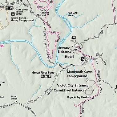
 
Trail Starts at Mi. Km.
Big Hollow Trail North Loop Big Hollow TH 5.3 8.6
Big Hollow Trail North Loop Shortcut Big Hollow Trail North Loop 0.1 0.2
Big Hollow Trail South Loop Big Hollow Trail North Loop Junction 3.7 6.0
Blair Springs Hollow Trail Collie Ridge Trail/ Wet Prong Trail 1.8 2.9
Bluffs Campsite Trail Sal Hollow Trail 0.6 1.0
Buffalo Creek Trail Maple Springs TH 4.4 7.0
Collie Ridge Trail Lincoln TH 3.8 6.2
Collie Ridge Campsite Trail Collie Ridge Trail 0.7 1.1
Dry Prong Trail Buffalo Creek Trail 2.4 3.9
Ferguson Campsite Trail Blair Springs Hollow Trail 0.5 0.9
First Creek Trail First Creek TH/Temple Hill TH 6.3 10.2
First Creek Campsite 1 Trail First Creek Trail 0.3 0.5
First Creek Campsite 2 Trail First Creek Trail 0.1 0.1
Homestead Campsite Trail Dry Prong Trail 0.3 0.4
Maple Springs Trail Maple Springs TH 1.0 1.6
Maple Springs Campground Trail Maple Springs Trail 0.2 0.3
McCoy Hollow Trail Temple Hill TH/ Wet Prong Trail 6.4 10.3
McCoy Hollow Campsite Trail McCoy Hollow Trail 0.1 0.2
Miles-Davis Cemetery Trail Sal Hollow Trail 0.4 0.6
Mill Branch Trail Maple Springs Trail/Collie Ridge Trail 3.0 4.7
Raymer Hollow Trail Mill Branch Trail/ Collie Ridge Trail 6.2 9.9
Raymer Hollow Campsite Trail Raymer Hollow Trail 0.1 0.2
Sal Hollow Trail Maple Springs TH 8.6 13.8
Sal Hollow Campsite Trail Sal Hollow Trail 0.1 0.2
Second Creek Campsite Trail First Creek Trail 0.2 0.3
Stables Trail Collie Ridge Trail 0.2 0.4
Three Springs Campsite Trail McCoy Hollow Trail 0.1 0.1
Turnhole Bend Trail Buffalo Creek Trail 1.8 2.9
Wet Prong Trail First Creek TH/ Collie Ridge Trail 4.6 7.4
White Oak Trail White Oak TH 2.5 4.0


Download Maps

To download official maps in PDF, Illustrator, or Photoshop file formats, visit the National Park Service cartography site.


Planning your Backcountry Hike

Prepare for the season and weather and remember to pack the 10 essentials for any hike. At Mammoth Cave National Park, one of the most common safety concerns while hiking may be ticks, read more on backcountry health and safety. And as always, remember to follow the Leave No Trace Principles.

While many hikers find the backcountry perfect for a day hike, others extend their adventure by camping at one of the thirteen backcountry campsites or setting up a campsite at the Maple Springs Campground. Backcountry camping is available by permit.

Backcountry maps are available in the visitor center or at the Headquarters Campground Kiosk. If you have more questions about park trails, email us or call us at (270)758-2180.

 
  • Map of Mammoth Cave National Park
    Park Maps

    Up-to-date maps of Mammoth Cave National Park

  • A basic campsite surrounded by green trees.
    Backcountry & Riverside Camping

    Rugged undeveloped tent sites, horseback sites, and paddle-in riverside sites.

  • Bikes on a rack on the back of a car
    Bicycling

    Hit the trails and experience the park on two wheels.

  • Close shot of horse standing in a brightly wooded area.
    Saddle up!
    Horseback Riding

    Those who love to see the world from horseback are in luck! Explore 60 miles of backcountry trails suitable for many skills and ages.

  • Dog rolling around in the lush grass.
    Pets in the Park

    Tips for a great visit with your pet.

  • The park's entrance sign, surrounded by yellow, orange and red fall leaves.
    Directions

    Getting to Mammoth Cave National Park – from wherever you are. Plus, coordinates for your navigation device.

Last updated: December 5, 2022

Park footer

Contact Info

Mailing Address:

P.O. Box 7
Mammoth Cave, KY 42259-0007

Phone:

270 758-2180

Contact Us