
NPS/Jim Peaco Observe Tower FallThe 132-foot (40-m) drop of Tower Creek, framed by eroded volcanic pinnacles has been documented by park visitors from the earliest trips of Europeans into the Yellowstone region. Its idyllic setting has inspired numerous artists, including Thomas Moran. His painting of Tower Fall played a role in the establishment of Yellowstone National Park in 1872. The nearby Bannock Ford on the Yellowstone River was an important travel route for early Native Americans, as well as for early European visitors and miners up to the late 19th century. 
NPS/Jim Peaco Take in the Yellowstone RiverCalcite Springs marks the downstream end of the Grand Canyon of the Yellowstone River. The geothermally altered rhyolite inspired the artist Thomas Moran. His paintings of this scene were among those presented to Congress in 1872, leading to the establishment of the park. The steep, columnar basalt cliffs on the opposite side of the river from the overlook are remnants of an ancient lava flow, providing a window into the past volcanic forces that shaped much of the Yellowstone landscape. The gorge and cliffs provide habitat for numerous wildlife species including bighorn sheep, red-tailed hawks, and osprey. For those looking to stretch the legs, there is the Yellowstone River Picnic Area Trail that follows the canyon edge on the other side of the river. This trail offers an alternative view of the terminus of the Grand Canyon of the Yellowstone River. Delve into the PastPetrified Tree, located near the Lost Lake trailhead, is an excellent example of an ancient redwood, similar to many found on Specimen Ridge, that is easily accessible to park visitors. Specimen Ridge, located along the Northeast Entrance Road east of Tower Junction, contains the largest concentration of petrified trees in the world. There are also excellent samples of petrified leaf impressions, conifer needles, and microscopic pollen from numerous species no longer growing in the park. Specimen Ridge provides a superb window into the distant past when plant communities and climatic conditions were much different than today. 
NPS/Jim Peaco Watch Wildlife in Lamar ValleyLamar Valley is an excellent place to view wildlife, with it being one of the major summer grounds for bison and elk, which attracts predators like wolves and grizzly bears. Remember: Do not approach or encircle bears or wolves on foot within 100 yards (91 m) or other wildlife within 25 yards (23 m). Always maintain a safe distance from all wildlife. Each year, park visitors are injured by wildlife when approaching too closely. 
NPS/Neal Herbert Learn at the Lamar Buffalo RanchThe Lamar Buffalo Ranch was built in the early part of the 20th century in an effort to increase the herd size of the few remaining bison in Yellowstone, preventing the feared extinction of the species. Buffalo ranching operations continued at Lamar until the 1950s. The valley was irrigated for hay pastures, and corrals and fencing were scattered throughout the area. Remnants of irrigation ditches, fencing, and water troughs can still be found. Four remaining buildings from the original ranch compound are contained within the Lamar Buffalo Ranch Historic District (two residences, the bunkhouse, and the barn) and are on the National Register of Historic Places. The facility is used in the spring and fall for the National Park Service's residential environmental education program, Expedition Yellowstone. You are welcome to drive by to view the historic buffalo ranch, however, there are no facilities open to the general public at this location. Glimpse the Bannock TrailThe Bannock Trail, once used by Native Americans to access the buffalo plains east of the park from the Snake River plains in Idaho, was extensively used from approximately 1840 to 1876. A lengthy portion of the trail extends through from the Blacktail Plateau (closely paralleling or actually covered by the existing road) to where it crosses the Yellowstone River at the Bannock Ford upstream from Tower Creek. From the river, the trail's main fork ascends the Lamar River splitting at Soda Butte Creek. From there, one fork ascends the creek before leaving the park. Traces of the trail can still be plainly seen in various locations, particularly on the Blacktail Plateau and at the Lamar-Soda Butte confluence. 
NPS/Jim Peaco Have Dinner at an Old West CookoutPleasant Valley was the sight of "Uncle John" Yancey's Pleasant Valley Hotel, one of the earliest lodging facilities in Yellowstone. The hotel and outbuildings were built between 1884 and 1893 and served early park visitors as well as miners passing through en route to the mining district near Cooke City. Currently, the site is used for "Old West" cookouts. None of the original buildings remain. Visit the Northeast Entrance Ranger StationThe Northeast Entrance Ranger Station was constructed in 1934–35 and is a National Historic Landmark. Its rustic log construction is characteristic of "parkitecture" common in the national parks of the west during that period. 
NPS/Jim Peaco Explore the Geologic HistoryAbsaroka volcanics, glaciation, and erosion have left features as varied as Specimen Ridge's petrified trees to the gorges along the Yellowstone River's Black Canyon and the Grand Canyon of the Yellowstone River. Mt. Washburn and the Absaroka Range are both remnants of ancient volcanic events that formed the highest peaks in the area. Ancient eruptions, perhaps 45–50 million years ago, buried the forests of Specimen Ridge in ash and debris flows. The columnar basalt formations near Tower Fall, the volcanic breccias of the towers themselves, and numerous igneous outcrops all reflect the volcanic history. Later, glacial events scoured the landscape, exposing the stone forests and leaving evidence of their passage across the area. The glacial ponds and huge boulders (erratics) between the Lamar and Yellowstone rivers are remnants left by the retreating glaciers. Lateral and terminal moraines are common in these areas. Such evidence can also be found in the Hellroaring and Slough creek drainages, on Blacktail Plateau, and in the Lamar Valley. The eroding power of running water has been at work here for many millions of years. The pinnacles of Tower Fall, the exposed rainbow colors of the Grand Canyon of the Yellowstone River at Calcite Springs, and the gorge of the Black Canyon all are due, at least in part, to the forces of running water and gravity. In the Lamar River Canyon lie exposed outcrops of gneiss and schist which are among the oldest rocks known in Yellowstone, perhaps more than two billion years old. Little is known about their origin due to their extreme age. Through time, heat and pressure have altered these rocks from their original state, further obscuring their early history. Only in the Gallatin Range are older outcrops found within the boundaries of the park. Stay HereThis region in the park has several options for staying overnight. Roosevelt Lodge right at Tower–Roosevelt provides cabin accommodations. Just south of there, at Tower Fall, is the Tower Fall campground. Heading out to the Northeast Entrance are the Slough Creek and Pebble Creek campgrounds. All three of these campgrounds are reservable campgrounds run by the National Park Service. For those wanting to stay in the backcountry, check out the backcountry sites that are available in the region. 
Camp in a Campground
Plan a night in one of twelve park campgrounds. 
Stay in a Lodge
Pick a lodge that's right for you and make a reservation early! 
Camp in the Backcountry
Enjoy the solitude of more than 300 backcountry campsites. Tower–Roosevelt and the Northeast Frequently Asked QuestionsThe area is named for its major waterfall, Tower Fall, which is named for the tower-like rock formations at its brink.
132 feet (40 m).
W.H. Jackson's photograph in 1871 clearly shows the boulder. For more than a century, visitors wondered when it would fall. It finally did in June 1986.
No, the lower part of the trail is closed because of severe erosion. You can walk past the Tower Fall Overlook for 0.75-mile (1.2-km), ending with a view of Tower Creek flowing into the Yellowstone River. If you have heart, lung, or knee problems, you may want to enjoy the view from the overlook.
The rock columns were formed by a basaltic lava flow that cracked into hexagonal columns as it slowly cooled. You can see other basalt columns at Sheepeater Cliff along the Gardner River between Mammoth and Norris.
Petrified Tree, west of Tower Junction, is an excellent example of an ancient redwood. Petrification of this and other trees occurred for two main reasons. They were buried rapidly by volcanic deposits and mudflows 45–50 million years ago, which minimized decay. The volcanic deposits also contributed high amounts of silica to the groundwater. Over time, the silica precipitated from ground water, filled the spaces within the trees' cells, and petrified the trees. In Yellowstone, glacial ice, running water, and wind have uncovered vast areas of petrified trees. With proper optical aids, you can see some of these areas from the road that follows the base of Specimen Ridge, east of Tower Junction. No, but President Theodore Roosevelt camped nearby during his visit to Yellowstone in 1903. The lodge opened in 1920. The area is registered as the Roosevelt Lodge Historic District. Contrary to popular belief, it was not President Roosevelt but President Ulysses S. Grant who signed the order that created Yellowstone National Park.
Many park researchers have used the fenced areas on the northern range to study the long-term effects of grazing by fencing out large herbivores. Researchers can use existing data from the permanent plots or collect new data.
Elk, bison, deer, and pronghorn thrive in the grasslands of this area, known as the northern range. In fact, some of the largest wild herds of bison and elk in North America are found here. The northern range is critical winter habitat for these large animals, which in turn provide food for several packs of wolves. Coyotes are also common, and occasional bobcat, cougar, or red fox are reported. The gorge and cliffs between the junction and Tower Fall provide habitat for bighorn sheep, osprey, peregrine falcons, and red-tailed hawks. Both grizzly and black bears are sighted throughout the area, particularly in the spring. Black bears are more commonly seen around Tower Fall and Tower Junction. Grizzlies are sometimes seen in the Lamar Valley and on the north slopes of Mount Washburn, particularly in the spring when elk are calving. Moose are most often observed between Pebble Creek and the Northeast Entrance. Road pullouts provide excellent places from which to watch wildlife. 
Tower & Northeast Hikes
Explore valleys, mountains, and petrified forests in the northeast part of the park. 
Northeast Trails
Discover skiing and snowshoeing opportunities in the northeast part of Yellowstone National Park. 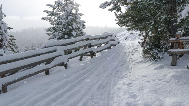
Tower Trails
Discover skiing and snowshoeing opportunities in the Tower area. 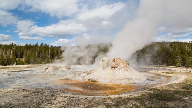
Places To Go
Discover the highlights of Yellowstone's vast 2.2 million acres, ten visitor centers, and eight developed areas. 
Plan Your Visit
Yellowstone changes with the seasons—make the most of your visit! Plan ahead to keep your trip safe, fun, and unforgettable. 
Accessibility
Discover Yellowstone's accessibility resources like the NPS Mobile App, Access Pass, and assistive services. |
Last updated: July 3, 2025