
Research Report
Recording a Mid-century Modern Landscape in Denver, Colorado
by Ann Komara
Flashback, April 2003
Demolition fences are soon to go up around Skyline Park, a 30-year old Lawrence Halprin design in the heart of downtown Denver, and a $10,000 Colorado State Historic Fund Emergency Grant just came through to record the site before it succumbs to the wrecking crew. Time is of the essence. Yet, the "principal investigator" for the documentation grant has 40 papers to grade, and the potential corps of landscape architecture volunteers is entering final juries and exams. Admittedly, this urban park is small—only 3.2 acres—but it is signature Halprin: an integrated sculptural design with many concrete walls; three unique fountains; and a series of built-in seats, lights, drinking fountains, and waste receptacles. What appears so unified actually contains a lot of variation and unique responses to achieve the three-block long, urban promenade.(Figure 1)
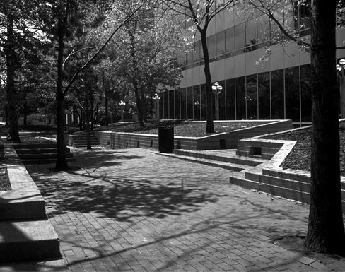 |
Figure 1. This general view looking west in Skyline Park's 3rd block, between 17th and 18th streets, shows details of the concrete walls and seats. (Courtesy of the author.) |
Documenting all of Skyline Park, including the board-formed, cast-in-place concrete detailed with reveal lines, battering pattern, and several surface finishes, looms as a daunting task. The project, moreover, is destined to be HALS No. CO-1, the first landscape survey for the National Park Service's Historic American Landscapes Survey program in the State of Colorado.(1) Guidelines for HALS exist but are in draft form and are largely untested for the nuances that distinguish landscapes from buildings and other structures.
Flash forward, February 2006
Three years later, Halprin's mid-century modern landscape has been replaced with a "living room" constructed with expensive materials but that remains unfinished.(2) The HALS documentation has only a few, final edits before heading to the Heritage Documentation Programs of the National Park Service (HABS/HAER/HALS) and then to the Library of Congress. To celebrate the recording project's completion—and to mark the passing of the original design—an exhibition of the Skyline Park HALS work is going up at the University of Colorado's College of Architecture and Planning. How was the HALS project done? What strategies, pitfalls, and successes figured into the HALS recording process? What distinguished this particular documentation project from others?
Drawing for HALS
Time and money shaped the parameters for the HALS documentation of Skyline Park. The initial emergency documentation grant was supplemented with support from the State Historic Fund, the National Park Service, and some private donors.(3) The unhappy coincidence between receipt of the initial funding with the academic schedule and the site's demolition created two immediate problems. First, despite the lure of pay, students were able to work for only limited periods of time. As a result, the field crew neared two dozen in number, and the few who had experience were rotated among the field teams. Second, the timing necessitated certain methodological practices aimed at efficiency.
The most decisive move was to use the full set of construction drawings produced by Halprin's office. The very large drawings were scanned and reproduced, and they formed the basis for the fieldwork. The teams measured vertically and horizontally against the drawings, noting alteration and differences. This approach saved time on the ground and facilitated the development of the Auto-CAD base plan and sections.
The resulting set of 11 drawings follows National Park Service standards. Students revised and then printed the CAD-based information and then rendered directly on Mylar sheets, splicing revisions when necessary, and producing archival-quality final drawings.(Figure 2) Yet, there were seemingly minor administrative factors that affected aspects of the drawing process. No HALS title block existed, so students had to develop one for approval by our local National Park Service liaison, Thomas Keohan, before setting any ink on the page. Moreover, the three-block length of the park required using the 34 x 44 inch mega sheets, which in turn dictated decisions about the scale of the drawings and the associated sections. The choice of a scale of 1 inch = 10 feet made it difficult to depict the variations in surface finishes and details but allowed for the spatial reading critical to understanding the park. In retrospect, perhaps the sections called for a layout counter to the traditional format: A "butterfly layout" set directly in relationship to the plan might have better shown the conditions unique to the shifts in elevation and differences longitudinally.
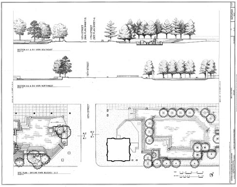 |
Figure 2. This ink-on-Mylar drawing by Sebastian Wielogorski is in a preliminary stage of production. (Courtesy of the author.) |
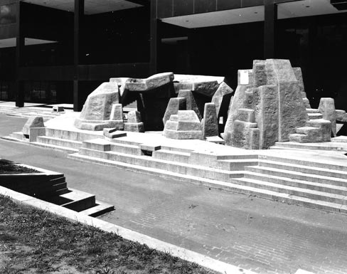
The sheets also include details and a unique component of analytical drawings reflecting how the park worked. The historical report and photographs complement the drawing set. The 75 large-format black-and-white photographs include some bird's-eye views from adjacent buildings that capture the park's spatial layout, planting, and circulation system. The photographs also provide sequenced views moving through the park and multiple shots of the three fountains.(Figure 3) Additional graphics are contained in numerous slides and field photos, both conventional film and digital, which will go to the Library of Congress as supporting documentation, along with the field measurements. These supplemental materials, referred to as "field notes," remain linked to the specific recording project for which they were produced.
 |
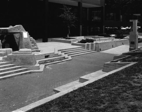 |
Figure 3. These HALS photographs by Gifford Ewing show the fountain in block one of Skyline Park. (Courtesy of the author.) |
At the onset of this project, the HALS guidelines were largely untested, and in some cases, undefined. Although similarities pervade HALS drawings and those produced for the Historic American Buildings Survey and the Historic American Engineering Record, and general conventions hold true for Skyline, some decisions were ad hoc. Plant materials, for example, need specific attention in all HALS projects. They posed a challenge in Skyline Park because the condition of the planting was the most degraded aspect of the site at the time of documentation. What are the best ways to reflect overgrowth, decline, and absence, or to distinguish and render the various species? For Skyline, how should the conditions in the field be shown, such as bare patches of dirt instead of grass, and trees that were either dead, cut to stumps, or in need of pruning?
Ultimately, the basic differences in tree species were rendered, but it proved difficult to draw the specific conditional qualities of each tree in situ. This situation was mitigated by a document placed into the field notes: A thorough spreadsheet of the trees (each numbered) recording species, caliper, height, and condition. The documentation also includes a video capturing the experiences of the landscape, conveying movement through space, the activation of the space with people and water, the play of light and shadow, and peripheral sound. These aspects were all critical to Halprin's design approach.
Two pitfalls are evident in the Skyline footage, however. First, like all the other fieldwork, the footage in the park was shot within a short time frame under conditions that were not ideal, and the team had little time to review, edit, or supplement what had been done. Second, because of current archiving practices at the Library of Congress, this documentary of the park and the preservation saga shown through interviews with key people involved must be submitted as part of the field notes.
The loss of Skyline Park should be a wake-up call for historic preservationists. Hindered by a lack of awareness of the project's vulnerability, the design and preservation communities failed to assay the quality of Skyline Park within its evolved urban context or articulate the park's position within Halprin's oeuvre and its exemplary reflection of the optimism and spirit of its era. In the face of this larger shortcoming, the recording of a significant work of mid-century landscape architecture for the young HALS program might be considered a small measure of success.
About the Author
Ann Komara is an assistant professor of landscape architecture at the University of Colorado at Denver/Health Sciences Center and the principal investigator and project coordinator for the documentation of Skyline Park. She can be reached at ann.komara@cudenver.edu.
Notes
1. This project was administered by Colorado Preservation, Inc., and the University of Colorado at Denver/Health Sciences Center [UCD/HSC] Department of Landscape Architecture. Field documentation, including video footage by Eric Altman and photography by Gifford Ewing, was completed two weeks prior to the start of demolition of the park in May 2003. The field team included the following University of Colorado students: Manish Chalana, Yi-Ping Fang, Kristen George, Arina Habich, Simone Howell, Erik Husman, Casey Martin, Carol McClanahan, Joey Noobanjong, Leanne Vielehr, Pearl Wang, Susan Whitacre, and Eugene Yehyen-Chun. Names of delineators, research assistants, and authors appear in the formal documentation.
2. The City and County of Denver hired the landscape architectural firm, Thomas Balsley Associates, of New York, to study the park and offer solutions for the redesign. The process included many public meetings, several design alternatives, and, finally, the resulting design, which has kept a few Halprin-era elements within the park, notably two of the original fountains. Balsley referred to the site as downtown Denver's "living room" in 2003.
3. The initial grant applications, written by Ann Mullins and submitted through Colorado Preservation, Inc., were for support from the Colorado State Historical Fund, a program of the Colorado Historical Society, Project #04-Mi-015. Funding and support were also provided by the City and County of Denver, the UCD/HSC Department of Landscape Architecture, the UCD/HSC Center for Preservation Research, the UCD/HSC Colorado Center for Community Development, and the National Park Service. Individuals contributing financial support included Tom Balsley, Ann Mullins, Jeremy B. Fletcher, and David Owen Tryba.