
Research Report
Historic Context and National Register Eligibility for Colorado Irrigation Ditches and Canals
by Michael Holleran and Manish Chalana
Landscape features related to irrigation have unique cultural significance in the American West. Like the Spanish colonial acequias, or irrigation ditches, that are preserved and interpreted as part of the San Antonio Missions National Historical Park in San Antonio, Texas, historic irrigation systems in communities throughout the West have potential as vital cultural resources. A recent project in Colorado has confirmed this to be the case in the Rocky Mountain State.
In Colorado, most of the land is semi-arid, and, like the rest of the interior West, its settlement depended upon irrigation. The first order of business for settlers was digging ditches to take mountain snowmelt from streams to fields on the dry sunny lowlands. The earliest "pioneer ditches" watered bottomlands next to streams through small, hand-dug channels. By the 1880s, professional engineers and armies of paid laborers built great canals up to 100 miles long, financed by out-of-state capital. Beginning early in the 20th century, the Bureau of Reclamation built comprehensive water development projects, frequently incorporating earlier ditches and canals into their distribution systems. Colorado was the nation's leading state in irrigated acreage from 1899 to 1919. The irrigation ditch in all of its forms is the characteristic landscape feature of settlement in the region.
As the West has urbanized and agriculture has modernized, how have these landscapes evolved, and what remains of them? These questions arise formally because our system of managing cultural landscapes—the National Register of Historic Places and cultural resources surveys—requires some means of evaluating both the significance of individual resources and the integrity of their surviving fabric. The multi-faceted irrigation ditch system, like other utilitarian landscapes, was not created and did not evolve in the same ways as the individual historic buildings around which these concepts were first formulated.
To address these issues, the Colorado Center for Preservation Research at the University of Colorado at Denver recently completed a historic context report for irrigation and water supply ditches and canals in Colorado, with support from the Colorado Historical Society's State Historical Fund.(1) This report includes a history of Colorado's water systems, a guide to research sources, and an illustrated taxonomy of the parts of ditch and canal systems and other property types that may be associated with them. It also addresses the challenge of applying National Register eligibility standards to these fluid landscapes.
Over nearly 40 years, more than 3,300 Colorado cultural resource surveys have recorded ditches or portions of ditch systems. These surveys offered a starting point, but closer examination revealed redundancies indicating that the number of unique ditches at least partly surveyed was closer to 1,000. Additional documentary research was necessary to understand what fraction of Colorado's historic irrigation resources this represented. The 1950 U.S. Census counted 9,258 "irrigation enterprises" running 17,000 miles of canal in the state.(2) This total includes main ditches but not the tens of thousands of miles of lateral ditches that distribute water from main ditches to the fields.(Figure 1)
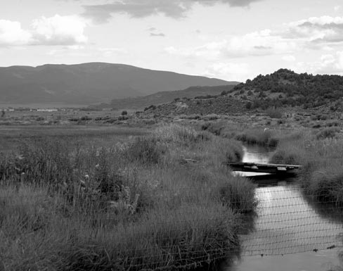 |
Figure 1. This 2004 view shows the 1852 San Luis People's Ditch. (Courtesy of the author.) |
More detailed information was available through the Colorado Department of Water Resources (DWR). The State Engineer's Office within DWR regulates and keeps records of every diversion from a natural stream. The DWR database does not include complete information about ditch lengths, but it does link to records on water rights, so sorting for the earliest water right linked to each ditch gave an excellent approximation of its date of construction. DWR data was also used to compile a statewide list of 22,800 ditches and canals, with about 17,500 of these constructed before 1950 (the increment above the census numbers reflects mainly smaller ditches, serving a single farm or ranch and thus falling below the census threshold for "enterprises"). The vast majority were constructed between 1870 and 1920, peaking in the 1880s.
Depending on which figure one takes as a total, only 4 to 10 percent of Colorado ditches had been surveyed. Fortunately, Colorado's water resource database also included locational data, which together with the dates of water rights, made a mapping of historical water development at a stream-by-stream level of detail possible.
National Register Significance Criteria
Many ditches meet National Register criteria for at least local significance.(3) The development of water resources is central to Colorado's history, and individual ditches and canals were essential to the development of particular communities and regions, meeting criterion A for association with events contributing to broad historical patterns. Such significance is not limited to the earliest pioneer ditches but may arise from later phases of historical development. In addition, ditches represent not only physical systems but also social institutions. In the Hispanic cultural region of New Mexico, Texas, and southern Colorado, the same word "acequia" denotes both the physical ditch and the community organization that manages it.(4) While many canal systems have always operated within the labor relationships of the commercial economy, others remain mutual ditch companies that have been cared for by their shareholders for generations.(Figure 2)
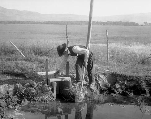 |
Figure 2. Photographed by Louis Charles McClure between 1908 and 1915, this view, entitled "Irrigation in Routt County," shows a simple wooden lateral turnout. (Courtesy of the Denver Public Library Western History Collection.) |
The other broadly applicable category of significance is criterion C, resources embodying the distinctive characteristics of a type, period, or method of construction, including individual features more appropriately considered together as a district. Such significance may arise from vernacular construction or from advanced engineering and may reside in individual components or in the arrangement of a whole system. Small ranch ditches, or laterals within larger systems, may not meet significance criteria on their own but are apt to be important contributing components in any larger site or district.
Significance under criterion D, the potential to yield information important in prehistory or history, is not limited to defunct ditches that exist only as potential archeological sites. Functioning ditch systems may yield information unavailable elsewhere. Ditch laterals, for example, whose location and arrangement were seldom contemporaneously documented, can provide information on the historical arrangement and use of agricultural lands. Remnant lateral turnout gates, where the laterals themselves have disappeared, may be the only evidence of previous development patterns.
Evaluating the Integrity of Working Landscapes
While a completed context study makes establishing significance for Colorado irrigation ditches and canals relatively straightforward, a significant property must also possess integrity to be eligible for the National Register, that is to say, it must have the ability to convey its significance through key identifying features. The National Register recognizes seven aspects of integrity—location, design, setting, materials, workmanship, feeling, and association—that are prioritized according to the reasons a property is significant and evaluated against comparable sites. The ditch context study concluded that a more holistic approach to assessing integrity through design and location, as well as an increased emphasis on feeling, may be the most effective way of assessing the integrity of these historic resources.
For working landscapes that continue in use, integrity can be a challenging question. A ditch that no longer functions may be more likely to retain intact original components such as wooden control gates. A working ditch wears out wooden structures, and even concrete ones, but continues the historic use of the resource. To encourage the preservation and recognition of working landscapes, the evaluation of integrity must accommodate the changes that are normal, or least necessary, for continuing operation.
Initial construction (at least until the Federal Government projects after the Newlands Act of 1902) was governed by expediency to get water running.(5) It was partly a matter of survival, but it was further reinforced in law. Water rights in Colorado were based on the date at which one began working to divert water and carried that work expeditiously through to completion. Speed was of the essence. Durability could wait for the second draft.
This technological evolution was evident on almost every ditch in the replacement of components, most often one piece at a time rather than wholesale along its entire length. The new component was usually something of familiar form in new materials, and almost always something of similar function on the same location. For example, ravine crossings were first bridged by open-channel hollow logs called canoas. Later variations on this same form were constructed of milled lumber and then semicircular sheet metal channels on wood frames. Thus the ditch as a system remained stable, functioning in the same way on the same alignment. Integrity of design was maintained if design was considered at the level of the whole system rather than individual components. The timing of replacement was not arbitrary, but most often took place after ditch components failed in floods or other crises.(6)
One recurring example was the diversion dams of river stones or brush that directed water toward the headgates of little pioneer ditches.(Figure 3) They washed out in the high waters of spring and were rebuilt as the waters fell. Ditch users who still reconstruct a diversion dam each year in this manner represent a survival of tradition, and that tradition is one of cyclical renewal. Such renewal may operate on cycles longer than a year. Many components, built of permanent-looking materials, are routinely replaced long before they are 50 years old in order to assure continued functioning of the system.
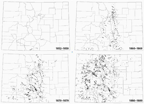 |
Figure 3. Early ditch headgates in Colorado have been mapped by decade. (Courtesy of the authors.) |
Over the long run, even ditch alignments may change in normal operations. Where ditches cross drainage channels, where they traverse unstable soils, or where their banks are colonized by muskrats, they can wash out. The channel traditionally was restored by digging it farther into the slope, moving the alignment uphill. Location, like design, should be evaluated for a whole ditch, rather than for every point along it. A ditch is not a collection of points or features but a whole, both functionally and as a presence in the landscape.
Operating ditches are also a resource type whose integrity may be reinforced by the elusive aspect of feeling. Flowing water in an arid environment is dramatic and evocative. The sight and sound of water, and our awareness that it is on its way to be useful, may help a ditch express its essential significance, and thus retain integrity in the face of other changes.
The Colorado Office of Archaeology and Historic Preservation used the ditches and canals context report as the basis for a multiple property nomination to the National Register. A clearer understanding of the variety of ditch and canal resources assisted in evaluating and listing them. Smaller-scale contexts for individual river valleys (as have been produced for the New Mexico State Historic Preservation Office) might provide more specific background for evaluating individual ditches. The experience of this project suggests that the State Engineer's water databases, analyzed through GIS, can be an effective tool in producing such contexts. A better understanding of the ways that these dynamic resources change in the course of ordinary operation will help in evaluating their integrity, and in maintaining them as working landscapes and a continuing part of the region's heritage.
About the Authors
Michael Holleran is the director of the Graduate Program in Historic Preservation at the University of Texas, Austin, and formerly the founding director of the Colorado Center for Preservation Research at the University of Colorado at Denver/ Health Sciences Center. Manish Chalana teaches in the Department of Urban Design and Planning, University of Washington at Seattle.
Notes
1. Michael Holleran, Historic Context for Irrigation and Water Supply Ditches and Canals in Colorado (Colorado Center for Preservation Research, University of Colorado at Denver/Health Sciences Center, 2005). The report can be downloaded at http://www.cudenver.edu/preservation.
2. See Charles A. Lory, "Foreward," in Colorado Water Conservation Board, and Colorado State University, A Hundred Years of Irrigation in Colorado; 100 Years of Organized and Continuous Irrigation, 1852-1952 (Fort Collins: Colorado Water Conservation Board and Colorado Agricultural and Mechanical College, 1952), 4.
3. National Register, History and Education, How to Apply the National Register Criteria for Evaluation (Washington, DC: National Park Service, Department of the Interior, 1997).
4. José A. Rivera, Acequia Culture: Water, Land & Community in the Southwest (Albuquerque: University of New Mexico Press, 1998); Stanley Crawford, Mayordomo: Chronicle of an Acequia in Northern New Mexico (Albuquerque: University of New Mexico Press, 1988).
5. Named for Rep. Francis G. Newlands of Nevada, the Newlands, or Reclamation, Act of 1902 set aside funds from the sale of public lands in 16 western states for the construction of irrigation projects intended to reclaim arid lands.
6. Early ditches retain few if any original components, as shown by a detailed survey of three ditches in Boulder, Colorado, dating from 1860, 1862, and 1888. In 25 aggregate miles, out of 358 recorded features, the only ones that date from original construction are some of those integral to the channel itself: one tunnel, several rock cuts, possibly some retaining walls. None of the others, with the possible exception of one cistern, dates from the 19th century. This data seems to indicate a remarkable bias against any first-generation survivals.