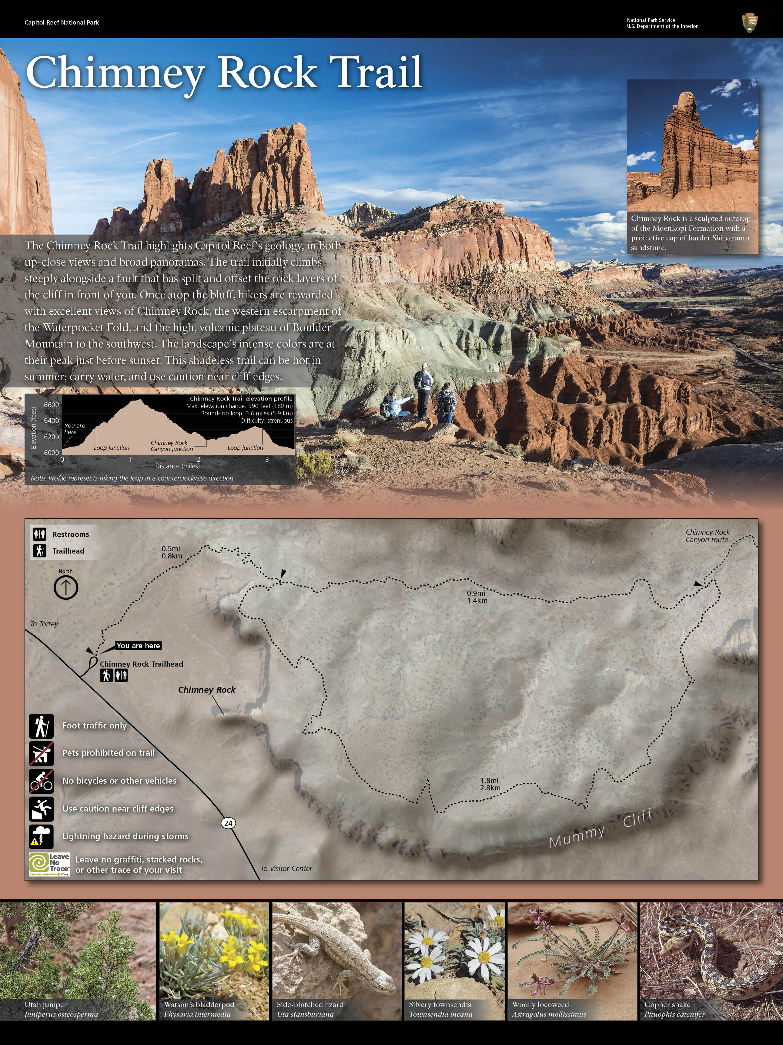
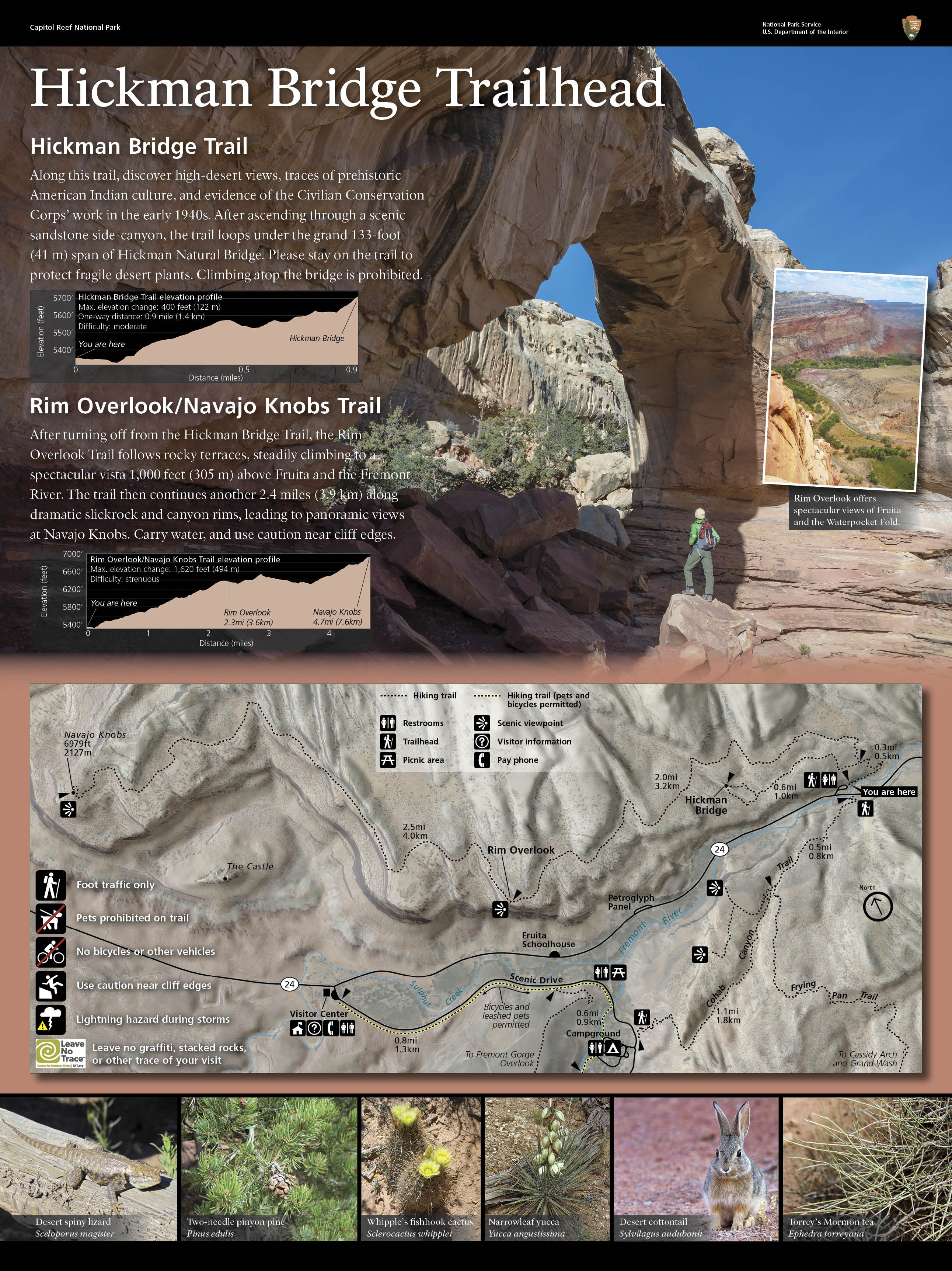
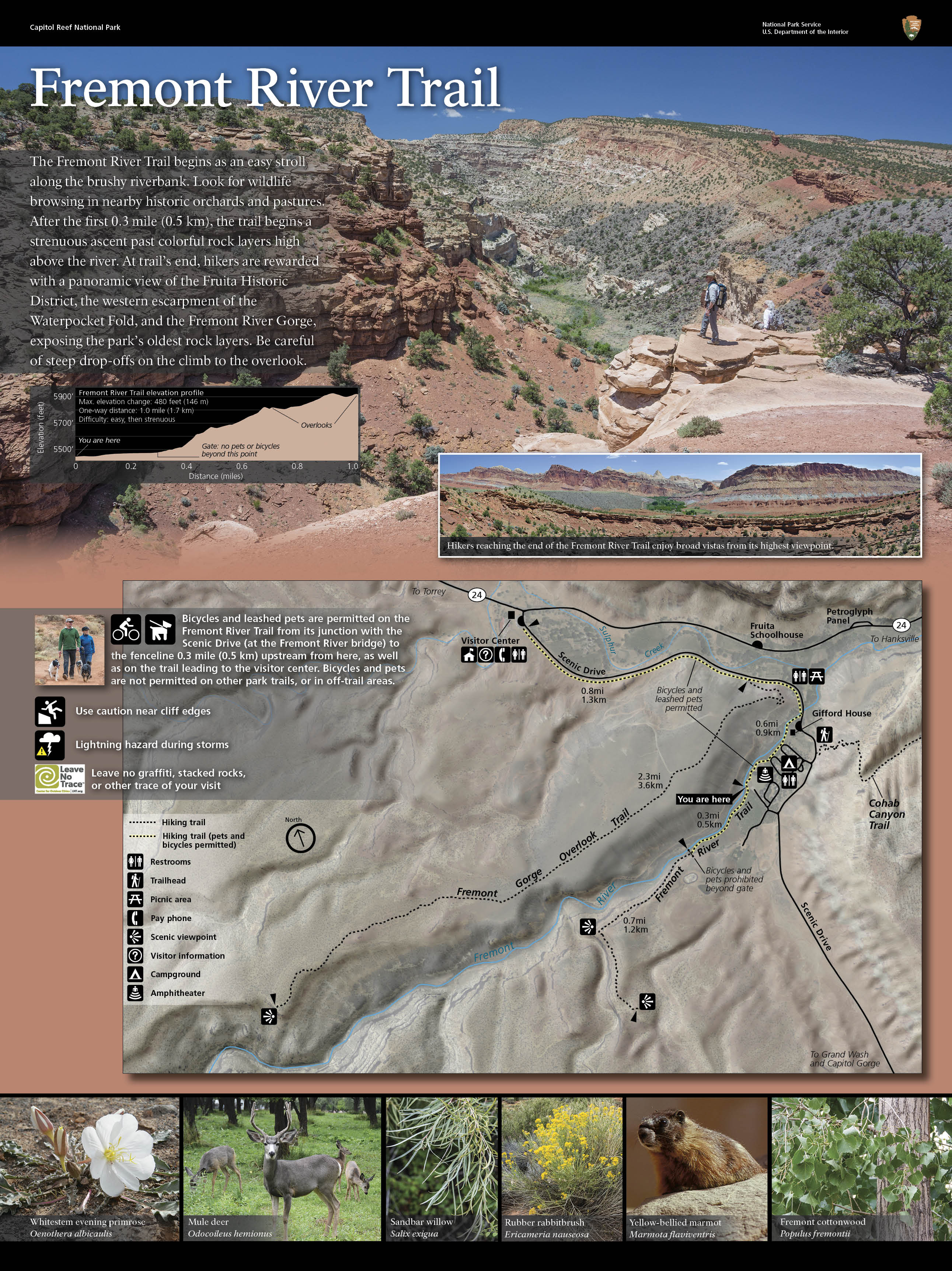
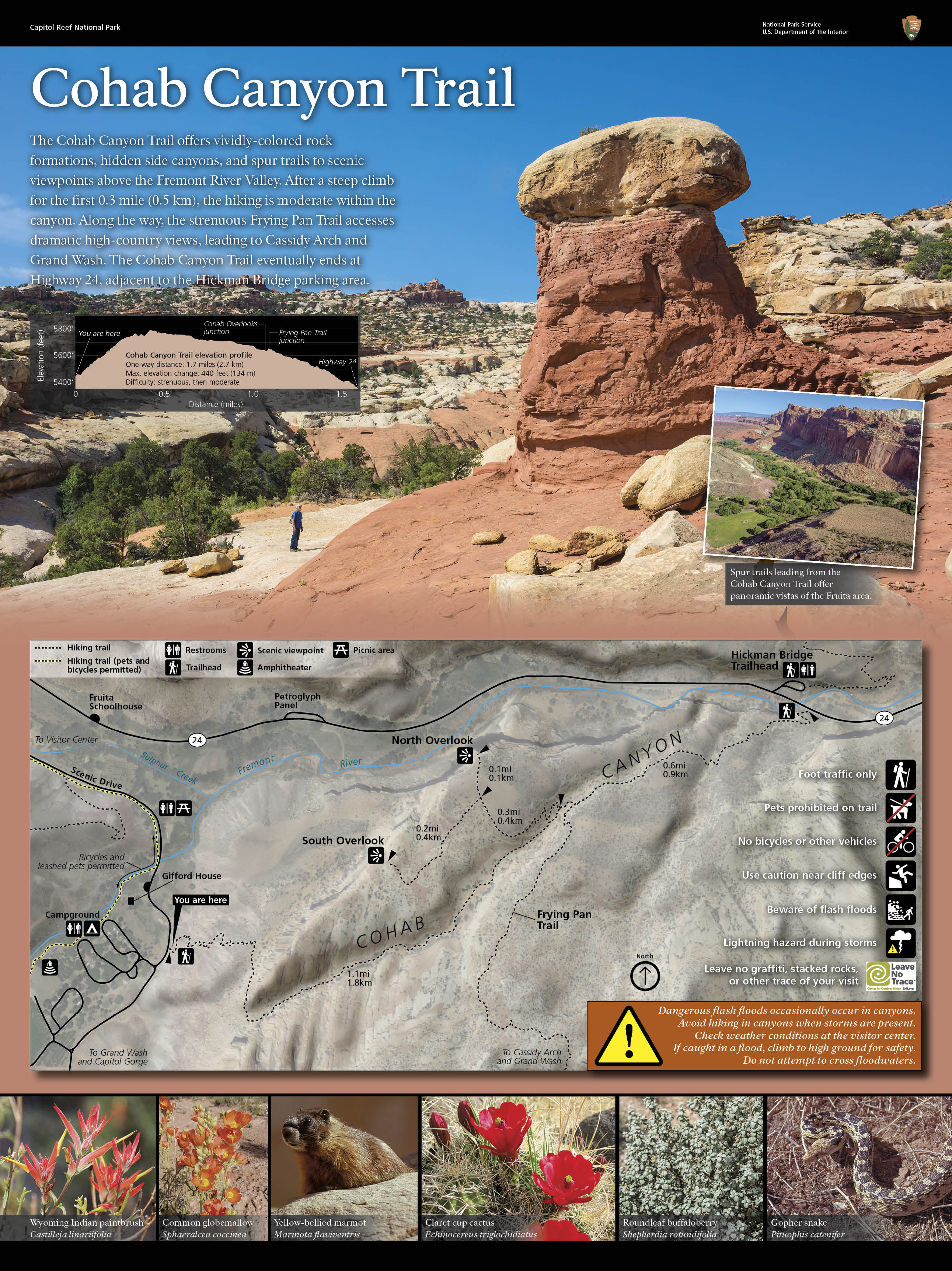
Trail Guide

Hickman Natural Bridge
The Hickman Bridge Trail goes under and around the natural bridge, and is considered moderate.

NPS

TRAIL DIFFICULTY RATINGS:

Easy: uneven ground, but fairly level.

Moderate: a mix of steep grades and level sections.

Strenuous: steep grades, uneven terrain and long, steady climbs.

Starting elevation for many trails in Capitol Reef is around 5,000 feet (1524 meters), which can make even "easy" trails challenging for people visiting from lower elevations.


Trail

One-Way Distance

Elevation Change

Difficulty

Description

Capitol Gorge 1.0 mi
(1.6 km)
80 ft
(24 m)
Easy Deep canyon, historic inscriptions, short climb to waterpockets ("tanks")
Goosenecks 0.1 mi
(0.2 km)
<50 ft
(<15 m)
Easy Dramatic canyon views
Grand Wash 2.2 mi
(3.6 km)
200 ft
(61 m)
Easy Deep canyon, narrows
Sunset Point 0.4 mi
(0.6 km)
<50 ft
(<15 m)
Easy Panorama, good for sunset
Cohab Canyon 1.7 mi
(2.7 km)
440 ft
(134 m)
Moderate Hidden canyons, views of Fruita, panoramas at spur trail view points
Fremont River 1.0 mi
(1.7 km)
480 ft
(146 m)
Moderate Easy stroll along river, then steep climb to panoramas
Hickman Bridge 0.9 mi
(1.4 km)
400 ft
(122 m)
Moderate 133-foot natural bridge, canyon views
Cassidy Arch 1.7 mi
(2.8 km)
670 ft
(204 m)
Strenuous Natural arch, slickrock, canyon views
Chimney Rock Loop
round trip
3.6 mi
(5.9 km)
590 ft
(180 m)
Strenuous Panoramas of Waterpocket Fold cliffs, good for sunset
Fremont Gorge Overlook 2.3 mi
(3.6 km)
1,090 ft
(332 m)
Strenuous Short climb to open mesa top, ends at high viewpoint on rim of gorge
Frying Pan 2.9 mi
(4.6 km)
810 ft
(247 m)
Strenuous Connects Cohab Canyon and Cassidy Arch trails, ridgetop panoramas
Golden Throne 2.0 mi
(3.2 km)
730 ft
(223 m)
Strenuous Views of Capitol Gorge and Golden Throne
Navajo Knobs 4.7 mi
(7.6 km)
1,620 ft
(494 m)
Strenuous Continuation of Rim Overlook Trail, 360-degree mountaintop panorama
Old Wagon Trail Loop round trip 3.8 mi
(6.1 km)
1,080 ft
(329 m)
Strenuous Pinyon-juniper forest, views of cliffs and Henry Mountains
Rim Overlook 2.3 mi
(3.6 km)
1,110 ft
(338 m)
Strenuous Panoramas of Fruita and Waterpocket Fold from atop dramatic cliff
 
 
Artists image of a rock cairn. You will find many hiking trails marked with rock cairns.  Locating cairns may be difficult at first; look for rock piles or stacks.  PLEASE DO NOT BUILD NEW CAIRNS!
You will find many hiking trails marked with rock cairns.  Locating cairns may be difficult at first; look for rock piles or stacks.  PLEASE DO NOT BUILD NEW CAIRNS!

Hiking Suggestions

  • Bring a map on the trail! Download the Fruita Map and Guide, or pick one up at the visitor center. Hiking route descriptions can be downloaded and printed off as well.
  • Plan for all types of weather. The summer sun is intense, and some trails rise to 6,900 feet (2,100 m) in elevation. ALWAYS CARRY WATER. The summer can also bring monsoon rains and dangerous flash floods.
  • For your own and other's safety, stay on established trails; do not shortcut switchbacks or throw rocks.
  • Check out these tips for hiking with kids!
  • Know where you can go with your pet.
  • Follow these tips to have a safe hike!
  • Camping is not permitted within sight or sound of any trail, road or developed area except at established campgrounds. Before taking overnight trips, contact a park ranger who can suggest backcountry camping areas. A permit is required for backcountry camping and can be obtained at the visitor center free of charge.
  • Possession, destruction, or removal of any animals, plants, rocks or artifacts is prohibited. Leave no trace of your visit.
  • Detailed trail descriptions, hiking guides, and maps are available from the Capitol Reef Natural History Association Bookstore.

Last updated: February 23, 2024

Park footer

Contact Info

Mailing Address:

HC 70, Box 15
Torrey, UT 84775

Phone:

435-425-3791
Recorded park information available 24 hours a day. Phones are answered when staff is available. If no one answers, please leave a message, your call will be returned. Questions may also be sent to care_information@nps.gov.

Contact Us