The Narrows from the Top Down

 
Hiking The Narrows
Slot canyons provide an experience unlike any other. However, preparation is needed for the cold water and difficult terrain.

NPS Photo

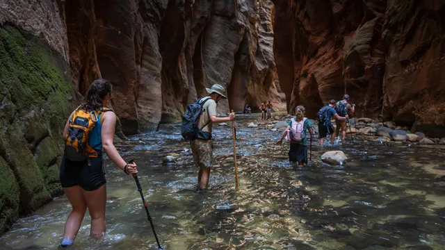
The Virgin River has carved a spectacular gorge in the upper reaches of Zion Canyon. 16 miles long, up to 1,000 feet deep, and at times only 30 feet wide, The Narrows makes for an unforgettable wilderness experience.

Here, you can wade in the crystal-clear waters of the Virgin River, bask in the beauty of hanging gardens, and walk in the shadows of soaring walls and sandstone grottos.

However, this is not a trip to be underestimated. When hiking down the Virgin River Narrows, at least 80% of the route is spent wading, walking, and swimming sections of the river. There is no maintained trail – the river is the route. The current is swift, the water is cold, and the rocks underfoot are slippery. Flash flooding and hypothermia are constant dangers.

Good planning, proper equipment, and sound judgment are essential for a safe and successful trip. Plan ahead and know what to expect before hiking into the Narrows. Visit our Narrows Safety page for recommendations and safety tips.

Details

  • Starting Location: Chamberlain’s Ranch
  • Ending Location: Temple of Sinawava (Shuttle Stop 9)
  • Pets: Not allowed
  • Distance: 16 mi (26 km) one way
  • Elevation: 1,300 ft (400 m)
  • Estimated Hiking Time: 10-14 hours
    • This time can be split over two days with an overnight backpacking permit.
  • Permits: Wilderness permits are required

Top-Down Permits

Hikers can complete the Virgin River Narrows as a single-day through-hike or as a two-day overnight backpacking trip. Both trips require a Wildness Permit. Visit our Virgin River Narrows Permits page for more information.

Overnight Backpacking Trips

If you plan to complete all 16 miles of the Virgin River Narrows as an overnight backpacking trip, you will need to obtain a Wilderness permit for your campsite.

This Wilderness permit will allow your group to start at Chamberlain's Ranch Trailhead, spend one night in a designated Narrows campsite, and then exit at the Temple of Sinawava the next day.

  • Overnight backpacking is only permitted in designated campsites. There are 12 campsites in the canyon, all of which are roughly halfway between Chamberlain’s Ranch and the Temple of Sinawava.
  • All overnight backpackers must begin their trip at Chamberlain’s Ranch and end at Temple of Sinawava. Upstream travel to campsites is not permitted.
  • You can view Narrows campsite photos on our website before booking.

Through-Hiking Timetable in Hours

This timetable is an approximation. The trip may be done in less time, but allowances have been made for breaks, pictures, and slower hiking. Track your progress by recognizing these side canyons and landmarks. Deep Creek, Kolob Creek, and Big Spring are easier to recognize, but the mouth of Goose Creek can be easy to miss.

If you plan to hike during the shuttle season, be sure to check the shuttle schedule. You do not want to miss the last shuttle out of the canyon!

Landmark Time to Reach
Chamberlain's Ranch 0:00
Bulloch's Cabin 1:00
First Narrows 3:30
Waterfall 4:15
Deep Creek 5:00
Kolob Creek 5:45
Goose Creek 6:35
Big Spring 7:20
Orderville Canyon 10:00
North End of Riverside Walk 11:50
Temple of Sinawava 12:20

Current Conditions

Water levels in the Virgin River Narrows range from ankle-deep to multiple feet above your head, even when the flow of the river is low. For most of the year, much of the river is ankle-to-knee-deep. However, all top-down hikers should be prepared for deep sections where swimming is required.

You can check the current flow rate on the USGS website. Learn about how the flow rate affects hiking here.

Closures & Flash Floods

Active closures are posted on our Current Conditions page. You can check current flash flood potential ratings on the NWS website.

All top-down trips into the Virgin River Narrows are closed when the flow rate of the Virgin River exceeds 120 CFS. Wilderness permits are not issued during closures. Always have a back-up plan prepared. The river often closes to hiking during spring snowmelt (April, May, and possibly later).

The river is also closed to hiking when the National Weather Service (NWS) issues Flash Flood Warnings, which are common during the desert monsoon season (July through September). The river will remain closed for at least 2 hours after a Flash Flood Warning is lifted.


Safety

Before your hike, always check the weather and flash flood potential. Flash floods can happen at any time, and your safety is your responsibility. Visit our Narrows Safety page for information about flash floods, cyanobacteria, and other potential hazards.

 
Rescuers with a patient
The Narrows is a strenuous trail that requires proper planning and equipment. Learn about flash floods, cyanobacteria, and more.
A tall and narrow canyon, only about 30 feet wide. Shallow water runs along the bottom.
The Narrows top-down is a strenuous 16-mile trek. This trip can be done in a single day or with one night of camping.

Last updated: September 18, 2026

Park footer

Contact Info

Mailing Address:

Zion National Park
1 Zion Park Blvd.

Springdale, UT 84767

Phone:

435-772-3256
If you have questions, please email zion_park_information@nps.gov. You can also listen to pre-recorded information by calling at any time. Rangers answer phone calls from 10 am to 5 pm Mountain Time, but a ranger may not answer if they are already speaking with someone else.

Contact Us