Last updated: October 10, 2024
Thing to Do
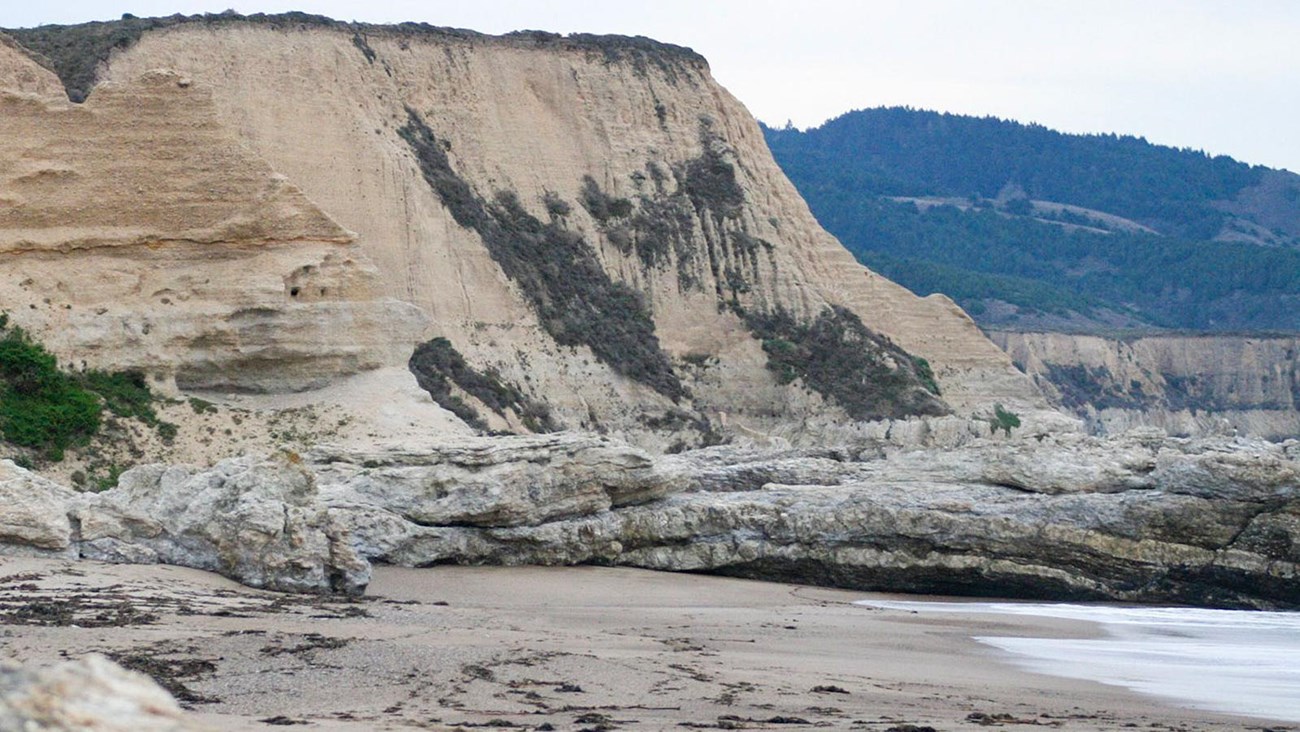
Hike to Sculptured Beach
NPS / A. Kopshever
Distances:
From the Limantour Beach parking lot: 5.4 miles (8.6 km) roundtrip, easy
From the Laguna Trailhead: 6.6 miles (10.6 km) roundtrip, easy/moderate
From the Coast Trailhead: 8.6 miles (13.8 km) roundtrip, easy
An easy to moderate walk through coastal scrub and grassland offers some breath-taking ocean views and leads to the rocky shoreline of Sculptured Beach, where one can look for intertidal organisms when the tide is very low. Visit our tidepooling for more information and please follow Leave No Trace's Tips for Tide Pooling. Consult a tide chart and local weather forecasts before setting out on your trip; venturing on to Sculptured Beach during hazardous surf conditions or a high tide can result in becoming trapped against the coastal bluffs. Visit the park's Beach Safety page for more information.
Some of this area was burned in 2020, when lightning strikes in the Woodward Valley started what became the 2020 Woodward Fire. There are vault toilets and potable water available at Coast Campground.
Sculptured Beach and the Laguna Trail, the Fire Lane Trail, and the Coast Trail southeast of Coast Campground are within the Phillip Burton Wilderness. Please practice Leave No Trace principles.
The routes described below pass through or by Coast Campground, where you can refill your water bottle at one of the campgrounds water faucets, or use the vault toilets.
Closest Trailheads to Sculptured Beach
- Limantour Beach. There are two parking lots at Limantour Beach:
- The main parking lot is located on the right as one descends Limantour Road toward the beach. It has a gravel surface and has space for a couple hundred vehicles.
- A small paved parking lot is located at the end of a spur road that leads east from Limantour Road just before one reaches the main lot. This parking lot only has 16 parking spaces. If you arrive early enough to park in one of these spaces (or are lucky to find a space later in the day), the hike to and from Sculptured Beach will be ~0.8 km (1.3 km) shorter roundtrip.
- Laguna Trailhead
- Coast Trailhead
Directions to Sculptured Beach
There are dozens of hiking routes that lead to Sculptured Beach. Even from the three closest trailheads (routes from which are described below), there are six or more different combinations of hiking on trails or walking on the beach that will get one to and from Sculptured Beach. This is due to how the Coast Trail runs parallel to the beach with three locations at which one can descend from the trail to the beach.
Please note: Storms in early 2023 caused significant damage to the Sculptured Beach Trail and the route is no longer a trail that the park will recognize or maintain. Please refrain from using it.
Beach Access Trails that connect with the Coast Trail
- Coast Trail's Limantour Beach Access Trail: This short connector trail is ~0.6 miles (0.9 km) from the small paved lot or ~1 mile (1.6 km) from the main parking lot at Limantour Beach. Or, if hiking from the Coast Trailhead, follow the Coast Trail for 1.9 miles (3 km). Or, if coming from Coast Campground, follow the Coast Trail west for 1.1 miles (1.8 km) or walk west on the beach for 0.8 miles (1.3 km). Look for a lone large pine tree growing on the edge of a low bluff. Just west of the tree is a 100-foot-long (30-meter-long) sandy path leading from the beach to Coast Trail.
- Coast Campground's Santa Maria Beach Access Trail: The second location to connect between the beach and the Coast Trail is at the Coast Campground. From the Coast Trail, a 600-foot-long (180-meter-long) dirt path branches off of the Coast Trail to the north of site 8, passing to the left of some hitching rails and, further along the path, to the right of a lone eucalyptus tree. This path descend along the east side of a creek that flows down to Santa Maria Beach. From the beach, this path isn't as obvious, especially if one is walking along the water's edge. Pay attention to the height of the bluffs. To the west of this beach access, the bluffs are significantly lower than to the east. The creek can also serve as a landmark. During drier periods, the creek's water may not stay above the surface of the beach all the way to the bay, but during the winter and spring, water from the creek will frequently flow over the sand to the bay, forcing one to get at least the soles of their shoes wet as they cross the creek. Coming from the west, it will be the first significant creek that flows onto the beach east of Limantour Beach's parking lots. Coming from the west, the Santa Maria Beach Access Trail is ~1.4 miles (2.2 km) from Limantour Beach's small parking lot and ~1.8 miles (2.9 km) from the main lot, and 0.8 miles (1.3 km) from the Coast Trail's Limantour Beach Access Trail. Coming from the east (e.g., from Sculptured Beach), it will be the second creek one crosses after leaving Sculptured Beach, which is 0.8 miles (1.3 km) away.
Directions from the Limantour Beach parking lots
Follow the path from either parking lot at Limantour Beach to the beach and head southeast on the beach for 2.1 miles (3.4 km) if you started from the smaller paved parking lot or 2.4 miles (3.8 km) if you started from the main parking lot. So long as the tide is low enough, you should be able to walk along the water's edge all the way to Sculptured Beach.
Directions from the Laguna Trailhead
This route steadily ascends the 0.8-mile-long (1.3-kilometer-long) southern leg of the Laguna Trail to a 400-foot-high (120-meter-high) ridge crest from which Drakes Bay is visible. The route then descends via the 1-mile-long (1.6-kilometer-long) southern leg of the Fire Lane Trail to the Coast Trail just north of the Coast Campground. Turn left on the Coast Trail for 0.1 miles (160 m) to reach the Coast Campground and it's Santa Maria Beach Access Trail. Descend to the beach and walk along the water's edge for 0.8 miles (1.3 km) to get to Sculptured Beach. (This route is dependent upon the tide being low enough for safe passage along the base of the bluffs.) Return along the beach to the Coast Campground, where you can either return to the Laguna Trailhead via the Fire Lane and Laguna trails. Or follow the Coast Trail to the Coast Trailhead, which is located across the Laguna Road from Limantour Lodge. Turn right on to Laguna Road and walk a short distance along the road to return to your vehicle.
Directions from the Coast Trailhead
Follow the Coast Trail for 2.8 miles (4.5 km) alongside a stream and then through bluff-top coastal grasslands to the Coast Campground. (As described above, one may descend to the beach after hiking 1.9 miles [3.1 km], if one so desires.) To return to the Coast Trailhead, retrace your steps. Alternatively, as described above, there are a number of other options, including returning via the Fire Lane and Laguna Trails to make your hike more of a loop hike. To do so, turn right onto the Fire Lane Trail 0.1 mile (0.2 km) west of the Coast Campground and follow the Fire Lane Trail and then the Laguna Trail 1.8 miles (2.9 km) back to the Laguna Trailhead. Walk through the Laguna Trailhead parking area to Laguna Road, turn left, and follow the road back to your vehicle at the Coast Trailhead.
The Coast Trail is a family-friendly, multi-use trail on which bicycles are allowed as far as Coast Campground. There is a bike rack bollard to which one may lock their bicycles near the Santa Maria Beach Access Trail junction. Visit the park's Bicycle Riding page for more information.
Be Prepared
This route description alone is not a substitute for a trail map. Print out the Point Reyes National Seashore's South District trail map (3,422 KB PDF) before your visit, or pick one up at the Bear Valley Visitor Center on your way.
Always check current conditions before heading out into the park and familiarize yourself with park regulations. Please practice Leave No Trace principles.
Visit the park's Hiking at Point Reyes National Seashore page for hiking tips and information about trail etiquette and safety.
Visit the park's Trail Advisories and Closures page for current information about closed trails, trails blocked by trees, or other temporary hazards or advisories.
Details
Duration
3-5 Hours
Allow three to four hours to hike the roundtrip distance to Sculptured Beach. Allow for more time to relax or tidepool at Sculptured Beach.
Activity
Hiking
Age(s)
All ages.
Pets Allowed
No
Pets are prohibited at Sculptured Beach and on the Laguna, Fire Lane, and Coast Trails, as well as other trails in this area. Visit the park's Pets page to learn more about where pets are welcome at Point Reyes National Seashore.
Activity Fee
No
Entrance fees may apply, see Fees & Passes information.
Location
Park at the Limantour Beach parking lot, or at the Laguna Trailhead or the Coast Trailhead along Laguna Road, Point Reyes National Seashore
Sculptured Beach is within the Phillip Burton Wilderness, located two miles southeast of Limantour Beach, which is the closest place to park. Alternatively, one could park at the Laguna Trailhead or the Coast Trailhead along Laguna Road. Allow 15 minutes drive time from Bear Valley to the Coast and Laguna Trailheads and 20 minutes to Limantour Beach.
Directions to Bear Valley
Directions from Bear Valley to the Coast and Laguna Trailheads
Directions from Bear Valley to Limantour Beach
Reservations
No
Season
Year Round
Winter
The heaviest rainfall occurs in the winter months. Come prepared for rain and drizzle to possibly last for several days. In between winter rains, it is often sunny, calm, and cool.
Spring
Most spring days are windy and this area frequently experiences fresh to strong breezes. Expect cool temperatures in March. By late May and early June, temperatures can be quite pleasant, even warm.
Summer
Although there is very little rain during summer months, there is often dense fog throughout the day in July, August and September with temperatures often 20 degrees cooler than at Bear Valley.
Fall
The coastal areas of Point Reyes experience some of the clearest days in late September, October and early November. The occasional storm will start rolling through in late October, bringing clouds, wind, and rain. The strongest winds occur in November and December during occasional southerly gales.
Time of Day
Day, Dawn, Dusk
Point Reyes National Seashore is open for day-hiking from 6 am to midnight. Camping and overnight parking is only permitted with a valid camping permit.
Accessibility Information
From Limantour Beach
At Limantour Beach, a flat, wide paved beach access path leads south from the accessible parking spaces for 270 feet (82 meters) to a wide footbridge with a wooden surface. Beyond the footbridge to the beach, the trail is covered in sand, progressively getting deeper the closer one gets to the beach. Limantour Beach itself is composed of loose sand, which may be firmer below the high tide line. As one gets closer to Sculptured Beach, the slope of the sand below the high tide line tends to get steeper. And a short distance east of the path leading to Coast Campground, the beach starts transitioning from all sand to rock outcrops, making passage in a beach wheelchair more challenging to impossible. There are two designated accessible parking spaces at Limantour Beach. There are six vault toilets adjacent to the accessible parking spaces, which in and of themselves were designed to be accessible, but the surface between the parking spaces and the vault toilets is unpaved soil that gets muddy when wet, and, therefore, is not smooth.
From the Coast Trailhead
The Coast Trail from the Coast Trailhead doubles as an eight-foot-wide (2.4-meter-wide) service/fire road that is composed of compacted dirt and gravel (and potholes and washboarding). Otherwise, the Coast Trail's northern 2.8 miles (4.5 km) is relative flat; the steepest section is at the Coast Trail's junction with the Laguna Road where the trail drops relatively steeply from the built-up road to the valley floor. The vault toilets at Coast Campground do not meet accessibility standards.
From the Laguna Trailhead
The Laguna and Fire Lane Trails are fairly narrow and moderately steep and can be deeply rutted in some places.
Tags:
point reyes national seashore,
point reyes,
phillip burton wilderness,
hiking,
sculptured beach,
beach,
tidepooling,
tidepools,
laguna trailhead,
laguna trail,
coast trailhead,
coast trail,
coast camp,
coast campground,
limantour beach,
santa maria beach,
coastal trail,
one to three hour hike,
over three hour hike