An official website of the United States government
Here's how you know
Official websites use .gov A
.gov website belongs to an official government
organization in the United States.
Secure .gov websites use HTTPS A
lock (
) or https:// means you've safely connected to
the .gov website. Share sensitive information only on official,
secure websites.
Please join Point Reyes National Seashore staff for Science Lectures, 45 minute presentations on scientific research being performed at Point Reyes and elsewhere in the California. Science Lectures are sponsored by the Pacific Coast Science and Learning Center at Point Reyes National Seashore. They usually occur at noon on many Thursdays throughout the year and are normally held at the Red Barn Classroom at Point Reyes National Seashore's Headquarters. All are welcome and admission is free.
Visit our Science Lectures page to learn about upcoming lectures.
Some of our Brown Bag Lectures in 2012 included:
Date: Thursday, March 22, 2012 Title: "Sonoma spineflower: the natural history and future survival of one of Marin's rarest plants" Presenter: Amelia Ryan, Wetland Ecologist, Point Reyes National Seashore Summary: The Federally Endangered Chorizanthe valida (Sonoma spineflower) currently has only one wild population, located within Point Reyes National Seashore, making it one of the rarest plants in Marin County and in California in general. Though commonly called Sonoma spineflower, the Point Reyes Peninsula is the only location where a population of this species has been documented. The talk covered the historic distribution of Sonoma spineflower, the factors contributing to its current restriction to one location, and touched on other aspects of its natural history. It also covered current efforts by the Park Service to provide for the ongoing survival of this species. In particular, it focused on a project undertaken in 2010-2011 (funded by a U.S. Fish and Wildlife Service Preventing Extinction Grant) that included new introductions of this species.
Sediment profile image of a mud crab in a burrow captured by Wormcam. Scale bars on border are 1 cm.
Date: Thursday, April 19, 2012 Title: "Bioturbation in a declining oxygen environment, in situ observations from Wormcam." Presenter: Kersey Sturdivant, Ph.D., Marine Ecologist, Cordell Bank National Marine Sanctuary Summary: "WormCam" is an underwater camera developed at the Virginia Institute of Marine Science with funding from the National Science Foundation. Still images and time-lapse movies from Wormcam help scientists better understand the important role that burrowing animals play in mixing seafloor sediments, and the physical forces that control erosion, deposition, and transport of seafloor sediments, nutrients, and contaminants. In this study, we developed a benthic observing system (WormCam) consisting of a buoy, telemetering electronics, sediment profile camera, and water quality datasonde, and deployed it in an area known to experience seasonal hypoxia. WormCam was deployed from early spring to late fall and images and water quality (WQ) data were captured every half-hour over the 5 month observation period. The images and WQ data were used to quantify the impact of hypoxia on bioturbation, and observe infaunal behavior in situ. During the hypoxic observation period, by enhancing the images, we observed the dynamic nature of bacterial mat formation and infaunal response to this event.
Date: Thursday, May 3, 2012 Title: "Mechanical Removal of Invasive Beachgrass on Coastal Dunes: Creating Endangered Species Habitat at Point Reyes National Seashore" Presenter: Sarah Minnick, Point Reyes National Seashore Summary: Point Reyes National Seashore preserves some of the last remaining high quality coastal dune habitat in the United States. These dune systems are home to threatened and endangered plants and animals, such as Tidestrom's lupine, Western snowy plover, and Myrtle's silverspot butterfly. However, this habitat is seriously threatened by the rapid encroachment of two invasive, nonnative plant species, European beachgrass and iceplant. The Abbotts Lagoon Coastal Dune Restoration Project is restoring natural coastal dune processes and functions by removing invasive species south of Abbotts Lagoon. The public was invited to learn about the successful mechanical removal of 80 acres of beachgrass during the first phase of the project, see the initial monitoring results, and find out what's in store for the future.
Date: Tuesday, May 22, 2012 Title: "White House Pool: An Historical view" Presenter: Meg Linden, Volunteer with the Jack Mason Museum of West Marin History and a retired librarian Summary: Meg Linden presented an illustrated talk on the history of White House Pool and some of the adjacent areas. It included some history of the Piedmont Dairy (Shafter property) and Alderbrook Dairy (Garcia-Alcantara property).
Date: Thursday, May 24, 2012 Title: "Removal of Scotch Broom from Point Reyes National Seashore" Presenter: Lisa Michl and Ellen Hamingson, Point Reyes National Seashore Summary: Point Reyes National Seashore has been working on a daunting five-year project: to remove Scotch broom (Cytisus scoparius) from the Seashore. This invasive plant has been in the park for over 35 years and threatens native habitats, including several rare plants and threatened and endangered wildlife. The species also changes soil chemistry, which alters plants that can grow nearby. By removing this plant, we open up room for native species to repopulate. Scotch broom covers over 270 acres spread across 2,500 acres of the park. The main area is bound by the Estero and located south of Pierce Point Road, west of Mt. Vision Road, and north of Limantour Road. Most of the area is covered in scattered patches, but in the center is the core area, where a thick stand of seven-foot-tall Scotch broom looms. A team of park staff, volunteers, interns, and contractors have been tirelessly working since 2010 to remove this tough plant. As of January 2012, over 164,454 plants have been treated over approximately 200 acres. A variety of tools are used to remove plants. Each mature plant that is removed eliminates over 10,000 seeds from the seed bank. This talk covered: reasons for prioritizing Scotch broom for current management; a description of the work done in FY2010-12; and a preliminary analysis of data from monitoring plots within the project area.
Date: Tuesday, June 19, 2012 Title: "LiDAR and the Tomales Bay Watershed - New high-resolution GIS information available for our watershed" Presenters: Dr. Ellen Hines, SFSU Marine & Coastal Conservation and Spatial Planning Lab Summary: The public was invited to attend a special presentation during the Tomales Bay Watershed Council Meeting at the Dance Palace in Point Reyes Station. Tuesday, June 19, 2012, from 3:30 pm to 4:30 pm. All were welcome and admission was free.
Four photos that depict an increase in shrub abundance over time at a site from which cows were excluded on Bolinas Ridge.
Date: Thursday, June 21, 2012 Title: "20 Years of Rangeland Vegetation Monitoring at Point Reyes National Seashore" Presenters: Robert Steers and Heather Spaulding from the National Park Service's San Francisco Bay Area Network's Inventory and Monitoring Program, and Dylan Voeller, John DiGregoria, and Devii Rao from of Point Reyes National Seashore Summary: In 1988, permanent vegetation monitoring plots were established on 51 rangeland sites located throughout Point Reyes National Seashore and the North District of Golden Gate National Recreation Area to assess vegetation status and trends. Vegetation sampling has shown that exotic annual grass species are vastly more abundant on the rangelands than any other exotic or native plant life forms, e.g., annual forbs, perennial grasses, etc. Also, the type of grazing operation (e.g., beef, dairy, grazing excluded) has a large influence on plant species composition. Over the last twenty years of monitoring, little change has occurred over all grazed sites taken collectively. However, when looking at changes over time for specific sites that are grouped by grazing operation or environment (e.g., cool outer coast, warmer Bolinas Ridge, etc.) some sites have seen changes, such as increased velvet grass (Holcus lanatus) in the most coastal influenced sites, decreased clover (Trifolium spp.) at sites recently (< 10 years) taken out of grazing, but increased coyote brush (Baccharis pilularis) in sites relatively long-removed (> 20 years) from grazing. Additional species-specific changes were also presented during this presentation, especially in regard to rangeland weeds.
Date: Thursday, July 26, 2012 Title: "Developing an Operation and Maintenance Program for Ikona Wildlife Management Area - Serengeti, Tanzania" Presenters: Jeffrey Jewhurst from Point Reyes National Seashore Summary: Point Reyes National Seashore's Roads Supervisor Jeffrey Jewhurst discussed the challenges of developing an Operations and Maintenance Program for a new USAID-built Visitor Center Complex in Ikona Wildlife Management Area (WMA), Tanzania. Ikona WMA serves as an extended ecosystem corridor adjacent to the 7,500 square mile Serengeti National Park. This talk recounted three intensive weeks of work by our Department of Interior Team.
Date: Thursday, August 9, 2012 Title: "Recovery of Africa's Largest Carnivore, Panthera leo, in the Greater Gorongosa Ecosystem of Central Mozambique" Presenter: Paola Bouley, Founder and Director of the Gorongosa Lion Project Summary: African lions in the wild have vanished from over 80% of their range and declined by 30% over the past two decades requiring urgent efforts to protect habitat and viable populations while embarking on recovery efforts where possible. The Greater Gorongosa Ecosystem in Central Mozambique, comprising Gorongosa National Park and surrounding buffer areas, is a 10,000 sq. km area of high biological diversity that once supported renowned herds of herbivores and a lion population estimated at over 500. Unfortunately, during Mozambique's civil war (1977-1992) Gorongosa's wildlife, including carnivores, were decimated.
The end of the war and a long-term conservation partnership between the Carr Foundation and the government (2006) has ushered in a new era of hope and wildlife recovery for Gorongosa. In just a decade significant increases in large-herbivore populations have ensued allowing the opportunity for recovery of top carnivores such as lion, leopards, hyena and possibly even wild dogs.
In 2012, the Gorongosa Lion Project was launched, an effort committed to the long-term recovery and conservation of lions in Gorongosa through Applied Research, Education & Capacity-Building and strategic Partnerships. Paola Bouley (founder and Director of the Gorongosa Lion Project) highlighted restoration efforts, successes, and challenges underway in Gorongosa with a focus on large carnivores.
Date: Tuesday, September 4, 2012 Title: "Point Reyes - A Photographer's View" Presenter: Dan Wells, Lecturer in Environmental Studies at the University of Vermont and Volunteer Photographer at Point Reyes National Seashore. Summary: Dan Wells wandered the Seashore with a camera throughout the summer of 2012. He shared his images and experiences. Visit his blog This Tardiest Explorer to view some of his photographs.
Date: Thursday, September 13, 2012 Title: "Long-term individual identification and site fidelity of white sharks off California" Presenter: Scot Anderson Summary: Scot discussed his recent publication in the journal Marine Biology.
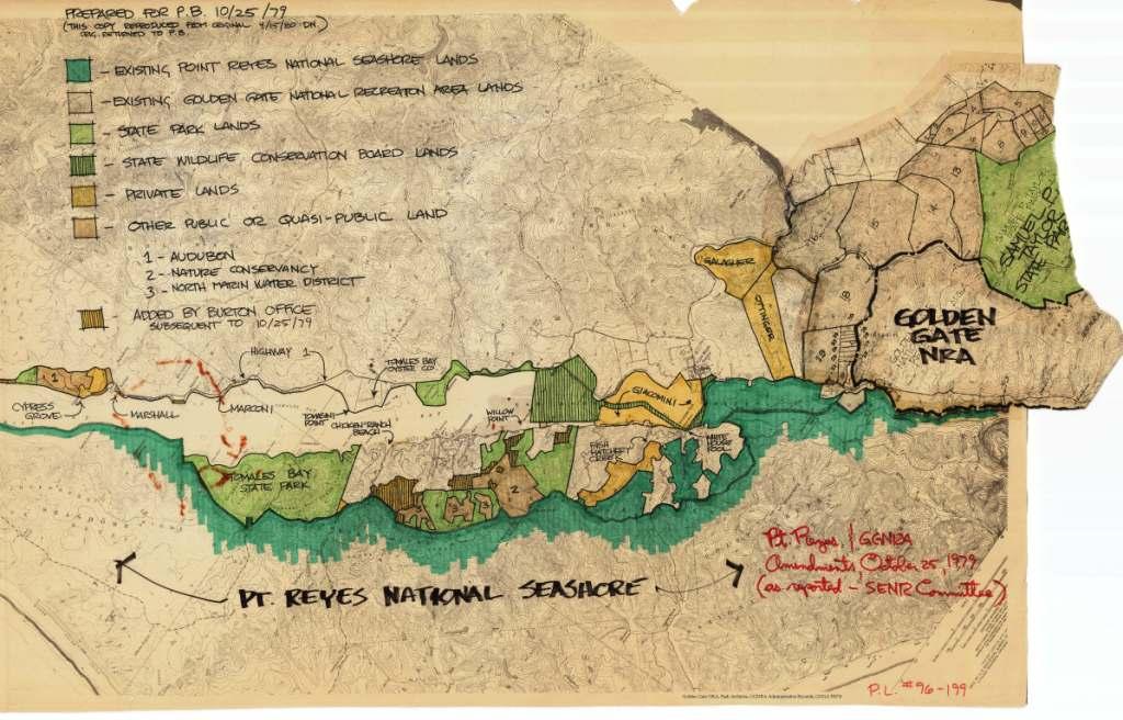
Lost map showing Point Reyes National Seashore and Golden Gate National Recreation Area boundary expansions near Tomales Bay which Congress approved in 1980.
Date: Thursday, December 6, 2012 Title: "The Mysteries of the Missing Map" Presenter: George Clyde of Marshall, California Summary: Local journalist George Clyde, who authored "How Rep. Philip Burton and a Magic Marker Hijacked Tomales Bay" in the current West Marin Review, recounted his discovery of the only known copy of the lost map that Congress approved in 1980 to expand the boundaries of Point Reyes National Seashore and Golden Gate National Recreation Area near Tomales Bay. The historic maps, drawn with Magic Markers, had their first public display at his talk. Clyde presented his findings and discuss the implications for the Parks today.
For more information about the Brown Bag Lectures, contact Ben Becker at 415-464-5187 by email.
415-464-5100
This number will initially be answered by an automated attendant, from which one can opt to access a name directory, listen to recorded information about the park (e.g., directions to the park; visitor center hours of operation; fire danger information; wildlife updates; ranger-led programs; seasonal events; etc.), or speak with a ranger. Please note that if you are calling between 4:30 pm and 10 am, park staff may not be available to answer your call.