Hiking

The Great Sand Dunes, and most of the forests, lakes and peaks of Great Sand Dunes National Preserve, are designated wilderness. These areas can be explored by day hikes or overnight backpacking trips.

 
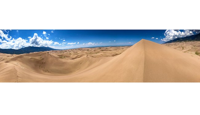
Panoramic View of Dunefield and Sangre de Cristo Mountains
View of the 30-square-mile dunefield and Sangre de Cristo Mountains from the highest dune on the first ridge.

NPS Photo

Dunes Exploration

No Trails
Explore any part of the 30 square mile dunefield you wish; there are no trails in the sand.

Footwear
High-top boots with long pants work best to keep sand out of your shoes. Do not wear sandals, which will just chafe your feet. In summer, bring closed-toe boots or shoes to prevent burning your feet.

Summer Safety
Summer air temperatures are pleasant at this high elevation, but during afternoon hours the sand surface can reach 150F degrees, and dangerous thunderstorms can develop. Plan to hike the dunes in early morning or evening to avoid heat exhaustion, burned feet, or fatal lightning strikes.

Wheelchair Access
A dunes-accessible wheelchair is available for free loan at the Visitor Center.


Colorado's Natural Beach
When there's water in Medano Creek at the base of the dunes, adults and kids alike love to splash in the stream. Watch for waves in the water, a phenomenon called "surge flow." As mounds of sand form and fall in the creek bed, water surges, similar to the action of waves at a beach. Watch a video, get detailed tips for enjoying the creek, and find current conditions and forecast flow on the Medano Creek page.

 
Green grasses, trees, and Massive Dune
The high dune on the first ridge is the most common destination for hikers.

NPS/Scott Hansen

High Dune on First Ridge

The high dune on the first ridge is neither the highest in elevation nor the tallest in the park, but it looks that way from the main parking lot. This is the most common destination in the dunefield, providing a great view of the entire dunefield. It is about 693 feet (211 m) from base to top. Cross a half-mile (1km) of the Medano Creek bed, then zigzag up along ridgelines to reach it. There are no trails in the dunefield.
GPS coordinates for High Dune on First Ridge as of 2021:
37.74908, -105.532775

Average round trip hiking time for High Dune is 2 hours and 2.5 miles (4 km). Popular hiking applications are often inaccurate or misleading. Plan to take as much as 4 hours to hike roundtrip, if not acclimated to the higher altitude and lower oxygen level.

 
A panoramic view of a dunefield with mountains in the background
The summit of Hidden Dune is at right, rising above the dunefield. Most hikers will go over the slightly lower false summit at left before reaching the actual summit 1/4 mile (0.4 km) farther to the north.

NPS/Patrick Myers

Hidden Dune

As of 2021, Hidden Dune is tied with Star Dune as the two tallest dunes in North America at 741 feet (225 m).

Hidden Dune is named for its remote location in the dunefield, where it is not visible from most of the main visitor day use areas. It is even hidden from much of the high first ridge of dunes. A false summit (at left in photo) hides the actual summit for much of the hike to Hidden Dune.

GPS coordinates for Hidden Dune summit as of 2021:
37.775916, -105.531912

Plan on 7 miles (11 km) round trip over 6 hours, starting from the main Dunes Parking Lot. Hike north/northwest to reach it. In summer months, plan your hike to begin in early morning to avoid extreme sand heat or thunderstorms with lightning. With high-clearance 4WD, you may also begin your hike at Sand Pit or Castle Creek Picnic Areas on the eastern side of the dunefield.

 
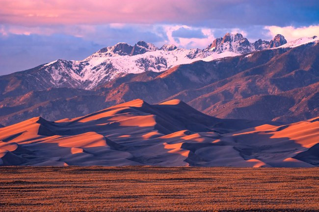
A huge dune below snow-capped mountains at sunset
Star Dune rises well above the other dune ridges with a distinctive pyramid shape.

NPS/Patrick Myers

Star Dune

Star Dune is currently tied with Hidden Dune (above) as the two tallest dunes in North America. It is a majestic dune now measuring 741 feet (225 m) from base to summit. While it can be hiked from the summit of High Dune on First Ridge, it's more direct, and less up and down, to access it via its base along the Medano Creek bed. From the Dunes Parking Lot, hike about 2 miles (3.2 km) south down the Medano Creek bed until the massive pyramid-shaped Star Dune comes into view. Follow a ridge to its summit.
GPS coordinates for Star Dune as of 2021:
37.7517639, -105.5580583

Average round trip hiking time for High Dune is 6 hours over 6 miles (9.6 km). There is no trail. Popular hiking applications are often inaccurate. Plan to take as much as 9 hours to hike roundtrip- if not acclimated to the high altitude and lower oxygen level. In warmer months, plan to start in early morning to avoid extreme dunes heat or thunderstorms.

 
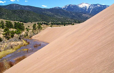
Dune slope, Medano Creek, Trees, and Distant Snow-Capped Mountain
Tall dune face above Castle Creek Picnic Area

NPS Photo

Eastern Dune Ridge

By high clearance 4WD vehicle, drive to Sand Pit or Castle Creek Picnic Areas. Or, with 2WD vehicle, drive to Point of No Return, then hike 3/4 mile (1.3km) to Sand Pit or 1.5 miles (2km) to Castle Creek. Castle Creek Picnic Area offers an impressively tall, steep dune face. Both areas have access to Medano Creek, which usually flows gently through the months of fall in this area.

There are no formal trails in this area and popular hiking applications do not show changes to the dunefield overtime and are often inaccurate. Explore on foot at will, but be prepared with sun protection, good shoes, and extra water.

 
Boy Hiking Mosca Pass Trail
Boy hiking Mosca Pass Trail, Great Sand Dunes National Preserve

NPS/Patrick Myers

Forested Trails

Montville Nature Trail

In summer, keep this hike as an option for afternoon as an escape from the heat of the dunes. Walk along a shady forested trail named for a late 1800s settlement, comprising 20 houses in its heydey. Rest near the trail's highpoint, where you'll find outstanding views of Mt. Herard, the dunes and the valley.

(Please be aware that hunting is permitted during legal seasons in Great Sand Dunes National Preserve, the higher mountainous areas above the dunes. Primary rifle seasons are in fall months. Check with a park ranger for details.)

Mosca Pass Trail

This trail follows a small creek to the summit of a low pass in the Sangre de Cristo mountains, winding through aspen and evergreen forests. Allow 2-3 hours to reach the pass; the trail is 3 1/2 miles (5.7 km) one way. American Indians and early settlers used this route for travel into the valley.

Sand Ramp Trail

This 11 mile trail is most commonly used as an access to various backpacking sites along the foothills, rather than as a destination trail for scenery, since it stays at the same elevation along the base of the mountains. Begin hiking the Sand Ramp Trail in Loop 2 of the campground or at Point of No Return Parking area. After the first two miles, much of this trail is sandy soil or pure sand, up and down along the foothills, so this hike can be grueling. Allow for more time than the mileage indicates.


Medano Pass 4WD Road

Driving this road requires 4-wheel drive (not recommended for small sport utility vehicles). A scenic drive any time of the year, it is especially spectacular in late September and early October when fall colors are at peak. Creek crossings can be hazardous in spring and the road is closed when winter conditions create hazards. For those without a 4WD vehicle, contact Mountain Master Off-Road Tours, or Great Sand Dunes Lodge for Jeep rentals or tours. Check current road conditions and detailed information.

 
Visit our keyboard shortcuts docs for details
Duration:
1 minute, 35 seconds

You'll be surprised this alpine paradise is part of Great Sand Dunes National Park and Preserve! July is the best month to visit for wildflowers and snowfields laced upon the cliffs. Check hiking details below. Choose Broadband/HD at lower right for clearest video, or lower settings for slower connections.

Also available to watch on YouTube

 
Visit our keyboard shortcuts docs for details
Duration:
42 seconds

This high-energy 40-second video with music shows a climb of Mount Herard (13,297 feet / 4053 m) in Great Sand Dunes National Preserve. You'll share their awe at the amazing view of the 30 square mile dunefield! Visual descriptions of scenes: 1) A truck drives through sand and water on Medano Pass Primitive Road 2) Backpackers hike through a meadow and forest, cross a stream, and set up a tent 3) Medano Lake sparkles in the sunlight 4) Hikers ascend steep tundra 5) Hikers overlook the dunefield and valley.

Also available to watch on YouTube

 
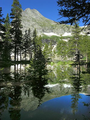
Lower Sand Creek Lake
Snowfields are often still melting into Lower Sand Creek Lake in early July.

NPS/Kris Illenberger

Alpine Trails

Medano Lake and Mount Herard

Please note: trails to alpine lakes all have significant tree downfall over them. Hikers can still make it to the lakes with effort, but livestock are not recommended.

Medano Lake Trailhead is accessed from the Medano Pass 4WD road. Beginning at 10,000' elevation, the trail climbs 2000' through lush meadows and forests, ending at an alpine lake at timberline. For advanced hikers, continue on to the summit of 13,297' Mount Herard for a spectacular aerial view of the dunes.

Music Pass, Sand Creek Lakes, and Other Alpine Peaks
A 2 1/2 hour drive from the Great Sand Dunes Visitor Center with a 4WD vehicle (see map below), and an 8 mile (13 km) round trip hike are required to reach Sand Creek Lakes. However, the alpine scenery is worth the effort, especially in mid-summer when patches of snow are still present on the peaks and flowers dot meadows and tundra. Check with a ranger for conditions before travel. Snow may block these trails from November into June.

Round Trip Hiking Mileages from Music Pass Trailhead

Lower Sand Creek Lake or Upper Sand Creek Lake: 8 miles (13 km)
Little Sand Creek Lakes: 16 miles (26 km)

Climbing the Peaks of Great Sand Dunes National Preserve

The Essential Guide to Great Sand Dunes National Park and Preserve, available in the visitor center store, has detailed climbing information for the peaks. Colorado climbing websites also contain trip reports from climbers with mileages, route options, and conditions updates. Marble Mountain is a gentle tundra hike to the north from Music Pass, but the other peaks require significant route-finding with potentially dangerous exposure to steep cliffs.

 
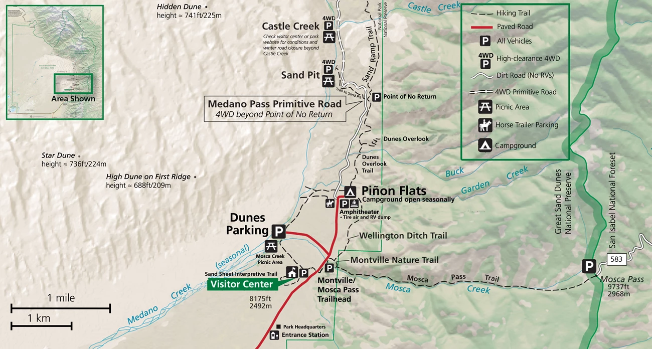
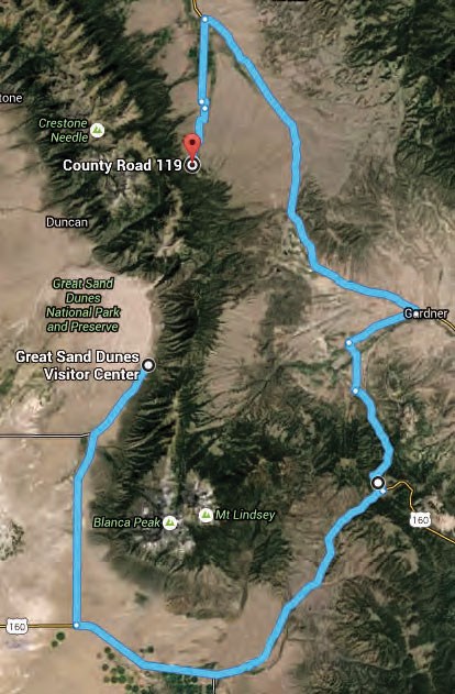
Map showing the driving route from the visitor center to Music Pass Trailhead

Driving Route from Great Sand Dunes Visitor Center to Music Pass Trailhead

Drive south on CO 150 to US 160. Turn left (east), and continue toward La Veta Pass. About 2 miles before La Veta Pass, look for the sign for Pass Creek Pass on the left (north). This all-season dirt road goes uphill for one mile, then down into the Wet Mountain Valley. When you arrive at a T intersection at a paved road, turn right toward Gardner. At Gardner, turn left (north) on CO 69. At 4.5 miles south of Westcliffe, turn off Highway 69 to the west at the sign for Music Pass and South Colony Lakes Trailhead. At the "T" junction, turn left onto South Colony Road. At the end of the ranch fence on the right, you'll see another sign for Music Pass.

2WD drivers should park where the Rainbow Trail crosses Music Pass Road. From here, walk 2.5 miles to Music Pass Trailhead.

4WD drivers may drive another 2.5 miles to the end of the road at Music Pass Trailhead.


Accessing Sand Creek Drainage from the West

Sand Creek and Sand Creek Lakes are also accessible from the west side of the Sangre de Cristo Mountains, but require long hikes. From Liberty Gate Trailhead, south of the town of Crestone on the north side of the national park, it is a 7 mile hike just to reach the lower part of Sand Creek where it flows around the dunefield. From there, it is an additional 10 miles hiking up the Sand Creek drainage to reach either of the Sand Creek Lakes, with 3,500 ft. elevation gain. The Sand Creek Trail crosses Sand Creek a few times as it ascends the drainage; in years of average to high streamflow, Sand Creek makes the trail uncrossable in early summer, generally the entire month of June.
From the main use area of the national park, Point of No Return Trailhead provides standard 2WD access to the Sand Ramp Trail. This grueling 11-mile trail, up and down through foothills woodlands and dunes, accesses Sand Creek on the north side of the dunefield. From there, it is an additional 10 miles hiking up the Sand Creek drainage to reach either of the Sand Creek Lakes, with 3,500 ft. elevation gain. The Sand Creek Trail crosses Sand Creek a few times as it ascends the drainage; in years of average to high streamflow, Sand Creek makes the trail uncrossable in early summer, generally the entire month of June.

With high-clearance 4WD, you can reach the Sand Ramp Trailhead along the Medano Pass Primitive Road. From this trailhead, it is a grueling 7 mile hike, mostly up and down through sand, to Sand Creek on the north side of the dunefield. From there, it is an additional 10 miles hiking up the Sand Creek drainage to reach either of the Sand Creek Lakes, with 3,500 ft. elevation gain. The Sand Creek Trail crosses Sand Creek a few times as it ascends the drainage; in years of average to high streamflow, Sand Creek makes the trail uncrossable in early summer, generally the entire month of June.

 
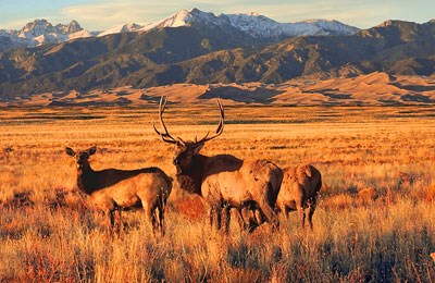
Three elk standing in grasslands with dunes and mountains in background
Elk are often seen in the park's grasslands at sunrise or sunset during quieter months.

NPS/Patrick Myers

Grasslands and Shrublands

The spacious grasslands and shrublands of the national park are the least visited area, yet they contain spectacular wildlife, migrating dunes, panoramic mountain views, and intricate beauty. See details on accessing grasslands in and around the national park.
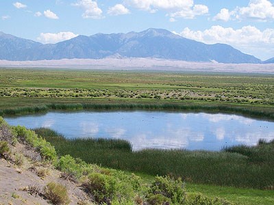
 
South Twin Lake
South Twin Lake is one of the wetlands west of Great Sand Dunes.  Though this lake is within national park boundaries, it is situated on private land managed by The Nature Conservancy.  Rangers occasionally lead hikes to this lake by permission from The Nature Conservancy.

NPS/Patrick Myers

Wetlands

Wetlands abound in the San Luis Valley, providing refreshing oases for wildlife and people in this high mountain desert. See details on accessing the wetlands in and around Great Sand Dunes National Park.

Last updated: December 5, 2023

Park footer

Contact Info

Mailing Address:

Visitor Center
11999 State Highway 150

Mosca, CO 81146

Phone:

719 378-6395
Great Sand Dunes Visitor Center main number

Contact Us