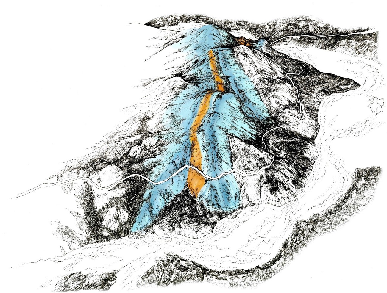
OverviewThe Pretty Rocks landslide intersects the Denali Park Road near its midpoint at Mile 45.4 and displaces 100 yards (90 m) of the full width of the road. In recent years this landslide has evolved from a minor maintenance concern to one that has caused substantial road restrictions. To learn more about the bridge construction project that began at Pretty Rocks in 2023, read about the Polychrome Area Plan and follow the Pretty Rocks Construction blog for updates. The Pretty Rocks landslide has been active since at least the 1960s, and probably since well before the Denali Park Road was built through this area in 1930. Before 2014, the landslide only caused small cracks in the road surface and required moderate maintenance every 2–3 years. However, in 2014, road maintenance crews noticed a substantial speed up. By 2016 the movement had increased further, a slump had developed in the road, and a monitoring program was begun. The rate of road movement within the landslide evolved from inches per year prior to 2014, to inches per month in 2017, inches per week in 2018, inches per day in 2019, and up to 0.65 inches per hour in 2021. 
NPS Photo 
NPS Photo By late August, 2021, park managers recognized that adding hundreds of truckloads of gravel into the slumping road to maintain a drivable surface was no longer tenable or safe, and they enacted a road closure west of Pretty Rocks. Since then, the movement of the landslide has continued to carry that section of road farther down the hillside and the road closure has remained in effect. Pretty Rocks is one of several known landslides in the Polychrome area and one of the more than 140 mapped unstable slopes along the entire Park Road (Capps et al., 2017). The Polychrome Area Plan was developed with this in mind and addresses solutions not just for Pretty Rocks but also for the nearby Bear Cave Landslide. Even though Pretty Rocks is currently our most problematic location, the National Park Service is working with the Federal Highway Administration to manage the park road proactively and holistically in order to restore and maintain access along the entire length of the road. 
NPS Photo Time-Lapse VideosA time-lapse camera is located on the west side of the landslide. The videos below show the continuous nature of the landslide over the course of months and years.
Visit our keyboard shortcuts docs for details
A time-lapse video of the Pretty Rocks landslide and construction site from June 17, 2024 to November 8, 2024. Note how the movement of the landslide speeds up and peaks in September due to summer temperatures warming the ice-rich permafrost underground, and then slows down as winter arrives. The busy construction season concluded in October after the first four trusses of the bridge were erected on the east side of the slide. No audio.
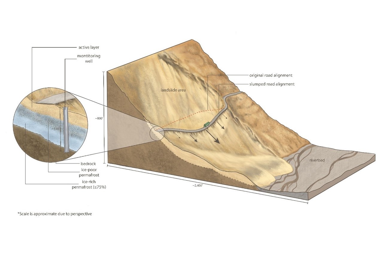
Climate Change as Causal AgentBased on climate data from 1950 to 2010, Denali National Park has experienced a temperature increase of 7.7°F ± 2.0°F (4.3°C ± 1.1°C) per century, the highest of all national parks (Gonzales, et al, 2018). A recent shift in mean annual temperatures in the area to near 32°F (0°C) (Swanson et al., 2021) combined with heavy rainfall events is believed to be causing permafrost to thaw, resulting in the recent acceleration of many landslides in Denali. In the case of Pretty Rocks Landslide, climate change has likely taken a problem previously solved by minor road repairs and made it difficult to overcome with short-term solutions. Temperature and precipitation increases are likely to continue, and the rate may worsen, over the coming decades.While these changes were predicted by modelers (Rupp and Loya, 2009), the magnitude of the change has been greater than expected. For example, the area where Eielson Visitor Center is located (Mile 66 [km 106]) reached an average mean annual temperature of 32.4°F (0.2 °C) from 2015-2019 (Sousanes, 2020); this exceeds the temperature of 29.8°F (-1.2°C) projected for 2040 by Rupp and Loya (2009). Geology of Pretty Rocks LandslideWe have learned about the subsurface of Pretty Rocks through multiple borings (drilling) in and around the landslide. While conditions are variable, a representative cross section is shown in the following scientific illustration by Laurel Mundy. All borings within the landslide contain permafrost, or ground that is at or below freezing for two or more years. The shallowest material, the active layer, thaws seasonally and is therefore not permafrost. Permafrost can be essentially ice free (ex. granite high on Mount McKinley), ice poor, or ice rich.Some of the substrate here is ice poor, meaning that ice volume is equal to or less than the pore space between debris. Some of the substrate is ice rich, meaning that ice volume exceeds the pore space between debris. Pretty Rocks contains abundant ice – we have drilled through up to 15’ (4.6 m) of 85% ice directly beneath the road. The ice-rich permafrost typically is positioned directly above the debris and bedrock interface. Slope inclinometers (instruments that measure displacement) indicate that most movement is occurring at this interface. 
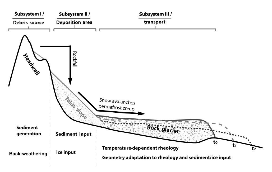
Illustration by Laurel Mundy However, Pretty Rocks and some other rock glaciers around the world have begun to advance quickly, with climate change as a major cause (Müller et al., 2016). Denali has many rock glaciers, likely thousands of them, and efforts are underway to identify and classify them. Some of these rock glaciers are currently advancing beyond their historic margins. 
Müller et al., 2016 (unmodified) The clay is very unstable on steep slopes like those at the road. The clay is also mostly frozen, but only barely – it is within 1°F (0.6°C) of thawing. Based on borings and surface mapping, the clay is known to extend hundreds of feet into the subsurface and laterally to the north-northeast all the way to the East Fork of the Toklat River just north of East Fork bridge. Where this same layer intersects the East Fork River, landslides similar to the one at Pretty Rocks are occurring but do not intersect the road. This long, vertical layer of unstable clay is the reason that we cannot simply dig the undesirable material out and put the road on competent bedrock farther in on the cliff face. 
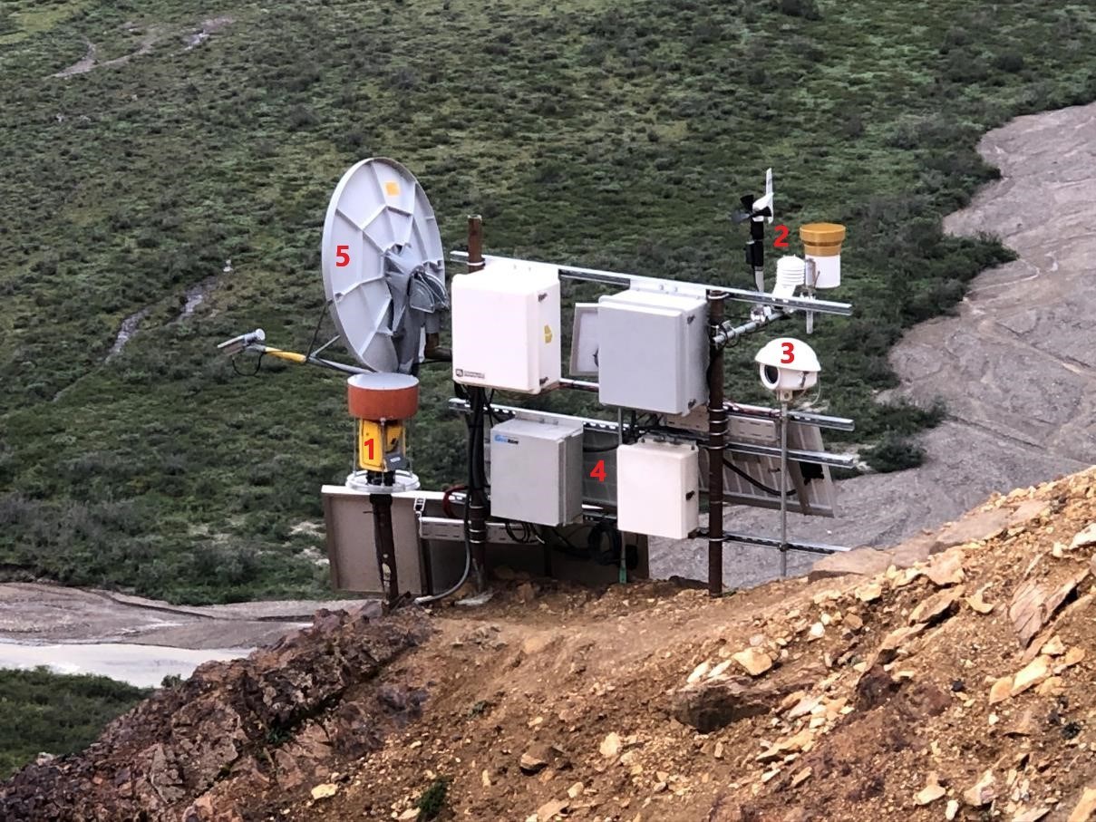
Tracey Faber Monitoring System for Pretty Rocks LandslideThe Pretty Rocks landslide monitoring system is located on a stable bedrock ridge below the road and above the western side of the landslide. The robotic total station is a surveying instrument that uses a laser to accurately measure distances and angles from about 35 small prisms (mirrored reflectors) installed within and around the landslide. After staff complete initial measurements manually in the field, the total station repeats the measurements on a defined interval (typically every hour). The weather station includes a shielded thermometer, anemometer (wind speed and direction), and tipping-bucket rain gauge. We create time-lapse videos from photos taken every few hours.
NPS Photo Above: Annotated image of the Pretty Rocks near-real-time monitoring system. To improve visitor safety and understand the movement of the Pretty Rocks landslide, we built a near-real-time monitoring system. The system has five main components: 1) a robotic total station; 2) a weather station; 3) a time-lapse camera; 4) a solar-power system; and 5) a satellite internet system ReferencesCapps, D. M., R. Rosenberg, A. Collins, D. A. Anderson, S. Hooper, H. Rogers, B. Collins, and E. Bilderback. 2017. Geohazards Risk Assessment of the Denali National Park Road, in Proceedings North American Symposium on Landslides, Roanoke, VA. Association of Environmental & Engineering Geologists. Gonzalez, P., F. Wang, M. Notaro, D. J. Vimont, and J. W. Williams. 2018. Disproportionate magnitude of climate change in United States national parks. Environmental Research Letters 13: 12. Müller, J., Vieli, A., and Gärtner-Roer, I, 2016. Rock glaciers on the run – understanding rock glacier landform evolution and recent changes from numerical flow modeling, The Cryosphere, 10, 2865–2886, 2016. Creative Common Attribution 4.0 License. Rupp, S. and W. Loya. 2009. Projected climate change scenarios for Denali National Park & Preserve: University of Alaska Fairbanks, Climate change summary reports of National Parks, Preserves and Monuments. Sousanes, P. 2020. Analysis of temperatures from the two stations in Denali National Park and Preserve that best characterize the Pretty Rocks location along the Denali Park Road. Fairbanks, Alaska: National Park Service. Swanson, D. K., Sousanes, P. J. & Hill, K. 2021. Increased mean annual temperatures in 2014-2019 indicate permafrost thaw in Alaskan national parks. Arctic, Antarctic, and Alpine Research, 53, 19. |
An official website of the United States government
Here's how you know
Official websites use .gov
A
.gov website belongs to an official government
organization in the United States.
Secure .gov websites use HTTPS
A
lock (
) or https:// means you've safely connected to
the .gov website. Share sensitive information only on official,
secure websites.

