
Research Report
Creating Cultural Resource Spatial Data Standards
by Deidre McCarthy
Throughout the field of historic preservation, accurate locational data remains a fundamental component to understanding cultural resources. Examining resources in a geographic context allows preservationists to study the interaction of those resources and to identify larger trends across landscapes. Using technological tools such as Geographic Information Systems (GIS) to better manage and protect our cultural resources is, therefore, increasingly critical. With the implementation of such systems, however, comes the need for improved data management, which in turn necessitates the development of standardized elements to facilitate data sharing and dissemination.
The Need for Data Standards
Spatially, each resource is a single entity. Yet experts in various disciplines view those individual sites from differing perspectives, be they architectural, archeological, or ethnographic. These viewpoints manifest in a series of separate databases cataloging the same resources with terminology for characteristics specific to each field of study. Geography can integrate these disparate databases by using one location to reference multiple sources of descriptive information. To accomplish this efficiently and effectively, locational data must be standardized to ensure consistency and quality.
Historic preservation programs throughout the federal government rely on cultural resource geospatial information to comply with preservation laws, regulations, and guidelines that call for the collection and maintenance of inventory information, such as the National Historic Preservation Act (1966), Archaeological Resources Protection Act (1979), Abandoned Shipwreck Act (1987), or Historic Sites Act (1935). As a result, numerous sources of descriptive and spatial data about cultural resources exist within a single agency, as well as with other federal agencies and their partners, primarily State and Tribal Historic Preservation Offices.
After 40 years of conducting surveys, the volume of cultural resource geospatial data has reached a critical mass. The data are difficult to access in a paper form, where they currently reside in many cases. Paper records limit the ability to perform efficient spatial analyses and distribute data. Thus, the conversion of paper cultural resource inventories to a digital geospatial format is essential. A digital format will allow all government agencies not only to better understand our cultural resources, but also comply with laws and regulations, share data when necessary, and ultimately better protect the resources themselves.
Digital data are the foundation for cultural resource GIS tools. Beyond computerized cartography, GIS software represents real world features as map layers according to feature type, such as roads, building footprints, or county boundaries. By stacking map layers on top of each other, users view the layers geographically in relationship to each other and to the earth. Attribute information describes what each map feature stands for in a database, allowing users to query the data based on text descriptions or on the geography itself. In this way, GIS holds the key to integrating our cultural resource data sources and enabling cultural resource managers to explore new approaches to using the data, which enables more complete resource protection.
Currently, no national standards for cultural resource spatial data exist. Without standards to direct recordation efforts, it is difficult to fully realize the benefits of GIS tools, and the ability to exchange data among agencies or organizations engaged in cultural resource management is severely hampered. Standards give the agencies involved in inventory creation a set of guiding principles to create the necessary data in a consistent and accurate way. Users can also evaluate the data they receive against such standards to make better informed decisions regarding the data itself, thus improving the quality of the conclusions generated through GIS tools.
Interagency Cooperation
OMB Circular A-16 (revised in 2002) defines the Federal Geographic Data Committee (FGDC) as an interagency organization promoting the coordinated development, use, and dissemination of geospatial data on a national basis. The FGDC, chaired by the Department of the Interior is composed of 19 members representing the Executive Office of the President and independent Federal agencies. Organized into subcommittees based on individual data themes and cross-cutting working groups, the FGDC creates the National Spatial Data Infrastructure and is the framework within which all federal agencies operate to generate and share their geospatial data.
The same OMB Circular designates the National Park Service (NPS) as the primary agency to steward the cultural resource spatial data theme, which includes the responsibility for the establishment of data standards. Within the NPS, the Cultural Resource GIS Facility (CRGIS) has been given the lead in this effort inside the NPS and through the FGDC.
CRGIS brought together GIS and cultural resource subject matter experts within NPS and developed a draft set of cultural resource spatial data standards as well as an implementation model for use by the park service. CRGIS tested these working standards when devising a strategy for identifying and evaluating all properties affected by Hurricane Katrina in Orleans Parish, Louisiana, at the request of the Federal Emergency Management Agency (FEMA), enabling their compliance with Section 106 of the National Historic Preservation Act.
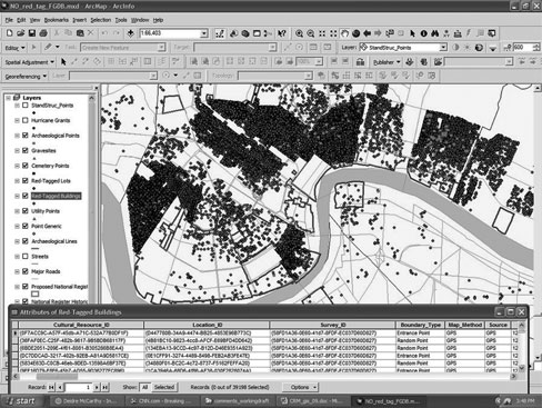
The successful application of the standards during the largest cultural resource catastrophe since the enactment of the National Historic Preservation Act clearly demonstrated the benefits of utilizing GIS tools in disaster response. It underscored the need for establishing data standards to facilitate the efficient and timely exchange of data among federal, state, tribal, and local agencies. The ability to integrate disparate data sources, perform sophisticated spatial analyses, and provide easy access to information proved essential to FEMA as well as for the protection of resources following the disaster. (Figure 1)
Figure 1. An example of the GIS used in response to Hurricane Katrina, showing the cultural resource locations collected as part of FEMA's initial survey and identification, as well as the subsequent treatment measures to comply with Section 106 of the National Historic Preservation Act. The accompanying table shows some of the data collected to describe the geography itself and to meet the draft cultural resource spatial data standards. |
Building on this model, and the lessons learned from its performance during the Katrina response, CRGIS engaged in the formal NPS spatial-data-standard-creation process, under the direction of the NPS GIS Council. CRGIS then published a working draft of the standards in August 2008, which were distributed throughout the agency for comment. Incorporating the comments received, CRGIS and the Cultural Resource Subcommittee of the NPS GIS Council revised the draft for a similar NPS-wide release in July 2009.(1) After the review and comment period, a final draft of the standards will be submitted to the GIS Council for approval. The Cultural Resource Subcommittee will then put the standards into practice within NPS.
On a parallel path, CRGIS formally entered the FGDC standard creation process in December 2007 with a proposal defining the need for cultural resource spatial data standards for all federal agencies. Approved by the FGDC Standards Working Group the following February, CRGIS then turned to the Subcommittee on Cultural and Demographic Data to shepherd the standards they had crafted for NPS and then edited for the broader FGDC audience through the FGDC review process.(2)
Because consensus building was essential to this endeavor, in March 2009, CRGIS hosted a GIS Summit in Washington, DC, inviting over 75 federal, state, tribal, local, academic, and private sector participants to help direct the FGDC standard creation effort. From the participants, and through assistance of FGDC staff, CRGIS gained new insight that redefined the basic guiding principles for creating the cultural resource spatial data standards. At the summit, CRGIS and the other participants settled on establishing cultural resource spatial data transfer standards as a first step. Similar to the internal NPS process that culminated in the draft standards tested in the wake of Hurricane Katrina, CRGIS formed a Cultural Resource Work Group within the FGDC to begin producing the standard itself.(3)
The creation of spatial data standards for the National Park Service and the larger FGDC involves public input, like that solicited at the Summit in March, and invites broad public review as well as the testing and modeling of the standards before final approval. By necessity, however, the FGDC standard will affect all federal agencies and by association the State and Tribal Historic Preservation Offices as well as local governments with whom they work, thus requiring high levels of coordination and wide-ranging review. The internal NPS cultural resource spatial data standards that evolved after testing in Louisiana soon should be in final draft. The FGDC standards will likely take several years to reach the same stage. By developing the two standards in conjunction with each other, however, CRGIS hopes to ensure their compatibility.
Both drafts address the geographic representation of cultural resources, link these representations to external databases that contain descriptive information, document how the geographic data was created and its specific parameters, and find ways to ensure security of sensitive cultural resource data. The primary concentration of the standards remain feature level metadata (data about the data) which records the history of the geographic data, providing for the combination of cultural resource geographic data from multiple sources and presenting a means of sharing information easily. Both the NPS and FGDC standards purposefully do not address the descriptive information about each cultural resource in an effort to preserve the myriad of perspectives offered by experts in various disciplines.
Conclusion
Locational data will always play a critical and fundamental role in understanding cultural resources. Creating standards to improve the quality and accuracy of that data, to expand the accessibility of the data, and to enhance the capability to share the data will only lead to better cultural resource management. Taking advantage of the GIS tools that accompany such enriched data will help historic preservationists investigate cultural resources with new and thoroughly innovative approaches.
Contact CRGIS for additional information on the cultural resource spatial data standards creation process within the NPS and through the FGDC.
About the Author
Deidre McCarthy is a historian and certified GIS professional (GISP) with the Cultural Resource Geographic Information Systems Facility, Heritage Documentation Programs. She can be reached at deidre_mccarthy@nps.gov or (202) 354-2141.
Notes
1. For more information on the composition of the NPS GIS Council, see www.nps.gov/gis. Cultural Resources are but one part of this group that includes various regional contacts, network coordinators, and personnel within programs such as inventory and monitoring, facilities management, fire, land resources, air quality, geology, remote sensing, vegetation mapping, the Midwest Archeological Center, and National Trails, as well as the Natural Resource GIS Coordinators.
2. The Subcommittee on Cultural and Demographic Data (SCDD) of the FGDC is composed of members from the federal agencies collecting, financing collection, or applying cultural and demographic geospatially referenced data. (See http://www.census.gov/geo/www/standards/scdd)
3. The Cultural Resource Working Group (CRWG) includes representatives of federal agencies, the SCDD of the FGDC, State Historic Preservation Offices, Certified Local Governments, the National Conference of State Historic Preservation Offices, universities, and consultants in the private sector.