Trail Maps and Descriptions


Ready to hit the trails? This page is your source for trail maps and directions. Use the quick navigation link above to jump to the trails in the park unit of your choice.

Find more information about the units of the preserve on our Places to Go page.


blue metal trail blaze nailed to a tree
Look for blue blazes on the Kirby outer loop.

Kirby Nature Trail

1.5 to 2.5 miles roundtrip
Kirby Nature Trail Map | Turkey Creek Unit Trails Map

Three loop options, ranging from 1.5 to 2.5 miles, pass through several plant communities, from baygalls to cypress sloughs to the riparian zone along Village Creek. An interpretive trail guide is available at the visitor center for a small charge. The outer loop is marked with blue trail blazes.

Hikers can continue north from this trail to the Sandhill Loop Trail and the Turkey Creek Trail.

The trailhead is located on FM 420, 2.5 miles east of US 69/287 and the visitor center.

 
green metal trail blaze nailed to a tree
Look for green blazes on the Pitcher Plant Trail.

Pitcher Plant Trail

1-mile loop
Carnivorous Plant Trails Map | Turkey Creek Unit Trails Map

The first quarter-mile of the Pitcher Plant Trail passes through longleaf pines into a large bog of pitcher plants and sundews. The 1-mile trail continues through a mixed woodland, joining the Turkey Creek Trail for a short distance before looping back to the trailhead. This loop trail is marked with green trail blazes.

The trailhead is on County Road 4850, about 2 miles south of FM 1943 and about 4.5 miles east of Warren.

 
red metal trail blaze nailed to a tree
Look for red blazes on the Turkey Creek Trail.

Turkey Creek Trail

17 miles one-way
Turkey Creek Unit Trails Map

Six trailheads provide access to different parts of this 17-mile trail, providing opportunities for hikes of varying distances. The trail roughly parallels Turkey Creek and passes through several plant communities, from hardwood forests to cypress sloughs.
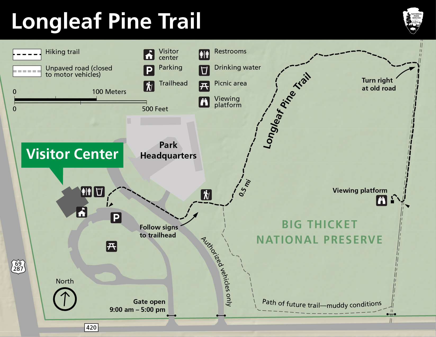
Hikers can access this trail on FM 1943, 3.5 miles east of Warren; at the Pitcher Plant Trail, 2 miles south of FM 1943 on County Road 4850; on County Road 4825; along Gore Store Road, 4 miles east of US 69/287; and on FM 420 at the Kirby Nature Trail. This trail is marked with red trail blazes.

 
yellow trail blaze nailed to a tree
Look for yellow blazes on the Sandhill Loop.

Sandhill Loop Trail

1-mile loop; reached via 5- or 9-mile roundtrip hike
Sandhill Loop Trail Map | Turkey Creek Unit Trails Map

This trail leads through a rare "arid sandyland" ecosystem, home to prickly pear cactus and other desert plants. Despite the region's ample rainfall, the sandy soil in this pocket of the woods doesn't hold much moisture, so desert plants thrive here. The forest is much more open and sunny here than in other parts of the Big Thicket.

From the south (5 mi. roundtrip): Start at Kirby Nature Trail (on FM 420) and go north on either loop option, eventually reaching a junction with a metal bridge across Village Creek. Cross the bridge and continue north on the Turkey Creek Trail (red blazes) for 0.8 mile. Immediately after a second metal bridge crossing is the junction with the Sandhill Loop (yellow blazes). Go left or right around the loop.

From the north (9 mi. roundtrip): Take the Turkey Creek Trail south from Gore Store Road for 4 miles to reach the Sandhill Loop. The loop is marked with yellow trail blazes.


Hickory Creek Savannah Unit

Sundew Trail

1-mile loop
Carnivorous Plant Trails Map

Both the inner 0.3-mile loop and the outer 1-mile loop pass through a small bog of pitcher plants. The inner loop continues through a savannah that has abundant summer wildflowers, while the outer loop winds through a woodland composed primarily of longleaf pines. This is one of the best places in the preserve to see birds and wildflowers, as well as the tiny red sundew plants.

The trailhead is on County Road 1910, ½ mile south of FM 2827 and approximately 7 miles north of the visitor center.


Beech Creek Unit

Beech Woods Trail

1-mile loop
Beech Woods Trail Map

Hikers in the Beech Creek Unit can follow either the Beech Woods Trail, which makes a 1-mile loop, or a former dirt road that extends from the trailhead for 6 miles through the unit.

The Beech Woods Trailhead is located on FM 2992, 1.5 miles north of FM 1013.

NOTE: Hunting is allowed in the Beech Creek Unit during the fall/winter season. The trail is not in the hunting area. Hikers who explore beyond the trail during hunting season are encouraged to wear Hunter Orange.


Big Sandy Creek Unit

Beaver Slide Trail

1.5-mile loop
Big Sandy Creek Unit Trails Map

The Beaver Slide Trail makes a loop of 1.5 miles near Big Sandy Creek. It is heavily wooded and is an excellent short hike on which to see cypress trees.

The trailhead is on FM 943, approximately ¼ mile west of the intersection with FM 1276. Parking is along the highway shoulder.

Big Sandy Trail

18 miles roundtrip
Big Sandy Creek Unit Trails Map

The Big Sandy Trail has more topography than other trails in the preserve, and goes through many different ecosystems along its 9-mile length. It is the only trail in the preserve that is open to horseback riding and bicycling as well as hiking.

The trailhead is on the Sunflower Road, 3 miles west of FM 1276 near Dallardsville.

NOTE: Hunting is allowed in this portion of the Big Sandy Unit during the fall/winter season. During hunting season, hikers are encouraged to wear Hunter Orange.

Woodlands Trail

5.4-mile loop
Big Sandy Creek Unit Trails Map

The Woodlands Trail consists of three loops of 3.3 miles, 4.5 miles, and 5.4 miles, giving hikers several distance options. This trail traverses a variety of plant communities, including the Big Sandy Creek floodplain and dense stands of hardwood trees.

The Woodlands Trailhead is located on FM 1276, 5.9 miles north of Dallardsville and 3.3 miles south of US 190.


Menard Creek Corridor Unit

Birdwatchers Trail

1 mile roundtrip

The Birdwatchers Trail, located at the confluence of Menard Creek and the Trinity River, provides good views of the sandbars along the Trinity River, as well as the opportunity to see many types of birds.

From FM 787 in Romayor, head north on FM 2610, then turn left onto County Road 2161, then left on Forest Park. Follow Forest Park into the woods until you reach the trailhead.


Headquarters Area

Just east of the Big Thicket National Preserve visitor center and headquarters lies an expanse of wetland pine savannah known informally as the Solo Tract. There are no trails in this area, but visitors are welcome to wander among the longleaf pines and look for birds, wildflowers, and carnivorous plants.

From the visitor center, walk or drive east along FM 420 to the second driveway on the left. Walk around the locked gate to enter this area.

Last updated: November 18, 2023

Park footer

Contact Info

Mailing Address:

6044 FM 420
Kountze, TX 77625

Phone:

409-951-6700

Contact Us