Last updated: November 5, 2020
Article
Sky Island Fire Ecology
Explore the complex fire history of southern Arizona's sky islands, with an emphasis on Chiricahua National Monument. Three different fire regimes (Pre-1870; Fire Suppression; and Intensification) have shaped the landscape visitors experience today. What effects from fire can we see today? What will the future bring?
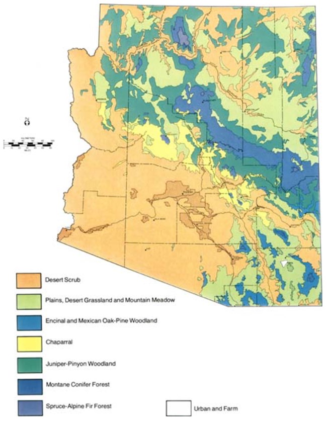
Brown, D.E. 1973. The Natural Vegetative Communities in Arizona. Map. 1:500,000 scale. (Arizona Resources Information Systems, cooperative publication 1). Phoenix, Arizona.
The fires of the 21st century are a serious problem. Uncharacteristically large, intense fires disrupt ecosystems that historically experienced frequent, but low-intensity wildfire. These large fires also threaten human communities in the rapidly-growing wildland-urban interface. A key recommendation of the 2007 Statewide Strategy for Restoring Arizona’s Forests was that “The Arizona State Legislature, county and local governments, tribal governments, and state agencies should develop land use policies and practices that support forest restoration, community protection, and fire management efforts.” (Recommendation 2.2, p.9).
The Eco-Geography of Vegetation and Fire in Arizona
Vegetation (plants in a specific area) and fire regime vary naturally in relation to climate, topography, and soils. Arizona has tremendous variety in these factors (Figure 1). In terms of land forms and ecology, the state can be divided roughly into three parts. To the north, the high Colorado Plateau is largely forested. The Colorado Plateau is also dissected by deep arid canyons, like the Grand Canyon. A vast desert landscape covers the southwestern part of the state. In southeastern Arizona, low desert scrub and grassland are punctuated by mountain ranges. Some of these ranges rise as high as 10,000 feet—often referred to as the “Sky Islands” or “Madrean Archipelago."
The Sky Islands of the American Southwest and northern Mexico form an ecological convergence zone. The Rocky and Sierra Madre Mountain ranges and the Chihuahuan and Sonoran deserts come together. A remarkable diversity of species and communities results. These sky islands are a regional biodiversity hotspot. Steep mountainsides cut by sharp canyons create complex vegetation patterns. Cooler, moister, higher elevations support species mainly from the Rocky Mountains. Species from the Sierra Madre are prevalent in the lower to mid-elevation, arid (dry) zones. Sky islands can encompass plant and animal species from:
- Lowland Chihuahuan and Sonoran desert scrub and desert grassland;
- Mid-elevation piñon pine-oak-juniper woodland, chaparral, Madrean pine-oak forest, and Arizona pine forest;
- High-elevation ponderosa pine forest, montane mixed conifer forest, and subalpine spruce-fir forest.
A Mosiac Landscape
Sky Island sites like Chiricahua National Monument resemble a mosaic, rather than a staircase, of zones. A person can walk, for example, with little change in elevation, and still experience many natural communities. Echo Park or the Natural Bridge Trail are good examples. Still, this plant mosaic shifts in elevation. You leave more arid, open communities behind and encounter wetter, closed communities. Hike up the Mushroom Rock Trail to Inspiration Point to experience this phenomenon.It’s helpful to divide up natural communities in Chiricahua National Monument into the following:
● desert grasslands and savanna, along the park’s southern and western borders,
● riparian forest (Arizona sycamore, Arizona cypress, Velvet ash), along streambeds,
● chaparral (low shrubs, sometimes forming dense stands), on steep slopes and exposed sites,
● piñon-juniper-oak woodland, outside canyons throughout the park,
● lower pine-oak forest (Chihuahua and Apache pines; Arizona white and Emory oak), in lower canyons, and
● upper pine-oak forest (Arizona pine, Douglas-fir, silverleaf oak), in upper canyons and higher elevations.
This primer will focus on chaparral, woodlands, and forests, the most common vegetation types in the park. Scientific names of species are found in Appendix 1.
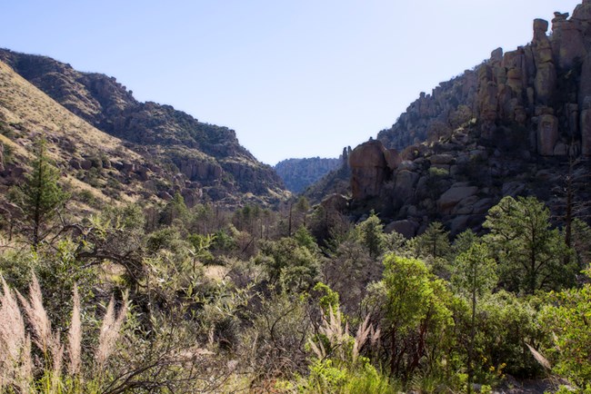
NPS/Dischinger
A spark, dry conditions, and continuous fuel
Topography and fire influence vegetation patterns at Chiricahua. Wildfire has three requirements: a spark, sufficiently dry conditions, and continuous fuel. In the Sky Islands, lightning during dry, spring conditions often starts fires. In fact, lightning frequency is extremely high in the Sky Islands. Ridgetops and lowland grasslands are thought to have been common ignition points. Fire would then spread up or down canyons.Indigenous people across the Americas, throughout time, used fire for different purposes. Were historic fires in the Chiricahua Mountains set by Apache? Knowledge of Apache use of fire is fragmentary. Based on research, fire frequency in the mountains was higher during times of warfare. Fire might have been an Apache tool of war with the Spanish and Americans. Even so, evidence to date suggests that most fires were lightning-caused. Lightning continues to play a key role in igniting wildfires. Today, many wildfires are set by humans, whether by accident or on purpose.
The other two requirements for fire—dry conditions and continuous fuel—vary with climate and vegetation. Fires are rare in deserts, which are dry enough but lack continuous fuel. In moister grasslands, woodlands, and forests, fuels are more continuous and conditions still dry enough for fires to occur. Under natural conditions, this limits fuel accumulation and fosters low-intensity, surface burns. Madrean pine-oak and Arizona pine forests are examples of these types of ecosystems.
In mixed coniferous forests at the highest elevations, fire regimes are more complex. On north-facing slopes, with spruce and fir, moist conditions limit fires to unusually hot/dry years. Long intervals between fires lead to fuel build-up and high-intensity fire. This often leads to stand replacement. On drier, south-facing slopes, with ponderosa pine and Douglas-fir, fires range widely. Fires could be low to high-severity, depending on weather.
A. Barton
Changing Fire Regimes
Our description of the fire regimes of the Sky Islands so far has been historical. Fires in pre-Euro-American times are not the fire regimes of today. We can divide the history of fire regimes into three distinct eras for the Southwest.- naturally frequent fires before Euro-American settlement, which maintained largely open vegetation;
- a 20th century period with few fires because of livestock grazing and active fire suppression. This led to landscape-scale surges in tree density and fuel; and
- a contemporary era of large, intensified wildfires.
Natural Fire Regime Before Euro-American Settlement (up to 1870)
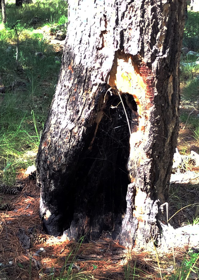
Researchers studying fire regimes in the Southwest sought out Chiricahua National Monument. Tom Swetnam, Chris Baisan, and their colleagues at the University of Arizona's Laboratory of Tree-ring Research started research in Rhyolite Canyon in the 1980s. How did they figure out the fire regime of this area from centuries ago? Many fire-adapted tree species have bark thick enough so surface fires injure but don’t kill them. Such “fire-recorder” trees are readily apparent, as they bear large triangular wounds. These wounds have black char on their lower trunks and are called cat faces (see Figure 2). Look for cat faces on the Apache, Arizona, and Chihuahua pines in the monument.When a fire damages the trunk, it also leaves a clear mark on the wood inside the trunk, on an annual tree-ring. Because of a lack of bark on the cat face, the next fire easily damages the tree. Its signature is once again on the ring for that year. Once injured, trees can continue to add fire scars for as long as they live. To reach the wood bearing these scars, researchers use a few different methods. They can take an increment core, but more often they will excise a small horizontal section from the tree. These wood sections are then sanded and polished. Now the tree-rings and fire scars are exposed. The rings are cross-dated with other dated trees to verify ring chronology. In this way, exact years of past fires are recorded. A history of fire regime patterns in an area can be established by examining many fire-scarred trees.
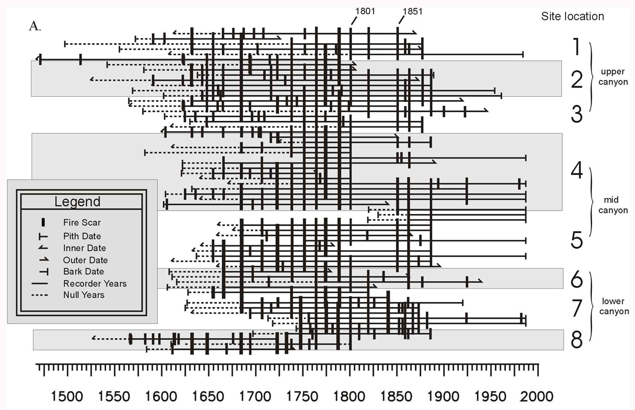
Fire chronology in Madrea pine-oak forest in Rhyolite Canyon, Chiricahua National Monument, Arizona (Swetnam and Basian 2001).
What causes that final pattern? Fires tended to occur in drier years following a moist period. Dry conditions promoted fire spread. Moist conditions caused fine fuel buildup of grasses and shrubs. Later the fuel buildup would carry fires across the landscape in hot/dry years. The fires recorded in Rhyolite Canyon also exhibit synchrony with other sites. Fires occurred across the entire Southwest around the same time. These records suggest that region-wide climate patterns are important in controlling wildfire. These major climate patterns are, in turn, controlled by the hemispheric-scale Pacific Ocean cycles of El Niño-La Niña.
Pine-oak pine forests in the Chiricahua Mountains have been studied the most. We know much less about natural fire regimes in other vegetation types. The species occurring in these other communities are generally killed by above ground fires. These species do not record fire history. Research on these tree species and the fire history of the canyons, points to mixed fire regimes, not surface fires. In chaparral, high-intensity fires killed most plants above ground. These high-intensity fires probably occurred every 20-100 years. In sheltered canyons, with Arizona cypress and piñon, mixed-intensity fires likely occurred every 80-400 years.
The landscape of Chiricahua National Monument supports a diverse set of plant communities. Variety in topography and vegetation probably caused differences in fire behavior from place to place.
NPS/Faraway Collection 86-16-0718 226
Fire-suppression Era (1880-1994)
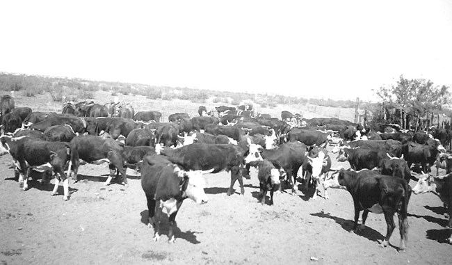
The second fire regime era—with a decline in fire frequency—is seen in the fire chronology as well. Starting in the 1880s, fires stopped in Rhyolite Canyon, and throughout the Southwest. This shift coincides with the onset of fire exclusion because of livestock. Cattle and sheep drastically reduced grass cover (fine fuels) and created fire breaks from cattle trails. By the early 1900s, active fire suppression began in earnest. Fire no longer was a dominant influence across the Southwest. What seemed like a good idea at the time—saving natural resources from fire—turned out to a be a misguided policy. The consequences are a continuing, modern-day challenge for land management. Historic and contemporary photographs reveal the increase in forest cover in the monument from fire suppression.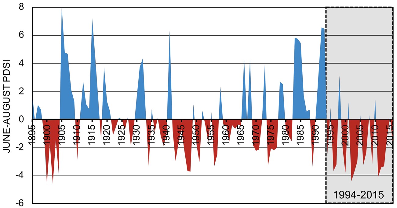
Fire Intensification Era (1994-present)
At least for the Chiricahua Mountains, the third fire regime era—intensification—started in 1994. That year was the first in a long and continuing series of drought years (Figure 4). The Rattlesnake Fire was propelled by more than a century of fuel build-up and dry conditions. The fire was lightning-caused. It burned nearly 25,000 acres on the east side of the mountains, on the Coronado National Forest. About 30% of the fire was moderate- and high-severity in areas that would have burned at low-severity in pre-settlement times. Chiricahua National Monument escaped the effects of the Rattlesnake Fire.Then, in 2011, the Horseshoe Two Fire burned 223,000 acres. It burned about 75% of the Chiricahua mountain range, including the monument. More than 40% of the fire burned at moderate- and high-severity. The fire destroyed 23 structures and cost over $50 million to fight. At peak operations, 1379 personnel battled the fire. The Horseshoe Two Wildfire was probably started by people. It began in May and burned into June, before the monsoon rains. The fire spread very rapidly because of extremely low moisture and high winds.
The ecological effects were profound. The fire killed trees across entire mountainsides. After the fire, monsoon rains gouged deep erosion channels, and caused severe flooding. In Chiricahua National Monument, the impacts are still evident everywhere. 2011 was one of the driest years on record, and brought massive fires to the Southwest (Figure 4). Over one million acres burned in Arizona alone, including the largest in state history, the Wallow Fire. Powered by fuel buildup and climate change, the fire intensification era in the Southwest continues today. The fire intensification era is causing economic hardship, human tragedy, and ecosystem disruption.
A. Barton and H. Poulos
Effects of Changing Fire Regime on Natural Communities
How have these dramatic shifts in fire regime changed the vegetation of Chiricahua National Monument? Ecologists divide vegetation characteristics into three categories: physical structure, process, and species composition. Structure refers to the sizes and density of trees, the height of the canopy, the layers of the forest, the amount of dead wood (snags, logs, branches, etc.). The term process captures the chemical and biological flows (e.g. photosynthesis), cycles (e.g. nitrogen), and events (e.g., droughts) that connect organisms to their environment and each other. Composition is the mixture of species on a site, including the diversity and types (e.g., conifers).
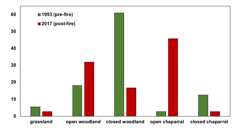
Structural changes in forests are the most obvious impact of changing fire regimes. During the pre-settlement era, fire maintained open vegetation. Many layers of trees, shrubs, and grasses, and low amounts of dead wood on the forest floor was normal. Fire suppression created denser, shadier communities, with higher levels of dead organic matter. The Horseshoe Two Fire dramatically reversed this trend. The fire caused widespread loss of forest cover. It converted closed forest sites to open shrubby chaparral. Figure 5 shows a startling loss of closed forest and increase in open chaparral because of the fire. At least for the short run, all the dead trees and other plants could amplify the chance of more fire in the future.
We know less about the impacts of changing fire regime on process. Still, several alterations in response to recent wildfires are clear in the Chiricahua Mountains. The loss of plant cover destabilized soils. During heavy summer rains, this leads to widespread erosion. When the soil can't absorb rain fast enough, water fills the washes, and carries parts of trees, rocks, and other debris. These flash floods filled with debris can deepen gullies and add soil to streams.
High-intensity fire reduced the amount of soil nitrogen, and other nutrients as well. Nitrogen is an important soil nutrient for plant growth. Little is known about the impacts of fire on soil micronutrient concentrations or on the microbial community. These help maintain healthy soil conditions, and were likely also disrupted.
A large amount of carbon was stored in these ecosystems—in live trees, dead wood, and soil. This carbon was released into the atmosphere when it burned. These forests shifted from carbon sinks to sources (i.e. releasing rather than storing carbon).
Changing fire regimes also transformed plant species composition in Chiricahua National Monument significantly. Plants with fire tolerance strategies are more common than others. Woody plants have evolved to have many adaptations for living in fire-prone environments. These adaptations are grouped into three strategies: fire resistance, resprouting, and fire seeding.
A. Barton
Plant Survival Strategies
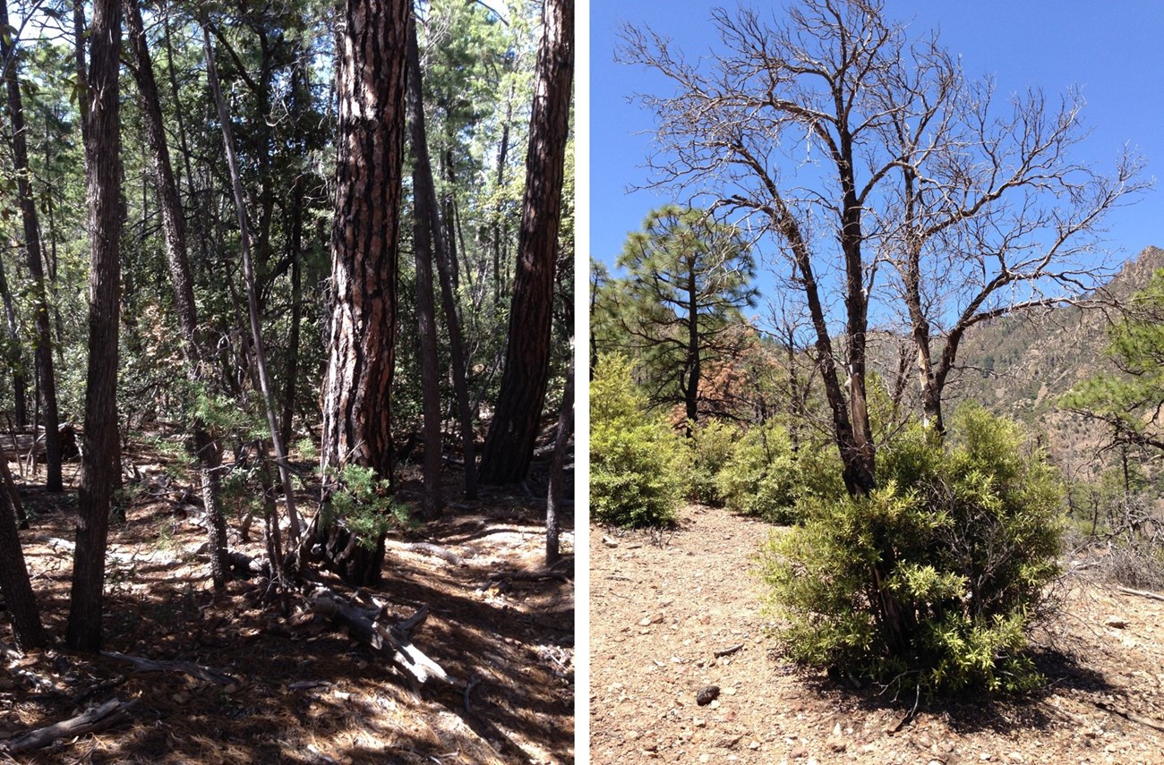
Fire resistant species, like Apache and Arizona pines, have thick bark and branch-free lower trunks. These adaptations allow mature trees to survive all but high-intensity fire (Figure 6).Other plants, such as oaks and trembling aspen, are readily top-killed by fire. They resprout prolifically from the stump, roots, or damaged trunks that survive even high-intensity fire (Figure 6).
Fire seeders produce seeds that germinate after wildfire. Fire-sensitive Arizona cypress, for example, are killed by fire. Cypress cones open and release seeds in fires—a term called serotiny. Their seeds enjoy mineral soil (i.e. no leaf litter) and high light levels in the post-fire environment. These trees have the capacity to quickly replace the former stand. Cherries take a different approach to the seeder strategy. Their seeds lie dormant in the soil until stimulated to germinate by the open conditions created by fire.
Not all species occur at the extremes of these strategies. For example, very large Arizona white oaks can survive low-severity fires, but resprout when they are top-killed. Chihuahua pine is a jack-of-all-trades. These pines have thick bark, modest resprouting (unlike other pines in the region), and semi-serotinous cones. Where do shrubs fit into this classification? Surviving fire is not a viable option for a shrub. Shrubs usually either resprout or produce seeds that germinate after fire. The seeds of point-leaf manzanita are actually stimulated to germinate by fire. Wright’s silktassel, on the other hand, is a common sprouter in the park. Appendix 1 provides a list of common woody plants in the monument categorized by fire tolerance strategy.
The pre-settlement fire regime in Madrean pine-oak forests maintained a balance of fire-resistant, fire-surviving pines (Apache, Chihuahua, and Arizona). Oaks, which would have been tamped down by fire, but recovered quickly through resprouting, were also common. No fires, up to high-intensity fires, in open piñon-juniper-oak woodlands and chaparral would have promoted a diverse mix of species. Sprouters (such as oaks and junipers), seeders (such as manzanita), and fire-sensitive species (such as piñons) would have grown together.
The Horseshoe Two Fire drastically changed these patterns. The most notable impact was in sites prone to high-intensity fire. In Madrean pine-oak forests, fire resistance failed as a strategy when tree crowns caught fire and all stems were killed. Compounding this problem, post-fire establishment of pines has been extremely low. Probably both the exposed conditions created by intense fire and the continuing region-wide drought are to blame. Although they died above ground, oaks and shrubs readily sprouted after fire, regardless of intensity. Oaks have quickly captured growing space in recovering ecosystems (Figures 6 and 7).
In woodlands and chaparral, fire killed all trees across vast mountainsides. Resprouts (especially oaks), seeder species (especially manzanita), and grasses have taken over these sites. This transition is revealed by the striking increase in percentage of open chaparral in Figure 5. In contrast, fire-sensitive border piñon, previously one of the most abundant trees on these sites, shows little evidence of regeneration and has largely disappeared (Figure 8).
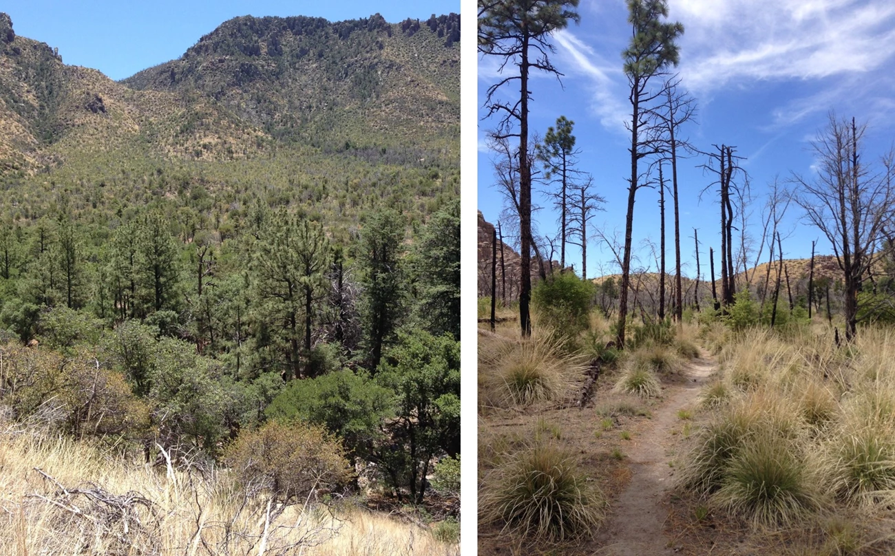
A. Barton
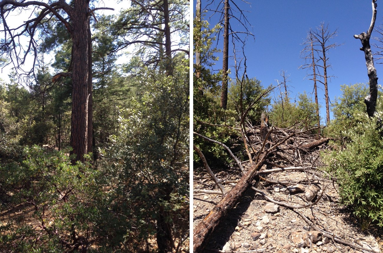
A. Barton
(1) loss of cover,
(2) transition of some forests and woodlands to chaparral,
(3) loss of pines, and
(4) replacement of fire-resistant and fire-sensitive species (pines) by fire-responsive sprouters, seeders, and grasses.
These patterns are seen throughout the park. A hike up the Natural Bridge Trail is revelatory. First you see entire hillsides where nearly all piñon pines, oaks, and junipers were killed above-ground. There, all but the pines have readily regenerated by re-sprouting (Figure 9). Farther along in an open canyon, only remnants remain of a previously-extensive pine-oak forest (Figure 7). Contrast this with the intact pine-oak forest along the Lower Rhyolite Canyon Trail. The Horseshoe Two Fire burned at low severity (Figure 7) there. The slopes around Inspiration Point are also striking. Notice large dead remnants of Arizona pines and Douglas-fir. There is also a rapidly-growing shrub layer of silverleaf oak saplings and point-leaf manzanita (Figure 8). The Horseshoe Two Fire has very likely also had profound impacts on other aspects of the biota. Little is known about changes wildlife, herbaceous plants, and aquatic organisms experienced.
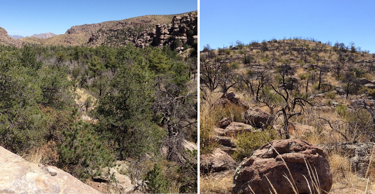
A. Barton
The Future
Fifteen thousand years ago, it was cooler and wetter. The valleys between the Sky Islands were filled with piñon-juniper-oak forests. Desert scrub exists there today. Nature is intrinsically dynamic. We should not expect natural communities to remain static. The rate of change at the hands of humans is unprecedented, though. A century of fire suppression drastically changed the structure of woodlands and forests. The Horseshoe Two Fire is probably the most profound environmental event in the Chiricahua Mountains.What are likely scenarios for the future? Seven years is a relatively short period for long-lived plants, like conifers. Favorable regeneration conditions are possible in the future. Conifers might recolonize communities that are now dominated by oaks and small shrubs. But, intensification of drought and wildfire is projected for the American Southwest. Unless actual future conditions depart from these projections, we would expect fewer pines. Already affected stands would continue to slowly recover. Shrubs have taken hold in parts of the park that burned at high-intensity. Throughout the Southwest, shrubby vegetation regenerates quickly after high-severity fire. Shrubs might be more resilient to contemporary and future climate and fire regimes compared to conifers.
These projections raise important questions for land managers in the Sky Islands.
Is precautionary protection of existing vegetation warranted? For example, combined targeted thinning and prescribed fire could reduce the risk of future wildfires. Many land managers in the Southwest practice a well-established management intervention.
Should land managers consider restoration pilots for conifers? Field experiments focused on pine establishment could explain recent failure of these species. Environmental stresses and the stages of establishment are causing trouble for pines. These experiments could also serve as trials for actual pine restoration. Researchers could assess effective interventions and feasibility. They could even establish initial nuclei for future stands.
These issues beg the larger philosophical question: what is the appropriate role of land managers trying to heal the past damage caused by human civilization on natural ecosystems of the American Southwest?
| PLANT SPECIES | Adaptations & Reponses to Fire |
| TREES | |
| Arziona Madrone (Arbutus arizonica) |
Variable trunk damage Can survive extensive bark and cambium damage Sprouting from the root crown and tree bole |
| Arizona Cypress (Hesperocyparis arizonica) |
Fire-sensitive trunk Serotinous cones |
| Alligator-bark Juniper (Juniperus deppeana) |
Large individuals can survive low-intensity fire Sprouting from root crown, trunk, and branches |
| Arizona Pine (Pinus arizonica) |
Can survive low- and moderate-intensity fire |
| Border Piñon (Pinus discolor) |
Fire sensitive Seeds germinate from seeds cached by amimals Nurse plants facilitate establishment in the open |
| Rocky Mountain Piñon (Pinus edulis) |
Fire-sensitive trunk Seeds germinate from seeds cached by amimals |
| Apache Pine (Pinus englemannii) |
Can survive low- and moderate-intensity fire |
| Chihuahua Pine (Pinus leiophylla) |
Can survive low- and moderate-intensity fire Modest sprouting, mainly in small stems Semi-serotinous cones |
| Douglas-fir (Pseudotsuga menziesii) |
Can survive low-intensity fire; moderate intensity in large trees Susceptible to fire crowning due to low branches |
| Arizona White Oak (Quercus arizonica) |
Large individuals can survive low-intensity fire Sprouting after top-kill |
| Emory Oak (Quercus emoryi) |
Fire-sensitive trunk Sprouting after top-kill |
| Gambel Oak (Quercus gambelii) |
Sprouting after top-kill from root crown and roots Large individuals can survive low-intensity fire |
| Silverleaf Oak (Quercus hypoleucoides) |
Fire-sensitive trunk, but Large individuals can survive low-intensity fire Sprouting after top-kill |
| Southwestern Black Cherry (Prunus serotina var. virens) | Fire-sensitive trunk Dormant seed banks stimulated by fire-created openings |
| White fir (Abies concolor) |
Fire-sensitive trunk |
| SHRUBS | Shrubs exhibit low shoot survival of fire |
| Netleaf Oak (Quercus rugosa) |
Sprouting after top-kill from root crown |
| Toumey Oak (Quercus toumeyi) |
Sprouting after top-kill from root crown |
| Pointleaf Manzanita (Arctostaphylos pungens) |
Obligate seeder Dormant seed banks stimulated by fire Rooting of low branches observed |
| Wright’s Silktassel (Garrya wrightii) |
Sprouting from root crown |
| Catclaw (Acacia greggii) |
Sprouting from root crown |
| California Buckthorn (Frangula californica) |
Sprouting from root crown |
| Skunkbush and (Rhus trilobata) |
Sprouting Possible dormant seed bank |
| Littleleaf Sumac (Rhus microphylla) |
Sprouting Possible dormant seed bank |
| Mesquite (Prosopis glandulosa) |
Sprouting after top-kill from underground stem |
| Fendler’s Ceanothus (Ceanothus fendleri) |
Sprouting after top-kill from root crown Extensive seedling establishment after fire |
| Mountain-mahogany (Cercocarpus montanus) |
Sprouting after top-kill from root crown |
| Schott’s Yucca (Yucca schottii) |
Sprouting after top-kill from roots |
References
Baisan, C.H. and Morino, K.A. 2000. Fire History in Chiricahua National Monument. Final Report to Chiricahua National Monument, National Park Service.
Barton, A.M. 1994. Gradient analysis of relationships among fire, environment, and vegetation in a southwestern USA mountain range. Bulletin of the Torrey Botanical Club 121: 251-265.
Barton, A.M. 1999. Pines versus oaks: effects of fire on the composition of Madrean forests in Arizona. Forest Ecology and Management 120: 143-156.
Barton, A.M. 2002. Intense wildfire in southeastern Arizona: transformation of a Madrean oak–pine forest to oak woodland. Forest Ecology and Management 165: 205-212.
Barton, A.M., Swetnam, T.W., Baisan, C.H., 2001. Arizona pine (Pinus arizonica) stand dynamics: local and regional factors in a fire-prone madrean gallery forest of Southeast Arizona, USA. Landscape Ecology 16: 351-369.
Barton, A.M. and Poulos, H.M. 2018. Pines vs. oaks revisited: conversion of Madrean pine-oak forest to oak shrubland after high-severity wildfire in the Sky Islands of Arizona. Forest Ecology and Management 414: 28-40.
Brown, D.E. 1973. The Natural Vegetative Communities in Arizona. Map. 1:500,000 scale. (Arizona Resources Information Systems, cooperative publication 1). Phoenix, Arizona.
DeBano, L.H., Ffolliott, P.H., Ortega-Rubio, A., Gottfried, G.J., Hamre, R.H., Carleton, B. 1995. Biodiversity and management of the Madrean archipelago: the sky islands of southwestern United States and northwestern Mexico. In, Rocky Mountain Forest and Range Experiment Station, General Technical Report. USDA Forest Service, General Technical Report, RM-GTR-264, Tucson, AZ.
Gebow, B. S. 2005. Chiricahua National Monument Fire Management Plan. US Park Service, Department of the Interior.
Governor's Forest Health Councils, State of Arizona. 2007. The Statewide Strategy for Restoring Arizona's Forests. Aumack, E., Sisk, T., Palumbo, J., editors. Published by Arizona Public Service, Phoenix, AZ.
Kaib, J.M., Baisan, C.H., Swetnam, T.W. 1996. Fire history in the gallery pine-oak forests and adjacent grasslands of the Chiricahua Mountains, Arizona. In: Ffolliott, P.F., DeBano, L.F., Baker, M.B., Gottfried, G.J., Solis-Garza, G., Edminster, C.B., Neary, D.G., Allen, L.S., Hamre, R.H. (Eds.), Effects of Fire on Madrean Province Ecosystems. USDA Forest Service, General Technical Report, RM-GTR-289, Tucson, AZ, pp. 253-264.
Kaib, J.M. 1998. Fire history in riparian pine-oak forests and the intervening desert grasslands of the Southwest Borderlands: a dendrochronological, historical, and cultural inquiry. Masters Thesis, The University of Arizona. 248 pp.
Martinson, E.J., Omi, P.N. 2013. Fuel treatments and fire severity: a meta- analysis. RMRS-RP-103.
Miller, J.D., Thode, A.E. 2007. Quantifying burn severity in a heterogeneous landscape with a relative version of the delta Normalized Burn Ratio (dNBR). Remote Sens. Environ. 109, 66–80.
Minor, J., Falk, D., Barron-Gafford, G. 2017. Fire Severity and Regeneration Strategy Influence Shrub Patch Size and Structure Following Disturbance. Forests 8: 221. 10.3390/f8070221.
Morino, K.A., C.H. Baisan, and T.W. Swetnam. 2000. Historical Fire Regimes in the Chiricahua Mountains, Arizona: An Examination of Fire Along an Elevation Gradient and in Mixed-Conifer Forest. Final Report to Chiricahua National Monument, National Park Service.
O'Connor, C.D., Falk, D.A., Lynch, A.M., Swetnam, T.W., 2014. Fire severity, size, and climate associations diverge from historical precedent along an ecological gradient in the Pinaleno Mountains, Arizona, USA. Forest Ecology and Management 329: 264-278.
Parker, A.J. 1980. The successional status of Cupressus arizonica. Great Basin Naturalist 40: 254-264.
Poulos, H.M., Taylor, A.H., Beaty, R.M. 2007. Environmental controls on dominance and diversity of woody plant species in a Madrean, Sky Island ecosystem, Arizona, USA. Plant Ecology 193: 15-30.
Swetnam, T.W., Baisan, C.H. 1996. Historical fire regime patterns in the southwestern United States since AD 1700. In: Allen, C.D. (Ed.), Fire Effects in Southwestern Forests, Proceedings of the 2nd La Mesa Fire Symposium. USDA Forest Service, General Technical Report, RM-GTR-286, Los Alamos, NM, pp. 11-32.
Swetnam, T.W., Baisan, C.H. 2003. Tree-ring reconstructions of fire and climate history in the Sierra Nevada and southwestern United States. In: Veblen, T.T., Baker, W., Montenegro, G., Swetnam, T.W. (Eds.), Fire and climatic change in temperate ecosystems of the western Americas. Springer, pp. 158-195.
Swetnam, T.W., Baisan, C.H., Kaib, J. 2001. Forest fire histories of the sky islands of La Frontera. In: Webster, G.L., Bahre, C.J. (Eds.), Changing plant life of La Frontera: observations on vegetation in the United States/Mexico borderlands. University of New Mexico Press, Albuquerque, Albuquerque, NM, pp. 95-119.
Wolfson, B.S. The Horseshoe 2 Fire: 6 years post-fire, a Story Map. https://www.arcgis.com/apps/MapJournal/index.html?appid=d15989a5d1de4d449897c5b89e15e50d. Southwest Fire Science Consortium. [Accessed March 1, 2018]
Youberg, A., Neary, D.G., Koestner, K.A., Koestner, P.E., 2013. Post-wildfire erosion in the Chiricahua Mountains. In: Gottfried, G.J., Ffolliott, P.F., Gebow, B.S., Eskew, L.G., Collins, L.C. (Eds.) Merging science and management in a rapidly changing world: Biodiversity and management of the Madrean Archipelago III. USDA Forest Service, Rocky Mountain Research Station, General Technical Report, RMRS-P-67, Tucson, AZ, pp. 357-361.
