Last updated: December 28, 2022
Article
Stratotype Inventory—Glacier National Park, Montana
Introduction
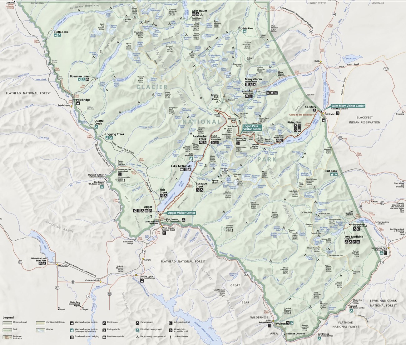
Glacier National Park (GLAC), located in Flathead and Glacier counties, northern Montana, was established May 11, 1910 and is renowned for its spectacular glacial landscapes, sparkling lakes, and a diverse ecoregion home to an array of plant and animal species. The National Historic Landmark Going-to-the-Sun Road bisects the park and provides breathtaking alpine views and access to remote wild land enjoyed by more than 2 million visitors per year (Anderson 2017). GLAC encompasses 410,078 hectares (1,013,324 acres) of land. It was authorized as part of the Waterton-Glacier International Peace Park in 1932, designated a Biosphere Reserve in 1976, and designated a World Heritage Site in 1995 (Anderson 2017).
NPS image.
Significance and Geologic Resource Values
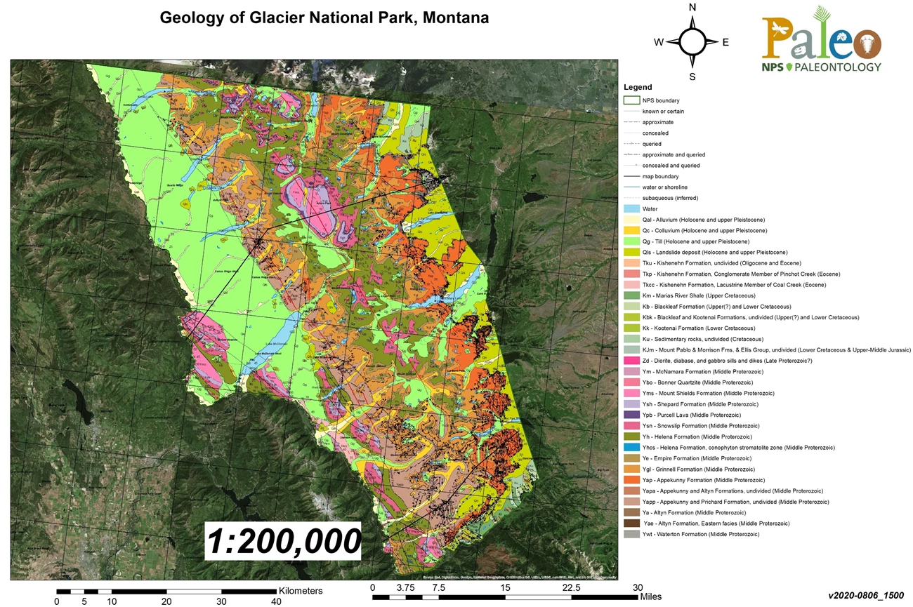
As the name suggests, GLAC contains some of the most spectacular glacial geomorphology on the planet. The story of GLAC involves a complex interplay of geology, water, ice, tectonic forces, and climate. Geological processes established the groundwork that initiated complex responses that led to rock formations, mountains and valleys, waterfalls and lakes (Thornberry-Ehrlich 2004). Compressive tectonic forces along the Lewis Overthrust fault have uplifted older rocks on top of younger ones, with ancient sea beds forming mountainous regions. Subsequent erosion due to streams and glaciers has shaped the landscape visible today. Park stewardship and protection of the architectural elegance of GLAC has become a concern as human influence has noticeably modified its geologic system, and glacial retreat has rapidly increased since the mid-1800s.
NPS image.
Stratotypes in Glacier National Park
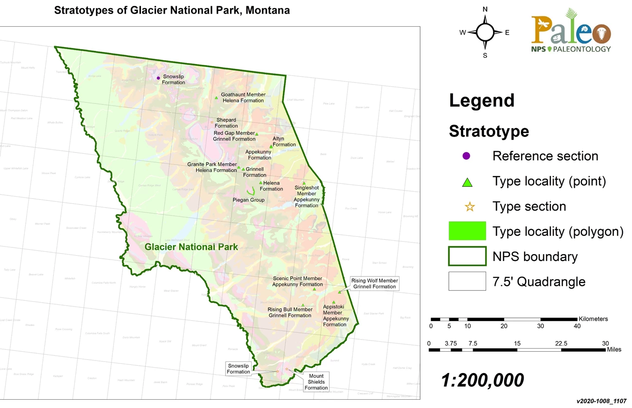
At the time of the writing of this report, Glacier National Park is known to contain seventeen stratotype designations, all of which are part of the Mesoproterozoic Belt Supergroup (~1.5–1.25 billion years ago). These stratotypes can be broken down into two type sections, fourteen type localities, and one reference section (Figure 9; Table below).
| Unit Name (map symbol) | Reference | Stratotype Location | Age |
|---|
Geologic Time Scale
Location Map
NPS image.
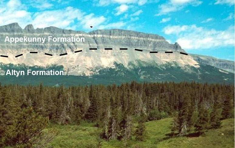
The Mesoproterozoic Altyn Formation occurs only on the east side of GLAC and was named by Willis (1902) for its type locality in the basal cliffs at the foot of Apikuni Mountain north of Altyn in Swiftcurrent Valley (Figures 9 and 10; Table 1). Type locality exposures are approximately 244 m (800 ft) thick (Willis 1902). Originally characterized as a limestone unit, it was later described by Pratt (2017) as consisting of sandy grainstone, intraclastic rudstone, stromatolite patch reefs, laminated silty mudstone, and oolite.
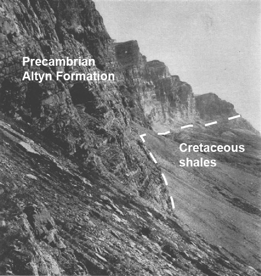
Figure modified from Willis (1902: Figure 2).
The Mesoproterozoic Appekunny Formation was originally named the Appekunny argillite by Willis (1902) after notable exposures in the northeastern spur of Appekunny Mountain, GLAC. Fenton and Fenton (1937) later designated these ~183 m (600 ft)-thick cliff exposures as the type locality for the formation (Figure 9; Table 1). The Appekunny Formation is characterized as a remarkably uniform succession of laminated mudstone, argillaceous siltstone, and very fine-grained sandstone, with an upper part that consists of laminated claystone, siltstone, and intraclastic siltstone (Fenton and Fenton 1937; Pratt 2017). Common sedimentary structures include ripple cross-lamination, low-relief hummocky cross-stratification, mud cracks, and soft-sediment deformation features (Willis 1902; Fenton and Fenton 1937; Pratt 2017).
The Singleshot Member of the Appekunny Formation was named by Fenton and Fenton (1931, 1937) after its type locality at Singleshot Mountain near St. Mary Lake, GLAC (Figures 9 and 11; Table 1). The unit is described as a 91–122 m (300–400 ft) thick succession of argillites and quartzites interbedded with siliceous dolomite and dolomitic sandstone that contains abundant mud cracks, ripple marks, and abundant mud breccias (Fenton and Fenton 1937). Besides the type locality, the Singleshot Member has notable exposures on the western slope of Goat Haunt Mountain and on the northern face of Gable Mountain, GLAC (Fenton and Fenton 1937).
Annotated USGS photo.
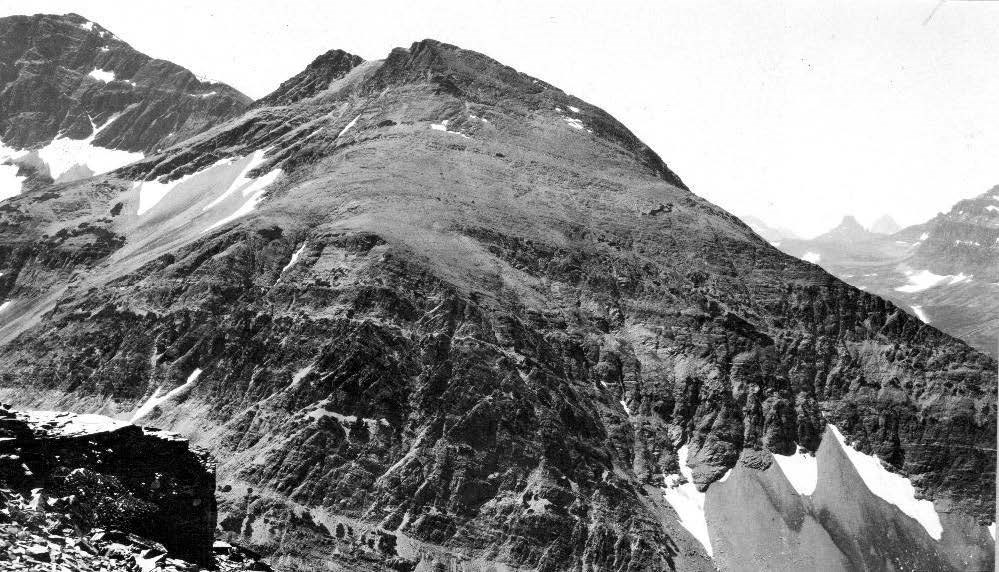
The Appistoki Member of the Appekunny Formation was designated by Fenton and Fenton (1931, 1937) after type locality exposures at Appistoki Peak, near Two Medicine Lake, GLAC (Figures 9 and 12; Table 1). The Appistoki Member is characterized as gray, green, olive-brown, and rusty-gray argillites that are interbedded with stratified green, white, or pink quartzites (Fenton and Fenton 1937). Common sedimentary features include pebble breccias, mud cracks, and abundant ripple marks. In some layers rain and sleet prints are present (Fenton and Fenton 1937). In the region of Two Medicine Lake, the Appistoki Member consists primarily of finely laminated argillites with pebble breccias that consist of small blue and green pebbles embedded in a darker-green, gritty matrix (Fenton and Fenton 1937).
USGS photo.
The Scenic Point Member of the Appekunny Formation was named by Fenton and Fenton (1937) for its type locality exposures at Scenic Point, overlooking Two Medicine Valley, GLAC (Figure 9; Table 1). Fenton and Fenton (1937) describe the type locality exposures as consisting of micaceous to earthy, green, red, buff, and brown argillites that contain mud cracks, with interbedded coarse, friable sandstones. In the region of Two Medicine Valley, the Scenic Point Member forms cliffs at Twin Falls and below Upper Two Medicine Lake. Thick ledges consisting of the member are exposed along the trail to Cobalt Lake. At Many Glacier, the member is characterized as thickly bedded, coarsely mud-cracked argillites that are green or purplish-green, with a few dull, dark red interbeds that form resistant ledges near lakes and streams (Fenton and Fenton 1937).
The Mesoproterozoic Grinnell Formation was originally named the Grinnell argillite by Willis (1902) after the type locality occurrence at Mount Grinnell where the unit is 550 m (1,800 ft) thick at the head of Swiftcurrent Valley, GLAC (Figure 9; Table 1). Willis (1902) states that the Grinnell Formation is also well-exposed along the eastern side of Appekunny and Robertson Mountains. Stratigraphically, the Grinnell Formation conformably underlies the Empire Formation and overlies the Appekunny Formation (Figure 13). The unit is comprised of strikingly red- to maroon-colored strata, consisting of laminated mudstone and claystone with sporadic beds of white, cross-laminated sandstone or quartzite (Figures 14A and 14B; Pratt 2017). Common sedimentary structures include ripple marks and mud cracks.
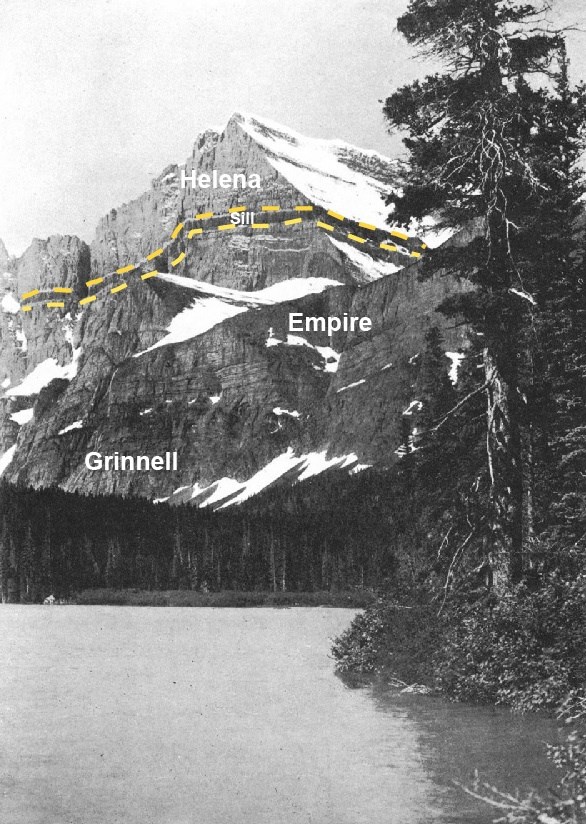
Figure 13. View of Mount Gould from the south fork of Swiftcurrent Lake, looking southwest, GLAC. The upper cliffs are comprised of the Helena and Empire Formations, with lower cliffs consisting of the Grinnell Formation; dark band outlined by orange dashed lines consists of intrusive diorite sill. Thickness of rock exposures from lake to summit is 1,423 m (4,670 ft).
Figure modified from Willis (1902: Plate 46).

Figure 14. Grinnell Formation in GLAC. (A) Exposures along the Grinnell Glacier trail, showing red mudstone and interbedded white quartzite. Black band halfway up the exposure is diabase sill with contact-metamorphosed carbonate on either side. (B) Baring Creek exposure showing oblique view of red mudstone with interbedded thin lenses of quartzite containing blocky claystone intraclasts, capped by a bed of cross-laminated quartzite.
Figure from Pratt (2017: Figure 7).
The Rising Wolf Member of the Grinnell Formation was named by Fenton and Fenton (1937) after its type locality exposures on the southern slopes of Rising Wolf Mountain, GLAC (Figure 9; Table 1). Fenton and Fenton (1937) designated the Rising Wolf Member as the basal member of the formation and characterized the unit as a series of alternating white and pink quartzites interbedded with dark red argillites. Common sedimentary features of the member include symmetrical and asymmetrical ripple marks, mud cracks, cross-bedding, mud breccias, and mud balls (Fenton and Fenton 1937).
The Red Gap Member of the Grinnell Formation was originally designated by Fenton and Fenton (1931, 1937) for exposures in northwest GLAC. Fenton and Fenton (1937) describe the type locality as the mountain (now considered to be Crowfeet Mountain) between Red Gap and Ptarmigan Wall, GLAC (Figure 9; Table 1). Type locality exposures consist of fine-grained, red argillites that occur in thin to thick beds and contain ripple marks and abundant mud cracks (Fenton and Fenton 1937). The member is well-exposed in the Lewis Range north of Many Glacier and is recognizable for its thick beds of red argillite with flat mud-crack polygons (Fenton and Fenton 1937).
The Rising Bull Member of the Grinnell Formation was named by Fenton and Fenton (1931, 1937) for its type locality exposures in the upper cliffs of Mount Rockwell (Rising Bull of the Blackfeet), south of Upper Two Medicine Lake, GLAC (Figure 9; Table 1). Type locality exposures are approximately 183 m (600 ft) thick and consist of alternating white and pink quartzites, red argillites, and mud breccias (Fenton and Fenton 1937). Sedimentary features of the member include ripple marks, cross-bedding, mud cracks, and mud balls (Fenton and Fenton 1937).
Annotated USGS photo.
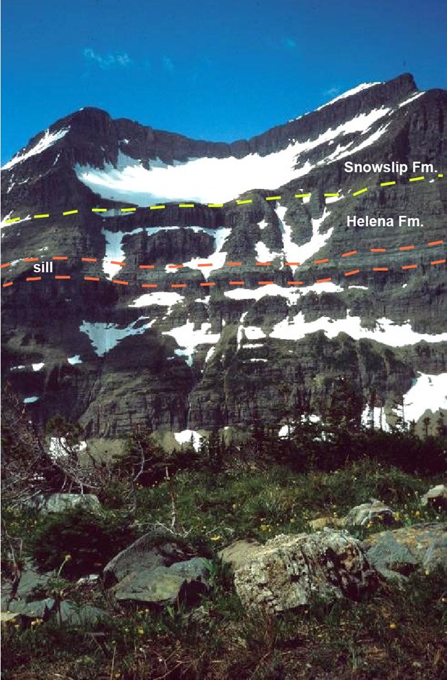
The Mesoproterozoic Piegan Group of the Belt Supergroup was originally designated the “Siyeh or Wallace group” by Clapp (1932) and redesignated by Fenton and Fenton (1937) for its type locality at Piegan Mountain, GLAC (Figures 9 and 15; Table 1). Fenton and Fenton (1937) chose the type locality at Piegan Mountain for its excellent exposures of the Helena Formation. Other notable exposures for the Piegan Group occur at Mounts Gould, Wilbur, Cleveland, and Lineham of the Glacier–Waterton Lakes region (Fenton and Fenton 1937). The group is characterized as consisting of limestones, dolomites, and dominantly argillaceous clastics that stratigraphically occur between the Missoula and Ravalli groups (Fenton and Fenton 1937). The group is also known for displaying exceptionally preserved stromatolites.
The Mesoproterozoic Helena Formation (formerly known as the Siyeh Formation) was named by Walcott (1899) for the occurrence of thick limestone exposures in the upper part of the city of Helena and on the hill slopes to the east, with an estimated thickness of 732 m (2,400 ft). The type locality assigned to the superseded Siyeh Formation by Willis (1902) at the head of Canyon Creek, GLAC is included in this inventory for the Helena Formation (Figure 9; Table 1). The Helena Formation is characterized as dolomite and limestone that weathers gray or blue-gray, some siliceous limestone oolite, and interbedded gray siliceous shale beds (Figure 16A; Walcott 1899; Knopf 1950; Pratt 2017). Particularly notable features are abundant molar-tooth structures (Figure 16B) and 3 m (10 ft)-thick Collenia stromatolites that occur at intervals throughout the formation (Knopf 1950; Pratt 2017).
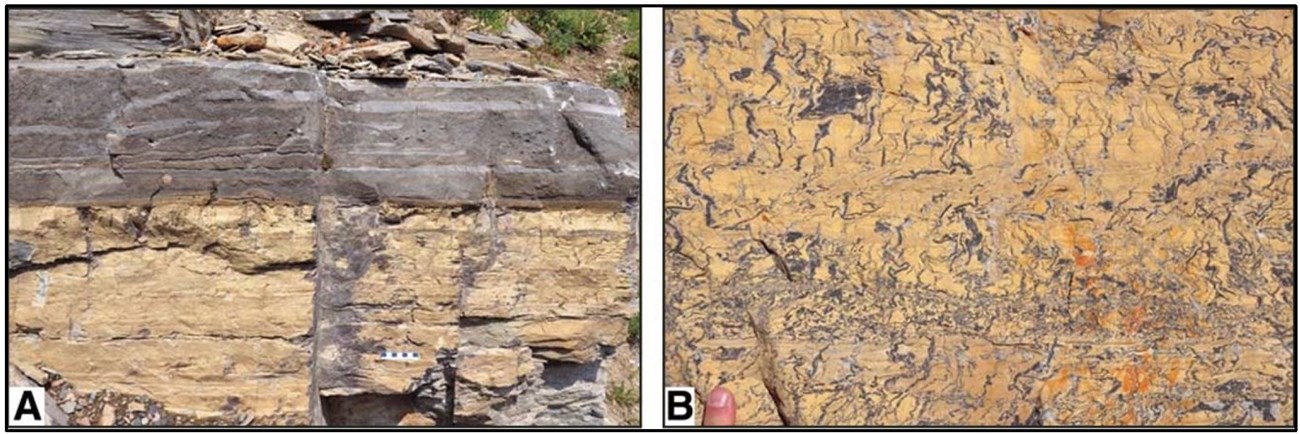
Figure 16. Rocks of the Helena Formation. (A) Laminated and thin-bedded dolomitic lime mudstone sharply overlain by oolite containing mudstone rafts and intraclasts; roadcut on Going-to-the-Sun Road between Lunch Creek and Logan Pass, GLAC. (B) Laminated dolomitic lime mudstone riddled with molar-tooth structures, block at side of Highway 6 north of entrance to Waterton Lakes National Park.
Figure from Pratt (2017: Figure 8).
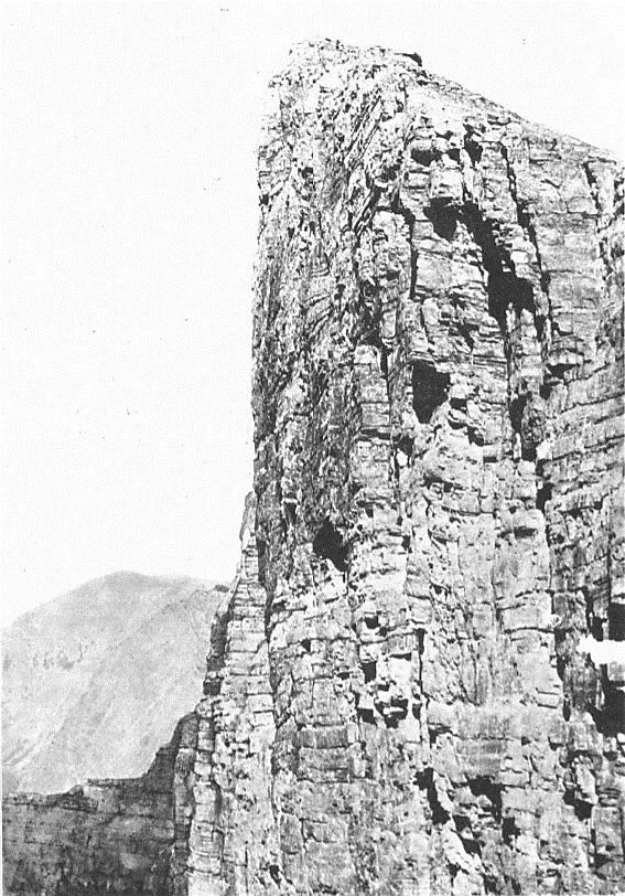
Figure from Willis (1902: Plate 49).
The Goathaunt Member of the Helena Formation was designated by Fenton and Fenton (1931, 1937) after its type locality in the south wall of the cirque between Mount Goat Haunt and Mount Cleveland, GLAC (Figures 9 and 17; Table 1). The Goathaunt Member is characterized as limestones, dolomites, oolites, dolomitic sandstones, and argillites that are generally thick-bedded and dark gray (Fenton and Fenton 1937). Common sedimentary structures of the unit include mud breccias, mud cracks, and ripple marks. Near Piegan and Swiftcurrent Passes, the member contains abundant molar-tooth structures (Fenton and Fenton 1937). Stromatolites are abundant throughout the upper half of the member, and exposures on Going-to-the-Sun and Cataract Mountains contain colonies of Collenia willisii that reach 0.9–1.5 m (3–5 ft) in diameter (Fenton and Fenton 1937).
The Granite Park Member of the Helena Formation was named by Fenton and Fenton (1931, 1937) for its type locality in the cliffs of the Continental Divide southeast from Granite Park, GLAC, where the strata are crossed by a trail to the dike above Grinnell Glacier (Figure 9; Table 1). Type locality exposures of the member are approximately 87 m (285 ft) thick and consist of dolomites, argillites, and thin quartzites with thin strata of oolite, sandstone, and mud breccia (Fenton and Fenton 1937). Flattened stromatolite colonies of Collenia willisii are found in several intervals at the type locality and measure 0.3–1.2 m (1–4 ft) in diameter (Fenton and Fenton 1937). The Granite Park Member contains abundant stromatolites at other locations in GLAC that include exposures along Going-to-the-Sun Highway, Hole-in-the-Wall cirque, and Flattop Mountain (Figure 18; Fenton and Fenton 1937).
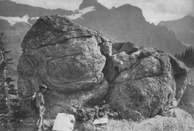
Figure from Fenton and Fenton (1931: Plate X).
The Mesoproterozoic Snowslip Formation was designated by Childers (1963) after the type section occurrence on the ridge between Snowslip Mountain and Mount Shields, GLAC (Figure 9; Table 1). Measured on the north spur of Snowslip Mountain (latitude 48°16’30” N., longitude 113°31’ W.), the type section exposure is approximately 490 m (1,600 ft) thick and consists predominantly of quartzites and argillites, with a distinct basal section of sandy argillite breccias (Childers 1963). Conspicuous type section features include ripple marks, mud cracks, cross-bedding, and the occurrence of a stromatolite zone in the lower part of the unit, which Rezak (1957) named the Collenia undosa Zone 2 (Childers 1963). Stratigraphically, the formation conformably overlies the Helena (formerly Siyeh) Formation and is conformably overlain by the Shepard Formation. Since the type section of the Snowslip Formation does not contain the Purcell Lava, Whipple and Johnson (1988) designated a reference section containing the lava that is accessible and well-exposed in the northern part of GLAC, just east of Boulder Pass, in the east-facing wall of the Hole-in-the-Wall cirque (Figures 9 and 19; Table 1). The reference section contains six informal members that are designated, from oldest to youngest, 1 through 6; the uppermost member, 6, encloses the Purcell Lava and a diabase sill (Figure 21; Whipple and Johnson 1988). Common sedimentary structures of the reference section include fining-upward sequences, desiccation cracks, cross-bedding, ripple marks, and mud chips (Figure 20; Whipple and Johnson 1988). Upper and lower contacts of the formation are exposed, showing the Snowslip Formation to be conformable with adjacent stratigraphic units. The total thickness of the Snowslip, the Purcell Lava, and enclosed diabase sill is 358 m (1,173 ft).
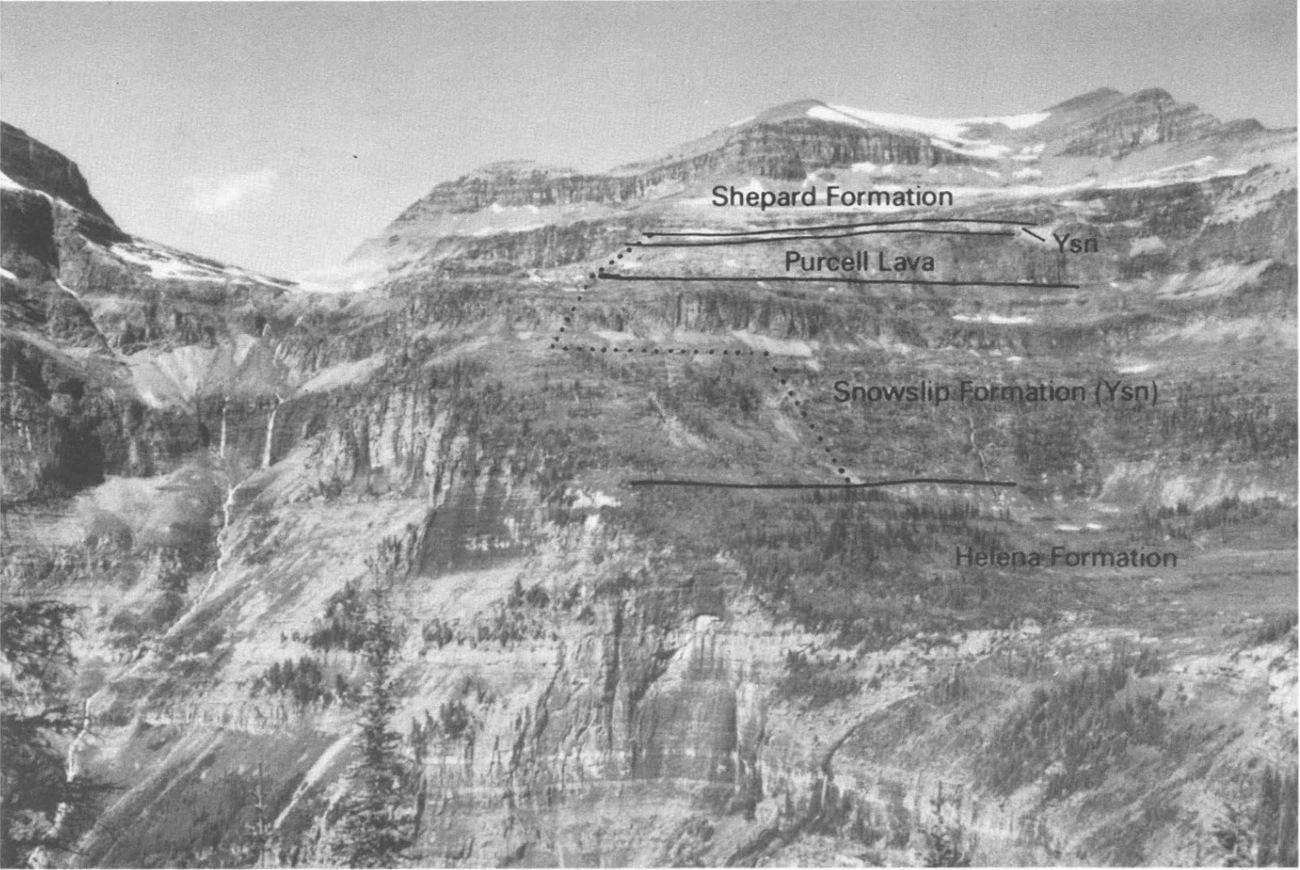
Figure from Whipple and Johnson (1988: Figure 4).
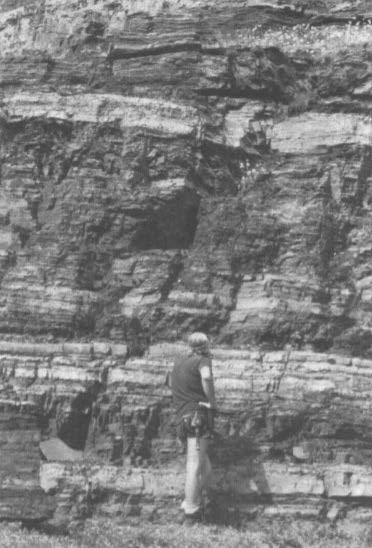
Figure from Whipple and Johnson (1988: Figure 9).
The Mesoproterozoic Shepard Formation was originally named by Willis (1902) after exposures that form the crest of the Lewis Range in the vicinity of Mount Cleveland and Shepard Glacier between Belly River and Flattop Mountain, GLAC. The unit is described as containing gray or brown argillaceous and siliceous dolomites, magnesian limestones, and interbedded greenish-white magnesian quartzites (Willis 1902; Fenton and Fenton 1937). Characteristic sedimentary features include ripple marks, mud cracks, channel fillings, and edgewise mud breccias. Fenton and Fenton (1937) later designated the type locality as the cliffs of the Lewis Range near Shepard Glacier. Well-exposed sections occur on Mount Carthew, Bounder, and Swiftcurrent peaks, and mountains near Logan Pass, as well as in the valley of the Middle Fork of the Flathead River (Fenton and Fenton 1937).
The Mesoproterozoic Mount Shields Formation was named by Childers (1963) to describe exposures consisting of thin-bedded bright-red and maroon siltstones, sandstones, quartzites, and shales in the region of Mount Shields, GLAC. Childers (1963) designated the type section along the ridge between Mount Shields and Blacktail Mountain (Fig. 2; PL 1), latitude 48°17’ N., longitude 113°29’ W. Measured type section thickness is approximately 777.5 m (2,551 ft). Common sedimentary features that occur throughout most of the formation include black hematite staining, salt casts, oscillation ripple bedding, and mud cracks (Childers 1963). Stratigraphically, the Mount Shields Formation appears to be conformable with the overlying Red Plume Quartzite and underlying Shepard Formation (Childers 1963).
In addition to the designated stratotypes located within GLAC boundaries, a list of stratotypes located within 48 km (30 mi) of park boundaries is included here for reference. These nearby stratotypes include:
- Proterozoic-age Roosville, Mount Rowe, and Kintla Members of the Miller Peak Formation (type localities)
- Jurassic Swift Formation (type locality)
- Cretaceous Cut Bank Member of the Kootenai Formation (reference section)
Type Section Inventory Report—Rocky Mountain Inventory & Monitoring Network
The information on this page is excerpted from a report covering six parks within the Rocky Mountain Inventory and Monitoring Network (ROMN):
- Florissant Fossil Beds National Monument, Colorado
- Glacier National Park, Montana
- Grant-Kohrs Ranch National Historic Site, Montana
- Great Sand Dunes National Park and Preserve, Colorado
- Little Bighorn Battlefield National Monument, Montana
- Rocky Mountain National Park, Colorado
The full Network report is available in digital format from https://irma.nps.gov/DataStore/Reference/Profile/2283702
Please cite this publication as:
- Henderson, T., V. L. Santucci, T. Connors, and J. S. Tweet. 2020. National Park Service geologic type section inventory: Rocky Mountain Inventory & Monitoring Network. Natural Resource Report NPS/ROMN/NRR—2020/2215. National Park Service, Fort Collins, Colorado.
Geodiversity Atlas—Rocky Mountain Network Index
Leave No Trace—Protect Type Sections for Science

Many type sections and paleontological sites are vunerable to damage from careless visitation and over-use. Be sure to practice Leave No Trace princples whenever you are in the outdoors. Of particular importance at geoheritage sites is to:
-
Travel and camp on durable surfaces, and
-
Leave what you find.
If you see signs of vandalism or someone acting inappropriately during your visit to a park site, please contact a ranger at the park or make a report through NPS Investigative Services.
Related Links
- Glacier National Park, Montana—[Geodiversity Atlas] [Park Home]
- Geologic Time Scale
- America's Geoheritage
- NPS Paleontological Resource Inventory
- NPS Geologic Resources Inventory
- NPS Geodiversity Atlas
