An official website of the United States government
Here's how you know
Official websites use .gov A
.gov website belongs to an official government
organization in the United States.
Secure .gov websites use HTTPS A
lock (
) or https:// means you've safely connected to
the .gov website. Share sensitive information only on official,
secure websites.
Whiskeytown National Recreation Area has dozens of miles of trails for hiking, trail running, mountain biking, and horseback riding. A rugged canyon, waterfalls, historic mining features, post-fire ecology, and of course Whiskeytown Lake can all be enjoyed on specific trails.
Please be advised that triple digit heat is common between Memorial Day and Labor Day. If you plan on getting out on the trails during this time, hike in the early morning. No matter what time of year you hike, always bring lots of water and let someone know where you are going. Finally, be sure to lock your vehicle, keep the interior looking clean and simple, and take your valuables with you. See more hiking safety tips below and happy trailing!
Our trails are broken into three categories so that you can find the perfect trail for your skill level, time limit, and interest. Below you will find the trail distance, elevation gain, and a quick description for each of our open trails. If you are still unsure of what trail is right for you, a park ranger will be happy to point you in the right direction!
Easy Hikes
This trails are less than 3 miles long and have little to no elevation gain. They are perfect for beginner hikers, people with limited time, or those who want an easy but rewarding hike!
Distance: 1.2 miles (one way) Elevation Gain: no significant elevation gain
Features
•The trail is mostly level, looping through the "frontcountry" and backfield of Tower House Historic District. The trail goes past Levi Tower's grave.
•The first 0.2 miles are a paved, self-guiding interpretive trail with exhibits that explain the history of the area.
Directions
Follow Highway 299 west to the Tower House Historic District parking lot. At the end of the parking lot by the bulletin board, follow the paved trail to the footbridge over Clear Creek and turn left after crossing. Cross the next bridge and turn right at the trailhead and follow a wide, sandy path along Willow Creek.
The first part of the trail passes behind the historic Camden House and leads you to the picket-fenced gravesite of Levi Tower. Turn to the left just past the gravesite and follow the old Camden Water Ditch behind the barn and along an old road. Follow the road back along Mill Creek, past the site of the Camden sawmill and the Tenant Farmhouse built in 1913 to return to the parking area.
Features
•Most level trail that parallels the historic water ditch constructed by Charles Camden
•Historic features can be spotted all along the trail
Restrictions
No bicycles or horses.
Directions
From Highway 299, turn onto Crystal Creek Road. Follow the road just 100 meters up to the first gravel pullout on the left. This is the trailhead for Crystal Creek Water Ditch Trail. Be sure and lock your vehicle and take your valuables with you. Please display your entrance pass on your dashboard.
Description
From the trailhead, take the short stairway down to the water ditch. The trail is flat and parallels this historic water ditch the entire rest of the way. At the bottom of the stone stairway, you can view the remnants of the cleanout shed. While the wooden components of this structure were unfortunately burned in the Carr Fire in 2018, you can still see the cement foundations. Reconstruction of this structure and restoration of the mechanism is planned in the near future. Charles Camden’s daughter, Grace, had the cleanout shed built in 1913. It featured an ingenious water-powered rotary rake that removed pinecones, leaves and other debris from the flowing water before it entered what was a large wooden flume crossing Willow Creek.
About 200 yards from the cleanout shed is the first of seven drainage crossovers, or flumes, that allow seasonal runoff from small gullies to cross, but not flood, the ditch. The tumbling of Crystal Creek can be heard and seen all along the trail since the Carr Fire burned most of the previously dense vegetation. Various stone retaining walls support the ditch along the way. You come to a section of trail where the hillside is too steep to support a ditch, even with retaining walls, so a 250-foot long narrow boardwalk and flume was built. The boardwalk rests about 25 feet above the creek and may be challenging to those who have a fear of heights.
The trail ends at the intake and coffer dam which historically channeled part of the creek’s flow into this historic waterway. When ready, turnaround and follow the trail back to the trailhead.
Distance: 0.4 miles (one way) Elevation Gain: no significant elevation gain
Features
•Beautiful conifers and lots of shade along this trail
•The picturesque Crystal Creek Falls casade marks the end of the trail
•The natural shaded pool at the base of the cascade is a popular spot for wading and swimming.
Directions
From Highway 299 on the western section of the park, follow Crystal Creek Road for two miles and then turn left into the Crystal Creek Falls trailhead and parking lot. A vault toilet is available at the parking lot.
Description
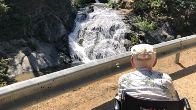
Walk the flat, wide, paved trail behind the access gate for about 1/3 mile until you reach a picnic and barbecue area. Crystal Creek Falls, a two-tiered cascade, is immediately ahead of you. While a good view of the waterfall can be enjoyed from the pavement, an informal dirt trail leads down to the base of the cascade. With significant shade, this area is popular for water play on hot summer days. Behind the small cement building, an informal, unmaintained trail leads to the upper falls; use caution if you choose to walk this steep and rocky route.
As you look at Crystal Creek Falls, you will see a small concrete structure on the right. This building houses an overflow valve for the Trinity Division Tunnel, an 11-mile tunnel that moves water from the Trinity River watershed into the Sacramento River watershed via the Judge Francis Carr Powerhouse and Whiskeytown Lake. The valve is used on occasion when letting water out through Carr Powerhouse is not an option. The excess water from the tunnel then spills into Crystal Creek.
When the overflow structure was built, the Bureau of Reclamation slightly rerouted Crystal Creek. The creek was moved about 50 feet to the left to make a shortcut over the creek, creating this picturesque waterfall. This makes Crystal Creek the only “man-made” waterfall in the park.
Distance: 0.25 miles (one way) Elevation Gain: no significant elevation gain
Features
•Trail located at Horse Camp on Paige Bar Road
•Paved, mostly level trail to Guardian Rock Vista; view of rugged Clear Creek Canyon from the vista
Directions
Starting at the Whiskeytown visitor center, drive south on Kennedy Memorial Drive for 1.6 miles. At the fork in the road, go straight ahead to Paige Bar Road. Continue south past the Whiskeytown Cemetery. The road forks again; take the dirt road to the left that leads to Shasta and Igo. After about 1/3 mile, you will see Horse Camp. The trailhead is just past site #2 on the right hand side of the road, across from the bathroom. The campground is currently closed.
Distance: 2.75 miles (one way) Elevation Gain: 40 ft
Features
•The only trail in the park right along the lake
•Mostly level trail paralleling the northwestern shore of Whiskeytown Lake
•Good birding and fishing opportunities on quiet coves
•Trail mostly travels on top of a historic water ditch dating from the California Gold Rush era
Directions
As you enter Oak Bottom Campground from Highway 299, you will find the trailhead on your right at the pullout with the large bulletin board.
Description
Oak Bottom Water Ditch Trail is a mostly flat trail that parallels the western arm of Whiskeytown Lake from the Oak Bottom area to the Judge Francis Carr Powerhouse area. Because it is the only trail in the national recreation area that goes directly along the lakeshore, it is the park’s best trail for birding. Bald eagle, osprey, green heron, bufflehead duck, American coot, Canadian geese, mallard, and other species that rely on the lake for their survival can sometimes be seen or heard from the trail.
The trail lies directly on top of a historic water ditch. Why was a water ditch built next to a lake? It wasn’t! The water ditch was built 100 years before Whiskeytown Lake existed, when the area was a valley with Clear Creek flowing through it. Historically, Oak Bottom Water Ditch was more commonly known by two other names, Clear Creek Canal and Great Water Ditch (“canal” and “water ditch” are two words that describe the same thing). The water ditch loosely paralleled Clear Creek for 41 miles, bringing water all the way down to the mining community of Ono, south and east of present-day Whiskeytown National Recreation Area.
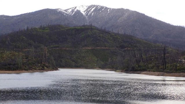
Along Oak Bottom Water Ditch Trail, you can see mountains across the lake. Shasta Bally is the highest mountain in the park and is the mountain you’ll often see with snow on it in winter and spring. It is 6,199 feet above sea level, or about 5,000 feet higher than the water ditch trail. “Bally” is a slight corruption of the Wintu word for mountain; Whiskeytown National Recreation Area is located entirely within the homeland of the Wintu. Scroll down for a springtime photo of Shasta Bally as seen from Oak Bottom Water Ditch Trail.
Moderate Hikes
These trails are anywhere between 1 to 5 miles and have a bit more elevation gain than our easy hikes. These trails are great for people who are looking to work up a sweat and see some beautiful views!
Distance: 1.1 miles (one way) Elevation Gain: 150 ft
Features
•This trail follows a 1950's logging road to Boulder Creek Falls
•You can see lots of abundant vegetation regrowth since the Carr Fire along this trail
Directions
From the Visitor Center, take Highway 299 west for seven miles to the Carr Powerhouse turnoff on the left. Take Carr Powerhouse Road to Mill Creek Road, located on the right ½ mile from the highway. Mill Creek Road is a narrow, winding, steep, gravel road that may be closed after the first winter storms and reopened in late spring. At the road crossing just past the big tank, stay to the right. You will follow Mill Creek Road steadily uphill for 1.3 miles until you reach the trailhead. At the end of the road, you will see a wide spot for parking and the path. Remember to display your entrance pass on your rear view mirror or purchase your pass online. Also be sure and lock your vehicle and carry all valuables with you.
Description
This trail is substantially easier than the trail from South Shore Drive. From the parking area, after a short initial climb, the trail evens out and is a fairly level walk. The trail follows an old logging road. Notice the immense amount of regrowth since the Carr Fire, particularly ponderosa pines. After fording Boulder Creek at the one mile mark, turn right for the final approach to Boulder Creek Falls. Enjoy the view of this waterfall spanning 81 feet.
Geology
Boulder Creek cuts through Copley greenstone, a Devonian metamorphic rock of near-shore oceanic origin formed about 400 million years ago. It ranges in color from dull orange and light brown (weathered) to dark blue-green. Along the trail and in the creek bed you will see numerous areas where the greenstone is capped with granitic boulders. These are debris flows from the Shasta Bally batholith (Cretaceous, 133 million years) that from time to time have washed down the mountain into the creek valley. Several hundred yards above the falls, a particularly good example of this formation may be seen. Across Mill Creek Road at the upper trailhead is a ravine that follows the Hoadley fault through much of the park. The Hoadley is an inactive extensional fault, slightly older than the Shasta Bally Batholith.
Distance: 2.4 miles (one way) Elevation Gain: 900 ft
Features
•Runs from South Shore Drive to the Brandy Creek Falls Trailhead
•Follows the Brandy Creek stream corridor uphill so you can enjoy the sound of mountain water running as you hike
Directions
From Hwy 299, turn left onto JFK Memorial Drive. Drive 4.7 miles and park at the Brandy Creek trailhead on the left, just past the Brandy Creek picnic area turnoff.
Restrictions
Brandy Creek Falls Trail is currently closed, only lower Brandy Creek Trail is open.
Distance: 1.0 mile (one way) Elevation Gain: 167 ft
Features
•Trail begins and ends on Mule Town Road. Combine the trail with the roadway for a two-mile loop
•Travels through open woodland, mixed forest (oak-pine) landscape that has been periodically prescribe burned for several years
Directions
Starting at the Whiskeytown visitor center, take Kennedy Memorial Drive south for two miles to the dam. At the dam, the road forks; take the left fork, which is Paige Bar Road. Follow Paige Bar for two miles, past the Whiskeytown Cemetery, until you reach another fork. Turn left onto the unpaved section of the road which goes to Shasta and Igo. Follow it to Horse Camp, less than one mile.
At Horse Camp, follow the road to the left of the restrooms. The road will fork about 1/2 mile from Horse Camp; Paige Bar Road ends here and Mule Town Road begins. Take the right fork which is signed “Igo” (the left fork will take you to the elementary school in historic Shasta). This section of the road may not be suitable for low clearance vehicles and is recommended for 4-wheel drives. Follow this section of Mule Town Road for about 1/2 mile and park your vehicle at the first trailhead on the left which says, “Buck Hollow/Salt Creek Trail.”
Walk a short distance to reach the connection between the two trails. Take the fork to your left to stay on Buck Hollow; the Salt Creek Loop Trail and the Princess Ditch Trail are currently closed. The path will then wind gently up and down for one mile until it reaches the other side of Mule Town Road. Go back the way that you came.
Distance: 4.5 miles (one way) Elevation Gain: 311 ft
Features
•Partially shaded, mostly flat trail paralleling historic water ditch dating from the California Gold Rush era
•Can see old mining features including the foundation of a large stamp mill
•Access from Mount Shasta Mine Loop Trailhead
•Popular trail for mountain biking and horseback riding; trail connects with Swasey Recreation Area trail
Directions
Starting at the Whiskeytown visitor center, drive south on Kennedy Memorial Drive for 1.6 miles. At the fork in the road, go straight ahead to Paige Bar Road. Follow Paige Bar Road for 1.3 miles. On the left-hand side across the street from Peltier Valley Road, there is a large parking area for the Mount Shasta Mine Loop Trail. The Clear Creek Canal Trail begins on the far north side of the parking lot (the Mount Shasta Mine Loop Trail begins on the opposite side near the bathroom).
Description
The trail parallels Paige Bar Road as it makes its way north. At approximately 0.5 mile, the trail crosses Paige Bar Road and turns back toward the south. Here you can get a good view of Whiskeytown Dam and Clear Creek flowing from the tunnel below the dam.
After an additional 0.75 mile, the trail crosses unpaved Peltier Valley Road. Continue until you reach a gated service road. Go around the gate and follow the service road until you pick up the trail on the left. The trail will again meet Paige Bar Road, just below the Whiskeytown Cemetery. Follow the road to the right for a short way until you pick up the Clear Creek Canal Trail on the left-hand side of the road.
In about 0.25 mile, the trail forks. The left fork is the Mount Shasta Mine Loop Trail. Take the right fork to continue on the Clear Creek Canal Trail. As you near Orofino Creek, the trail takes a steep climb downhill, crosses the creek, climbs uphill and heads west. Once at the top, notice the views of Shasta Bally and Kanaka Peak. The trail then heads downhill and eventually crosses on unpaved section of Paige Bar Road near Horse Camp Primitive Campground. It continues for about 0.75 mile until it ends at Mule Town Road.
History
Originally, the Clear Creek Canal was used by gold miners from the 1860s through the 1880s as a water delivery system to local mines. It was once over 41 miles long, starting near the Tower House Historic District and ending near Lower Springs Road in northwest Redding. Today, the canal is truncated by modern roads and other trails, and the chopped-up sections are known by different names.
Distance: 2.4 miles (one way) Elevation Gain: 300 ft
Features
•Trail goes from the Tower House Historic District parking lot to Carr Powerhouse Road
•Trail passes El Dorado Mine and includes panoramic views of the Tower House Historic District area
Directions
Drive about 8 miles past the visitor center on Highway 299, turn left into the Carr Powerhouse picnic area. You will see the Trailhead as you drive into the parking lot.
Distance: 3.3 miles (one way) Elevation Gain: 793 ft
Features
•Abundant wildflowers in late winter and spring and lots of shade
•Trail can be accessed from Kennedy Memorial Drive just past Whiskeytown Dam or from Brandy Creek Beach parking lot
•Trail parallels the southeast shore of Whiskeytown Lake
Restrictions
No horses or bicycles allowed.
Directions
The trailhead is located on Kennedy Memorial Drive, about a half mile after crossing the Whiskeytown Dam. For a one-way hike, take two vehicles, parking one at the trailhead and drive the other to the opposite end of the trail, located at Brandy Creek Beach lot B, near the restroom.
Description
The trail meanders in and out of small canyons and past numerous interpretive plaques describing plant life along the way. About two miles into the hike, the trail descends to the lakeshore and winds along scenic coves where you may want to go swimming or fishing. The trail follows the lakeshore for about one mile, then gently climbs up a ridge which will descend to the end of the trail at Brandy Creek Beach, Parking Lot B, near the restroom.
Distance: 1.0 mile (one way) Elevation Gain: 252 ft
Features
•Trailhead at Horse Camp, can be made into a 1.5 mile loop by walking back on Paige Bar Road
•At northern end of the trail, gravel has been "injected" into the creek to restore salmon habitat
•First 0.25 miles is easy and paved to the overlook. After the overlook, the trail becomes narrow and rocky and drops down to Guardian Rock gravel bar on Clear Creek (the term "Guardian Rock" refers to a small rock that looks like a face coming out of the gravel bar)
Directions
Starting at the Whiskeytown visitor center, drive south on Kennedy Memorial Drive for 1.6 miles. At the fork in the road, go straight ahead to Paige Bar Road. Continue south past the Whiskeytown Cemetery. The road forks again; take the dirt road to the left that leads to Shasta and Igo. After about 1/3 mile, you will see Horse Camp. The trailhead is just past site #2 on the right hand side of the road, across from the bathroom. The campground is currently closed.
Description
The first ¼ mile is a flat trail made of packed decomposed granite which leads to an overlook of Clear Creek Canyon. Clear Creek is the last major creek that empties into the Sacramento River before Shasta Dam in which Chinook salmon and steelhead trout can spawn. They are returning in increasing numbers to this section of the creek since McCormick-Saeltzer Dam was removed downstream in 2000, opening up 12 miles of spawning habitat. Prior to the dam’s removal, the salmon had almost disappeared from this area.
From the overlook, the tops of Kanaka Peak and South Fork Mountain can be seen. The west side of the creek receives more shade and has moisture-loving trees, such as fir, mixed in with the oak and pine forest. The east and drier side of the creek has a hardier forest composed of oak, grey pine and manzanita.
Get back on the main trail where it intersects with the pathway to the overlook. The trail winds steadily down the rim of the creek canyon for the remainder of its length. Mining remnants can be seen in this area. Look for small terraces once occupied by mining equipment and buildings. A collapsed mining shaft is located on a level area shortly before the next fork in the trail. Stay out and stay alive!
At the fork in the trail, you have the choice of continuing straight ahead or veering off to the left at the sign that says “Guardian Rock.” Take the left fork to the bottom of this trail if you would like the scenic view of Guardian Rock, a large outcropping that looks almost like a finger pointing upwards. This side trail continues upward and meets the main trail.
The next section of trail parallels an old mining road that is supported by an extensive rock wall. Soon you will see the bridge leading to the NEED Camp (closed due to fire damage) and you will come to a crossing with seasonal Orofino Creek. You can return the way that you came, or make a loop back to Horse Camp by following the trail sign which leads to the right. This trail ends at Paige Bar Road, a dirt road which will lead you back to your starting point at Horse Camp. A short ways along the road, you will pass over Orofino Creek near a mineral seep – notice the usually strong odor of sulfur. The pine trees in the area are often occupied by flocks of band-tailed pigeons that drink at the mineral springs.
Horse Camp has a restroom and a faucet with potable water turned on during the warm months of the year.
Distance: 3.1 miles (loop) Elevation Gain: 538 ft
Features
•Loop trail that travels through historic mining area active from the 1850s to 1930s
•Can see evidence of past mining activilty including horizontal and vertical mine shafts, building foundations, and tailing piles
•Popular with mountain bikers and horseback riders
•Located on Paige Bar Road about one-mile below Whiskeytown Dam
Directions
Starting at the Whiskeytown visitor center, drive south on Kennedy Memorial Drive for 1.6 miles to the dam. At the dam, the road forks; take the left fork, which is Paige Bar Road. Follow Paige Bar Road for 1.3 miles. On the left-hand side across the street from Peltier Valley Road, there is a large parking area for the Mount Shasta Mine Loop Trail. The trail begins near the restroom.
Description
Hiking in a counter-clockwise direction, the trail takes you behind Whiskeytown Cemetery, with its unusual grave markers. This cemetery was relocated when the original was flooded with the creation of the lake in 1963. Further on, the trail leads to several intersections with the Clear Creek Canal Trail. This trail follows the footprints of the Great Water Ditch, a 40-mile, man-made ditch. Completed in 1855, the ditch was constructed to supply water to gold mines to the south. At about 1.5 miles, look to the left for the fenced shaft of the Mount Shasta Mine. The original owners sold the mine for $10,000 in 1897, probably to their regret. In the next 14 years, the greatly expanded mine produced $178,000 in minerals from quartz ore. The ore was initially sent to the Keswick smelter for crushing and processing. Around the turn of the century, a steam-powered stamp mill was erected with a capacity of crushing 50 tons of ore each day.
The trail then meanders along Orofino Creek, featuring small pools and waterfalls during winter and spring. The trail makes a left turn at the intersection with the Prospect Trail. It will leave the creek and begin to climb steadily uphill with vistas of the surrounding peaks and the bald, rolling hills in the Igo area. Eventually, you will end up on a former road; go left on the downhill side. Walk along this road for the remainder of your journey, enjoying views of Whiskeytown Lake.
Distance: 1.9 miles (one way) Elevation Gain: 188 ft
Features
•Follows former water ditch and connects to Swasey Recreation Area trails
•Popular with mountain bikers and horseback riders
Directions
Travel west on Placer Road 7.4 miles from the intersection of Buena Ventura Boulevard and Placer Road. Turn right onto Mule Mountain Road and proceed 0.4 of a mile to the parking area at Oak Knoll Trailhead.
Restrictions
High clearnace required for access via Mule Town Road.
Distance: 1.1 miles (one way) Elevation Gain: 99 ft
Directions
Follow Kennedy Memorial Road about 5 miles in past the visitor center. Turn left on the Brandy Creek Road. The Trail head will be roughly 2.5 miles up the road.
Distance: .4 miles (one way) Elevation Gain: 141 ft
Features
•This short trail drops down below the Visitor Center onto Whiskeytown Lake
•The only natural area of the park that did not burn during the Carr Fire
Restrictions
No bicycles or horses allowed.
Directions
The trailhead is easily found at the far end of the Whiskeytown visitor center parking lot, next to the handicap accessible picnic table.
Description
The shady and cool path takes you down to the shoreline of Whiskeytown Lake, where benches provide a quiet spot to enjoy the view. It is also a nice place to go swimming or shore fishing. This is the only trail in the park that was unaffected by the Carr Fire.
Difficult Hikes
These hikes are longer, getting up to around 7 miles one way and have steep elevation gains. These trails are great for people who are serious about hiking and want a longer, more challenging journey!
Distance: 2.8 miles (one way) Elevation Gain: 1,000 ft
Features
•Challenging hike with lots of stream crossings and an abundance of regrowth since the Carr Fire
•Steep trail following 1950's logging roads up the stream corridor
Restrictions
As of 4/2/24 there are several downed trees and erosions from last winter's rain, please hike cautiously.
Directions
Starting at the Whiskeytown Visitor Center, drive 7 miles west on Highway 299. Turn left at Carr Powerhouse, and follow the road all the way past the powerhouse itself. When the paved road ends take a sharp left onto South Shore Drive. Continue 2.7 miles down this narrow, winding, gravel roadway to the trailhead. The trailhead is located on the right side of the road and is identified by a small brown sign. Park across the road, parallel to the road, as close to the edge of the road as possible. The same trailhead can also be approached from Kennedy Memorial Drive. From the Clair A. Hill Whiskeytown Dam, drive west 4.3 miles. Just before the gate at Dry Creek Group Campground, turn left. Follow South Shore Drive 2.7 miles to the trailhead. Remember to display your entrance pass on your rear view mirror or purchase your pass online. Also be sure and lock your vehicle and carry all valuables with you.
Description
The first mile of the trail follows a wide, exposed logging road through a thicket of white leaf manzanita, knobcone pine, redbud, wild grape and poison oak. Near the creek this brushland transitions into a forest of ponderosa pine, Douglas fir, and canyon live oak. While most of the trees and shrubs were killed during the Carr Fire of 2018, notice the substantial amounts of regrowth.
Look for ladybugs in a clearing just before the first creek crossing. Thousands have been seen next to the side of the trail here on sunny days in fall, winter and early spring. The trail follows the creek for the next half mile, crossing Boulder Creek two more time. Bracken and sword ferns abound along the creek. Just past the third crossing, on both sides of the trail, are the deteriorating foundations of a residence last occupied in the 1960s.
A little farther on, the trail forks; take the right fork. You will come to a nice stand of big leaf maples as you approach the final crossing. Approaching the falls, the trail drops down into a cool watershed. The creek leading from the falls is visible, crossing the road. The sign for the short side trail to Boulder Creek Falls will be on your left. Follow the steps up the hill to the base of the waterfall. Relax and enjoy the view!
Boulder Creek Falls is 81 feet tall with an additional 28 feet of cataracts above it. Plants that flourish in this riparian habitat are tiger lily, solomon seal and chain fern. When ready, head back down the trail the way you came.
Geology
Boulder Creek cuts through Copley greenstone, a Devonian metamorphic rock of near-shore oceanic origin formed about 400 million years ago. It ranges in color from dull orange and light brown (weathered) to dark blue-green. Along the trail and in the creek bed you will see numerous areas where the greenstone is capped with granitic boulders. These are debris flows from the Shasta Bally batholith (Cretaceous, 133 million years) that from time to time have washed down the mountain into the creek valley. Several hundred yards above the falls, a particularly good example of this formation may be seen. Across Mill Creek Road at the upper trailhead is a ravine that follows the Hoadley fault through much of the park. The Hoadley is an inactive extensional fault, slightly older than the Shasta Bally Batholith.
Distance: 1.7 miles (one way) Elevation Gain: 1,000 ft
Features
•At 220 feet, Whiskeytown Falls is the longest cascade in the park. At base of waterfall, be sure and walk up the rock staircase to the upper viewing platform
•The trail is steep in spots and mostly follows old logging roads
•There is lots of shade along the trail
•The last 1/4 mile of trail is in a box canyon with a microclimate colder than the surrounding
Restrictions
No bicycles or horses allowed.
Directions
Starting at the Visitor Center, drive west 9 miles along Highway 299 to Crystal Creek Road. Turn left onto Crystal Creek Road and drive for 4 miles until you reach the small, paved parking lot on the left. A vault toilet is located at the trailhead.
Description
The steep, strenuous, and scenic James K. Carr Trail uses mostly former logging roads to get the the tallest waterfall in the park, Whiskeytown Falls, a three-tiered cascade of 220 feet. The trail starts out heading downhill. After crossing over the west fork of Crystal Creek on a small footbridge, the trail begins to climb, sometimes very steeply. Just 0.2 miles before the waterfall is a small picnic area. The trail's final stretch to Whiskeytown Falls is through a narrow canyon. Notice the cooler, shadier climate here. At the base of the falls, feel free to take the stairsteps to the left to the middle falls viewing platform - be sure and use the metal handrails for safety. After relaxing and perhaps having a snack or lunch, return the way you came.
History
Before becoming Whiskeytown National Recreation Area, this area of the park was privately owned by Arthur Coggins, whose logging company selectively removed Douglas fir, ponderosa pine, sugar pine and incense cedar during the 1950s. At this time, the loggers were generally the only people who knew about the falls. Park rangers initially learned about the waterfall in 1967 but kept it quiet. At that time, the park did not have the staff to protect this treasure or the money to construct a trail to the falls. Eventually, these rangers moved on and others who knew about the site passed away. Knowledge of the falls was generally forgotten and only a few residents visited the falls over the years. It was in 2004 that park natural resource managers Russ Weatherbee and Brian Rasmussen found the falls again. Under the leadership of park superintendent Jim Milestone, funding was secured and the formal trail to Whiskeytown Falls was constructed. It formally opened to the public in 2006. The James K. Carr Trail to Whiskeytown Falls is by far the most popular trail in the national recreation area, enjoyed by thousands of visitors each year.
The James K. Carr Trail area burned lightly to moderately during the Carr Fire and the trail was temporarily closed for visitor safety. Both footbridges were replaced and trail repair work was conducted. The trail was reopened on Valentine's Day of 2020.
The trail is named after James K. Carr, a native of Shasta County who was instrumental in the establishment of Whiskeytown National Recreation Area. Carr was a reclamation engineer with an interest in landscape conservation and outdoor recreation. He became Undersecretary of the Interior during the Kennedy administration. Carr, Secretary of the Interior Stewart Udall, U.S. Senator Thomas Kuchel (R-Ca), and others were supportive of park establishment, as were the vast majority of locals within Shasta County. Carr helped push the park concept through Congress as well as locally and on November 8, 1965, the 42,000 acre Whiskeytown National Recreation Area bill was signed into law by U.S. President Lyndon Baines Johnson.
Distance:
From Kanak Peak Trailhead on Peltier Valley Road: 3.5 miles (one way)
From Peltier Bridge Primitive Campground:4.5 miles (one way)
Elevation Gain:
From Kanak Peak Trailhead on Peltier Valley Road: 1,100 ft
From Peltier Bridge Primitive Campground:1,700
Features
Opened for the first time since the Carr Fire Megafire on May 23, 2024!
Directions
Take Highway 299 west of Redding to Kennedy Memorial Drive and turn left where the visitor center is. Continue onto Paige Bar Road and turn right on Peltier Valley Road. Follow the road and park at Peltier Bridge Primitive Campground. If you have a four-wheel-drive vehicle,you can drive another mile on Peltier Valley Road to the Kanaka Peak trailhead.
Distance: 4.8 miles (one way) Elevation Gain: 900 ft
Features
•This trail from Sheep Camp travels up over Papoose Pass and then down the East Fork of Boulder Creek
•Views abound during this Whiskeytown backcountry experience up and down the foothills of Shasta Bally
Directions
Papoose Pass starts right out of the Sheep Camp campground, just to the right of the fire road. The trail is marked with a sign.
Restrictions
As of 4/2/24 there are numerous large trees down across the trail and rockfall over a section of the trail near the pass. Hike cautiously and at your own risk.
Distance: 7.0 miles (one way) Elevation Gain: 2,168 ft
Features
•The gravel roadway starts at the Shasta Divide by the Visitor Center and slowly but steadily climbs 2,000 feet to the top of South Fork Mountain Lookout
•Expansive views of Whiskeytown National Recreation Area, Trinity Alps, Mount Shasta, and Lassen Peak from top on clear day
Directions
The beginning of this route is directly across Highway 299 from the Whiskeytown National Recreation Area visitor center.
Distance: 7.0 miles (one way) Elevation Gain: 2,000 ft
Features:
•Roadway climbs gradually but steadily 2,000 feet up through mixed forest landscape
•Expect lots of downed trees
Directions
Starting at the Visitor Center, drive west 9 miles along Highway 299 to Crystal Creek Road. Turn left onto Crystal Creek Road and drive for 4 miles until you reach the small, paved parking lot on the left. A vault toilet is located at the trailhead.
Distance: 5.5 miles (one way) Elevation Gain: 4,400 ft
Features
•The roadway is very steep and very challenging as a hike
•Towards the top, enjoy expansive views of the national recreation area, Trinity Alps, Mount Shasta, Lassen Peak, and Bally Choop
Directions
Follow Kennedy Memorial Drive for 4.2 miles past the visitor center. Turn left at sign marked Shasta Bally and drive 2.6 miles to Sheep Camp.
Restrictions
This narrow, winding, dirt roadway is not open to vehicular traffic except for park staff and telecommunication contractors.
The only trail right on the lakeshore, this relatively flat trail is 5.5 miles roundtrip. Look for birds on the lake.
Trail Safety Tips
Know your experience level
How often do you hike? What types or terrain and elevation are you used to? It is important to know these things so you can pick the right trail for you. If you are unsure you can always ask one of our Park Rangers for advice!
Plan ahead
Pick a trail suitable for all member's of the hiking party and set pace with the slowest hiker. It is also helpful to check the weather ahead of time so you can bring appropriate materials. Always have an emergency plan, things happen from injuries to loss of cell service, so make sure you have everything you need. Lastly, always let someone outside of the group know where you plan to go and when you plan to return.
Hike smart
Check the parks current conditions before heading out on your hike! Account for the whole time that the hike will take. A lot of our trail distances are one way, so be aware of how far it will be round-trip, you wouldn't want to get stuck out after dark when you weren't prepared for it. Following hiking attitude, yield to uphill hikers, stay to the right, and step to the side to let others pass or if you intend to soak up the views! Take breaks often and drink plenty of water.
Be aware of wildlife
You might see some wildlife while you are out exploring, but don't worry, they want to be left alone just as much as you do. Give all wildlife space and slowly back away if you find yourself in close encounters. By keeping your eyes and ears alert you can stay safe and ensure positive encounters with wildlife here at Whiskeytown.
.")