.gif)

GRTE-N-1
|
Research Report GRTE-N-1
The Elk of Grand Teton and Southern Yellowstone National Parks |

|
THE STUDY AREA
Vegetation
Scientific and common names for plants mentioned in this bulletin listed in Appendix I. These generally follow Davis (1952) or Booth and Wright (1959). Vegetation was classified during field inspections and by analyzing measurements of taxa in representative stands. Measurements were by the author (Appendix II, III, IV) and other workers on the area (Martinka, 1965; Oswald, 1966; Houston, 1967), following Daubenmire (1959), Parker (1951), and Cottam and Curtis (1949).
Figure 1 shows the major vegetation types on the area. Table 2 lists information on their general distribution and the characteristic well as important associated plants for the more representative stands each type. Various mixtures of characteristic and important associated plants occurred in transitional or intermediate successional stages.
Characteristic plants occurred consistently and usually made up the greater portion of the plant crown cover in representative or successionally related stands. Important associated plants for other than forest stands had a crown cover that was slightly less, equal to, greater than characteristic plants. Important associated plants under forest canopies made up one-fourth or more of the ground level crown cover in distinct stands, or had a consistent high frequency of occurrence in successionally related stands.
| Vegetation Type | General Distribution | Characteristic Plants | Associated Plants |
| Bunchgrass—Shrub | Residual and glacial till soils on ridgetops and south, east, and west slopes in valley areas | Bluebunch Wheatgrass—Douglas Rabbitbrush Climax Big Sagebrush—Bitterbrush Stage Needle and Thread—Sandberg Bluegrass Disclimax |
Ricegrass Rubber Rabbitbrush Serviceberry Threetip Sagebrush Idaho Fescue |
| Sagebrush | Glacial outwash plain, stream—cut terraces and alluvial fans | Big Sagebrush Stage Big Sagebrush—Bitterbrush Stage |
Bluebunch Wheatgrass Idaho fescue Balsamroot Lupine Buckwheat Low Sagebrush |
| Valley Meadow | Alluvial soils along water courses below 7500 feet. | Willow—Sedge Stage Tufted Hairgrass—Sedge Stage Sedge—Bluegrass Stage |
Rush Shrubby Cinquefoil Silver Sagebrush Dandelion |
| Floodplain Forest | Stream alluvium up to about 7000 feet. | Narrowleaf Cottonwood Stage Blue Spruce Climax |
Russet Buffaloberry Red Dogwood Willow Thinleaf Alder Balsam Poplar |
| Upland Forest | Glacial till, north and west slopes within the valley and on a variety of substrates and exposures in mountain areas up to 10,000 feet. | Lodgepole Pine Stage Aspen Stage Douglas—Fir Climax Whitebark Pine Climax Englemann Spruce—Subalpine Fir Climax |
Geyer's Sedge Fine grass Arnica Large Huckleberry Dwarf Huckleberry Pachystima Menziesia Spirea |
| Burn | Upland forest stands burned since 1930. | Geyer's Sedge—Lodgepole Pine Disclimax Geyer's Sedge—Subalpine Fir Disclimax | (as in Upland Forest) |
Exceptions to this classification system were the herbland type, where the crown cover of various forbs was usually greater than the two characterizing grasses, and the bunchgrass-shrub type, where big sagebrush/or other shrubs had a greater crown cover than bluebunch wheatgrass on rocky or more mesic sites. Plant species that characterized successionally advanced stands which appeared capable of persisting under the present climate are given a "climax" suffix. Plants characterizing seral vegetation that could ultimately be replaced by climax stands are called a "stage." Plants characterizing stands modified by recent fires or animal use are called a "disclimax." The classification system represents a modification of criteria used by Weaver and Clements (1938) and Daubenmire (1953).
Figures 3 and 4 show what appeared to be the general successional patterns for vegetation in valley and mountain areas. The four types of climax vegetation below 8,500 feet appeared to develop from a variety of seral stands on different sites, exposures, and soils. Successional patterns for subalpine vegetation above 8,500 feet appeared to be comparatively simple. The dual role of mountain brome, slender wheatgrass, and tufted hairgrass in climax stands at high elevations and seral stands at low elevations was evident. Some of associated forbs for the herbland type probably had similar roles. Dual successional roles for tree species have been reported by Daubenmire (1953).
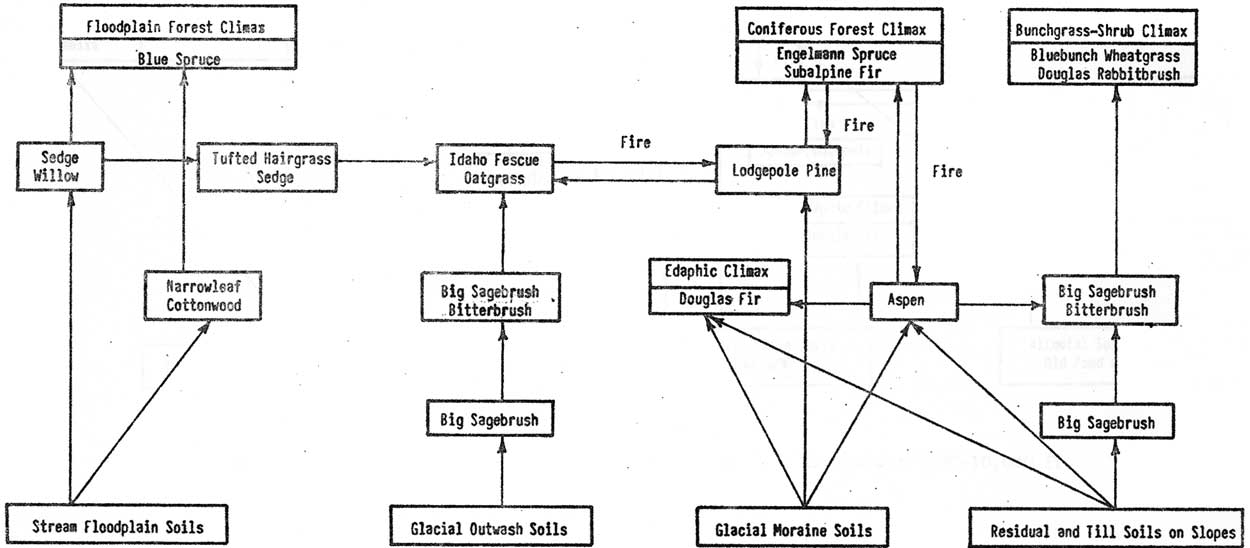 |
| Fig. 3. Plant succession relationships at elevations from 6200-7500 ft. within valley areas. (click on image for an enlargement in a new window) |
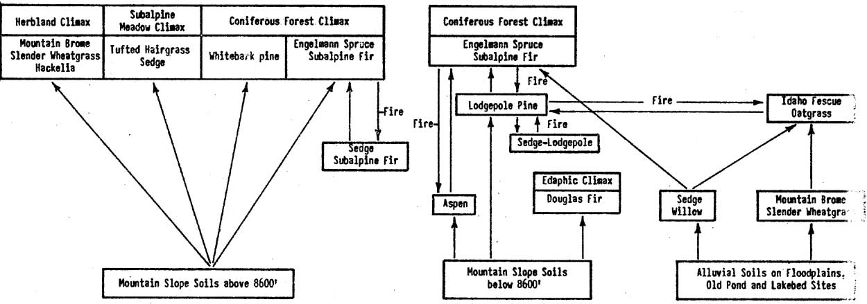 |
| Fig. 4. Plant succession relationships at elevations from about 7000-10,000 ft. within northern mountain areas. (click on image for an enlargement in a new window) |
Host Douglas-fir and whitebark pine stands on the study area were considered edaphic climaxes, but on some more mesic sites they were probably seral to Engelmann spruce and subalpine fir. Ellison (1954) concluded that scattered stands of Engelmann spruce and subalpine fir rocky outcrops in the herbland type were seral to herbland. This was on the Wasatch Plateau in Utah. In this study such stands occurred on rocky sites in both the herbland and subalpine meadow types and frequently contained whitebark pine. They were considered to be edaphic climaxes rather than a seral stage. All lodgepole pine stands were considered seral, but it is recognized that some stands could be considered "fire climaxes" as proposed by Daubenmire (1968). Fire and the biotic influences of wild ungulates in antler rubbing and foraging contributed to maintaining the forest park type.
The classifications of vegetation and judgments of successional patterns made during this study should be considered tentative. Revisions and refinements from more detailed studies are expected. The general appearance of the major vegetation types is shown on Figure 5.
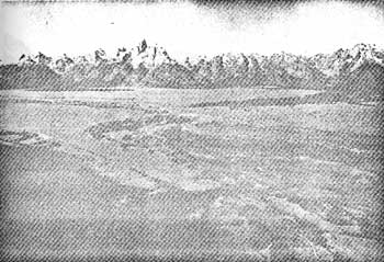 |
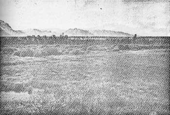
| Fig. 5a. Approximate center of Grand Teton Park showing extensive sagebrush type on the outwash plain, the valley meadow, and bottomland forest types along the Snake River flood plain, and the upland forest type on glacial moraine sites. |
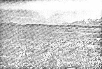 |
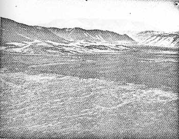
| Fig. 5b. The sagebrush type in a pothole area. |
 |
| Fig. 5c. Valley meadow and bottomland forest types on Snake River flood plain. |
 |
| Fig. 5d. Valley meadow type on National Elk Refuge bottomlands and the bunchgrass-shrub type on adjoining slopes. |
 |
| Fig. 5e. Bunchgrass-shrub type on south slopes with bottomland developed as a hayfield. |
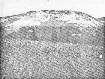 |
| Fig. 5f. Herbland type on upper portions of Chicken Ridge and in the foreground. |
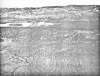 |
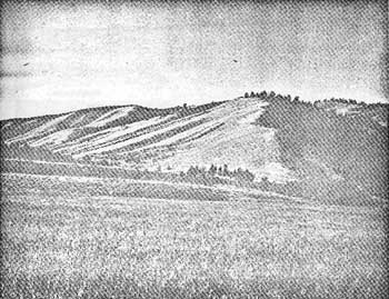
| Fig. 5g. Interspersed forest park, burn, and upland forest types with herbland above the upper half of Red Creek Ridge. |
 |
| Fig. 5h. Extensive subalpine meadow type with scattered Englemman spruce-subalpine fir stands on Pitchstone Plateau. |
Continued >>>
 Top
Top
Last Modified: Tues, Jan 20 2004 10:00:00 pm PDT
http://www.cr.nps.gov/history/online_books/fauna8/fauna1a.htm
![]()