![]()
Cover Page
MENU
![]() Rohwer
Rohwer
|
| |
Confinement and Ethnicity: An Overview of World War II Japanese American Relocation Sites by J. Burton, M. Farrell, F. Lord, and R. Lord |

|
|
| |
Chapter 11 (continued)
Rohwer Relocation Center
Central (Fenced) Area
Today the relocation center site is partly agricultural fields and partly developed with scattered houses and the Desha Central High School. A few relocation center road segments remain, including portions of Eye, D, F, 6th, and 7th streets. The concrete water reservoir and the hospital boiler room smokestack are the only standing structures.
Hospital, Administration, and Warehouse Areas
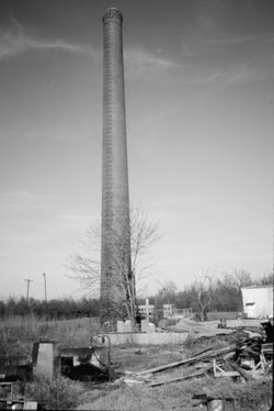 Figure 11.16. Hospital boiler house smokestack. |
The present high school auditorium, made of yellow concrete block, looks very similar in form to relocation center buildings (Figure 11.18). However, the current building does not date to the relocation center as has been suggested (Hoshiko 1992). The relocation center auditorium was used by the high school following closure of the center, but it was constructed of wood and burned down in the 1950s (Figure 11.19). According to WRA blueprints, the original auditorium was over 2,000 feet south of the present auditorium.
In the administration area there are now numerous homes, a church, and other buildings (Figure 11.20). Only a few features remain. A short concrete drive north of what was once Eye Street appears to be from the relocation center. Just south of the former Eye Street is the slab and concrete vault of the post office (Figure 11.21). Amongst the houses there are also scattered small concrete slabs and an isolated section of sidewalk that may be associated with the relocation center.
In the northeastern portion of the relocation center there are debris and foundation remnants from warehouses. The railroad siding that serviced the relocation center is gone, and the railroad itself has been recently abandoned (Figure 11.22). It is posted at all road crossings as owned by Arkansas State Parks.


 Top
Top
Last Modified: Fri, Sep 1 2000 07:08:48 pm PDT
http://www.cr.nps.gov/history/online_books/anthropology74/ce11b.htm
![]()