![]()
Cover Page
MENU
![]() Rohwer
Rohwer
|
| |
Confinement and Ethnicity: An Overview of World War II Japanese American Relocation Sites by J. Burton, M. Farrell, F. Lord, and R. Lord |

|
|
| |
Chapter 11 (continued)
Rohwer Relocation Center
Central (Fenced) Area
Residential Area
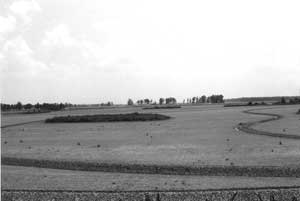 Figure 11.23. Former residential area at Rohwer, now a rice field. Dark vegegation patch is rubble where concrete foundations from the mess hall and bathroom/laundry buildings have been consolidated. |
At Block 21, the rubble mound includes slab foundation debris possibly from the relocation center school auditorium and library. Block 22 is marked by the concrete water reservoir, which is still standing. Measuring 75 feet in diameter by 15 feet tall, it is almost completely hidden by vegetation (Figure 11.25). Just east of the reservoir, at the former location of the relocation center fire station, there is a dense growth of vegetation covering a concrete slab and rubble.
Near the water reservoir, within what was Block 38, there is a well house in the same location as one depicted on WRA blueprints (Figure 11.26). Made of concrete block rather than wood, the building likely rests on the original relocation-center-era concrete slab. According to a local resident, the relocation center water system is still used to supply water for area homes.
Other portions of the relocation center's subsurface utilities remain buried but are currently unused, such as a sewer line exposed by an irrigation ditch (Figure 11.27). The only artifacts seen in the fields were some brick and concrete fragments. No domestic trash dump, or even scattered domestic trash, was observed.


 Top
Top
Last Modified: Fri, Sep 1 2000 07:08:48 pm PDT
http://www.cr.nps.gov/history/online_books/anthropology74/ce11c.htm
![]()