MENU
|
| |
Confinement and Ethnicity: An Overview of World War II Japanese American Relocation Sites by J. Burton, M. Farrell, F. Lord, and R. Lord |

|
|
| |
Chapter 11 (continued)
Rohwer Relocation Center
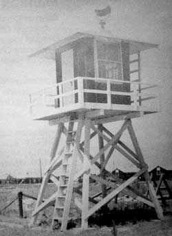
The relocation center at Rohwer was divided into 51 blocks surrounded by a barbed wire fence, a patrol road, and eight watch towers (Figures 11.4 and 11.5). All of the blocks were on a north-south grid. The southern two-thirds of the central area were residential blocks; warehouses were located in the northeast corner just north of the main entrance, which was along the east side. The administration and hospital areas lay to the west of the warehouses, and the military police compound was along the east boundary just south of the main entrance.
 Figure 11.5. Rohwer Relocation Center central area. (click image for larger size (~172K) ) |
 Figure 11.4. Watch tower at Rohwer. (from Rohwer Reunion Committee 1990) |
There were over 620 buildings at the center. The military police compound (designated Block 30), included 12 buildings. Across the road from the military police compound was the receiving building at the main entrance. The administration area (Block 44) also had 12 buildings when first built, but up to 15 staff apartment buildings were later constructed using evacuee labor (Figure 11.8). The warehouse area (Block 50) had 21 buildings, and the hospital area (Block 47) had 17 buildings. An area north of the warehouses was used for coal storage (Block 51). Blocks 44 and 45, along Eye Street, included the post office, a sawmill, a plumbing shop, and three warehouses. There were also three other warehouses along Eye Street in Blocks 30 and 47. A cannery was located north of the hospital.
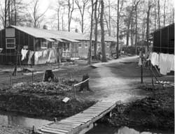
The 36 residential blocks were located south of the administration area. They lay within a rectangle eight blocks east-west by six blocks north-south. To combat muddy conditions each block was surrounded by a drainage ditch, and gravel and wooden sidewalks were constructed between the barracks (Figures 11.9 and 11.10). The southwest portion of the residential area was an especially low area, which after rains would become flooded even above the level of the wooden sidewalks. Sometimes buildings had to be sandbagged to prevent them from being flooded (Rohwer Reunion Committee 1990).
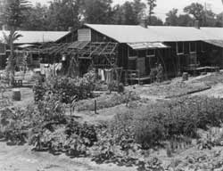
Each residential block had twelve 20-foot-by-120-foot barracks, a recreation building, a mess hall, and a combined bathroom and laundry building. Many evacuees planted vegetable and flower gardens to beautify their new homes (Figures 11.11 and 11.12). Recreation buildings were used for stores, churches, movies, girl and boy scout meetings, a toy library, YWCA, Judo, boxing, weaving, sewing, and other activities (Rohwer Outpost October 1989). All the standard buildings in residential Blocks 31 and 35 were used for elementary and high schools (Rohwer Outpost 11/7/42), and Block 35 had an extra building built for school use. Well houses were located in Blocks 23 and 38 of the residential area.
 Figure 11.10. Drainage ditch in residential block at Rohwer. (Gretchen Van Tassel photograph, Bancroft Library, University of California, Berkeley) |
 Figure 11.11. Evacuee garden at Rohwer. (Charles E. Mace photograph, Bancroft Library, University of California, Berkeley) |
Some of the residential blocks had special functions and therefore had different configurations of buildings, or no buildings at all. Block 21 had only a school auditorium and school library, Block 36 had a school shop, and Block 22 had a fire house, a pumping station, a reservoir, and an unidentified building. Blocks 18, 37, and 45 were open areas.
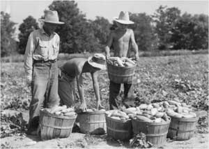
 Figure 11.14. Harvesting cucumbers at Rohwer. (Charles E. Mace photograph, Bancroft Library, University of California, Berkeley) |
As at the Jerome Relocation Center, evacuees working outside the fenced area were subject to harassment caused by mistaken identity. Early in the relocation center occupation, evacuee volunteers clearing brush were reportedly taken off to a local jail at gunpoint by local residents who thought they were Japanese paratroopers (Hayashi 1997).
When the relocation center was closed, 120 acres were deeded to the local school district and the rest was sold back to the original farmers or to veterans. The Desha Central High School originally used two of the hospital buildings (Stuart 1979), the high school auditorium, and perhaps other relocation center buildings. However, none of these remain today. Equipment and buildings were also sold to bidders across the country; some barracks are still in use on the Southern Illinois University campus (Hoshiko 1988).
 Top
Top
Last Modified: Fri, Sep 1 2000 07:08:48 pm PDT
http://www.cr.nps.gov/history/online_books/anthropology74/ce11a.htm
![]()


