|
|

NPS Graphic Mount Rainier National Park is located in west-central Washington state. Several major cities in Washington, including Seattle, Tacoma, and Yakima, as well as Portland, Oregon, are within 200 miles of the park. Always check the road status page before planning a trip to the park. Unexpected road closures may occur at any time due to the dynamic nature of Mount Rainier. Also check Alerts to get the most up-to-date notices of road status and gate closures. Avoid Summer CongestionOn busy summer weekends expect long waits at entrances and full parking lots. Plan ahead and follow these tips to avoid summer traffic. Maps of Mount RainierView and download maps of Mount Rainier National Park, area trail maps, and more! | |||||||||||||||
Traffic & Travel TipsPark roads are winding with narrow shoulders and the maximum speed limit is 35 mph in most areas. Allow plenty of travel time during your visit. Traveling in SummerOn a sunny summer weekend, it can be difficult or impossible to find parking at Paradise, Sunrise, Grove of the Patriarchs, and at the trailheads between Longmire and Paradise. To help avoid this congestion, it is recommended to visit these areas on weekdays, arrive early in the day, and carpool to the park if possible. Parking is not permitted along the road edges. Traveling in WinterMany of the park roads close in winter. The road to Paradise closes nightly during winter months, and road conditions are often snowy and icy. All vehicles are required to carry tire chains. Learn more about Winter Travel, including information on gate closures, and Tire Chain Frequently-Asked-Questions Directions to the ParkHow Far Is It?One way driving times and distances to areas within the park. Many roads close for the winter; always check road status. View and download park maps.
| ||||||||||||||||
Southwest Entrance - By CarYear-round access to the park is via SR 706 to the Nisqually Entrance in the southwest corner of the park. The road from the entrance to Longmire remains open throughout winter except during extreme weather. The road from Longmire to Paradise closes nightly from November 1 through winter. It reopens the following morning dependent upon snow removal and current conditions. Even though roads will be open, some facilities may not be available. A note on using GPS: Many visitors now use GPS (Global Positioning System) units to help them navigate while driving. However, the street address for Mount Rainier National Park (55210 238th Avenue East) leads to the Mount Rainier headquarters in Ashford, Washington, NOT to the Nisqually entrance of the park. To reach the Nisqually entrance using GPS use the address 39000 State Route 706 E, Ashford, WA 98304. This will take you on SR 706 east past the park headquarters to the Nisqually Entrance. It is recommended that visitors refer to road maps in addition to using GPS units when driving to the park. Electric Vehicle Charging StationsElectric vehicle charging stations are available at Longmire year-round and at Paradise during the summer season, operated by Rainier Guest Services (RGS) (check RGS website for current operating status). If you are interested in using them, visit the corresponding lodging operation (National Park Inn for Longmire and Paradise Inn for Paradise) to get their access code. Pricing will be based upon the amount of time requested and acceptance rate of energy (Tier 1, 2, or 3) requested.
|
Directions to the Southwest Entrance of the park (Nisqually, Longmire and Paradise) from Seattle, Tacoma, Yakima, or Portland:
| |||||||||||||||
Northwest Entrance - By CarCarbon River and Mowich Lake in the northwest are not accessible via SR165 due to the closure of the Fairfax Bridge. The bridge is closed to pedestrians, bicycles, and vehicles and there is no alternate route. WSDOT News Release, 4/22/25.
| ||||||||||||||||

NPS Photo East Entrances - By CarSoutheast - Spring through fall road closures depend on snowfall and its removal from the roadways. Ohanapecosh on SR 123 is generally open via Hwy 12 from Yakima or Packwood from late May to early November. Access to other areas of the park from Ohanapecosh may be closed during the early and later seasons so please check the road status while making your plans. Northeast - Sunrise, White River and southbound SR 123 are accessed via SR 410 from Enumclaw. The road to Sunrise is usually open by July 1st through early September, as is the visitor center and other facilities. The road to Sunrise closes at the junction with White River Campground every night beginning in late September. It reopens each morning as conditions permit. The entire road from the junction with SR 410 to Sunrise and White River is closed for winter in mid-October or earlier with the first heavy snowfall. East/Chinook Pass - In the summer, travelers coming from east of the Cascades can enter the park using Chinook Pass (SR 410) and Cayuse Pass (SRs 123 & 410) or via I-90 and US 12. In winter, however, SR 123 and SR 410 are closed. For winter access to the east side of the park, visitors must use I-90 and US 12. |
Directions to the East Side of the park (Ohanapecosh, Sunrise and White River) from Seattle, Tacoma, Yakima, or Portland:
| |||||||||||||||

NPS Historic Photo By PlaneThree airports, served by major airlines are located near Mount Rainier: Seattle-Tacoma International Airport is located in Seattle, Washington. The one-way distance from the Seattle to the town of Ashford, located just outside the Nisqually entrance in the southwest corner of the park, is 85 miles. Yakima Air Terminal is located in Yakima, Washington. The one-way distance from the Yakima to town of Ashford, located just outside the Nisqually entrance in the southwest corner of the park, is 134 miles. 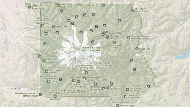
Park Maps
Maps of Mount Rainier National Park, including the Wilderness Trip Planner Map and area trail maps. 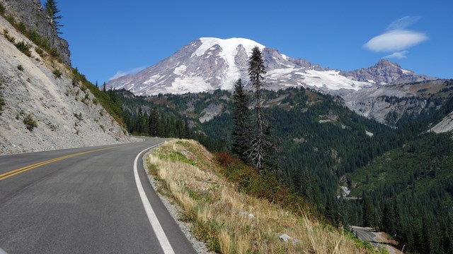
Road Status
Find out current road conditions, including access to Paradise during the winter season. 
Park Construction
Park construction includes work to improve roads and visitor areas. Learn how this will impact your travel plans through the park. | ||||||||||||||||
Last updated: August 22, 2025