Camping

Camping Permit Form

All visitors planning to camp overnight in the park must obtain a free camping permit. There are no fees. A permit must be filled out using the online form below or by visiting the park office located at 508 E 2nd St, Yankton, SD 57078. An email address is required to receive an electronic copy of the permit.

Permits are approved upon submittal and valid unless revoked by the Superintendent or authorized personnel. Campers may present their permit information electronically, but it is recommended to keep a printed copy in case of poor cellular reception, power loss, or device malfunction. All campers must adhere to the regulations outlined in the Superintendent’s Compendium which can be reviewed at: (https://www.nps.gov/mnrr/learn/management/compendium.htm

All sites are first come first served.  

Due to the remoteness of our camping areas, completion of this form is critical to ensuring your safety. Check out our safety tips at: https://www.nps.gov/mnrr/planyourvisit/safety.htm  

NPS Form 10-404 (Rev. 08/2017)
National Park Service

OMB Control No. 1024-0022
Expiration Date 01/31/2024

For the purposes of improving your visit, the National Park Service may seek to understand more about your visitor experience on this Wilderness/Backcountry trip. Are you willing to allow your contact information be used to follow up on social science information needs by the NPS in the future?

Type of Backcountry Use

Type of Watercraft

Vehicle

 Yes

Aircraft

 Yes

Watercraft

 Yes

Snowmobile

 Yes

Off-Road Vehicle (ORV)

 Yes

Privacy Act Statement

General: This information is provided pursuant to Public Law 93-579 (Privacy Act of 1974), December 21, 1984, for individuals completing this form.

Authority: 54 U.S.C. §100101, NPS Organic Act; 16 U.S.C. 1131-1136, Wilderness Act; 43 U.S.C. §1701 et seq., the Federal Land Policy and Management Act; 54 U.S.C. §200301-200310, Land and Water Conservation Fund Act, as amended; 16 U.S.C. §6801-6814, the Federal Lands Recreation Enhancement Act; 36 CFR Part 71, Recreation Fees; and, 36 CFR 1.6, Permits.

Purpose and Uses: To establish and verify an applicant's eligibility for a permit to conduct certain activities within the National Park System and to process permits for individual members of the public and organizations interested in obtaining a permit authorizing an activity. Information collected will be used to provide the public and permittees with permit-related information, to monitor activities conducted under a permit, to analyze data and produce reports to monitor the use park resources, to assess the impact of permitted activities on the conservation and management of protected species and their habitats, and to evaluate the effectiveness of the permit programs. The DOI and NPS may use the information to meet reporting requirements, to generate budget estimates and track performance, and to assist park staff with visitors’ education, fee collection, resource management and protection, recreational use planning, law enforcement and public safety personnel for such purposes as emergency contact and search and rescue efforts; to provide permit holders and participants with information about parks and their partners; and to provide reports of activities conducted under an issued permit.

Based on the disclosures generally permitted under 5 U.S.C. 552a(b) of the Privacy Act, the National Park Service may share information with first responders and Federal, state, and local governments to provide information needed to locate an individual or render aid in an emergency; to recover debts owed to the United States; to respond to a violation or potential violation of the law; in response to a court order and/or discovery purposes related to litigation; or other authorized routine use when the disclosure is compatible with the purpose for which the records were compiled.

Effects of Nondisclosure: It is in your best interest to answer all of the questions. The U.S. Criminal Code, Title 18 U.S.C. 1001, provides that knowingly falsifying or concealing a material fact is a felony that may result in fines of up to $10,000 or 5 years in prison, or both. Deliberately and materially making false or fraudulent statements on this form will be grounds for not granting you a Backcountry/Wilderness Use Permit.

Information Regarding Disclosure of Your Social Security Number Under Public Law 93-579 Section 7(b): Your Social Security Number is not needed to complete this form.

Paperwork Reduction Act Statement

We are collecting this information subject to the Paperwork Reduction Act (44 U.S.C. 3501) and 36 CFR 1-7, 12 and 13 which authorize the National Park Service to require applicants to fill out this form to monitor resources and to protect visitors. This information is being collected to allow the park management to make value judgements necessary to enhance the safety and enjoyment of both the visitors and wildlife. All applicable parts of the form must be completed in order for your request to be considered. You are not required to respond to this or any other Federal agency-sponsored information collection unless it displays a currently valid OMB control number.

Estimated Burden Statement

Public Reporting burden for this form is estimated to average 8 minutes per response, including the time it takes for reviewing instructions, gathering and maintaining data, and completing and reviewing the form. Comments regarding this burden estimate or any aspect of this form should be sent to the Information Collection Clearance Officer, National Park Service, 12201 Sunrise Valley Dr. (MS-242), Reston, VA 20192.
 
Three separate images that include Green Island, Goat Island, and Bow Creek Recreation Area that highlight environmentally sensitive areas. The park requests no camping in these areas.
Images showing environmentally sensitive areas at Goat Island, Bow Creek Recreational Area,  and Green Island.

NPS

Environmentally Sensitive Areas

There are three areas for visitors to camp at in the park and all three have environmentally sensitive areas that are highlighted on the maps to the left. These areas should be avoided, if possible, for ecosystem protection.

MAP DISCLAIMER

The National Park Service shall not be held liable for improper or incorrect use of the data described and/or contained herein. These data and related graphics (i.e., GIF or JPG format files) are not legal documents and are not intended to be used as such. The information contained in these data is dynamic and may change over time. The data are not better than the original sources from which they were derived. It is the responsibility of the data user to use the data appropriately and consistent within the limitations of geospatial data in general and these data in particular. The related graphics are intended to aid the data user in acquiring relevant data; it is not appropriate to use the related graphics as data. The National Park Service gives no warranty, expressed or implied, as to the accuracy, reliability, or completeness of these data. It is strongly recommended that these data are directly acquired from an NPS server and not indirectly through other sources which may have changed the data in some way. Although these data have been processed successfully on computer systems at the National Park Service, no warranty expressed or implied is made regarding the utility of the data on other systems for general or scientific purposes, nor shall the act of distribution constitute any such warranty. This disclaimer applies both to individual use of the data and aggregate use with other data.

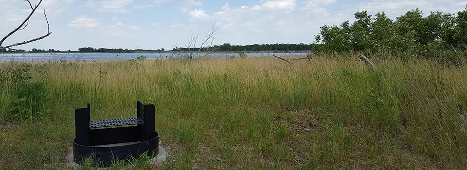
A metal fire ring in a grassy campsite. The Missouri River is in the background.
The park offers primitive, Leave-No-Trace camping with designated fire rings.

NPS Photo

Missouri National Recreational River offers primitive, Leave-No-Trace camping available at Bow Creek, Green Island, and Goat Island Recreation Areas. No camping fees are required but we do ask that you leave us your basic itinerary for your safety.

Please call 605-665-0209 and be prepared to share your name, phone number, the site location you plan to camp including the dates of when you will arrive and depart from park property.

Other Camping Options

Nebraska

Corps Of Engineers
1-877-444-6777 or visit reservations

  • The U.S. Army Corps of Engineers manages two campgrounds in the Gavins Point Dam area: Cottonwood and Nebraska Tailwaters, both in Nebraska. Reservations are taken for the period from Memorial Day weekend through Labor Day weekend.

Nebraska State Parks
402-471-1414 or visit reservations

  • Lewis and Clark State Recreation Area - just above Gavins Point Dam - has 150 camping pads with hookup areas, 24 non-pad sites with electrical hook-ups and 140 non-pad sites without electricity.
  • Niobrara State Park - just outside of the village of Niobrara 76 camping pads with electrical hookups,30 dispersed non-pad sites without electricity and 20 cabins that may be reserved.
  • Ponca State Park - just 25 miles outside Sioux City, Iowa - has 92 camping pads with electrical hookups, 75 non-pad sites without electricity and 31 cabins that can be reserved.

Boat Landings / River Access Camping

Primitive camping is available at Nebraska Game and Parks Commission Game Management Areas river access areas unless posted otherwise at the following locations:

Note: Game Production Areas are managed by the Nebraska Game and Parks Commission’s Wildlife Division for the enhancement of wildlife habitat and for public hunting, trapping and fishing. However, they are open to many other activities, including hiking, bird watching, nature study and primitive camping. Camping is free and permitted for a maximum of 14 consecutive days during any 30-day period. Quiet hours are in effect from 10pm to 6am. Place all trash in receptacles or “Pack It Out”. For more information visit OutdoorNebraska.org.

South Dakota

  • Clay County Park - Located 4 miles southwest west of Vermillion, South Dakota, this is a quiet, secluded campground with tall trees and nearby access to one of the last natural stretches of the Missouri River has 32 electrical campsites and restrooms with showers.

South Dakota State Parks
1-800-710-2267 or visit reservations

  • Lewis and Clark Recreation Area - located just a few miles outside of Yankton, this is the most visited outdoor recreation area in the eastern half of South Dakota. It has hundreds of sites along with a number of rental cabins at five different campgrounds: Gavins Point, East Midway, West Midway, Yankton and Horse Trail Camp. The area also includes the Chief White Crane and Pierson Ranch campgrounds.
    Phone: 605-668-2985

  • North Point Recreation Area - is just above Fort Randall Dam. It has 111 sites along with 6 cabins, including 2 that are handicap accessible.

  • Randall Creek Recreation Area - is right along the banks of the Missouri River just downstream from Fort Randall Dam. It has 132 sites along with 4 cabins available.

  • Springfield State Recreation Area - is between Yankton and Fort Randall, it lies just below the 39 mile reach of the Missouri National Recreational River. It has 22 sites along with 2 cabins available.

Camping in your National Parks

  • Find your camp in a National Park near you!

Information on camping safety


Tips for Camping Trips

Loading results...

    Last updated: November 6, 2023

    Park footer

    Contact Info

    Mailing Address:

    508 East 2nd Street
    Yankton, SD 57078

    Phone:

    605-665-0209 x21

    Contact Us