Relevant InformationLassen Park Highway, part of Highway 89, is the only road through the park. Many of the park’s features, popular trails, and visitor services are along this road. Three additional roads provide access to more remote areas: Butte Lake, Juniper Lake, and Warner Valley. Winter Road ClosuresDuring the snowy season (approximately November – June), park roads are closed and/or impassible due to heavy snowfall. Road closures are listed in alerts on the top of every webpage. Closures and additional information are available on the Current Conditions page. Lassen Park HighwayThe park’s main road is a 30-mile (48km) stretch of Highway 89 that runs north-south through the park. This scenic route passes through dense forest, open ridgelines cresting 8,512 feet near Lassen Peak trailhead, and descends steep volcanic slopes into the southwest area. Typically, the drive takes about one hour without stopping. Learn more about driving the park highway. Travel Tips
Park Highway Alternatives in WinterIt is possible to travel from one park entrance to the other on outside roads around either the east or west side of the park. Travel Around the West Side of the ParkThis route is the shortest route around the park. This windy road is not recommended for RVs and trailers. Average travel time is 1 hour, 45 minutes. Average distance is 71 miles. View directions in Google Maps.
Travel Around the East Side of the ParkThis route is slightly longer than the west route, however it has fewer curves and is appropriate for RVs and trailers. Average travel time is two hours. Average distance is 106 Miles. View directions on Google Maps.
Area Map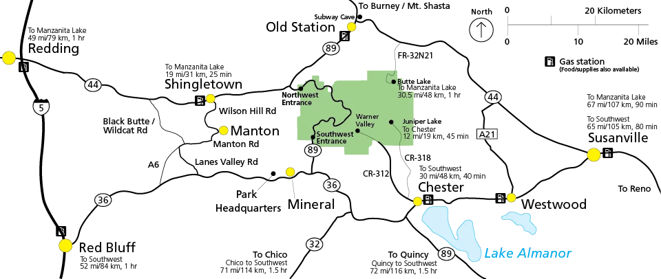
NPS Graphic Roads to Outlying / Remote AreasButte Lake Road (FR-32N21)A 6-mile dirt/gravel road is used to access the Butte Lake area. Although typically passable by passenger vehicles, the road may be rutted and dusty in midsummer. The road is partly within Lassen National Forest and partly within the park. Butte Lake is 31 miles (50km) from the Northwest Entrance / Manzanita Lake area. Butte Lake Road is not maintained in winter; vehicle travel is not advised when snow covers the road (approx. November – April). Butte Lake Directions in Google Maps Driving Directions from Northwest Entrance:
Juniper Lake Road (CR-318)A 13-mile, partly-unpaved road is used to access the Juniper Lake area. The last six miles is rough dirt road with steep sections and is not suitable for buses, motorhomes, or trailers. The road is partly within Plumas County, Lassen National Forest, and the park. Juniper Lake is 38 miles (61km) from the Southwest Entrance / Southwest Area. Juniper Lake Road is not maintained in winter; vehicle travel is not advised when snow covers the road (approx. November – June). Juniper Lake Directions in Google Maps Driving Directions from Kohm Yah-mah-nee Visitor Center
Warner Valley Road (CR-312)A 13-mile, partly-unpaved road is used to access the Warner Valley area. The last three miles is dirt road with steep sections and is not recommended for trailers. The road is partly within Plumas County, Lassen National Forest, and the park. Warner Valley is 38 miles (61km) from the Southwest Entrance / Southwest Area. Warner Valley Road is not maintained in winter; vehicle travel is not advised when snow covers the road (approx. November – June). Warner Valley Directions in Google Maps Driving Directions from Kohm Yah-mah-nee Visitor Center
|
Last updated: December 3, 2025