
NPS photo. Our history of fire management stretches back to the early 1900s, when hundreds of thousands of acres were being protected as national parks, forests, and other public lands. Trees hold the record of fire history extending back hundreds of years. During this time, many land managers began a widespread program of fire exclusion. This meant that they put out all fires, believing they were protecting lands, plants, and animals from what they saw as fire's destructive force. What happened without fire? Across the country, plant and animal communities began to change without the regular fires that had burned across fire-prone landscapes for thousands of years. Fires that did start often burned hotter, faster, and farther than they had before because thick layers of fuel (tree branches, leaves, dry grasses and other flammable debris) had built up on the ground. 
NPS photo. In Great Smoky Mountains National Park, the policy of fire exclusion reshaped some of our native plant and animal communities. People often think of moss-draped, dripping rock ledges in the Smokies, or rhododendron-shaded streamsides. While we have these, we also have long dry ridges of pine-oak forest, sloping hillsides covered with oak forests, and wide, flat grasslands that depend on fire for health and regeneration. From decades without regular fires, we’ve learned what an important process fire can be.

NPS photo by Heath Bailey. It’s no easy task to reintroduce fire to a dry, crowded forest in which fuel has built up for decades. Because managers realized it belonged in many landscapes, however, they began to try. Since the 1980s, the policy in the National Park Service (and most other federal protected lands) has been to use controlled burns. Also called prescribed fires, controlled burns are just what they sound like: fires that burn under control, when and where we plan. Learn how a park team sets about conducting a controlled burn.
Actually setting fires is just one part of the entire fire management program. Learn about each team and how they contribute to controlling fire in our national parks. 
Engine Crew and the Fire Cache The Fire Cache is a place—a storage cache of tools and equipment—and the people who run it are the crew of Engine 62. Long before the snow melted and the trees sent out their first leaf buds for this fire season, the crew is busy at park headquarters putting together the tools and equipment that would support the Canadian Top controlled burn. The engine crew is based in the Smokies and their primary duty is this park, although they sometimes support Fire Management activities in other parks around the Southeast region as well. The members of the engine crew lead firefighters to put out local fires that start, as well as coordinate logistics—supplies, vehicles, locations of crews and engines—on larger wildfires and controlled burns. The fire cache works hand in hand with local and state fire departments to keep the wildland environment—a term that describes undeveloped land—safer when uncontrolled fires break out. The engine crew not only provides and maintains all of the gear and equipment necessary for fire management activities, but they also service two remote-automated weather stations in the park that help fire managers know how they can expect fire to behave. Fire “behavior” simply describes how it fires burn across a landscape as the wind pushes it along, as humidity makes it flare up or die down, and as rain or sun affect it. 
NPS photo. Fire Effects Crew The Fire Effects Crew monitors the short- and long-term effects of fire on native plant communities. To understand how fire has changed a landscape, they must first carefully document the plants, animals, and other characteristics of the burn site before fire affects it. They create study plots—small, rectangular areas that they mark with (nonflammable) metal posts so they’ll be able to find the same spot after the burn—and document every single species they find within each one. They also note the health of the vegetation in the plots—whether native plants thrive, which plants are growing together in a community, and the overall number of different plants, which indicates diversity. 
NPS photo. The fire effects crew travels to controlled burn sites throughout the Southeast region, and often helps prepare the site by moving fuel, cutting down hazard trees, and taking fuel (e.g. leaf litter) moisture and weather readings. They may help ignite the fire using drip torches, and are on scene to help control the fire’s edges and monitor the fire’s behavior. 
NPS photo. Immediately after the fire, and in the seasons after the controlled burn, the fire effects crew returns to the study plots and documents which plants have regrown and how the overall plant community has responded. They carefully document each site with photographs to show change over time. 
NPS photo. Wildland Fire Module The Wildland Fire Module manages fire in national parks throughout the Southeast region. Although it is based in Great Smoky Mountains National Park, the "Module" also serves National Parks throughout the southeast region. Some of the other parks where they work include Gulf Islands National Seashore, Timucuan Ecological and Historic Preserve, Horseshoe Bend National Military Park, Little River Canyon National Preserve, Russell Cave National Monument, and Kings Mountain National Military Park. Pre-fire, members of the module travel to each park, talk with biologists and cultural resource managers, and select the site for burning. They assess whether the burn area has natural fire breaks (such as gaps in fuel, changes in topography, streams, or roads that would stop the fire from spreading beyond a controlled area), map the topography of the landscape, visit the site, and figure out if a fire in this location presents any special hazards. These could include buildings in or near the burn area, smoke potentially drifting across public roads, or neighbors with special health concerns who shouldn’t be exposed to smoke and particles. All of this information goes into very detailed burn plans well in advance of any fire on the ground. On the morning of the proposed burn, Wildland Fire Module members monitor the wind, humidity, fuel moisture, and temperature as everyone prepares the area for the fire. If everything checks out, they ignite the fire using drip torches and sometimes helicopters, and monitor the progress of the fire very, very carefully. 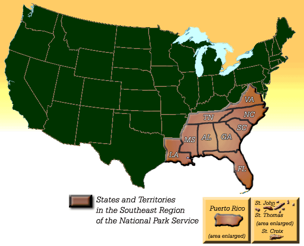
NPS graphic. One thing that may surprise you is how much fire played a part in the Southeastern landscape before we suppressed it. Therefore, the fire management program is one of the most active in the United States. The Southeast Region includes a diverse range of landscapes, from the high mountains of the Smokies to the flat, lightning-flashed plains of Florida. This region
Links to other information about fire and fire management: Firewise, a program sponsored by the National Wildland/Urban Interface Fire Program Fire Ecology in the Southeastern United States (opens pdf document)
|
Last updated: November 12, 2015