News Release
You are viewing ARCHIVED content published online before January 20, 2025.
Please note that this content is NOT UPDATED, and links may not work. For current information,
visit https://www.nps.gov/aboutus/news/index.htm.

|
Subscribe
|
Contact: NPS Contact: Brandalyn Vonk, 602-730-6144
Contact: USFS Contact: Jacqueline Banks, 928-635-8314
Contact: Ikes Fire Public Information Office, 928-638-7071
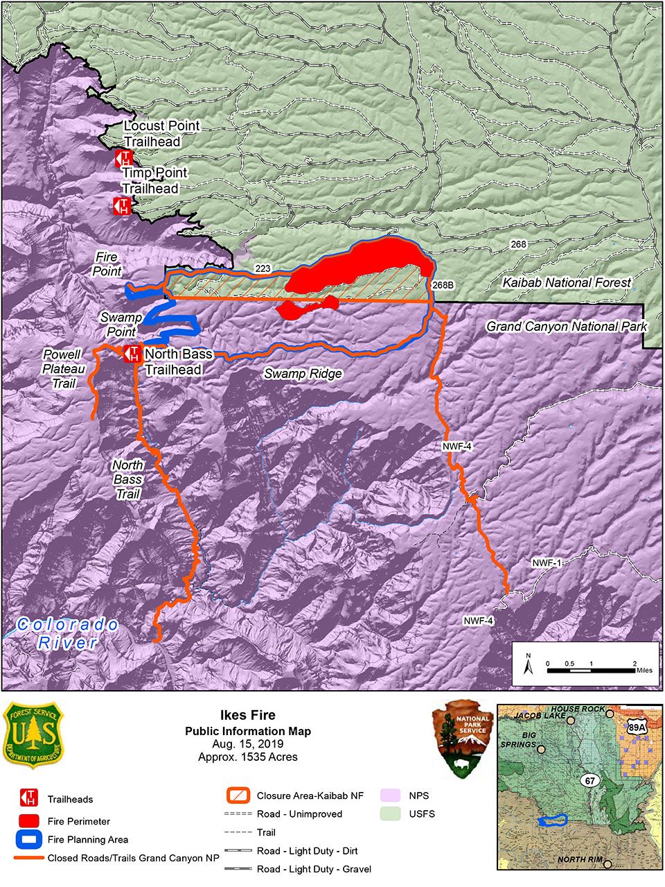
Grand Canyon, AZ- Warm, dry weather conditions have led to additional growth on the Ikes Fire, which is now approximately 1,535 acres and 20% contained. The Ikes Fire is being utilized to fulfill its natural role within a fire-dependent ecosystem. The fire continued to spread naturally across National Park Service land and crossed the boundary onto Forest Service land. Fire helps to remove debris along the forest floor, causing it to open up to sunlight. Once the fire burns excess vegetation, it returns nutrients to the soil and encourages the growth of vegetation such as grasses and shrubs. Removing vegetation can help trees to grow stronger and healthier as it helps to reduce competition across the landscape. This new growth provides food and habitat for wildlife.The Ikes Fire transitioned from a Type 3 Incident Management Team to a Type 4 at 6:30 AM. Yesterday crews continued firing operations to secure the northern and eastern boundaries of the planning area. Hand ignitions occurred along the perimeter to reduce fuels and strengthen control lines already in place. A helicopter was utilized for aerial ignitions to place fire in areas not easily accessible to crews due to safety risks. Firing operations are expected to continue for the next few days as weather conditions allow. Strengthening the perimeter is a high priority due to an expected increase in winds later this week. The lightning-caused wildfire is actively burning within a 7,785-acre planning area.
The predicted weather is mostly sunny, with no precipitation over the next few days. Strong winds forecasted at the end of the week may produce gusts up to 25 mph. Winds could push smoke east towards State Highway 67 between De Motte Campground and Jacob's Lake. Multiple fires within the area surrounding the Grand Canyon may continue to produce visible smoke from both the North and South Rims. Smoke settled into the Grand Canyon overnight as temperatures cooled but smoke may begin to lift as temperatures warm up throughout the day.
Approximately 70 personnel are currently assigned to the Ikes Fire, including a Type 2 Initial Attack (IA) crew, five engines, a task force leader, resource advisor, fire effects monitors, and various overhead and support positions. Additional resources will be requested as needed in order to meet management objectives.
Closures remain in effect for the planning area of the Ikes Fire for Grand Canyon National Park and Kaibab National Forest. More information on these closures can be found at https://inciweb.nwcg.gov/incident/closures/6475/.
The Ikes Fire poses no danger to structures or local infrastructure.
Please visit https://www.nps.gov/grca/learn/management/firemanagement.htm for additional information about wildland fire at Grand Canyon National Park or call 928-638-7819 for recorded fire information. For additional information about the Ikes fire, visit
https://inciweb.nwcg.gov/incident/6475/.
For fire information on the Kaibab National Forest, visit www.fs.usda.gov/kaibab or
@KaibabNF on Facebook and Twitter or call (928) 635-8311 for recorded fire information.
Last updated: February 19, 2024
