An official website of the United States government
Here's how you know
Official websites use .gov A
.gov website belongs to an official government
organization in the United States.
Secure .gov websites use HTTPS A
lock (
) or https:// means you've safely connected to
the .gov website. Share sensitive information only on official,
secure websites.
We live in an increasingly crowded world. Yet here you have the chance to hear a porpoise, seal or whale breathe over a prism of still water. Without limits, regulations and everyone’s cooperation, this cherished sense of solitude could decline or even vanish.
Regulations on this page are intended for private boaters.
Between June 1st and August 31st all vessels operating in Glacier Bay are required to hold a permit. Limits on the number of vessels allowed to enter Glacier Bay are intended to protect habitat for marine wildlife including fish, seabirds and marine mammals. By protecting air and water quality, this also provides unparalleled opportunities for wilderness solitude and discovery which makes a trip to Glacier Bay memorable.
Help us protect park wildlife. Park restrictions are intended to protect particularly species, habitats and colonies and regulations may change depending on wildlife activity and the location. Always check with the Visitor Information Station for any additional temporary closures or restrictions before heading out. Keep in mind that these park specific regulations are in addition to Coast Guard regulations and marine mammal protections.
From May 1 through September 30, Vessels are required to contact the park via VHF radio at “KWM20 Bartlett Cove” prior to entering AND exiting Glacier Bay waters. Glacier Bay is defined as those waters north of a line drawn between Point Gustavus and Point Carolus, and west of a line extending north across Bartlett Cove from the fuel dock. You are required to call-in when passing this line when entering Glacier Bay AND when you are exiting. After hours vessel arrivals/departures still require a call in to KWM20. Your arrival/departure will be noted the following morning at start of business.
For example: If you are entering the park from Icy Strait with a plan to dock at the Bartlett Cove Public Use Dock, you are required to call the VIS when passing the line drawn between Point Gustavus and Point Carolus; then, you are required to call again when you cross the line drawn north from the Bartlett Cove Fuel Dock as you approach the main Public Use Dock. Finally, when departing, you must call the VIS again when you exit Bartlett Cove past the Fuel Dock, and when you exit Glacier Bay while passing Points Gustavus and Carolus.
Whale Waters
Whale waters are areas of Glacier Bay National Park that traditionally or temporarily have high numbers of feeding humpback whales, creating a need for extra caution and slower vessel speeds during transit. Vessel operating restrictions in whale waters are intended to minimize whale disturbance and lower the risk of whale/vessel collisions to protect endangered humpback whales.
In areas designated as "whale waters," all motor vessels over 18 feet in length must:
Maintain a distance of at least one nautical mile from shore. In areas where there is less than two nautical miles between shores (i.e. Bartlett Cove and the Beardslee Entrance), navigate using a mid-channel course.
U.S. Coast Guard navigational rules supersede park regulations when navigating in narrow, heavy traffic areas such as Sitakaday Narrows. Boaters are requested to operate their vessels safely while following park regulations.
When approaching the shore (e.g. to approach the dock, or view wildlife), vessels must make a perpendicular approach, and may not operate along the shoreline unless actively fishing.
Boaters must navigate through lower bay whale waters at a speed of no more than 20 knots through the water. The superintendent may impose a speed restriction of 13 knots when warranted by high numbers of whales.
All vessels, including kayaks, operating anywhere in Park waters, including Park waters outside Glacier Bay proper, must NOT:
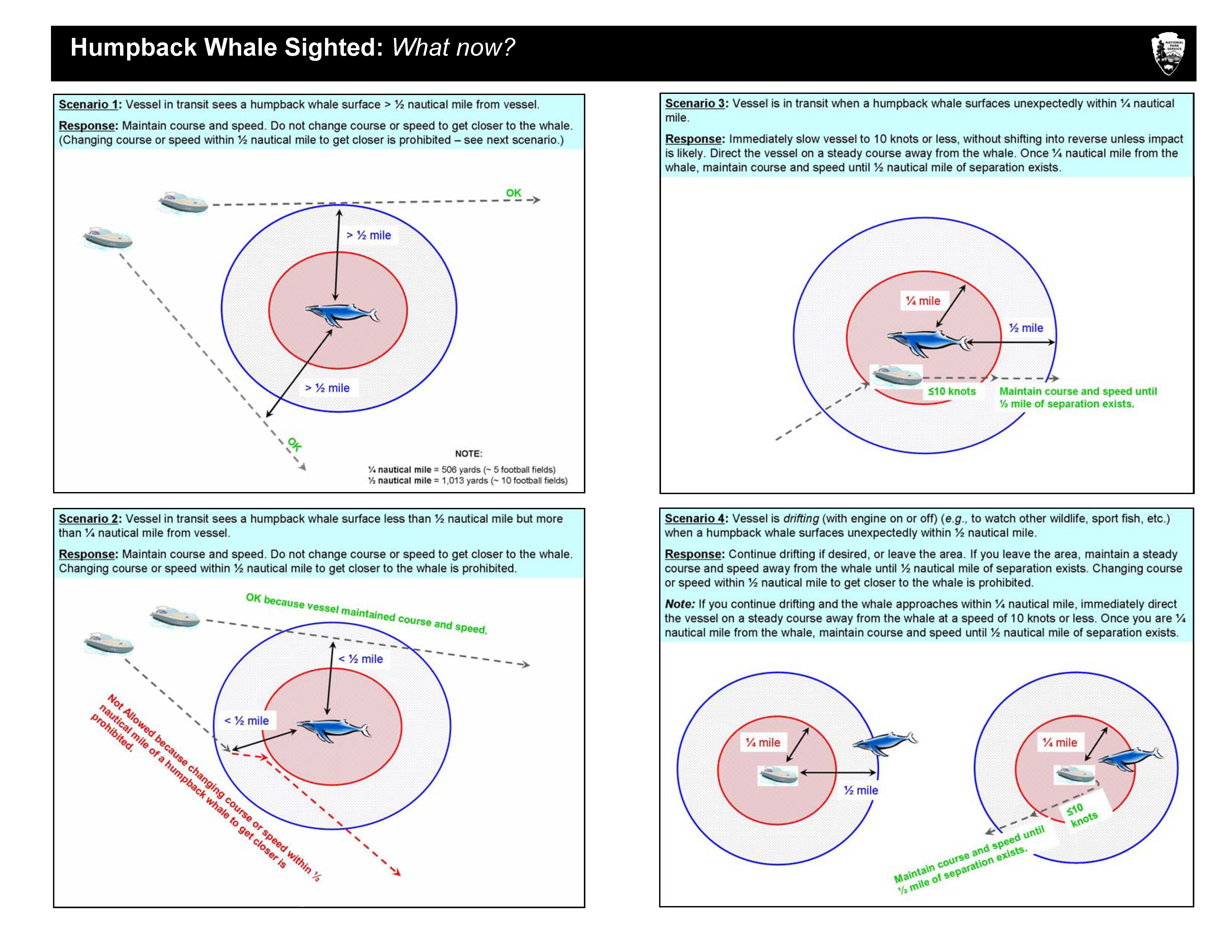
Operate within 1/4 Nautical mile of a humpback whale
Pursue a humpback whale by altering course or speed in a manner that results in retaining a distance less than 1/2 nautical mile from the whale
If your vessel is accidentally positioned within 1/4 nautical mile of a whale, immediately slow your speed to 10 knots or less, without shifting into reverse unless impact is likely. Then, direct or maintain your course away from the whale until at least 1/4 nautical mile of separation exists.
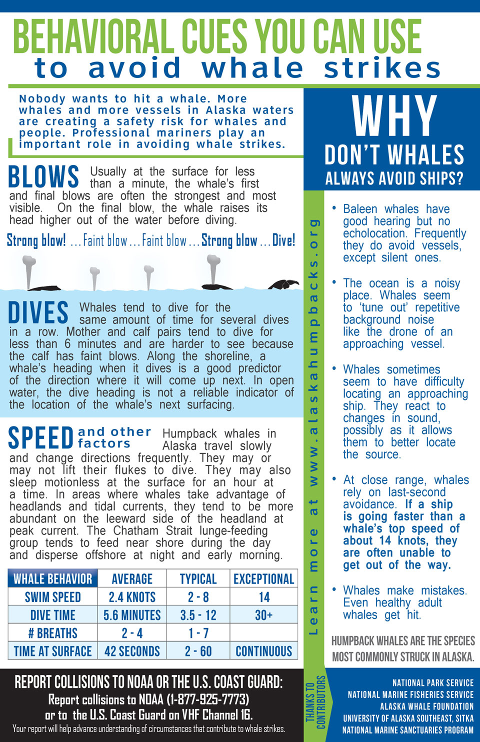
Boaters should proceed cautiously in all areas where whales are present because whales may surface in unexpected locations, posing a hazard to both vessels and the whales. Although humpback whales tend to be distributed along the shoreline, boaters should note that whales frequently cross mid-channel as they move between feeding sites.
Whale Waters Locations
Dates
Lower Bay (Between an imaginary line from Pt. Gustavus to Pt. Carolus, and another imaginary line from the northern tip of Strawberry to Lars Island, including Bartlett Cove and the Beardslee Entrance.)
May 15 - Sep 30
The superintendent may designate additional temporary whale waters. Contact the park for updated information.
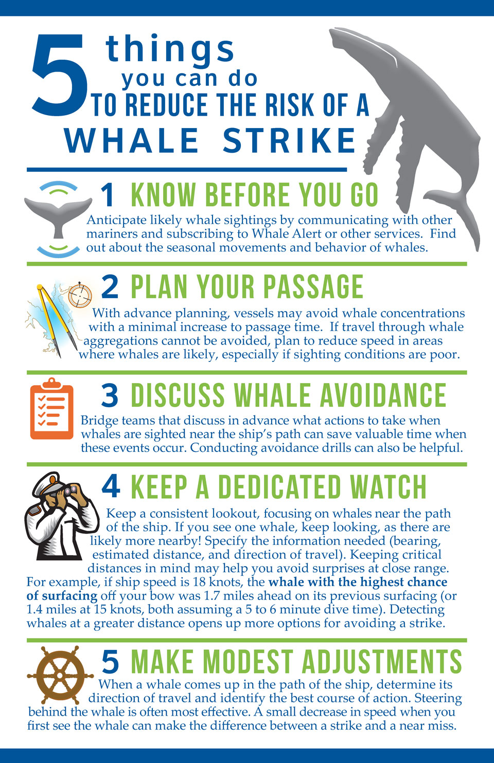
5 Things You Can Do To Reduce The Risk of a Whale Strike This new flyer was produced by Glacier Bay whale biologists in collaboration with a variety of individuals with expertise on whale behavior and ship strike avoidance. Page 1 Page 2
Non-Motorized Waters
In designated areas, all motorized vessels (including seaplanes and sailing vessels with auxiliary motorized propulsion) are restricted from use.
Location
Date
Upper Muir Inlet
June 1 - July 15
Wachusett Inlet
July 16 - August 31
Adams Inlet, Rendu Inlet,
Hugh Miller Inlet, Beardslee Islands
May 1 - September 15
Harbor seal critical areas
These areas offer protection for pupping and molting harbor seals. Peak visitation in Glacier Bay occurs between June and August, Exactly the months of sensitive phases in reproduction and molting for harbor seals. Because harbor seals at haul outs are easily flushed from haul outs by human activities on land or on the water, the NPS prohibits vessel and foot traffic in these areas.
May 1 - June 30
Closed to all vessel traffic from the face of the Johns Hopkins Glacier to an imaginary line from Jaw Point due west.
July 1 - August 31
All vessels (including kayaks) must remain further than 1/4 nautical mile from any seal hauled out on ice , except when safe navigation requires, and then with due care maintain a 1/4/ mile distance from any concentration of seals. Vessel speed must be 10 knots or less.
Steller sea lion critical areas
These areas offer protection for this threatened species when hauled out on land.
Vessels are not allowed to approach any sea lion hauled out on land. In the following areas all vessels must remain further than 100 yards from any sea lion hauled out: Northern 1/2 of South Marble Island, Graves Rocks, Cape Fairweather, Cormorant Rock and all near shore rocks 1 1/2 nautical miles SE from the mouth of Lituya Bay.
Seabird nesting closures
These areas offer protection of seabird nesting habitat from camping, foot traffic, and vessel approach.
Several islands in Glacier Bay are heavily used by nesting seabirds. Some of these islands are closed to all foot traffic during the breeding season to allow seabirds to brood their eggs and raise their chicks to fledging without being disturbed.
Studies have shown that increased energy expenditure from repeated flushing has possible harmful effects on the reproductive success of birds. Therefore, boaters should also refrain from close approaches to seabird nesting areas, and be mindful of boat noise and other disturbances(shouting, sudden movements on deck ,etc.) when arriving and departing near nesting colonies.
The following areas are closed to all camping and foot traffic: South Marble Island, Geikie Rock, Lone Island and the three small unnamed islands approximately one nautical mile southeast of Flapjack Island, Eider Island, Boulder Island, top three-fourths of Leland Island, or any of the four small unnamed islands approximately one nautical mile north and 1.5 nautical miles east of the eastern most point of Russell Island.
Approach distance requirements: All vessels (including kayaks) must remain further than 50 yards from the southern 1/2 of South Marble Island and remain further than 100 yards from all other nesting seabird colonies.
Bartlett Cove Docking and Mooring Regulations
The following use restrictions are for the safe and equitable use of park facilities and are in effect during the primary visitor use season, May 1 - September 30, unless otherwise noted.
Dock space is assigned for use by private vessels, NPS vessels, Glacier Bay Lodge, Inc. vessels, and aircraft.
The placement of temporary moorings is authorized to the north or east of the Public Use Dock, provided they are at least one-quarter mile from the dock. These moorings must meet applicable marking requirements, may not be installed prior to April 1, and must be removed by November 1 in a given calendar year.
Contact must be made with a protection ranger prior to placement of a mooring, and an agreement must be filled out and signed. These limitations are necessary to ensure that fixed moorings not preempt the most convenient anchorage locations or impede access to the dock, are properly tended, and are temporary rather than permanent fixtures.
Anchoring vessels in the No Anchor Zone immediately adjacent to the dock is prohibited. This limitation is necessary to ensure adequate room for safe maneuvering of vessels and aircraft accessing and departing from the Public Use Dock.
The discharge of "blackwater" (water contaminated with human waste) is prohibited in Bartlett Cove waters.
NOTE:Underwater Cable Hazard Warning in Bartlett Cove Park biologists monitor Glacier Bay's underwater sounds with a hydrophone located near the entrance of Bartlett Cove.
Please avoid fishing or anchoring near the hydrophone and cable
Noise Restrictions Provide Quiet Anchorages
June 1 through August 31, except on vessels in transit or as otherwise permitted by the superintendent, the use of generators or other non-propulsive motors (except a windlass) is prohibited from 10:00 p.m. until 6:00 a.m. in Reid Inlet, Blue Mouse Cove and North Sandy Cove.


