
Research Report
Innovative Methods for Documenting Cultural Resources: Integrating GIS and GPS Technologies
by Deidre McCarthy
In historic preservation work, accurate locational data is a critical element in understanding past lifeways. Geographic clues about environmental and human influences on cultural resources significantly affect the preservation and management of sites. A geographic context provides preservationists with a different perspective on cultural resources. If preservationists rely solely on traditional documentation, such as measured drawings or photographs, these geographic clues may be lost and important contextual information or associations may be overlooked.
Traditionally, the National Park Service's Historic American Buildings Survey (HABS), Historic American Engineering Record (HAER), and Historic American Landscapes Survey (HALS) produce paper documentation that is available for public use at the Library of Congress. At the Cultural Resource GIS Facility (CRGIS), geographic information systems (GIS) and global positioning systems (GPS) enhance traditional documentation methods, allowing for better analysis, clearer understanding of resources, and broader participation in preservation planning.
Beyond computerized cartography, GIS software represents real-world features in individual map layers according to feature type, such as roads, building footprints, or county boundaries. By stacking map layers, users view the layers geographically in relationship to each other and to the Earth. Databases attached to each map layer contain information or "attributes" that describe what each map feature is, allowing users to query the data based on text descriptions or the geography itself.
GPS is a satellite-based navigation system used to collect accurate geographic coordinates for GIS map layers. Achieving sub-centimeter detail, GPS works by triangulating the position of a receiver on the Earth using satellite signals. Together, GIS and GPS greatly improve the accuracy of resource mapping, in addition to enhancing traditional documentation, by linking drawings or photographs to geographic locations providing critical contextual information.
HABS/HAER/HALS/CRGIS is applying these technologies to ongoing documentation projects. Focused on documenting historic resources through measured drawings, photographs, and written histories, HABS/HAER/HALS/ CRGIS is pursuing new methods of recording sites using GIS and GPS for analysis as well as public access to traditional documentation products.
Cane River National Heritage Area, Natchitoches Parish, Louisiana
In 2002, CRGIS began working with HABS to create a geographic information system, as opposed to static maps, for Cane River National Heritage Area. GIS can be a powerful tool for planning, resource management, and education, working towards the goal of linking historical documentation to reveal a complex multicultural landscape. With the final product, users will be able to visualize landscape change over time and document the history of the heritage area through a variety of data types, such as drawings, photographs, historic maps, and other GIS data layers.
CRGIS is using several methods to build the GIS tool for the heritage area. Beginning in 2002, CRGIS collected locations of historic resources using GPS, generating detailed coordinates for each site. In 2003, CRGIS gathered approximately 100 data layers from other sources to provide reference information, such as parish boundaries, geologic features, demographics, and aerial imagery. Additionally, CRGIS created new data layers to help tell the story of the area, such as historic property boundaries. Finally, in 2004, historic maps will be scanned as images and oriented to the Earth, or "geo-referenced."
A powerful tool for managing complex landscapes, GIS currently shows the historic resources documented by HABS within the context of the modern landscape, such as road networks, as well as within the historic landscape. CRGIS will also link HABS drawings or photographs to each resource location. Additional resource attributes allow users to query the data and produce maps showing features color-coded by construction date or period of significance. (Figure 1)
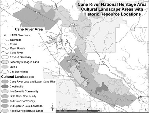 |
Figure 1. Selected data layers from Cane River National Heritage Area GIS show the locations of historic structures documented by HABS in relationship to cultural landscape boundaries and modern features. (Courtesy of CRGIS, National Park Service.) |
The ongoing work to add geo-referenced historic maps will allow users to expand their analysis of the landscape. Overlaying current tax parcel maps with 19th-century property boundaries, for instance, will help the heritage area locate significant historic resources within the modern landscape and target specific areas for protection. (Figure 2)
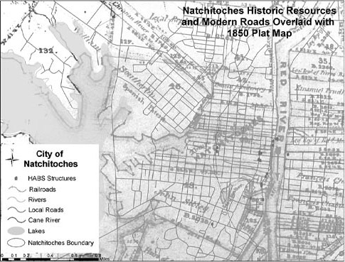 |
Figure 2. A geo-referenced 1850 plat map overlaid with modern features and historic structures illustrates key locations in the city of Natchitoches within the Cane River National Heritage Area. (Courtesy of CRGIS, National Park Service.) |
GIS will eventually provide a means for users to watch the landscape change from the 18th century to the present by overlaying data layers from different time periods. Using GIS to identify significant resources will promote the protection of sites within the heritage area. As the GIS data expands, the heritage area will be able to interpret the complex and important history of the region for the public. With GIS, resource managers can build on the HABS documentation, integrating it with other data sources and expanding the utility of the traditional paper-based products as a more responsive planning tool.
Historic Whitesbog, New Jersey
Building on the Cane River experience, CRGIS began a project in 2003 to document a historic cranberry bog in Whitesbog, New Jersey, as part of a HALS project on the evolution of cranberry cultivation practices and technology. The Whitesbog site represents one of the first commercial cranberry cultivation efforts in the United States, which spawned an important industry for the New Jersey economy. Standard HABS/HAER methods, including detailed measured drawings and photographs, could not adequately capture the complexity of such a large landscape. The addition of GPS and GIS to the documentation process added an entirely new aspect to the HALS documentation methodology.
Colonel James Fenwick began producing cranberries in the Whitesbog area as an experiment in the mid-19th century. Gradually, Fenwick transformed the property by constructing sophisticated canal systems and water control mechanisms to make the cranberry harvest successful. In the late 19th century, J. J. White took over the operation, expanding Whitesbog. White's machinery innovations brought technological advances to the sorting, packing, and storage of cranberries, as well as to the cultivation of the plants themselves, altering the entire landscape. In the mid-20th century, Thomas Darlington took over the business continuing the tradition of technological innovation by developing new harvesting and picking devices, further changing the landscape. Today, the state of New Jersey owns portions of the land that are still operated as cranberry bogs.
CRGIS captured the significant features of the current and historic landscapes to document the changing technology of cranberry cultivation and the resulting change in the highly engineered landscape. In cooperation with the Whitesbog Preservation Trust, CRGIS used GPS to map the critical engineering elements of the landscape as well as associated historic features. Focusing on the water movement needed to facilitate cranberry cultivation, the canals, ditches, sluice gates, dams, and bridges were located. Surveyors also collected information, such as the current condition and operational status of each feature, as well as its original period of construction. (Figure 3)
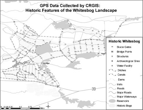 |
Figure 3. This view of the GPS data layers collected at Whitesbog documents the historic landscape features. (Courtesy of CRGIS, National Park Service.) |
Modern aerial photographs overlaid with GPS data proved invaluable in the GIS project. These images provide context for the cultivated areas, show the natural flow of water systems, and help to explain how the landscape functions as a whole. Historic aerial images oriented to the Earth, overlaid with modern images, help to fill in the development of the area, showing the locations of features that no longer exist. Similarly, overlaying the boundaries of the currently cultivated bogs with the historic images graphically illustrates the changes in bog construction resulting from changes in harvesting machinery. (Figure 4)
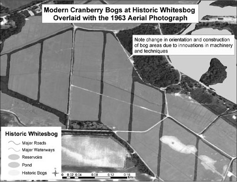 |
Figure 4. A geo-referenced 1963 aerial photograph overlaid with current cranberry bog features at Whitesbog illustrates changes in bog structure and harvesting technologies between 1963 and the present. (Courtesy of CRGIS, National Park Service.) |
In 2004, CRGIS is creating GIS tools to help the Whitesbog Preservation Trust display and interpret the Whitesbog landscape and technological innovations. Similar to the Cane River National Heritage Area project, the Whitesbog data will help with managing the historic features and landscape elements. Ultimately, the combination of GPS and GIS will provide HALS with new methods of documenting large landscapes.
World Guide to Covered Bridges
GIS may also serve as a new method to disseminate existing HABS/HAER/ HALS documentation to a wider audience through Internet mapping applications. In 2003, partnering with HAER, the Federal Highway Administration (FHA), and the National Society for the Preservation of Covered Bridges, CRGIS began a project to bring the HAER covered bridge documentation to the Internet through a web page offering interactive mapping capabilities. Based on the ongoing HAER covered bridges recording project, the project seeks to provide updated bridge conditions together with documentation in the HAER collection. The FHA will host a database containing the World Guide to Covered Bridges information and links to HAER documentation for the bridges through web-based GIS.
CRGIS will complete the conversion of the paper World Guide to Covered Bridges to an interactive web-based database in fall 2004. Combined with locational information gathered from existing sources and GPS, web page users will be able to search for specific bridges, update the information about each bridge, share photographs, and view maps.
GIS and GPS as Documentation Tools
As documentation tools, GIS and GPS provide perspective and context for historic preservationists who are considering all types of landscapes. As a communication tool, GIS supplies a means to make powerful, visual, and quantifiable presentations to the public and to those responsible for protecting cultural resources. Projects such as Cane River, Whitesbog, and the covered bridges show that using GPS improves the accuracy of cultural resource locational data and that GIS can serve as an instrument to ensure better cultural resource management. Additionally, the ability of GIS to integrate a variety of data and documents adds value to historic maps and traditional documentation. The flexibility of these tools allows preservationists to communicate more effectively, ultimately resulting in better protection of the nation's cultural heritage.
Taking advantage of these technologies opens the way for HABS/HAER/ HALS/CRGIS to document large resources yet preserve the details of each feature, visualize patterns over time, and explore different resources. Ultimately, GPS and GIS will enhance the utility of the entire HABS/HAER/ HALS/CRGIS collection and attract new audiences.
About the Author
Deidre McCarthy is a GIS specialist with the Cultural Resource Geographic Information Systems Facility, a component of the HABS/HAER/HALS/CRGIS Program. She can be reached at (202) 354-2141 or email deidre_mccarthy@nps.gov.