Canyonlands National ParkDecember 2025Superintendent's Compendium of designations, closures, permit requirements, and other restrictions imposed under discretionary authority. Approved by: Lena Pace, Superintendent, 5 December 2025 IntroductionThe Superintendent’s Compendium does not repeat regulations found in Title 36 Code of Federal Regulations (36 CFR), United States Code, and other CFR Titles, which are enforced without further elaboration at the park level. The Superintendent’s Compendium is the summary of park-specific rules implemented under 36 CFR. It serves as public notice, identifies areas closed for public use, provides a list of activities requiring either a special use permit or reservation, and elaborates on public use and resource protection regulations pertaining specifically to the administration of the park. The regulations contained in 36 CFR, Parts 1-7, are the basic mechanism used by the National Park Service (NPS) to preserve and protect the natural and cultural resources of the park and to protect visitors and property within the park. Parts 1 through 6 are general regulations applicable to all areas of the National Park System, and Part 7 contains special regulations specific to individual parks. Each of these parts has many sections and subsections articulating specific provisions. Within some of these Part 1-7 sections and subsections, the superintendent is granted discretionary authority to develop local rules to be responsive to the needs of a specific park resource or activity, park plan, program, and/or special needs of the general public. This compendium should be used in conjunction with Title 36 CFR, Parts 1-7, to more fully understand the regulations governing the use and enjoyment of all the areas of the National Park System. A copy of Title 36, CFR, can be purchased from the U.S. Government Printing Office or found on the internet at: https://www.ecfr.gov/cgi-bin/text-idx?tpl=/ecfrbrowse/Title36/36tab_02.tpl Laws and Policies Allowing the Superintendent to Develop This CompendiumThe National Park Service (NPS) is granted broad statutory authority under 54 United States Code (U.S.C.) Section 100101 et. seq. (Omnibus Public Land Management Act of 2009, previously Organic Act of 1916, as amended) to “…regulate the use of the National Park System by means and measures that conform to the fundamental purpose of the System units, which purpose is to conserve the scenery, natural and historic objects, and wild life in the System units and to provide for the enjoyment of the scenery, natural and historic objects, and wild life in such manner and by such means as will leave them unimpaired for the enjoyment of future generations.” [54 U.S.C. Section 100101(a)]. In 1970, Congress amended the NPS Organic Act to clarify its intentions as to the overall mission of the NPS. Through the General Authorities Act of 1970 (16 U.S.C. Sections 1a1-1a8),Congress brought all areas administered by the NPS into one National Park System and directed the NPS to manage all areas under its administration consistent with the Organic Act of 1916. In 1978, Congress amended the General Authorities Act of 1970 and reasserted system-wide the high standard of protection defined in the original Organic Act by stating “Congress further reaffirms, declares, and directs that the promotion and regulation of the various areas of the National Park System, as defined by Section 1 of this Title, shall be consistent with and founded in the purpose established by Section 1 of this Title, to the common benefit of all people of the United States.” 54 U.S.C. Section 100501 defines the National Park System as “… any area of land and water administered by the Secretary, acting through the Director, for park, monument, historic, parkway, recreational, or other purposes.” In addition to the above statutory authority, the superintendent is guided by established NPS policy as found in the NPS Management Policies (2006). The superintendent is also guided by more specific policies promulgated by the Director, National Park Service, in the form of Director’s Orders. As stated in the Management Policies, the primary responsibility of the NPS is to protect and preserve our national natural and cultural resources while providing for the enjoyment of these resources by visitor and other users, as long as use does not impair specific park resources or overall visitor experience. The appropriateness of any particular visitor use or recreational experience is resource-based and will vary from park to park; therefore, a use or activity that is appropriate in one park area may not be appropriate in another. The superintendent is directed to analyze overall park use and determine if any particular use is appropriate. Where conflict arises between use and resource protection, where the superintendent has a reasonable basis to believe a resource is or would become impaired, then that superintendent is obliged to place limitations on public use. Consistency of This Compendium with Applicable Federal Law and RequirementsThe Superintendent’s Compendium is not considered a significant rule requiring review by the Office of Management and Budget under Executive Order 12866. In addition, this Compendium will not have a significant economic effect on a number of small entities nor impose a significant cost on any local, state or tribal government or private organization, and therefore does not fall under the requirements of the Regulatory Flexibility Act or Unfunded Mandates Reform Act. The actions and requirements described in this Compendium are found to be categorically excluded from further compliance with the procedural requirements of the National Environmental Policy Act (NEPA) in Department of the Interior (DOI) Guidelines 516 DM 12 and as such, an Environmental Assessment will not be prepared. Development of the Requirements of the Superintendent’s CompendiumAs outlined above, the NPS has broad authority and responsibility to determine what types of uses and activities are appropriate in any particular National Park System area. The requirements of the Superintendent’s Compendium are developed through an analysis and determination process. The decision criteria used during this process are:
Applicability of the CompendiumThe rules contained in this compendium apply to all persons entering, using, visiting, orotherwise present on federally owned lands, including submerged lands, and waters administered by the NPS within the legislative boundaries of the park. This includes all waters subject to the jurisdiction of the United States, including all navigable waters. The rules contained in this compendium shall not be construed to prohibit administrative activities conducted by the National Park Service, or its agents, in accordance with approved general management and resource management plans, or in emergency operations involving threats to life, property, or park resources. Enforcement of Compendium RequirementsNPS Law Enforcement Park Rangers enforce the requirements of the United State Code, 36CFR, and this Superintendent’s Compendium. Penalties for Not Adhering to the Compendium RequirementsA person who violates any provision of the regulations found in 36 CFR, Parts 1- 7, orprovisions of this Compendium, is subject to a fine as provided by law (18 U.S.C. 3571) up to $5,000 for individuals and $10,000 for organizations, or by imprisonment not exceeding six months (18 U.S.C.3559), or both, and shall be adjudged to pay all court costs associated with any court proceedings. In addition, to any fines or imprisonment an individual may be subject to a period of probation not to exceed five years in length (18 USC 3561). Comments on the CompendiumThe compendium is reviewed annually and revised as necessary. The park welcomes commentsabout its program and activities at any time.Written comments on the Compendium may be submitted to: Superintendent Effective Date of the Superintendent CompendiumThe Superintendent’s Compendium is effective on the approval date listed on the first page of this document. Additional InformationSome of the terms used in this Compendium may have specific meaning defined in 36 CFR § 1.4 Definition 36 CFR 1.4 DefinitionsIn addition to definitions found in 36 CFR § 1.4(a), the following definitions, created by the superintendent, apply to all parts of this compendium for parkwide consistency: Aid Climbing is the direct use of a fixed or placed protection (pitons, nuts, bolts rivets, spring-loaded cams, etc.) to support a climber’s weight and assist in the climber’s ascent. In general, aid techniques are reserved for pitches where free climbing is difficult to impossible, and extremely steep and long routes. Most difficult aid climbs still require pitons or other techniques using a hammer. Canyoneering is defined as cross country travel involving descending into canyons or major rock formations using a variety of techniques that are associated with technical descents— those that require rappels and rope work, climbing or down-climbing, and/or swims. Free Climbing and Clean Aid Climbing are minimum impact approaches that employ chocks, stoppers, nuts, and camming devices, rather than pitons or bolts, for protection or direct support. These are climbing aids that are removable, do not damage or scar the rock, and do not become fixed after ascent. Geocaching is defined as the placement of a cache within the park boundaries and distributing the coordinates, or other clues to the coordinates, for the purpose of locating the cache at a later time. High Clearance Four-Wheel-Drive (4WD) Vehicle is a Jeep, sport utility vehicle (SUV), or truck type with at least 15-inch tire rims and at least 12 inches of clearance from the break over point (halfway between front and rear wheel hubs across the width of the vehicle). Four-wheel drive vehicles have a transfer case or differential that locks the front and rear drive shafts together when four-wheel drive is engaged and allows manual shifting of the entire gearset to low range. All-wheel-drive (AWD) vehicles do not meet this definition. Electric vehicles designed for off-road use will fit this definition if they offer advanced four-wheel-drive capabilities through independent electric motors at each wheel, or independent electric motors on front and rear axles capable of driving both adjoining axle shafts. Capabilities of electric vehicles must mimic the action of traditional 4x4 functionality in the absence of a conventional transfer case. Packraft is a lightweight, inflatable boat designed for backcountry travel, combining portability and durability for use in remote waterways. Made from reinforced materials like TPU-coated nylon, packrafts are compact enough to be carried with a backpack when deflated and, easily inflated at water’s edge for navigating flatwater and whitewater, and typically propelled using a breakdown paddle. Packraft brands include but are not limited to: Alpacka, Kokopelli, and NRS. Remotely piloted aircraft means a device that is used or intended to be used for flight in the air without the possibility of direct human intervention from within or on the device, and the associated operational elements and components that are required for the pilot or system operator in command to operate or control the device (such as cameras, sensors, communication links). This term includes all types of devices that meet this definition (e.g. model airplanes, quadcopters, drones) that are used for any purpose, including for recreation and commerce. Slacklining or Sling-lining is defined as walking on a rope or other line that is anchored between rock formations, trees, or any other natural features. Height of the rope above the ground is immaterial. Technical Rock Climbing is defined as ascending or descending a rock formation utilizing rock climbing equipment. Vessel, according to Utah Code 73-18-2 (19), means every type of watercraft, other than a seaplane on the water, used or capable of being used as a means of transportation on water. 36 CFR 1.5 Closures and Public Use LimitsWildlife ClosuresPlease reference Appendix A for wildlife closures. Determination: See Appendix A for closure justification. Filming, Still Photography, and Audio Recording Activity May Require a Permit, Consistent with 54 U.S.C. 100905.
Determination: Federal law at 54 U.S.C. 100905 states that permits and fees are not required for filming, still photography, or audio recording in park areas if certain requirements are met. These requirements address various topics, including, but not limited to, group size, location, equipment, potential impacts to resources and visitors, and the likelihood that the NPS will incur related administrative costs. If any of these requirements are not met, the law allows the Secretary of the Interior, acting through the NPS, to require a permit for the subject activity. Permit requirements are imposed by the superintendent under discretionary authority provided by 36CFR 1.5(a)(2), which allows the superintendent to impose conditions or restrictions on a use or activity, consistent with applicable legislation, to implement management responsibilities. The general regulations for permits in 36 CFR 1.6 do not apply to permits issued for filming, still photography, and audio recording, which instead are governed by the statutory provisions in 54 U.S.C. 100905. The imposition of permit requirements, on a case-by-case basis, for filming, still photography, or audio recording does not require rulemaking under 36CFR 1.5(b). Requiring a permit with reasonable terms and conditions in accordance with statutory requirements at 54 U.S.C. 100905 is not highly controversial, will not result in a significant alteration in the public use pattern of the System unit, will not adversely affect the System unit’s natural, aesthetic, scenic or cultural values, or require a long-term or significant modification in the resource management objectives of the System unit, because the permit requirement is limited in time and scope to the specific activities authorized by the permit, which contain terms and conditions that protect the values, resources, and visitors of the system unit, and implements federal law. Roads Closures and RestrictionsThe Needles DistrictThe following roads and parking areas are closed to all vehicle traffic or restricted as noted except for those on official government business:
Determination: The above closures and restrictions are to protect park infrastructure and ensure official government use only. The following roads require high clearance four-wheel drive:
Determination: Roads listed have been identified as challenging, quickly changing, and maintained to a standard of rugged or rough conditions and thus require a vehicle that meets the above definition to travel safely. Island in the Sky DistrictThe following roads and parking areas are closed to all vehicle traffic or restricted as noted except for those on official government business:
Determination: The above closures and restrictions are to protect park infrastructure and ensure official government use only. The following roads require high clearance four-wheel drive:
Determination: Roads listed have been identified as challenging, quickly changing, and maintained to a standard of rugged or rough conditions and thus require a vehicle that meets the above definition to travel safely. The Maze DistrictThe following roads and parking areas are closed to all vehicle traffic or restricted as noted except for those on official government business:
Determination: The above closures and restrictions are to protect park infrastructure and ensure official government use only. The following roads require high clearance four-wheel drive:
Determination: Roads listed have been identified as challenging, quickly changing, and maintained to a standard of rugged or rough conditions and thus require a vehicle that meets the above definition to travel safely. All park roads and lands are subject to temporary closures as indicated by signs or other means of notification during periods of adverse weather, natural disaster, emergency, or implementation of management responsibilities. Use Limits, Conditions, and RestrictionsThe following public use limits, conditions and restrictions are established within Canyonlands National Park: Island in the Sky District
Determination: The proximity of the campsites to the river corridor and the frequency of use by river users are the primary reason for designation.
Determination: The need to preserve the resource and visitor experience is best accomplished by limiting the total numbers of visitors to an area. Overcrowding, traffic, and noise pollution in the park are experiences we want to minimize to the greatest extent possible. The Needles District
Determination: This restriction is justified by the need to protect valuable natural resources, minimize human impact, and allow for ongoing research and conservation efforts. Damage to resources inside this area can cause irreversible damage, compromise scientific research, and/or create expense to the NPS or researching institutes. This closure will protect the integrity of research and the resources. Permitting Requirements
Determination: Managing access through permits helps prevent overcrowding, maintain the quality of visitor experiences, and promote responsible usage of backcountry areas. This also helps ensure the protection of sensitive habitats for desert bighorn sheep. The Maze District
Determination: By limiting access to specific areas and imposing group size restrictions, the park aims to minimize ecological damage, reduce visitor impact, and ensure the safety and enjoyment of all visitors while maintaining the integrity of sensitive ecosystems. River District
Determination: Upstream motorized travel poses significant dangers due to the steep gradient of the rapids and lack of visibility. By prohibiting this activity, the regulation aims to reduce the likelihood of accidents and injuries among boaters traveling downstream.
Determination: The restriction on caching boats and equipment for more than 24 hours ensures the safety and integrity of the natural environment while promoting responsible visitor behavior. Requiring pre-approval and specific labeling helps maintain order and accountability among users. Additionally, securing caches protects wildlife from human food sources, reduces litter and potential hazards, and ensures that sites remain accessible for all visitors, thereby preserving the park’s ecological balance and enhancing the overall visitor experience.
Determination: The requirement for river use permit holders to carry essential safety equipment is crucial for ensuring the well-being of all participants during river activities. This equipment prepares groups for emergencies, enhances safety protocols, and minimizes risks associated with outdoor activities. The stipulation that groups must travel together prevents fragmentation, ensuring that all members remain accounted for and can assist one another, which is vital for safety in remote areas. Limiting vessel size to 50 feet promotes navigational safety, reduces the risk of accidents, and helps protect the park's delicate ecosystems by preventing overcrowding and potential damage to natural resources. Together, these regulations foster a safer, more responsible recreational environment for all visitors.
Determination: The restriction on inboard vessels in Cataract Canyon is implemented to enhance safety and environmental protection. By allowing only rigid-hull inflatable boats with specific design features, the regulation ensures that vessels are capable of withstanding the challenging conditions of the canyon, thereby reducing the risk of capsizing or sinking. The requirement for sealed compartments enhances buoyancy and safety, providing a crucial layer of protection for occupants in the event of an emergency. Additionally, compliance with noise limits helps preserve the natural soundscape of the park, minimizing disturbances to wildlife and other visitors. These measures collectively contribute to a safer and more sustainable recreational experience in this sensitive area. Packrafts
Determination: This restriction allows for effective monitoring of river use and promotes responsible recreation, balancing safety with the practicality of lightweight, short-distance travel. Rock Climbing and CanyoneeringThe following closures, conditions, and restrictions apply to rock climbing or similar activities such as, but not limited to, technical rock climbing, free climbing and clean aid climbing within Canyonlands National Park: Closures
Conditions
RestrictionsClimbing and canyoneering within Canyonlands National Park shall be either free climbing or clean aid climbing, except as described below.
Determination: The restrictions on rock climbing and canyoneering in Canyonlands National Park are essential for preserving the park's natural and cultural resources while ensuring visitor safety. Closures prevent damage to sensitive features, such as arches and archaeological sites, while protecting the integrity of the landscape. Conditions allow for day-use activities without permits, promoting accessibility, while requiring permits for overnight use to manage backcountry impacts. Restrictions on climbing methods and equipment aim to minimize ecological disturbance and maintain the area's natural beauty. Prohibiting permanent anchors, altering rock surfaces, and using motorized tools ensures that climbing practices remain sustainable and respectful of the environment. These measures collectively safeguard the park's unique features and enhance the climbing experience for all visitors. Hang Gliders, BASE Jumping, Remotely Piloted Aerial VehiclesCanyonlands National Park is closed to the use of hang gliders, paragliders, and parachutes. BASE jumping is prohibited in Canyonlands National Park. 36 CFR 2.17 (a)(3); NPS Management Policies 2006, 8.2.2.7. Launching, landing, or operating remotely piloted aircraft from or on lands and waters administered by the National Park Service within the boundaries of Canyonlands National Park is prohibited except as approved in writing by the superintendent. 36 CFR 1.5 Determination: These restrictions are vital for ensuring visitor safety and protecting the park’s unique natural resources. The prohibition of these activities prevents potential accidents and injuries in an area known for its stunning but challenging landscapes. Additionally, the ban on remotely piloted aerial vehicles helps to maintain the park’s tranquility, protecting wildlife and minimizing disturbances to both natural and cultural resources. Allowing such activities could lead to negative environmental impacts, including disruption of wildlife habitats and potential damage to sensitive geological formations. By regulating these activities, the park preserves its pristine environment and enhances the visitor experience, ensuring that the beauty and integrity of Canyonlands National Park are safeguarded for future generations. Off-highway VehiclesVehicles are not permitted to be used off designated roads in Canyonlands National Park, as stated in 36 CFR 4.10(a) and (b). All motor vehicles operated within the boundaries of Canyonlands National Park must have a valid state registration as a “motor vehicle,” display a valid state license plate(s), and be operated by someone in possession of a valid state issued operator’s license. Motorcycles that are registered for road use are allowed. 36 CFR 4.2. Off highway vehicles, or OHVs, by definition are any motor vehicle designed primarily for off-road travel that is not licensed and registered for interstate travel. All-terrain vehicles (ATV)s, including street legal ATVs, sand rails, side-by-sides, and dune buggies, are examples of OHVs whose use is prohibited by 36 CFR 1.5. Determination: These restrictions are crucial for preserving Canyonlands National Park's delicate ecosystems and unique geological formations. By limiting vehicle use to designated roads, the regulations minimize soil erosion, protect native vegetation, and safeguard wildlife habitats. Ensuring all vehicles are properly registered and operated by licensed individuals promotes safety within the park Engine Idling and GeneratorsIdling running generators in the park is prohibited, with the following exceptions:
Idling the engines of motor vehicles is prohibited, with the following exceptions:
Determination: These restrictions aim to protect the natural environment and enhance visitor experiences by reducing noise pollution and air quality impacts. Designated BackcountryAll lands, including four-wheel-drive roads and the Shafer Trail below the Shafer day-use parking area, and waters within the boundaries of Canyonlands National Park are designated as backcountry with the following exceptions:
Determination: The designation of backcountry areas in Canyonlands National Park is vital for preserving the park's natural landscapes and promoting a wilderness experience for visitors. Backcountry refers to undeveloped and remote areas that offer opportunities for solitude, exploration, and connection with nature. By managing access to these areas, the park aims to protect sensitive ecosystems and cultural resources from the impacts of human activity. This approach encourages responsible recreation while maintaining the integrity of the park's unique environment. The careful delineation of backcountry boundaries ensures that visitors can enjoy the natural beauty and tranquility of the park, fostering a deeper appreciation for its wilderness character. Swimming and BathingThe following restrictions apply to all park lands:
Determination: These restrictions are designed to protect the park’s ecosystems and water quality. Allowing only biodegradable soaps at least 100 feet from water sources further safeguards aquatic habitats, while prohibiting the depletion of water sources ensures their sustainability within the park. Artificial Light SourcesThe use of artificial light sources for purposes other than personal route-finding or minimum impact camping—that is, to light up landscapes, rock formations, or other park features—is prohibited. Determination: This regulation helps maintain the park's pristine environment, reduces light pollution, and enhances the experience of visitors wishing to enjoy the natural beauty of the night sky and its celestial features. Fixed LinesThe use of fixed lines (any line made from any material which is stretched between two points) is prohibited except for tie-downs used in conjunction with tarps or tents affixed to ground stakes. This includes but is not limited to clothes lines, dog runs, hammocks or slack lines and prohibits attachment to vegetation, natural features, or government property. This regulation does not apply to recreational climbing. Determination: This regulation aims to prevent interference with wildlife habitats and minimize environmental impact while ensuring that the integrity of the park's landscapes is maintained. The prohibition also encourages visitors to engage with the natural environment responsibly, preserving the area's unique character and beauty. 36 CFR 1.6 Permits(c) Permits are required within Canyonlands National Park for the following (36 Code of Federal Regulations) activities:
Permits will be specific in nature to the activity being permitted. In those cases where permitted use is frequent, a specific permit form has been designed, i.e. backcountry use permit, entrance and campground fee permits and commercial filming permits. In most other cases, a special use permit or letter of authorization will be prepared which will articulate the specific conditions under which the permitted activity is authorized. In all cases, a permit or letter of authorization must be in the permittee’s possession at all times and must be presented to any authorized person upon request. Determination: These restrictions are essential for protecting natural resources, promoting visitor safety, and managing recreational impacts. By regulating activities such as camping, canyoneering, and some commercial operations, the permit system ensures compliance with guidelines that safeguard the park's ecosystem. 2.1 Preservation of Natural, Cultural and Archeological Resources(a)(4) Driftwood may be collected only in the following areas within the park for
Determination: The restriction on collecting driftwood in designated areas helps preserve ecological balance along riverbanks and protects wildlife habitats. By allowing collection only below high water lines, the regulation promotes sustainable practices for campfires while safeguarding the park's natural and cultural resources for future generations. 2.2 Wildlife Protection(d) In The Needles district: In The Maze district: Wildlife being transported through the park must meet all State of Utah Big Game Proclamation requirements pertaining to tagging and transporting of big game. Hunters must possess only weapons that meet the definition of “unloaded” during cross-park transport (36 CFR 1.4: “Bows, crossbows, spear guns or any implement capable of discharging a missile or similar device by means of a loading or discharging mechanism, when that loading or discharging mechanism is not charged or drawn.”). Firearms are exempt; state laws apply. Determination: The regulations governing wildlife transport and viewing in Canyonlands National Park are crucial for protecting wildlife and their habitats. Allowing hunters to transport legally taken game along specified routes minimizes disturbances to sensitive areas and ensures compliance with state regulations. 2.10 Camping and Food Storage(a) All overnight stays within Canyonlands National Park require a permit. Visitors must obtain either a backcountry use permit, a river use permit, or a front country campsite permit for designated areas such as The Needles Campground, Island in the Sky Campground, or the group campsites at Wooden Shoe, Dutch Oven, or Split Top. Frontcountry CampgroundsCamping in the designated frontcountry campgrounds within Canyonlands is permitted subject to the following requirements:
Determination: The restrictions in the front country campgrounds of Canyonlands National Park are vital for safeguarding natural resources, ensuring visitor safety, and preserving the park's fragile ecosystems. By regulating camping activities, including occupancy limits and food storage practices, the park reduces the likelihood of wildlife encounters and conflicts, promoting a harmonious relationship between visitors and the natural environment. These regulations encourage responsible camping behaviors, prevent environmental degradation, and help maintain the park's cleanliness and integrity for all guests. Furthermore, limiting the number of permits and occupancy levels effectively manages visitor impact, ensuring a sustainable experience while protecting the park's stunning landscapes and biodiversity for future generations. Group Campsites:The following conditions apply to the group campsites designated below:
Determination: These regulations are essential for protecting resources and enhancing visitor enjoyment. By limiting reservations to a maximum of seven days and allowing only two reservations per year per group, the park promotes equitable access and minimizes environmental impact. Additionally, setting clear capacities for group sites helps manage visitor numbers, reducing overcrowding and preserving the park's natural beauty while encouraging responsible camping practices. Backcountry Vehicle CampsitesCamping at the following designated backcountry areas is restricted to the maximum capacities per site. Camping with vehicles is restricted to designated sites by backcountry use permit only. Each site is identified by boundary posts defining the perimeters of the campsite area. Sleeping, cooking, and social activities must take place within the boundaries of the four posts. Checkout time is 10 am. Island in the Sky District Campsites
Needles District Campsites
Maze District Campsites
**Campsites in the Orange Cliffs Unit of Glen Canyon National Recreation Area. All others are in Canyonlands National Park. Groups larger than noted above must split up to meet the group size limits for the individual sites and camp in different campsites. Groups thus split must independently meet all requirements for overnight groups: separate permits with a different trip leader for each permit. Campsite reservations may be limited to a designated number of nights in order to allow maximum public access. When reservations are restricted during high use seasons, visitors may not extend their stays by remaining in the site under a different permit. Length of stay requirements apply to individuals, not just the permit holder. Determination: The regulations for camping in designated backcountry areas of Canyonlands National Park are vital for protecting natural resources and ensuring a quality experience for all visitors. By enforcing maximum site capacities and requiring camping with vehicles to occur only at designated sites, the park minimizes environmental impacts and preserves the integrity of the landscape. The requirement for activities to occur within clearly defined boundaries promotes responsible use and enhances safety. Additionally, splitting larger groups to comply with size limits ensures that more visitors can enjoy the backcountry, while restrictions on campsite reservations during peak seasons help manage demand and maintain access for all. These measures collectively foster a sustainable camping experience and protect the park's unique ecosystems. Roadless Areas CampingA roadless area is defined as a zone where designated backcountry sites do not exist. Requirements for roadless area camping are as follows:
Additionally:
Determination: The regulations for camping in roadless areas are essential for protecting natural and cultural resources and viewsheds while ensuring a positive visitor experience. By requiring camping to be at least one mile from roads and developed areas, as well as 300 feet from water sources and cultural sites, the park minimizes human impact on sensitive ecosystems. Encouraging use of previously disturbed areas helps preserve fragile habitats, while applying river regulations near the Green and Colorado rivers ensures safe practices. Group size limits promote responsible use, and restrictions on camping zones further protect the landscape. Overall, these measures foster sustainable camping and enhance the enjoyment of the park's natural beauty. Food Storage(d) In any paved campground or designated backcountry vehicle campsite, garbage must be disposed of in designated receptacles and may not be left in bags or other soft containers. Food must be stored in vehicles or hardened containers (with securing mechanisms in place) except when being prepared or consumed. Backpackers/cyclists/motorcyclists must store food and other scented items in such a way as to prevent access by wildlife. Canyonlands National Park adheres to Yosemite National Park's list of approved storage containers. The park may change this list at any time to ensure the protection of wildlife and visitors. See the Yosemite website for the current list. Needles district
Determination: The regulations regarding garbage and food storage are critical for protecting wildlife and ensuring visitor safety. In paved campgrounds and designated backcountry vehicle campsites, all garbage must be disposed of in designated receptacles, and food must be stored securely in vehicles or hard containers to prevent wildlife access. 2.11 PicnickingPicnicking shall be allowed in all areas except:
Garbage must be disposed of in designated receptacles and may not be left in bags or other soft containers. Food must be stored in vehicles or hardened containers (with securing mechanisms in place) except when being prepared or consumed. Determination: This restriction is essential for preserving cleanliness and safety while protecting natural resources. Requirements for proper garbage disposal and food storage help prevent wildlife disturbances, promoting responsible visitor behavior and enhancing the overall experience in the park. 2.13 FiresExcept during fire restrictions: (a)(1) Open wood fires are allowed only in the provided fire rings located within
Wood gathering is not allowed anywhere in the park, except as provided for river use permits. (See Use Limits, Conditions, and Restrictions under River District.) Cooking with charcoal is allowed at designated backcountry vehicle campsites. All charcoal and ash must be contained in a rigid and durable, hard sided fire pan or grill. Users must pack out fire pans or grills and all ash and charcoal. Backcountry users, subject to the terms of Canyonlands' Backcountry Management Plan and a backcountry use permit, are not permitted to have fires in the river corridor. Campfires by holders of river use permits are subject to the terms of the following:
For campfires on the river, only driftwood may be collected for firewood. Fire debris must be contained in a hard-sided fire pan at all times. All fire debris and ash must be packed out of the backcountry. Determination: These fire regulations help prevent wildfires, conserve natural habitats, and maintain the cleanliness of the environment. By permitting open wood fires only in designated fire rings and prohibiting wood gathering, the park ensures responsible management of fire-related activities and protects sensitive ecosystems. Allowing charcoal cooking at designated backcountry vehicle campsites, while requiring all ash and debris to be packed out, further promotes environmental stewardship. Additionally, restrictions on campfires in the river corridor and the use of only driftwood for fires help safeguard wildlife and preserve the park's natural resources. Conditions on Lighting or Maintaining a Fire
Determination: This action is necessary for the maintenance of public health and safety, protection of environmental or scenic values, protection of natural or cultural resources, and the implementation of management responsibilities. Materials other than approved combustibles—especially fire accelerants and substances prone to wind transport or explosion—creates serious risks when used to light or maintain fires. These combustibles can ignite or spread wildfires that directly threaten people and valuable resources and assets. The burning of manufactured or synthetic materials can contribute to air pollution, contaminate soil and water, and be toxic to humans and the environment. Less restrictive measures, such as an education campaign informing visitors of the risks of using certain materials to light or maintain a fire, would not be commensurate with the substantial risks associated with those activities and could lead to adverse outcomes that might be prevented by establishing an enforceable condition. 2.14 Sanitation and Refuse(b) Where toilet facilities are not provided, solid human waste including toilet paper must be containerized and carried out of the park by all boaters and backcountry users. Toilet systems must either (1) be the washable, reusable type allowing for the sanitary transfer of waste materials to septic vaults or sewage treatment facilities, or (2) use dry chemicals/enzymes to render solid human waste into nonhazardous products acceptable for disposal in permitted landfills. Chemically-treated human waste must be in hard-sided container(s) or puncture-resistant sealed dry bag(s) labelled ‘human waste.” Absorbent material, such as kitty litter, does not meet the standard listed above, and cannot be used.
Campers at these sites are required to carry out solid human waste in a portable toilet system outlined above. Determination: This restriction serves to protect public health, natural resources, and water quality. 2.15 Pets(a)(1) Pets are prohibited in any backcountry area, including within vehicles on designated backcountry roads, on any hiking trails, at any overlook, or any sidewalk or pathway leading to an overlook as defined on the Canyonlands brochure, or any river trip within the park, or in the Horseshoe Canyon unit of the park. The following exceptions apply:
(a)(3) Leaving a pet unattended is prohibited, except in the following circumstances:
(a)(5) Pet excrement must be immediately collected by the pet handler and disposed of in the nearest trash receptacle. Determination: These restrictions serve to protect park natural/cultural resources, wildlife, and visitors from the negative impacts of domestic animals. 2.16 Horses and Pack Animals(a) Animals designated as pack animals shall be limited to the following:
(b) Horse or pack animal use is allowed in the following designated areas only:
(g) The following conditions are established for use of horses or pack animals:
Determination: These restrictions serve to protect biological soil crust and other natural resources. Hiking trails and routes are not compatible with stock. 2.21 Smoking(a) Smoking and the use of electronic smoking devices is prohibited in all public use and administrative buildings and facilities, and in all government-owned or -leased vehicles. Determination: These restrictions are intended to protect public/employee health and government property from the effects of smoking and minimize the risk of fire/explosions in fuel storage areas. They also serve to minimize the risks of wildland fires during extreme weather conditions. 2.22 Property(a)(2) Park visitors may leave their vehicles unattended for the time period specified on their valid backcountry use permit. Caching water and food supplies for extended backcountry trips will be allowed with prior approval of the district ranger. Visitors wishing to cache supplies should submit a request with their request for a backcountry use permit. Traditional geocaches are prohibited. Virtual caches and waymarks within the park must be approved by the superintendent on a case-by-case basis to ensure they align with park management goals. This review process evaluates whether the virtual caches will impact park resources, disrupt visitor experiences, or interfere with the natural and cultural integrity of the area, thereby maintaining the tranquility and purpose of the park. Determination: These regulations prioritize the safety of visitors and the preservation of the park's natural resources. Allowing a specific timeframe for leaving vehicles unattended encourages responsible visitor behavior while ensuring compliance with backcountry camping permits. The decision to prohibit traditional geocaches is rooted in the need to protect sensitive ecosystems from disruption. Meanwhile, the requirement for superintendent approval of virtual caches ensures that any recreational activities align with the park’s objectives, maintaining the ecological balance and enhancing the overall visitor experience without compromising the park's integrity. 2.23 Recreation Fees(b) The following areas within Canyonlands National Park are designated recreation fee areas:
Frontcountry group and individual campsites are designated fee sites. Determination: Recreation fees in designated areas of Canyonlands National Park, including the Needles and Island in the Sky districts, are vital for funding park maintenance and conservation efforts. By designating front country group and individual campsites as fee sites, the park ensures the sustainability of facilities and resources, enhancing the visitor experience and preserving the park's unique landscapes for future generations. 2.35 Alcoholic Beverages and Controlled Substances(a)(3)(i) All public use buildings of the park are closed to the consumption of alcoholic beverages except during officially sanctioned activities when the building is closed to the general public. Determination: The consumption of alcoholic beverages is prohibited for public safety concerns and the orderly management of the facilities. 2.51 Public Assemblies, MeetingsLocations designated as “First Amendment” areas—that is, available for demonstrations, the sale or distribution of printed matter, and the free distribution of other message bearing items—are shown on the “First Amendment” maps attached to this document. Note: Gathering for the purpose of expressing views and making statements such as are protected under the First Amendment does not require a permit as long as the activity takes place in one of the designated "First Amendment" areas indicated in this document and the involved group is fewer than 25 people. Groups larger than 25 people need a permit. Printed matter, used as part of a "First Amendment" activity may be allowed in the "First Amendment" area without a permit for groups with fewer than 25 people. Determination: These restrictions are essential for balancing the rights of individuals to express their views with the need to protect park resources and maintain tranquility. Designating specific “First Amendment” areas ensures that activities such as demonstrations and the distribution of printed materials occur in locations that minimize potential conflicts with visitors and park operations. 2.62 MemorializationScattering of human ashes is allowed only in the locations as shown on the "Approved Areas for the Disposition of Cremated Remains" map attached to this document (Appendix C), pursuant to conditions of a special use permit issued by the superintendent. Determination: These restrictions are implemented to ensure respectful and environmentally responsible practices while preserving the park's natural and cultural resources. Allowing the scattering of ashes, under a special use permit, facilitates personal memorialization while minimizing impact on sensitive sites, such as archaeological locations and water sources. By prohibiting scattering in standing water and sensitive ecosystems, these measures protect the integrity of the park's landscapes and water quality, balancing personal memorialization with the need for environmental stewardship. 4.11 Load Weight and Size Limits(b)(1) Vehicles (or a combination of vehicles and trailers) which exceed 21 feet in overall length are prohibited from traveling on the Elephant Hill Access Road and the Elephant Hill Road system in The Needles district, and the Teapot Rock 4WD road north of the Teapot Rock Campsite in The Maze district. Determination: This restriction is crucial for ensuring safety and protecting the park's infrastructure. By prohibiting longer vehicles the park minimizes the risk of accidents and damage to narrow, rugged routes. This restriction also enhances the overall visitor experience by maintaining the integrity of these scenic roads, allowing for safer navigation and preserving the natural beauty of the landscape for all users. 4.21 Speed Limits(b) The speed limit on backcountry roads within the park is 15 miles per hour unless otherwise posted. Speed limits on paved roads within the park are as posted. Determination: This restriction aims to improve vehicle control on rugged backcountry roads, ensure the safety of visitors and wildlife, minimize noise pollution, and enhance the overall tranquility and experience of the park. 4.30 Bicycles(i)(1) Bicycles and Determination: The regulations permitting bicycles and electric bicycles on park roads is designed to enhance access while ensuring visitor safety. By allowing bicycles only in areas open to motor vehicles, the park can better manage traffic and reduce conflicts between users. AppendicesAppendix A: Designated Areas for First Amendment Activities
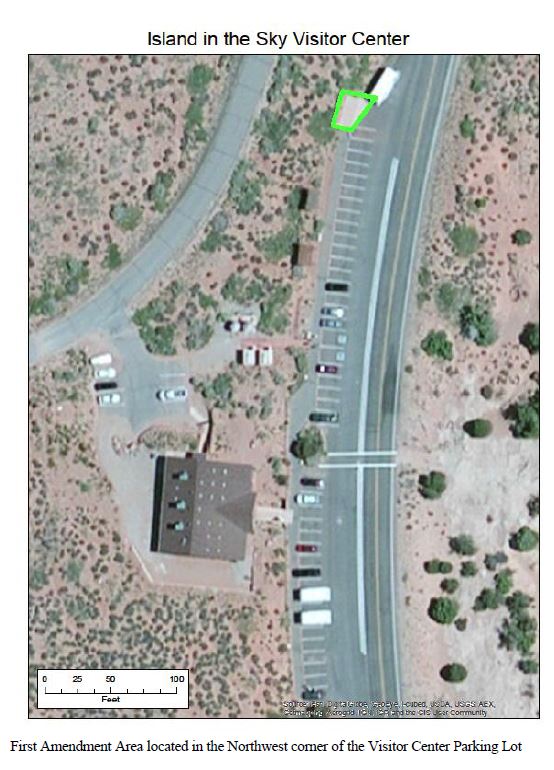
First Amendment Area: Island in the SkyThe First Amendment area is located in the northwest corner of the Island in the Sky Visitor Center parking lot. View a larger version of this image. 
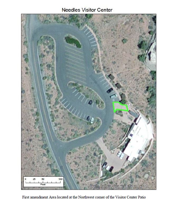
First Amendment Area: The NeedlesThe First Amendment area is located at the northwest corner of the Needles Visitor Center patio. View a larger version of this image. 
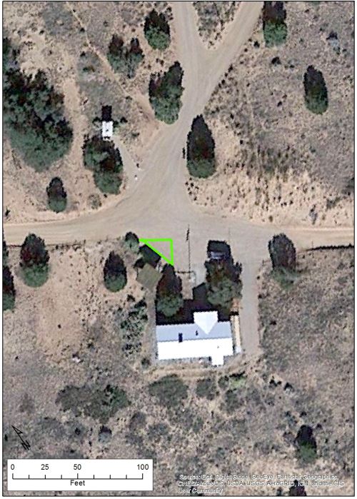
First Amendment Area: The Maze (Hans Flat)The First Amendment area is located at the northwest corner of Hans Flat Ranger Station's parking area. View a larger version of this image. 
Park MapTo view the roads of Canyonlands National Park, visit the Maps page, click "Park Tiles" in the upper left corner of the map viewer, then select "Brochure Map." Maps page Appendix B: Area Protection - WildlifeWildlife Closures
Climbing Area Closures for Wildlife ProtectionClosures to climbing routes will remain in effect through the end of the termination date specified below, or until surveys determine the associated habitat to be unoccupied by nesting raptors and/or lambing desert bighorn sheep.
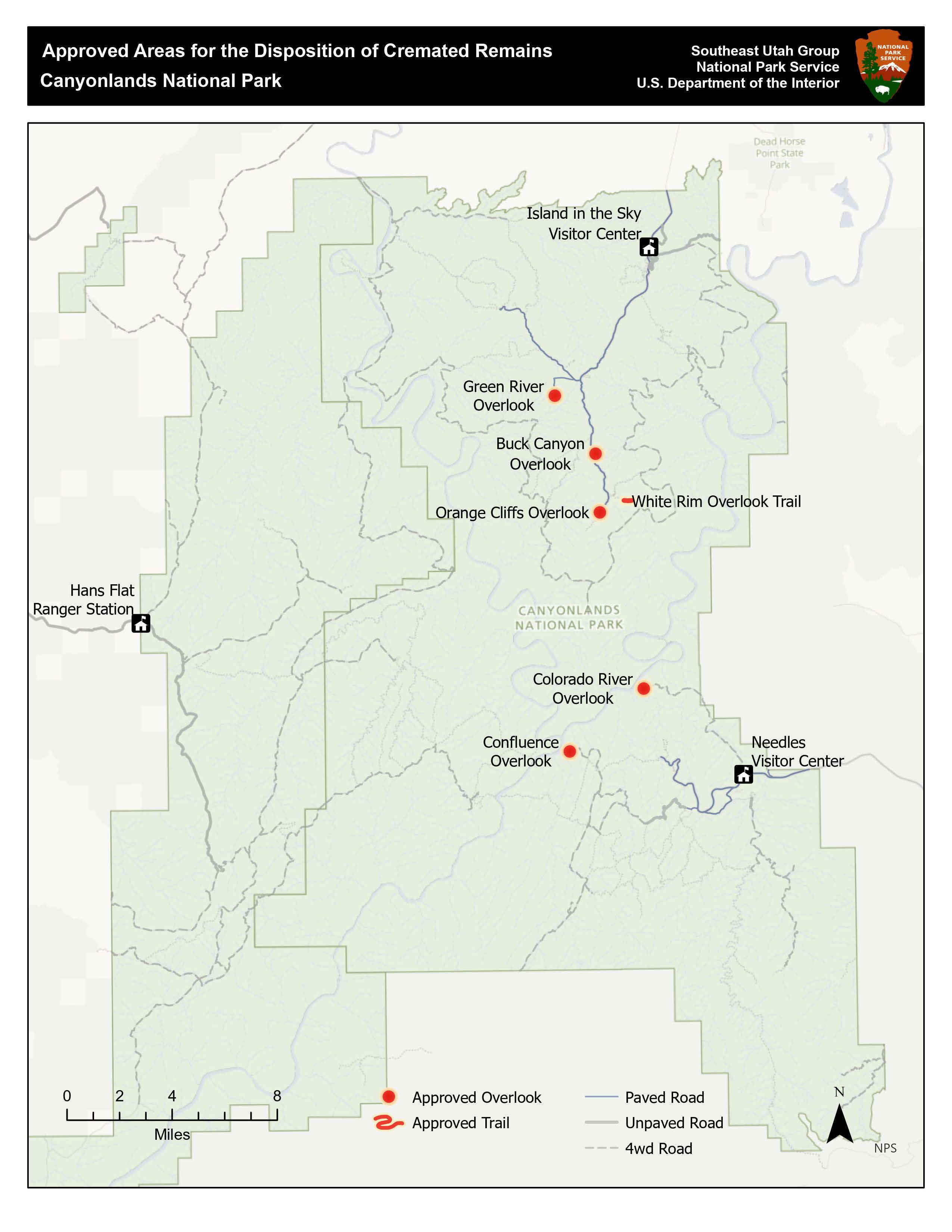
Appendix C: Approved Areas for the Disposition of Cremated RemainsView the map here. | |||||||||||||||||||||||||||||||||||||||||||||||||||||||||||||||||||||||||||||||||||||||||||||||||||||||||||||||||||||||||||||||||||||||||||||||||||||||||||||||||||||||||||||||||||||||||||||||||||||||||||||||||||||||||||||||||||||||||||||||||||||||||||||||||||

Last updated: February 24, 2026