
NPS photo/Jeff Rosenthal
The Superior Upland province is the southern extension of the Laurentian Upland province, part of the nucleus of North America called the Canadian Shield. The basement rocks of the Laurentian Upland province were metamorphosed about 2.5 billion years ago in a mountain-building collision of tectonic plates called the Kenoran orogeny.
The rocks of the Superior Upland are mostly Precambrian metamorphic rocks, and overlying Paleozoic rocks (Cambrian) covered by a thin veneer of glacial deposits left behind when glaciers melted at the end of the Pleistocene Ice Age.
The structure of Superior Upland rock is quite complex. Folds and faults, most dating back to Precambrian time, record several episodes of mountain-building. The plate collisions that formed the core of our continent left behind a striking structural trend. Ridges and valleys are strongly aligned along this northeast-southwest trend. Lake Superior is a splendid example of this structural trend. Ridges of erosion-resistant rock rise above valleys and carved into weaker rock units.
The Keweenaw Peninsula and Isle Royale are the site where a huge accumulation of lavas such as those that cover most of the oceans of the earth (flood basalts) are exposed at the surface. The lavas are the result of a rift which split North America and extended from Kansas to Ohio. At least 400 lava flows were erupted over a few million years, filling an expanding basin which now is occupied by Lake Superior. One of these lava flows ponded to a thickness of more than 1200 feet and formed a lava ocean that existed for more than 1000 years, one of the most voluminous known on earth. That lava flow now is exposed along the crest of both the Keweenaw Peninsula and at Blake Point, on the eastern end of Isle Royale.
The effects of repeated glaciation are visible on the Superior Upland. The present glacial topography is the product of the most recent glaciation that ended just 10,000 years ago. During the Late Wisconsin, the last glaciation of the Pleistocene Epoch, a massive continental ice sheet grew and gradually expanded southward. Several thick, finger-like lobes of glacial ice engulfed the region as they moved through the Superior basin. Rocks of all sizes were plucked and scoured from farther north and carried along by the icy mass. When the continental ice sheets melted, they left behind an assortment of rock called glacial drift that covers much of the Superior Upland landscape.
Educational Resources
- Keweenaw NHP Junior Ranger Program
The Keweenaw NHP Junior Ranger Booklet explores heritage, history, and geologic background at Keweenaw. - Isle Royale: Keweenaw Rift Geology
This field guide, by Bill Rose and Justin Olson at Michigan Technological University, aims at interpreting the geology at Isle Royale National Park.
Honey, I Shrunk the Glacier

NPS Photo
Honey, I Shrunk the Glacier is an on-line presentation that helps answer questions related to Michigan and glaciers. What would happen if you were to shrink a glacier? Learn about the landforms found in Michigan and the extent and retreat of the glaciers in the area. Source: S. E. Wilson, 2005.
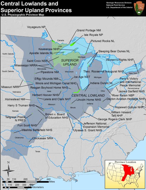
Superior Upland Parks
- Apostle Islands National Lakeshore, Wisconsin [Geodiversity Atlas] [Park Home]
- Grand Portage National Monument, Minnesota [Geodiversity Atlas] [Park Home]
- Isle Royale National Park, Michigan [Geodiversity Atlas] [Park Home]
- Keweenaw National Historical Park, Michigan [Geodiversity Atlas] [Park Home]
- Saint Croix National Scenic Riverway, Minnesota, Wisconsin [Geodiversity Atlas] [Park Home]
- Voyageurs National Park, Minnesota [Geodiversity Atlas] [Park Home]
Part of a series of articles titled Physiographic Provinces.
Previous: Rocky Mountain System Provinces
Last updated: May 1, 2018