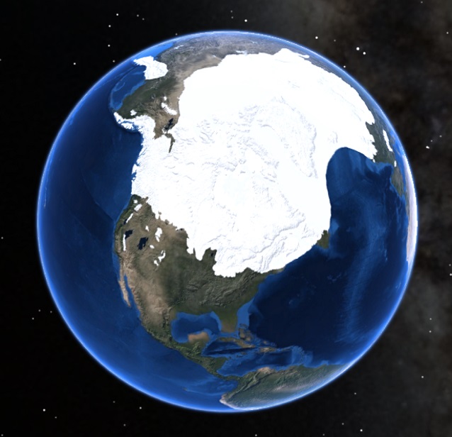
Courtesy of NOAA Science on a Sphere
Ice sheets are large, continental-scale (greater than 50,000 sq. km or 19,305 sq. mi in area) ice masses that accumulate in extensive, high elevation catchment areas. They are drained by smaller outlet glaciers or ice streams that flow out from them in different directions.
Today, the only ice sheets on Earth are the massive ice bodies in Antarctica and Greenland. However, during the last ice age (approximately 20,000 years ago), two ice sheets covered much of northern North America. These ice sheets shaped much of the landscape there, including a few of our parks.
Find Your Park: Which Parks Have Been Affected By Ice Sheets?
- Acadia National Park, Maine [Geodiversity Atlas] [Park Home]
- Apostle Islands National Lakeshore, Wisconsin [Geodiversity Atlas] [Park Home]
- Bering Land Bridge National Preserve, Alaska [Geodiversity Atlas] [Park Home]
- Cape Cod National Seashore, Massachusetts [Geodiversity Atlas] [Park Home]
- Glacier National Park, Montana [Geodiversity Atlas] [Park Home]
- Grand Portage National Monument, Minnesota [Geodiversity Atlas] [Park Home]
- Ice Age National Scenic Trail, Wisconsin [Geodiversity Atlas] [Park Home]
- Ice Age Floods National Geologic Trail, Washington, Oregon, Idaho, and Montana [Geodiversity Atlas] [Park Home]
- Pictured Rocks National Lakeshore, Michigan [Geodiversity Atlas] [Park Home]
- Voyageurs National Park, Minnesota [Geodiversity Atlas] [Park Home]
To learn more about glaciers, glacier features, and glacial landforms, see the Glaciers & Glacial Landforms Page.
Part of a series of articles titled Types of Glaciers.
Next: Ice Fields and Ice Caps
Last updated: November 19, 2018
