Last updated: April 17, 2023
Article
Volcanic Resources Summary—Lassen Volcanic National Park

NPS photo—Restrictions apply on use and/or reproduction.
Introduction
Lassen Volcanic Park contains a very diverse set of volcanic edifices, features and deposits produced through volcanic activity over the last three million years. The park includes four different types of volcanoes (volcanic dome, composite volcano, shield volcano, and cinder cone). It is also the most active volcanic area in the Cascade Range and three eruptions have occurred in the park during the Holocene, including the 1914-1917 eruption of Lassen Peak, which was the most recent eruption in the contiguous United States prior to the eruption of Mount St Helens in 1980. The Park also contains the largest and most diverse hydrothermal system in the Cascades.
Enabling Legislation
Lassen Volcanic NP -- 16 U.S.C. 201 -- 1907
-- "WHEREAS, Lassen Peak, which is situated upon public land in the State of California, within the Lassen Peak National Forest, marks the southern terminus of the long line of extinct volcanoes in the Cascade Range from which one of the greatest volcanic fields in the world extends, and is of special importance in tracing the history of the volcanic phenomena of that vicinity…
Now, therefore, I, Theodore Roosevelt … set apart … the Lassen Peak National Monument…” 35 Stat. 2132 (1907).
-- “That said park shall be under the exclusive control of the Secretary of the Interior, whose duty it shall be … to make and publish such rules and regulations…being primarily aimed at the freest use of the said park for recreation purposes by the public and for the preservation from injury or spoliation of all timber, mineral deposits, and natural curiosities or wonders within said park and their retention in their natural condition as far as practicable and for the preservation of the park in a state of nature so far as is consistent with the purposes of this Act. He shall provide against the wanton destruction of the fish and game found within said park and against their capture or destruction for purposes of merchandise or profit, and generally shall be authorized to take all such measures as shall be necessary to fully carry out the objects and purposes of this Act.” 39 Stat. 442, 444 (1916).
-- "The provisions of sections 1, 2, 3, 4, 201, 202, and 203 of this title and all Acts supplementary to and amendatory of said sections are made applicable to and extended over the lands added to the park by section 201a of this title . . . ."" 16 USC Sec. 201b (2006).
-- Secondary Source Information:
"All four types of volcanoes in the world are found in the park. Over 150 miles of trails and a culturally significant scenic highway provide access to volcanic wonders including steam vents, mudpots, boiling pools, volcanic peaks, and painted dunes."" http://www.nps.gov/lavo/index.htm
Park Purpose and Significance
[Excerpts from Lassen's Foundation Document]
Purpose
Lassen Volcanic National Park preserves dynamic volcanic phenomena, scenic values, outstanding wilderness character, and diverse natural and cultural resources; and provides educational, recreational, and exceptional scientific opportunities for the benefit of the public.
Significance
-
Few places on Earth parallel Lassen Volcanic National Park’s concentrated diversity of volcanic features. The park showcases a dynamic geologic landscape containing an intact network of hydrothermal features and 60 extinct and active volcanoes in relative proximity to one another that represent all four primary types: (1) shield, (2) composite, (3) cinder cone, and (4) plug dome. This extent and diversity is complemented by more than a century of scientific study, which enhances global knowledge of volcanic systems and contributes to future research, management, and stewardship.
-
Located at the crossroads of three distinct biological provinces—Cascades, Sierra Nevada, and Great Basin—Lassen Volcanic National Park preserves an exceptional biodiversity of more than 1,050 plant and animal species. This biologically rich transition zone offers many opportunities for scientists to research anthropogenic effects on biological processes and populations.
- Lassen Volcanic National Park protects valuable archeological sites, historic structures, objects, stories, and traditional places that remain significant to people of various backgrounds. These resources enrich our understanding of people that have lived in, adapted to, and traveled through the southern Cascade region for thousands of years.
- Lassen Volcanic National Park includes more than 90,000 acres of designated and proposed wilderness, which comprises more than 85% of park lands and are buffered by large expanses of other public lands and a contiguous wilderness area. The park’s wilderness lands provide outstanding opportunities to experience natural quiet, solitude, clean air, clear views, and pristine night skies amidst a distinctive, vast landscape of volcanic landforms.
Fundamental Resources and Values
[Excerpt from Lassen's Foundation Document]

Wide Variety of Volcanic and Hydrothermal Features and Associated Geology. With the iconic Lassen Peak towering above, Lassen Volcanic National Park contains approximately 170 square miles of volcanic landforms, glacially sculpted terrain, and spectacular hydrothermal features, all occurring at the southern tip of the volcanic Cascade Range. The park contains the four primary types of volcanoes (shield, composite, cinder cone, and plug dome), as well as lava flows, pyroclastic flows (density currents of volcanic gases, ash, and rock), and tephra (deposits of volcanic material ejected from a volcano). Before the eruption of Mount St. Helens in 1980, Lassen Peak was the only Cascade volcano to have erupted in the 20th century. The currently active “Lassen Volcanic Center” (a body of hot or molten rock beneath Lassen Peak) underlies most of the southern half of the park. This heat source of active volcanism drives the remarkable hydrothermal features, including roaring fumaroles, mudpots, boiling pools, and thermal ground. These features are indicators of the ongoing potential for future volcanic eruptions in the Lassen Volcanic Center. Although the park is noted primarily for its volcanic terrain and features, volcanism and glaciation have worked hand in hand in the creation of the park’s landscape. Large ice caps covered the mountainous terrain several times during ice ages of the recent geologic past. Glacial landforms, such as moraines and outwash deposits, overlay much of the volcanic foundation. The alteration of volcanic rocks by hydrothermal processes facilitated glacial erosion. Glacially eroded features such as cirques and aretes occur throughout the park. It should be noted that the prominent hydrothermal and glacial processes also highlight the importance of the park’s hydrology. The park lies in the headwaters of four major watersheds that all eventually drain to the Sacramento River, and contains over 200 lakes and ponds and 15 perennial streams. Groundwater systems are also fed by some closed basins near Lassen Peak that drain into lakes.
Volcanoes and Volcanic Landforms
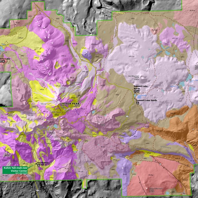
Lassen Volcanic NP includes many more volcanoes than just the three (Lassen Peak, Cinder Cone, and Chaos Crags) that erupted during the Holocene. At least 62 volcanic vents have been mapped in the park. Some of these vents produced volcanic domes, others cinder cones or shield volcanoes, and yet others erupted lava flows. The 3-million-year history of volcanism in Lassen Volcanic NP has produced one of the most diverse suite of volcanic landforms in any unit of the National Park System.
Volcanoes of Lassen Volcanic National Park
Four Types of Volcanoes

US Geological Survey photographs by Michael A. Clynne (upper and lower left) and Patrick Muffler (upper and lower right).
Location Maps

NPS image.
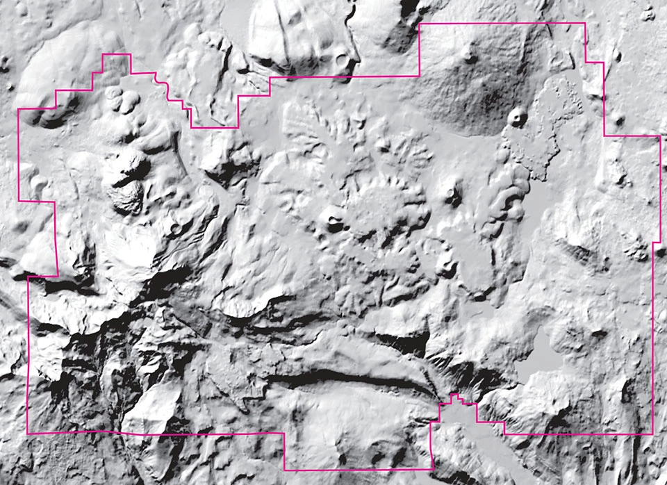

Left image
map view
Right image
map view with feature labels
Related Links
Lava Domes
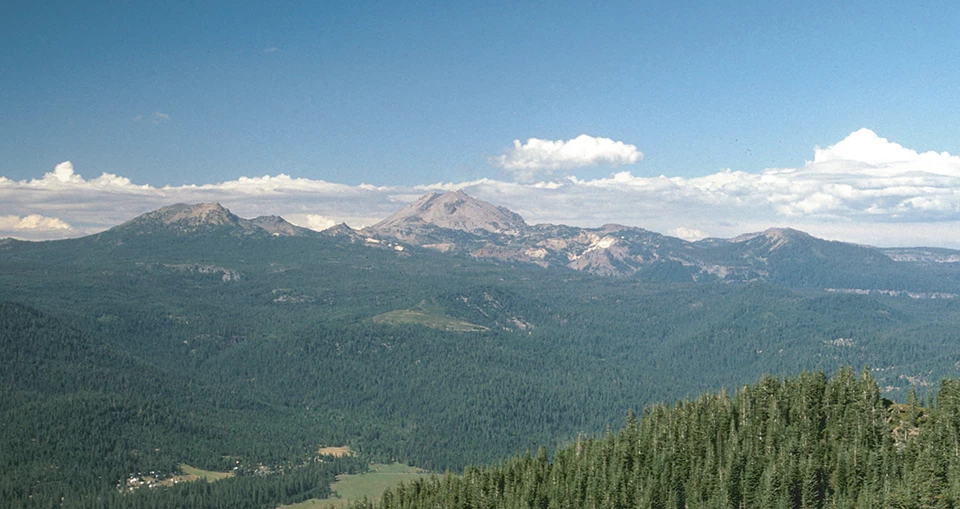
Lava domes form when gas-poor, dacite-to-rhyolite magma piles up over a vent because it is too viscous to flow away. More than any other type of volcano, lava domes characterize the Lassen landscape (Kane 1980). Lava domes have steep sides and come in a range of sizes. Lassen Peak began as a volcanic vent on Brokeoff Volcano’s northern flank and now rises 610 m (2,000 ft) from its base. Other lava domes in the park cluster around Lassen Peak and include the six domes at Chaos Crags, Crescent Crater, Reading Peak, Bumpass Mountain, Eagle Peak, Vulcans Castle, Loomis Peak, and the rhyodacite domes at Sunflower Flat.
Lassen Peak
Lassen Peak is the world’s largest dome with a peak elevation of 10,457 feet (3,187 m). It was emplaced 27,000 years ago.

John St. James flickr photo.
Chaos Crags
Chaos Crags are a set of six lava domes that grew during eruptions approximately 1,050 years ago.

John St. James flickr photo.
Related Links
Cinder Cones
Cinder cones dot the landscape in the park and are representative of regional volcanism. For example, Red Cinder Cone is a notable landmark on the eastern side of the park. The cone, marked by two vents, is geographically and geologically part of the Caribou volcanic field.
Although cinder cones typify regional volcanism, many of the cinder cones at the park are part of the Lassen domefield within the Lassen volcanic center, including Hat Mountain, Fairfield Peak, and Crater Butte. The most prominent cinder cone in the park is Cinder Cone. Cinder Cone is a major attraction and textbook example of this type of volcano (see photos below and top of page). It stands 215 m (700 ft) above its base and has a maximum diameter of 0.8 km (0.5 mi). Its summit crater is 72 m (240 ft) deep and 305 m (1,000 ft) across. across.
Cinder Cone
Lassen's Cinder Cone is a 700-foot-high cone of loose scoria. Scoria forms when blobs of gas-charged lava are thrown into the air during an eruption and cool in flight, falling as dark volcanic rock containing cavities created by trapped gas bubbles. The summit of Cinder Cone has a crater with a double rim, probably created by fluctuating eruptive activity late in its formation. The cone also has several associated blocky lava flows, and a related, widespread ash deposit identifiable for 8 to 10 miles from the cone.

NPS photo.
Related Links
Composite Volcano
Brokeoff Volcano (Mount Tehama) in Lassen Volcanic National Park is a deeply eroded large composite volcano. It consisted of lava domes, lava flows, and pyroclastic deposits that are between 590,000 and 385,000 years old. This volcano was eroded, primarily by glaciers, so that only remnants remain. The surviving portions of the central rim include Brokeoff Mountain, Mount Diller, Mount Conrad, and Pilot Pinnacle. During its heyday Brokeoff Volcano occupied the entire southwestern part of what is now Lassen Volcanic National Park and would have dominated the skyline. The volcano was an estimated 20 km (12 mi) in diameter and rose about 1,800 m (6,000 ft) above the landscape to an elevation of 3,300 m (11,000 ft) (Kane 1980).
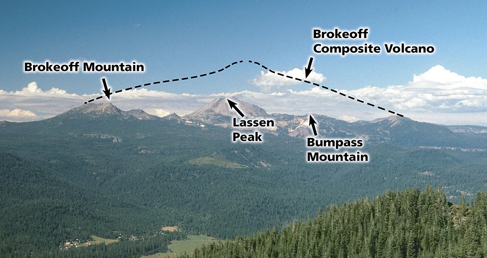
Left image
Brokeoff Volcano (Mount Tehama) in Lassen Volcanic National Park, California.
Credit: US Geological Survey photograph by Michael A. Clynne.
Right image
Projected profile of Brokeoff Volcano which would have risen to an elevation of 11,000 ft (3,300 m).
Credit: US Geological Survey photograph by Michael A. Clynne.
Related Links
Shield Volcano
Shield volcanoes are shaped like inverted warrior shields and form where mafic to intermediate (basalt to andesite) lava erupts effusively and flows far from a vent. The shield volcanoes at the park occur near the boundaries. Table Mountain and Prospect Peak are on the north. Sifford Mountain and Mount Harkness are on the south. Compared to Hawaiian shield volcanoes (the shield volcanoes in the park are small and have a variety of compositions (basalt, basaltic andesite, and andesite).

NPS photo by Glenn Kyler.


USGS image.

USGS image.

USGS image.
Related Links
Volcanic Centers
Five volcanic centers, sites or regios of long-lived, voluminous volcanic activity that erupt a range of compositions, occur in the park and vicinity: Latour, Yana, Dittmar, Maidu, and Lassen. Typically, a single volcanic center is active and becomes extinct before, or as, the next center begins. However, activity within the Maidu and Dittmar volcanic centers coincided.
|
Volcanic Center |
Age (years ago) |
|
Lassen Complex |
825,000–0 |
|
Maidu |
2.4–1.2 million |
|
Dittmar |
2.4–1.4 million |
|
Yana |
3.4–2.4 million |
|
Latour |
>3 million |
Source: Clynne and Muffler (2010)
Latour, active more than 3 million years ago
The Latour volcanic center is northwest of the park. It consisted of an andesite volcano and flanking silicic rocks similar to the other volcanic centers in the Lassen area. Latour Butte is a remnant of the larger volcanic center. Scientists know very little about the history of this particular volcanic center (Clynne and Muffler 2010).
Yana, active from 3.4 to 2.4 million years ago
The Yana volcanic center is south of the park, approximately 20 km (12 mi) southwest of Chester, California. Rocks of the Yana volcanic center dominate the area southwest of Lake Almanor. Butt Mountain, Ruffa Ridge, and Humboldt Peak are the major remnants of a deeply eroded andesitic composite volcano that was 15–20 km (24–32 mi) in diameter.
Dittmar, active from 2.4 to 1.4 million years ago
The Dittmar volcanic center is in the southeastern part of the park and centered in the upper Warner Creek valley just north of Kelly Mountain. The center has a diameter of about 20 km (12 mi). Saddle Mountain, Pilot Mountain, Kelly Mountain, and Mount Hoffman are the largest remnants of a deeply eroded andesitic composite volcano that once dominated this volcanic center.
Maidu, active from 2.4 to 1.2 million years ago
The Maidu volcanic center is southwest of the park in the area around Battle Creek Meadows near the town of Mineral, California. Lava flows (PLam) from the Maidu volcanic center underlie the park headquarters. The center was at least 25 km (15 mi) across. Hampton Butte and Turner Mountain are the largest remnants of the hydrothermally altered and deeply eroded andesitic composite volcano. Outcrops of the remnant volcano are well exposed in the canyon walls of Mill Creek. Early work by scientists suggested that the central depression (Battle Creek Meadows) was a caldera, but no evidence has been found to support this hypothesis (Wood and Kienle 1990).
Lassen Volcanic Complex
Lassen Peak, active from 825,000 years ago to the present
The Lassen volcanic center is the presently active volcanic center in the Lassen area. Clynne and Muffler (2010) designated the major stratigraphic divisions / eruptive stages of the Lassen volcanic center as the Rockland caldera complex, Brokeoff Volcano, and the Lassen domefield. Each stage is distinctive from the others, but all are linked by a common magmatic system (Clynne and Muffler 2010). Together they represent a continuum of volcanic activity over the past 825,000 years.
Brokeoff Volcano, 590,000 to 385,000 years ago
Soon after eruption of the Rockland tephra, the Rockland caldera began to fill as renewed activity formed Brokeoff Volcano—a large composite volcano with a volume of 80 km3 (19 mi3) (Clynne and Muffler 2010). Before hydrothermal alteration weakened and glacial advances eroded the volcano edifice, this mountain dominated what is now the southwestern part of Lassen Volcanic National Park. The summit rose to an elevation of 3,300 m (11,000 ft) (Kane 1980).
Clynne and Muffler (2010) divided the stratigraphy of Brokeoff Volcano into two sequences: Mill Canyon and Diller. The Mill Canyon sequence consists of lava flows erupted from a central vent between about 590,000 and 470,000 years ago; the vents, however, are not preserved (Clynne and Muffler 2010). The Diller sequence consists primarily of six voluminous, andesitic lava flows that erupted from vents on the flanks of Brokeoff Volcano between 470,000 and 385,000 years ago.
Lassen Domefield, 300,000 years ago to the present
The Lassen volcanic center was “quiet” from about 385,000 to 315,000 years ago. Then, the character and locus of volcanism changed dramatically—from the andesitic composite cone of Brokeoff Volcano to the Lassen domefield, which consists of a core of dacite domes surrounded by an arc of andesite and basaltic andesite flows. The domefield, which is focused in the northwestern corner of the park, became active about 300,000 years ago.
Dacite domes of the Lassen domefield erupted along the northern flank of Brokeoff Volcano and are divided on the basis of age into two sequences—the Bumpass and Eagle Peak. The 27,000-year-old dacite of Lassen Peak and the 1,050-year-old rhyodacites of Chaos Crags are part of the Eagle Peak sequence.
The andesite and basaltic andesite flows that form an arc around the dacite domes erupted in two groups—the older Twin Lakes sequence and the younger Twin Lakes sequence. The older Twin Lakes sequence is contemporaneous with the Bumpass sequence (of dacite domes). The andesite lava flows are much younger than the underlying rhyolite of Raker Peak. The andesite formed a lava cone with agglutinate scoria at the vent.
The younger Twin Lakes sequence (approximately the past 90,000 years) is contemporaneous with the Eagle Peak sequence (of dacite domes). Cinder Cone and the summit eruptions of Lassen Peak are part of the younger Twin Lakes sequence.
The Lassen domefield was apparently “quiet” for 100,000 years between 190,000 and 90,000 years ago (Clynne and Muffler 2010).
Related Links
Holocene Eruptions
The Lassen Volcanic Center is still active, and three eruptions of Holocene age have occurred: Chaos Crags, Cinder Cone, and the 1914–1917 eruption at the summit of Lassen Peak. Chaos Crags is part of the Eagle Peak sequence; Cinder Cone and the eruption at the summit of Lassen Peak are part of the younger Twin Lakes sequence. No other eruptions documented to be Holocene have occurred in the Lassen region. (USGS)
Lassen Peak
1914-1917 EruptionCinder Cone
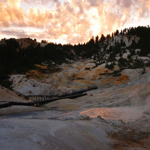
Hydrothermal Features
The Lassen volcanic center hosts far and away the most extensive hydrothermal system in the Cascade arc (Clynne et al. 2012). Lassen Volcanic National Park contains the surface manifestation of the Lassen hydrothermal system at (listed in order of size, table below) Little Hot Springs Valley, Sulphur Works, Bumpass Hell (fig. 15), Devils Kitchen (fig. 16), Boiling Springs Lake (fig. 17), Drakesbad, Pilot Pinnacle, and Terminal Geyser (fig. 18). These areas contain many thermal vents that form superheated fumaroles from which gases are emitted (fig. 19), hot springs where water temperatures are higher than that of the human body, mud pots that range in temperature from boiling to near ambient (fig. 20), and warm to hot ground commonly covered with orange and yellow sulfates. In addition, the slow seepage of cold CO2—one of the prominent gases emitted from the system—occurs beneath water in a few places and causes bubbling in Soda Lake and Cold Boiling Lake (Kane 1980). Extensive areas of hydrothermally altered rocks are a further surface expression of hydrothermal activity and indicate that the hydrothermal system moves around with time.
The boiling point of water varies with elevation but in general is about 95°C (203°F) at the park. Measured temperatures of hot springs range from 52°C to 97°C (126°F to 207°F) in the Lassen area (Clynne et al. 2003). Fumaroles have temperatures as high as 161°C (322°F) at Bumpass Hell, notably Big Boiler (fig. 21; Truesdell et al. 1983), and 147°C (297°F) at Little Hot Springs Valley (Janik and Bergfeld 2010).
The vigor of Lassen’s hydrothermal features varies from season to season and year to year. In spring, when cool groundwater from snowmelt is abundant, the fumaroles and pools have lower temperatures, and mud pots are more fluid. In late summer and in drought years, the features become drier and hotter because less mixing occurs with shallow, cool groundwater. On a longer time scale, hydrothermal features may shift position, die out, or evolve into different types of features (see “Hydrothermal Hazards” section). For example, an area of steaming ground in upper Sulphur Works collapsed in the early 1980s, forming a huge, boiling mud pot (Clynne et al. 2003).
Hydrothermal areas in Lassen Volcanic National Park
|
Name |
Size |
|
Little Hot Springs Valley |
79,000 m2 (850,000 ft2) |
|
Sulphur Works |
58,000 m2 (624,000 ft2) |
|
Bumpass Hell |
46,000 m2 (495,000 ft2) |
|
Devils Kitchen |
40,900 m2 (440,000 ft2) |
|
Boiling Springs Lake |
14,300 m2 (154,000 ft2) |
|
Drakesbad |
10,000 m2 (108,000 ft2) |
|
Pilot Pinnacle thermal area |
7,500 m2 (80,700 ft2) |
|
Terminal Geyser |
900 m2 (9,700 ft2) |
Source: Sorey and Colvard (1994).
Geologic Resources Inventory—Lassen
USGS—California Volcano Observatory
NPS
-
Lassen Volcanic National Park (LAVO), California—[LAVO Geodiversity Atlas] [LAVO Park Home] [LAVO npshistory.com]