Texas
Parks
-
National Monument
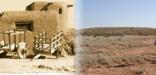
Alibates Flint Quarries
Fritch, TX
13,000 years ago, Alibates Flint was used by mammoth hunters as a source of flint for tools. Learn how important this site was to the survival, commerce, and culture of the people of the High Plains.
-
National Recreation Area
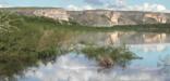
Amistad
Del Rio, TX
An oasis in the desert, Amistad National Recreation Area consists of the US portion of the International Amistad Reservoir. Amistad, a Spanish word meaning "friendship," is known for excellent water-based recreation, camping, hiking, and rich cultural history dating back nearly 5,000 years. Amistad is also home to a wide variety of plant and animal life both above and below the water.
-
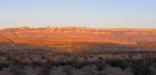
National Park
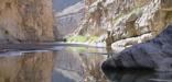
Big Bend
The big bend of the Rio Grande, TX
There is a place in Far West Texas where night skies are dark as coal and rivers carve temple-like canyons in ancient limestone. Here, at the end of the road, hundreds of bird species take refuge in a solitary mountain range surrounded by weather-beaten desert. Tenacious cactus bloom in sublime southwestern sun, and species diversity is the best in the country. This magical place is Big Bend...
-
National Preserve
Big Thicket
Beaumont, TX
Life of all types abounds in the Big Thicket. This national preserve protects the incredible diversity of life found where multiple habitats meet in southeast Texas. Hiking trails and waterways meander through nine different ecosystems, from longleaf pine forests to cypress-lined bayous. It is a place of discovery, a place to wander and explore, a place to marvel at the richness of nature.
-
National Historic Site
Blackwell School
TX
Written by prejudice rather than law, the story of the Blackwell School is one of “separate but equal” education for Mexican and Mexican American citizens of Marfa, Texas. Built in 1909, the school serves as a significant example of how racism and cultural disparity dominated education and social systems in the United States during this period of de facto segregation from 1889-1965.
-
National Historic Trail
Butterfield Overland
MO, AR, OK, TX, NM, AZ, CA
In 1857, businessman and transportation entrepreneur John Butterfield was awarded a contract to establish an overland mail route between the eastern United States and growing populations in the Far West. What became known as the Butterfield Overland Trail made an arcing sweep across the southern rim of the country. Stagecoaches left twice a week carrying passengers, freight, and mail.
-
National Memorial
Chamizal
El Paso, TX
Chamizal is more than just an urban park to recreate or enjoy a quiet afternoon. These grounds are a reminder of the harmonious settlement of a 100-year boundary dispute between the United States and Mexico. We celebrate the cultures of the borderlands to promote the same mutual respect that helped to diplomatically resolve an international disagreement.
-
National Historic Trail
El Camino Real de los Tejas
Various States TX,LA
Explore a diverse array of histories contained within El Camino Real de los Tejas’ 150-year life, including the Spanish struggle to missionize American Indian nations, the growth of cattle ranching in the Mexican period, and the movement for Texan independence and statehood.
-
National Historic Trail
El Camino Real de Tierra Adentro
NM,TX
Travel along El Camino Real de Tierra Adentro National Historic Trail to experience and learn from a complicated legacy of 300 years of conflict, cooperation, and cultural exchange between a variety of empires—European and non-European alike.
-
National Historic Site
Fort Davis
Fort Davis, TX
Fort Davis is one of the best surviving examples of an Indian Wars' frontier military post in the Southwest. From 1854 to 1891, Fort Davis was strategically located to protect emigrants, mail coaches, and freight wagons on the Trans-Pecos portion of the San Antonio-El Paso Road and on the Chihuahua Trail.
-
National Park
Guadalupe Mountains
Salt Flat, TX
Come experience mountains and canyons, desert and dunes, night skies and spectacular vistas within a place unlike any other. Guadalupe Mountains National Park protects the world's most extensive Permian fossil reef, the four highest peaks in Texas, an environmentally diverse collection of flora and fauna, and the stories of lives shaped through conflict, cooperation and survival.
-
National Recreation Area
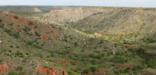
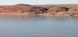
Lake Meredith
Fritch, TX
Set within the wide-open Texas Plains, Lake Meredith National Recreation Area offers a peaceful retreat in the heart of rugged grasslands. Over thousands of years, the Canadian River carved dramatic 200-foot canyons—known as breaks—that now frame the lake in striking layers of color and texture. These quiet coves sustain an unexpectedly rich array of life, providing seven distinct habitats.
-
National Historical Park
Lyndon B Johnson
Johnson City, TX
Lyndon B. Johnson National Historical Park tells the story of our 36th president beginning with his ancestors until his final resting place on his beloved LBJ Ranch. This entire "circle of life" gives the visitor a unique perspective into one of America's most noteworthy citizens by providing the most complete picture of any American president.
-
National Seashore
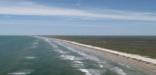
Padre Island
Corpus Christi, TX
Protecting sixty-six miles of wild coastline along the Gulf of America, the narrow barrier island is home to one of the last intact coastal prairie habitats in the United States. Along the hypersaline Laguna Madre, tidal mud flats teem with life. Native Americans, Spanish explorers and cattle ranchers have walked along its shores. Padre Island National Seashore is waiting to be rediscovered.
-
National Historical Park
Palo Alto Battlefield
Brownsville, TX
On May 8, 1846, U.S. and Mexican troops clashed on the prairie of Palo Alto. The battle was the first in a two-year long war that changed the map of North America. Although the two countries have developed strong bonds and friendly ties since the war ended in 1848, these neighbors continue to contend with the legacy of the war.
-
Wild & Scenic River
Rio Grande
Southwest Texas, TX
For 196 miles, this free-flowing stretch of the Rio Grande winds its way through desert expanses and stunning canyons of stratified rock. For the well prepared, an extended float trip provides opportunities to explore the most remote corner of Texas and experience the ultimate in solitude, self-reliance, and immersion in natural soundscapes.
-
National Historical Park
San Antonio Missions
San Antonio, TX
Welcome to San Antonio Missions, a National Park Service site and the only UNESCO World Heritage Site in Texas. Each mission in the park is a center of community and has been since the early 1700s. They changed life in this region, introducing new technologies while enforcing new cultural guidelines. As you visit, reflect on change, culture, power, and how people have used the land.
-
National Monument
Waco Mammoth
Waco, TX
Standing as tall as 14 feet and weighing 20,000 pounds, Columbian mammoths roamed across what is present-day Texas thousands of years ago. Today, the fossil specimens represent the nation's first and only recorded evidence of a nursery herd of ice age Columbian mammoths.


By The Numbers
- 14 National Parks
- 5,230,385 Visitors to National Parks
- $562,000,000 Economic Benefit from National Park Tourism »
- $229,537,550 of Land & Water Conservation Fund Appropriated for Projects (since 1965) »
- 77 Certified Local Governments »
- 166 Community Conservation & Recreation Projects (since 1987) »
- 1 Wild & Scenic Rivers Managed by NPS »
- 2 National Trails Administered by NPS »
- 3,468 National Register of Historic Places Listings »
- 47 National Historic Landmarks »
- 20 National Natural Landmarks »
- 1 World Heritage Site »
- 1,125 Places Recorded by Heritage Documentation Programs »
- 5,717,172 Objects in National Park Museum Collections »
- 3,866 Archeological Sites in National Parks »
- 5 Teaching with Historic Places Lesson Plans »
- 12 Discover Our Shared Heritage Travel Itineraries »
 Print the summary »
These numbers are just a sample of the National Park Service's work. Figures are for the fiscal year that ended 9/30/2020.