



“I have a little transparency of Fishing Cone pasted on my office window, but one has to be careful how he strains the credulity of visitors who happen to see it and inquire. Didn’t honest John Colter lose his reputation after he came back from the Lewis and Clark expedition and described what he saw in the Park?”
In early 1911, Christopher E. Sherman, Associate Professor of Civil Engineering at The Ohio State University, sat down and wrote a letter. Though addressed to no one specifically, Professor Sherman had a particular group of men in mind as he wrote. To this group of men, he penned a missive overflowing with poetry and warm memories of the summer of 1905, when “thirty-two students and four instructors left on the Pacific express, to survey the stage roads for Uncle Sam in the Yellowstone National Park.” (1)
For four weeks in the summer of 1905, 36 students and faculty members from the Civil Engineering Department at The Ohio State University surveyed and mapped 42 miles of roads in Yellowstone. They undertook this task in order to “furnish accurate maps of the well-known stage routes, showing the natural wonders of interest to the tourist, and the details of construction for purposes of administration.” At the time, the roads system in Yellowstone was administered by the United States Army Corps of Engineers. The senior engineer in charge at the Corps of Engineer’s Office in Yellowstone was Major Hiram M. Chittenden. Chittenden was also the man who gave Professor Sherman, his colleagues, and their students at Ohio State the opportunity to work in Yellowstone that summer. (2)
“Up with the morning at early light, away with transit and pole and chain, angles and metes and bounds are plain, elastic the step and clear the brain, out in the open air. Who is it that does not wish he might be surveyor out in the hills, running the line where cuts and fills may follow his wake after the ills of the routes are all laid bare?”
Professor Sherman and Major Chittenden first formed a working relationship in the 1890s. In November 1894, Chittenden and Sherman both began working on a survey of possible canal routes between Lake Erie and the Ohio River. Chittenden, who had the rank of Captain at the time, was named the executive officer of the project and supervised Sherman, who oversaw drafting work. After working together for more than a year, they went their separate ways in 1896. They met again in 1899 when Chittenden was assigned the position of engineering officer in Yellowstone for a second time. (3)
Chittenden first served in Yellowstone from 1891-1893, so he was already familiar with the unique challenges he would face as the engineering officer in the world’s first national park. Thus, when he returned in 1899, he knew he needed educated and skilled engineers to work on the road improvement projects throughout the park. He knew he needed engineers like Christopher Sherman.
In the spring of 1899, Sherman had been employed as a professor in the Civil Engineering Department at his alma mater for almost three years. While he spent the school year educating future engineers, he looked for other ways to occupy his time during the summer. Sherman first attempted to spend a summer on a survey crew in Yellowstone in 1897. In letters written in December 1986 and May 1987, Acting Superintendent George Anderson informed Sherman that the meager road improvement funds appropriated by Congress would not be able to support survey crews in the park that summer. Sherman was undoubtedly disappointed, but he got his opportunity to work in Yellowstone when his former supervisor returned to work in the park. (4)
In the summers of 1899 and 1900, Sherman worked under Chittenden as a United States Assistant Engineer on Roads & Bridges. During those two summers, the road crews under Chittenden’s direction began surveying possible routes for roads to connect Canyon and Tower Falls, Mammoth and Tower Falls, and Lake and the eastern park boundary. They also began work on a new three mile section of road between Golden Gate and Mammoth that Acting Superintendent Oscar J. Brown described as “the best piece of road building in the park.” Although the true nature of Sherman and Chittenden’s working relationship during this period is not known, the two must have worked amiably together, since, in 1905, Chittenden arranged a truly unique summer school session for Sherman, Sherman’s colleagues, and their students from the Civil Engineering Department at Ohio State. (5)
“The tourist does not see the country. What does he know about the life of the land thru which he rides? The surveyor plats the rocks and trees, the brooks he knows, and the lakes and ponds…These are his friends after they are measured and known, and in after years the toil is forgotten and all he recalls are the well known cliffs and waterfalls where once he was at home. He would like to see them again.”
As instructor in charge of the summer session, Sherman established and maintained a survey headquarters at Mammoth once the Ohio State group arrived in Yellowstone in the summer of 1905. The students were split into three survey parties. The other three instructors each supervised one of the student survey parties. (6)
Party number one was led by Assistant K.B. Ward and surveyed 19 miles of road between Gardiner, Montana and Norris Geyser Basin. Before they worked their way out of Gardiner, they first completed a station survey for the Northern Pacific Railroad at Gardiner. As he compared the experiences of tourists and surveyors in Yellowstone in his 1911 letter, Sherman wrote, “What does the tourist know of brook trout? Ask Ward’s men, they knew the places in Gardiner River where trout would bite on grasshoppers. Beside the road where the tourists fish …the trout are too smart to bite. Strange how knowing are trout.”
The second survey party worked the road from Mammoth to Tower Falls, surveying under Professor F.H. Eno. In another comparison in his 1911 letter, Sherman wondered, “What about bears? The tourist sees bears – out on the garbage heap at the hotels…didn’t they steal the bread one night from Eno’s camp? What is it to see bears out back of hotels, compared with having them scratch on your tent at night?”
Survey party number three worked under Assistant Professor J.R. Chamberlin and surveyed the road from Norris Geyser Basin to the junction at Canyon. They also surveyed six miles of the road north out of Norris to fill in a gap left by party number one. In 1911, Sherman asked, “What does the tourist see riding on train or stage? What does he know about mosquitoes? …Ask Chamberlin’s men about mosquitoes; they surveyed from Norris to Canyon.”
“So close to nature and close to truth…”
After four weeks and 42 miles of road, the surveyors became the tourists. The government rewarded each survey party with a weeklong trip into the portions of the park they had not already seen. Then, the group from Ohio State boarded the specially chartered train cars on which they had arrived and returned home. In Sherman’s words, “Needless to say the work of this session was most instructive and engaging…and the memories of the trip will always linger in the minds of those who made it.” (7)
“A surveyor’s life is the life for me, across the plains or over the lea, through the woods past rock and tree, wherever the line may run. Out in the mountain’s bracing air, far from the city with all its care, living in tents on hardy fare, hard work is only fun.”
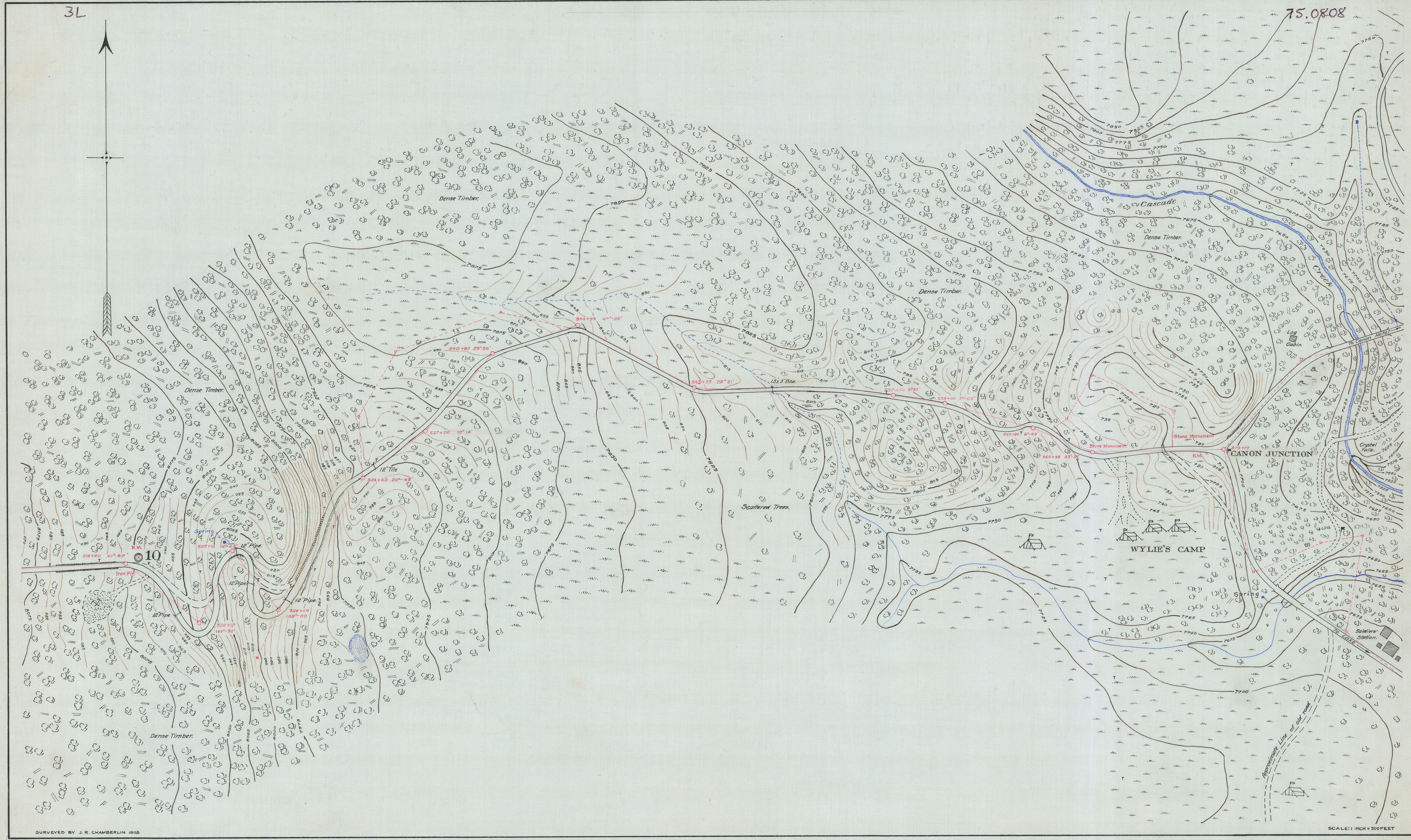 Cropped scan of Yellowstone National Park Road Surveys map made under the direction of Major H.M. Chittenden, Corps of Engineers, by the Civil Engineering Department of Ohio State University: Norris Basin to Cañon [Canyon] Junction, 1905, YELL145676-M599m, found in RG Maps: Maps & Drawings Collection, Series I: Army Era, Subseries 2: Roads, Folder 8, National Archives-Yellowstone National Park.
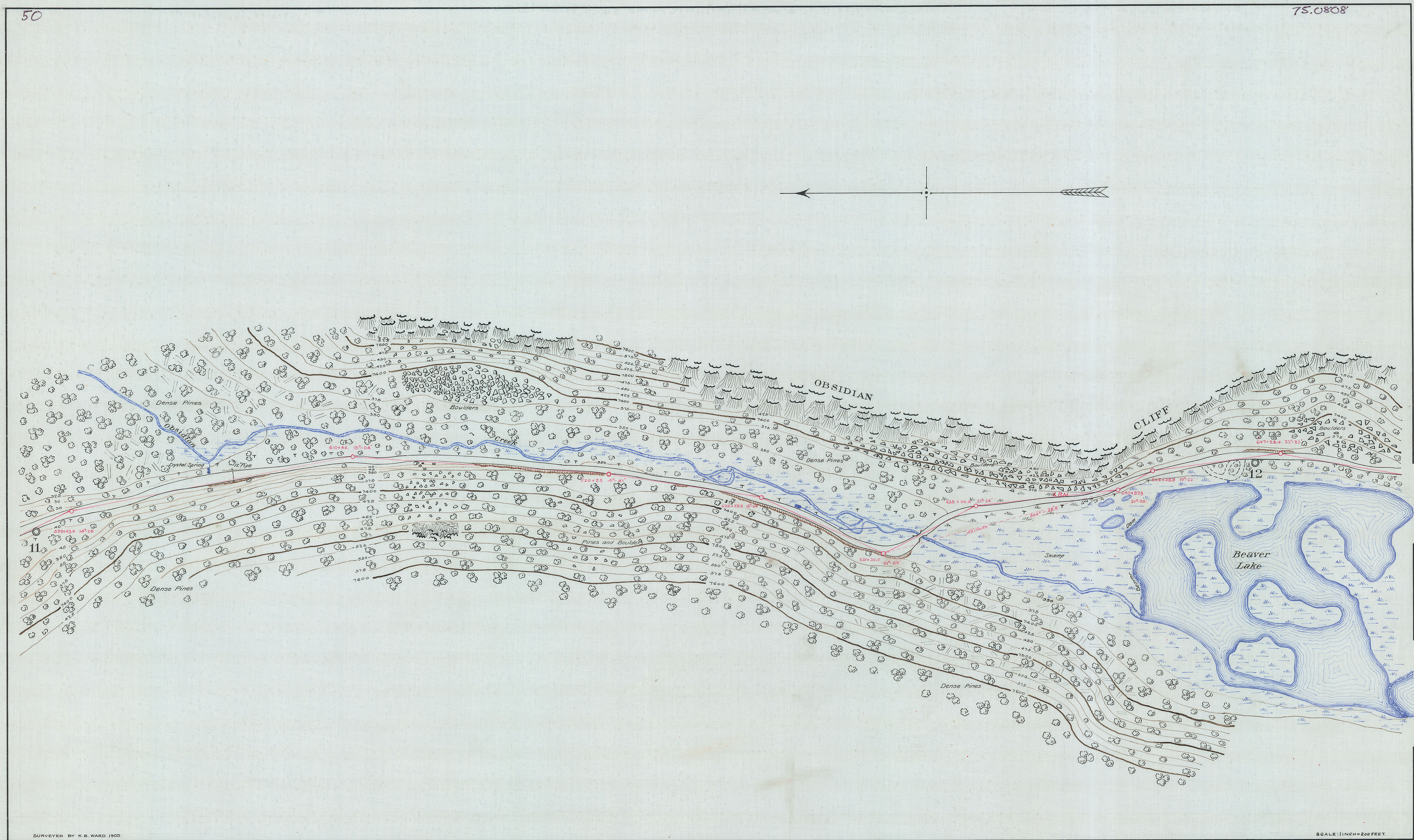 Cropped scan of Yellowstone National Park Road Surveys map, made under the direction of Major H.M. Chittenden, Corps of Engineers, by the Civil Engineering Department of Ohio State University: Mammoth Hot Springs to Norris Basin, 1905, YELL145676-M615L, found in RG Maps: Maps & Drawings Collection, Series I: Army Era, Subseries 2: Roads, Folder 7, National Archives-Yellowstone National Park.
CITATIONS:
(1) Sherman, “Summer Surveying in Yellowstone Park [1911 Letter].” The Ohio State University Quarterly, Vol. II, No. 4 (April 1911), 16-21. Material digitized here: https://archive.org/details/ohiostateunivers24coluuoft
(2) Sherman, “1905-Yellowstone.” Ohio State University, Department of Civil Engineering: A Commemorative Bulletin (July 1910), 27-28. Material digitized here: https://hdl.handle.net/2027/mdp.39015076402612
(3) “Report of Capt. Hiram M. Chittenden, Corps of Engineers, Executive & Disbursing Officer of the Board, January 20, 1896.” Annual Report of the Chief of Engineers, United States Army, to the Secretary of War for the Year 1896, Part V, 2996-2997. Material digitized here: https://hdl.handle.net/2027/uc1.b2980359
(4) Sherman, “Present Instructors.” Commemorative Bulletin, 14; Letters written by Acting Superintendent George Anderson and addressed to C.E. Sherman, found in “Letters Sent 1896-1897” Bound Volume, RG 00: Army Era Records, National Archives-Yellowstone National Park
(5) Ohio State University, Thirty-Fourth Annual Report of the Board of Trustees to the Governor of Ohio for the Year ending June 30, 1904, Part II, 16. Material digitized here: https://archive.org/details/annualreportboa03univgoog; Report of the Acting Superintendent of the Yellowstone National Park to the Secretary of the Interior, 1899, 8. Material digitized here: https://archive.org/details/reportofactingsu1899unit
(6) Sherman, “1905-Yellowstone.” A Commemorative Bulletin, 27-28.
(7) Sherman & Schlafly, “Summer Survey Courses: 1905, Yellowstone Park.” Society for the Promotion of Engineering Education: Proceedings of the Twenty-First Annual Meeting held in Minneapolis, Minnesota, June 24, 25, &26, 1913, Vol. XXI, 301-302. Material digitized here: https://archive.org/details/engineeringeduca21soci
(Images)Cropped scans of original maps produced by the 1905 Ohio State Civil Engineering Survey Parties, found in RG Maps: Maps & Drawings Collection, Series I: Army Era, National Archives-Yellowstone National Park
[Note: Italicized quotes drawn from Sherman’s 1911 letter; see citation (1)]
|
September 09, 2026
|
Last updated: September 9, 2026