![]()
Cover Page
MENU
![]() Manzanar
Manzanar
|
| |
Confinement and Ethnicity: An Overview of World War II Japanese American Relocation Sites by J. Burton, M. Farrell, F. Lord, and R. Lord |

|
|
| |
Chapter 8 (continued)
Manzanar Relocation Center
Outlying Area
Sewage Treatment Plant
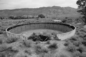 Figure 8.109. Clarifier at the Manzanar sewage treatment plant. |
The sewage treatment plant, located about 1 mile southeast of the relocation center residential area, was connected to the relocation center via a 4,600-foot-long sewerline. Manholes were spaced along the pipeline at 100 foot to 300 foot intervals, but many of the manholes have been destroyed.
Evidence of all of the sewage treatment plant structures remain (Figures 8.108 and 8.109). The control room remains consist of the 3-foot high raised concrete slab foundation of a three room structure measuring 30 feet east-west by 60 feet north-south. There are remnants of a decorative rock alignment on the north side of the foundation. North of the control room foundation, there is a series of concrete tanks of various proportions connected by 18-inch diameter concrete pipe which totals about 220 feet in length.
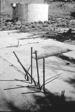 Figure 8.108. Control room and digester at the Manzanar sewage treatment plant. |

 Top
Top
Last Modified: Fri, Sep 1 2000 07:08:48 pm PDT
http://www.cr.nps.gov/history/online_books/anthropology74/ce8o.htm
![]()