![]()
Cover Page
MENU
![]() Jerome
Jerome
|
| |
Confinement and Ethnicity: An Overview of World War II Japanese American Relocation Sites by J. Burton, M. Farrell, F. Lord, and R. Lord |

|
|
| |
Chapter 7 (continued)
Jerome Relocation Center
Outlying Areas
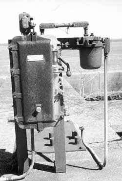 Figure 7.28. Equipment at the Jerome sewage treatment plant today. |
No other outlying features definitely associated with the relocation center were identified. West of the relocation center and U.S. Highway 165 are the Jerome railroad siding and the old highway (Figure 7.29). When the relocation center was in use, the highway was on the west side of the railroad. The present highway, east of the railroad, was constructed through the western edge of the central area, where H Street, the boundary fence, and the west patrol road were once located.
Most of the surrounding countryside, including the scout camp, is now irrigated fields or fish farms. Little remains of the forest that covered most of the area in the 1940s. Currently-used ditches follow the 1940s alignments. All are unlined, and have steel pipe control gates and valves (Figure 7.30).
 Photo Album |

 Top
Top
Last Modified: Fri, Sep 1 2000 07:08:48 pm PDT
http://www.cr.nps.gov/history/online_books/anthropology74/ce7d.htm
![]()