![]()
Cover Page
MENU
![]() Granada
Granada
|
| |
Confinement and Ethnicity: An Overview of World War II Japanese American Relocation Sites by J. Burton, M. Farrell, F. Lord, and R. Lord |

|
|
| |
Chapter 5 (continued)
Granada Relocation Center
In spite of its small population, Granada had one of the largest and most diversified agricultural enterprises of the ten relocation centers. The farm program included the raising of vegetable crops, feed crops, beef and dairy cattle, poultry, and hogs (Figures 5.18-5.23). Even the high school had a 500-acre farm, operated by vocational agriculture students (Granada Pioneer 5/19/43). Granada had an advantage over other centers in that its fields and canals were already in place, needing only minor repairs. Existing agricultural facilities were incorporated into the center's farm program: for example, the relocation center's dairy made use of an existing dairy farm, and the hotel at Koen was used as a mess hall for farm workers. A blacksmith shop located at Koen also utilized an existing facility (Figure 5.24). Expedient trench silos were used to store corn, celery, and other foods (Figure 5.25).

Fields and pastures, located to the north and east of the central developed area of the relocation center, extended to the Arkansas River and almost surrounded the town of Granada. Water for the fields was supplied by canals. Official WRA reports indicate that in 1943, 469 acres were farmed at Granada; in 1944, there were 505 acres of vegetables and 2,185 acres of field crops. A May 1943 WRA map produced at the relocation center, however, gives somewhat higher figures, with 540 acres of vegetables, 1,650 acres of grain, 515 acres of alfalfa, 2,895 acres of pasture, 340 fallow, and 855 wasteland (Figure 5.26). Some 2,380 acres of the relocation center holdings, mostly lands northwest of the town of Granada, are listed as licensed acres, probably indicating the areas were leased back to local farmers.
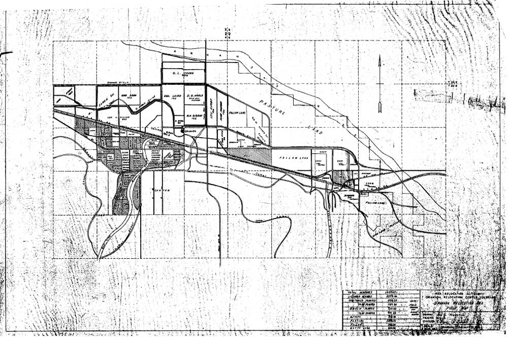 Figure 5.26. Farm fields at the Granada Relocation Center. (National Archives) (click image for larger size (~155K) ) |
WRA blueprints indicate the hog farm and at least one chicken farm were located northwest of the central area. Cattle ranch facilities may have been at the east end of the reserve, to make use of existing XY Ranch buildings. All agricultural activities likely used existing buildings, with new additions and repairs as needed. In 1944 the relocation center raised 456 cattle, 1,017 hogs, 4,712 chickens, and 2,210 egg chickens (WRA 1944).
The military police unit left the relocation center in mid-September 1945 and the Granada Relocation Center officially closed on October 15, 1945, when the last group of eighty-five evacuees departed (Simmons and Simmons 1993). The central area was sold to the town of Granada for $2,500. Through 1946 and 1947 buildings were dismantled and sold , some going to school districts in the area, some going to the town, and some hospital buildings going to the University of Denver. Other lands of the relocation center reserve were leased and then sold to local farmers, with the original buildings intact.

 Top
Top
Last Modified: Fri, Sep 1 2000 07:08:48 pm PDT
http://www.cr.nps.gov/history/online_books/anthropology74/ce5c.htm
![]()