![]()
Cover Page
MENU
![]() Tule Lake
Tule Lake
|
| |
Confinement and Ethnicity: An Overview of World War II Japanese American Relocation Sites by J. Burton, M. Farrell, F. Lord, and R. Lord |

|
|
| |
Chapter 13 (continued)
Tule Lake Relocation Center
Central Fenced Area
Evacuee Residential Area
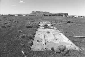 Figure 13.34. Concrete slab foundation of combination men's and women's latrine and shower building in Ward 7. |
Along a post-relocation center road in the western end of the central area the foundation slabs of some of the communal buildings within two blocks of Ward 7 remain. The size and layout of two of the slabs indicate they were the combined men's and women's latrine and shower building; one of the slabs has been damaged by the new road (Figures 13.34-13.37). Other slabs remain from laundry buildings, and concrete bins for the storage of heating coal are still present (Figure 13.38). Nearby, in a field south of an access road to the airport, there is a segment of basalt and concrete-lined ditch and a culvert from a relocation center road (Figure 13.39).
There are few artifacts in the cleared irrigated areas; these include small intact bottles, jar fragments with 1940s date marks, other glass fragments, a few hotel ware ceramic fragments, abundant coal, lumber fragments, drywall fragments, concrete debris, stove pipe, and animal bone fragments. At the relocation center high school site there are manholes and numerous foundation blocks (Figure 13.40), apparently little disturbed in spite of grazing and other activities in the vicinity.
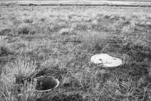 Figure 13.44. Manhole in Ward 8. |


 Top
Top
Last Modified: Fri, Sep 1 2000 07:08:48 pm PDT
http://www.cr.nps.gov/history/online_books/anthropology74/ce13i.htm
![]()