![]()
Cover Page
MENU
![]() Tule Lake
Tule Lake
|
| |
Confinement and Ethnicity: An Overview of World War II Japanese American Relocation Sites by J. Burton, M. Farrell, F. Lord, and R. Lord |

|
|
| |
Chapter 13 (continued)
Tule Lake Relocation Center
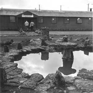 Figure 13.13. Administration building at Tule Lake. (Francis Stewart photograph, Bancroft Library, University of California, Berkeley) |
To the east of the administration area in the warehouse area there were 71 buildings. Many of these were warehouses, others included ten staff houses, three buildings used for an evacuee furniture factory, a bakery, and a tofu factory. During use of the center seven buildings from the warehouse area were moved to other areas. One was used for a funeral parlor, one for an office, one was split and used for the farm kitchen and a bunk house at one of the sewage treatment plants. Four were moved to the stockade when it was constructed.
East of the warehouse area was the industrial area, which included two railroad spurs, an office, ten warehouses, and a coal shed. Later, a latrine and three large buildings (60 feet by 300 feet) were added. One of the large buildings was a potato warehouse and the other two were to be used for factories, but were instead used for storage.
After Tule Lake was designated a segregation center a new, more secure entrance, a larger military police compound, a motor pool, and other facilities were built to the west of the original military police com-pound, which was converted to staff housing. As staff housing, the former military police compound included 27 staff houses, a dormitory, two latrines, two laundries, a warehouse, three garages, and an office. An elementary school for the children of the Caucasian staff was located in the open area between the staff housing and the highway. Older children of the Caucasian staff went to high school at the town of Tulelake. The relocation center post office was located at the north end of the staff block to allow access from both sides of the security fence built between the administration area and the evacuee housing.
The new WRA motor pool area, constructed between the staff housing and the new military police compound, included two offices, two repair shops, a gas station, a latrine, a wash rack, two grease racks, a storage shed, and a vehicle shed.
The new military police compound, in the west corner of the central area, housed an entire battalion (31 officers and 900 enlisted men; eventually 1,200 soldiers would be assigned to Tule Lake). The compound included a headquarters building, a military jail, a theater/ chapel, a post exchange, a fire station, two classroom buildings, three officers' quarters, an officers' mess hall, an officers' recreation building, 22 enlisted men's barracks, two enlisted men's mess halls, four enlisted men's recreation buildings, five supply rooms, a warehouse, a cold storage building, an ordnance building, and a substation and auxiliary power supply. To the south, the military police motor pool included a gas station, two latrines, a wash rack, a grease rack, two sheds, a motor repair shop, an office, a warehouse, a utility building, and a carpenter and paint shop.
The new entrance to the center was along the northwestern fence between the evacuee area and the new military police compound. Access from the highway was via a road along the outside of the fence. At the new entrance was a vehicle gate, a sentry post, and two pedestrian turnstiles (one on each side of the road). From the gate the road entered the central area and continued east 1,600 feet through a large open area between two security fences to another gate. This inner gate was the farm workers' embarkation area, where there was another sentry post and multiple turnstiles for pedestrians, with gates on either side for vehicles (Figure 13.14), a processing building to one side, and a parcel inspection building on the other.
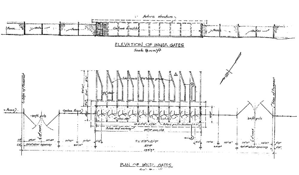
Figure 13.14. Detail of inner gate at Tule Lake.
(National Archives)
(click image for larger size (~67K) )
There were other gates along the perimeter security fence, some with sentry posts (gate houses): one to each of the two sewage treatment plants, the old main gate, two at the railroad spur, and one from the highway to the military police area. There were also four gates along the fence constructed between the administration and the evacuee residential areas.
Unique features of the Tule Lake center were the stockade, a 250-foot-by-350-foot area enclosed by fences and watch towers, and a jail located to the north of the stockade. The stockade watch towers included one original perimeter tower and three others moved from outlying farm areas. The side of the stockade towards the evacuee housing area was paneled to inhibit communication between those within and outside the stockade. Within the stockade fence there were two to five barracks, a mess hall, and a latrine (Drinnon 1987:111).
Around the perimeter of the relocation center there were originally only six watch towers, but after Tule Lake was converted to a segregation center, there was a total of 19 towers on the perimeter. The newly-constructed towers were of a slightly different design (Figure 13.15). In addition to the lighted 6-foot-high perimeter fence topped with barbed wire, there was a warning fence 50 feet in from the perimeter fence (Figures 13.16 and 13.17). A WRA blueprint depicts the warning fence as about 3-1/2 feet high, constructed of wood posts with wood rails, barbed wire, and warning signs.
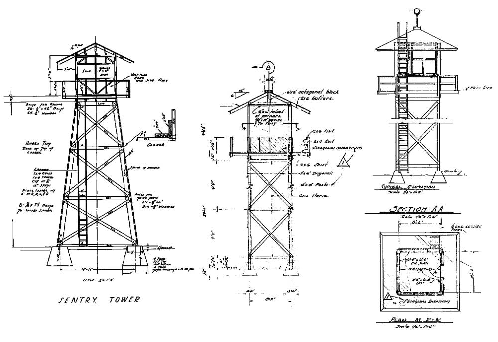
Figure 13.15. Watch tower designs at Tule Lake, left 1942, middle and right 1943.
(National Archives)
(click image for larger size (~82K) )
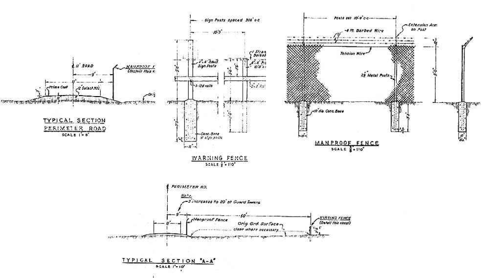
Figure 13.16. Details of the perimeter road and security fences at Tule Lake.
(National Archives)
(click image for larger size (~51K) )
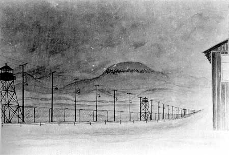 Figure 13.17. Evacuee painting of the lighted perimeter fence at Tule Lake. (Drinnon 1987:95) |

 Top
Top
Last Modified: Fri, Sep 1 2000 07:08:48 pm PDT
http://www.cr.nps.gov/history/online_books/anthropology74/ce13c.htm
![]()